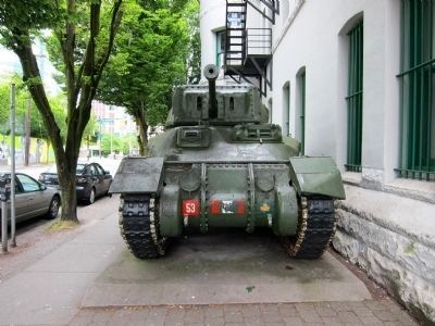
On Beatty Street at Dunsmuir Street, on the right when traveling north on Beatty Street.
Crew 5, Wt 30 tonnes, Speed 40 km/hr, armament - 57 mm main gun, 2 x 30 cal mg, in service 1941-1945.
The Ram tank was designed and built in Canada as part of Canada's contribution to the allied war effort in WW II. A total of 1949 Ram tanks . . . — — Map (db m54263) HM
On West Georgia Street just west of Richards Street, on the right when traveling west.
Built in 1929 for the brokerage firm S.W. Randall Company, this commercial building is a good example of the design of the city's downtown office development at the time of the Great Depression. The brick cladding is enriched by the terra cotta . . . — — Map (db m54834) HM
On East Hastings Street at Jackson Avenue, on the right when traveling east on East Hastings Street.
In 1922 Ferrera Court was the home of Vancouver tailor David Marks, where vaudeville comedian Benny Kubelsky met thirteen-year-old Sadie Marks. They dated in 1926 and married the next year. As Jack Benny and Mary Livingstone they often returned to . . . — — Map (db m46691) HM
On Beatty Street at Dunsmuir Street, on the right when traveling north on Beatty Street.
M4A3E8, Crew 5, Wt 32 tonnes, speed 48 km/hr armament - 76 mm main gun, 2 x 30 cal mg in service 1943-1970
On 8/9 August 1944, the British Columbia Regiment (Duke of Connaught's Own), then designated Canadian 28th Armoured Regiment, was commanded . . . — — Map (db m53942) HM
On Dunsmuir Street at Seymour Street, on the left when traveling west on Dunsmuir Street.
Of the turn-of-the century hotels built in the downtown area before World War I, this is the last one that has survived as a hotel. Noted architect W.T. Whiteway designed it in 1913. He was the architect of the Sun Tower, the original 1903 Woodard's . . . — — Map (db m41988) HM
Near Stanley Park Drive, 0.3 kilometers north of West Georgia Street.
The Vancouver Rowing Club was established in 1899 when the Burrard Inlet Rowing Club joined the Vancouver Boating Club. Throughout it's history the Vancouver Rowing Club has played an important part in the athletic and social life of Vancouver. This . . . — — Map (db m31941) HM
On Dease Lake Highway/Stewart-Cassiar Highway (Provincial Highway 37) 5.6 kilometers south of Bob Quinn Forest Service Road, on the right when traveling south.
Born of the Klondike Gold Rush of 1898, the 1,900 mile Dominion Telegraph Line linked Dawson City with Vancouver via the CPR wires through Ashcroft. Built in 1899-1901, the line blazed a route across this vast northern section of the Province but . . . — — Map (db m187925) HM
On Yellowhead Highway (Provincial Highway 16) 13 kilometers south of Cedarvale Ferry Road, on the right when traveling south.
From 1889, sternwheelers and smaller craft fought their way through the Coast Mountains, churning past such awesome places as “The Devil's Elbow” and “The Hornet's Nest”. Men and supplies were freighted upstream, furs and gold downstream. A quarter . . . — — Map (db m187963) HM
On Highway 62 just north of Tse Kya Road, on the left when traveling north.
First bridge built in 1856
Described as a graceful wooden spiderweb, the first Hagwilget Bridge was built by the indigenous population using only knives and axes. It was 150 feet long, and swayed 100 feet above the churning waters of the . . . — — Map (db m198556) HM
On Government Street at Bay Street, on the left when traveling north on Government Street.
Head of sternwheeler navigation on the Skeena. The town grew at the landing close to the Indian village of Gitenmaks. Crews from the Collins Telegraph arrived in 1866. Following them Omineca gold miners, Hudson’s Bay pack strings and “gandy . . . — — Map (db m9073) HM
On Yellowhead Highway (National Route 16), on the right when traveling west.
This site, once the largest village of the Bulkley Valley Indians, later was named after the pioneer missionary, Father Morice. Salmon, staple food of the Indian, concentrated in the canyon and were caught with basketry traps, dip-nets, and . . . — — Map (db m9072) HM
The Gitxsan are people of the Skeena River or River of Mist. For 10,000 years the Gitxsan have dwelled in their traditional territory and today approximately 13,000 members live in communities known as Gitwangak, Gitanyow, Gitsegukla, Hagwilget, . . . — — Map (db m187933) HM
On Crowsnest Highway (Provincial Highway 3) at Boundary Smelter Road, on the right when traveling east on Crowsnest Highway.
Although prospectors like "Jolly Jack” Thorton worked this area during the 1860s, Boundary Falls was not settled until the 1890s, when a new breed of miners flooded the district. Surrounded by mining properties, the Boundary Falls Smelter (also . . . — — Map (db m187917) HM
On British Columbia 395, 0.1 kilometers east of Crowsnest Highway (Provincial Highway 3), on the left when traveling east.
Cascade came into being during the late-1890s as a bustling railway construction town claiming 17 hotels at its height. Its location along the Canada-U.S. border proved strategic for mining, freighting, and hydro-electricity. The early development . . . — — Map (db m187915) HM
On Crowsnest Highway (Provincial Highway 3) 2 kilometers west of Wilgas Lake Rest Area, on the left when traveling west.
In 1900, the CPR's Columbia & Western Railway penetrated the formidable mountains between Nelson and Midway, connecting the Boundary district to East Kootenay coalfields and beyond. Eholt, at the summit between Grand Forks and Greenwood, became the . . . — — Map (db m187908) HM
On Crowsnest Highway (Provincial Highway 3) 3.4 kilometers west of Stewart Creek Road, on the left when traveling west.
Doukhobors arrived in the Kootenay Boundary area in 1908. Persecuted in Russia for rejecting church rituals and military service, they were derisively named Doukhobors, or ‘Spirit Wrestlers’. Finding refuge in Canada, these Christian pacifists . . . — — Map (db m187884) HM
On Smelter Viewpoint at Butte Avenue, on the right when traveling south on Smelter Viewpoint.
During the prosperous years of the late 1890s, this street was one of the busiest thoroughfares in the province. Little wonder, for in those years copper was king, and Greenwood — incorporated as a city in 1897 — was the capital of the copper-rich . . . — — Map (db m187914) HM
On Smelter Viewpoint at Butte Avenue, on the left when traveling north on Smelter Viewpoint.
In this wilderness of rugged mountains, ore was first found in the late 1880's. Further prospects led to the building of a large smelter by the B.C. Copper Co. From 1901, copper, gold and silver poured from its furnaces. Fed by the great Motherlode . . . — — Map (db m187998) HM
On Crowsnest Highway (Provincial Highway 3) just west of Beamish Street, on the right when traveling west.
When the Midway to Hope section of the “K.V.” was completed in 1916 and joined with existing short lines, it formed a direct southern railroad from Alberta to the Pacific Coast. An important factor in advancing the economy of southern B.C., it has . . . — — Map (db m187941) HM
On 5th Avenue at Florence Street, on the right when traveling east on 5th Avenue.
Proximity to Boundary Creek mines, and excellent climate, water and soil convinced Midway promoters of a bright future as a "railway and residential town.” The Columbia & Western Railway reached Midway in 1900; five years later, the Vancouver, . . . — — Map (db m187938) HM
On Provincial Highway 3B at Paterson-Trail Highway (Provincial Highway 22), on the right when traveling west on Provincial Highway 3B.
You have entered the crater of an ancient volcano rich in minerals. The waste dumps are the remains of famous Rossland mines staked in 1890 by prospectors passing on the near-by Dewdney Trail. From these fabulously rich workings came 6,000,000 tons . . . — — Map (db m187953) HM
Near Paterson-Trail Highway (Provincial Highway 22) 1.1 kilometers north of King George Park Road.
"A travel route north of the boundary line" was the cry in the 1860's when gold was found in the Kootenays. Edgar Dewdney built such a route — a trail 360 miles long from Coast to Rockies.
For over two decades it carried miners, settlers, gold . . . — — Map (db m187959) HM
On Gunderson Road just south of Elevator Road, on the right when traveling south.
This site, on the world's greatest salmon river, lured many pioneer canners in the late 1860's and early 1870's. Pre-eminent was Alexander Ewen, a founder and first president of B.C. Packers, who established a cannery here in 1871. The new salmon . . . — — Map (db m187923) HM
On Royal Avenue at Merivale Street, on the right when traveling east on Royal Avenue.
Arriving in British Columbia from the United States in 1859, Scottish-born Capt. William Irving pioneered the riverboat trade of the lower Fraser River. In 1862-64, Royal Engineers built his fine home of California redwood in the popular San . . . — — Map (db m187992) HM
On Esplanade Avenue, 0.4 kilometers north of Murray Street, on the right when traveling north. Reported missing.
Colonel R.C. Moody, R.E., recognized the potential value of Burrard Inlet for military defence. Named in his honour, Port Moody became the western terminus of the Canadian Pacific Railway. Although a branch line was built in 1887 to the growing city . . . — — Map (db m187971) HM
In commemoration of the tenth anniversary of the terror attacks of September 11, 2002, the United States Consulate General in Vancouver, on behalf of the people of the United States, wishes to thank the people of British Columbia for their support . . . — — Map (db m236164) HM
On Water Street, on the right when traveling west.
William Harold Malkin, a wholesale grocer and general merchant, built three warehouses on Water Street within eight years. This massive brick and timber warehouse, his third, was constructed to meet the growing demand. The W.H. Malkin Co. prospered . . . — — Map (db m236408) HM
On Stanley Park Drive, on the left when traveling west.
You are standing on thousands of years of history. The clearing around Lumbermen's Arch has been the perfect gathering spot for generations.
Place of the Mask
The local Coast Salish named this site Xwdyxway (pronounced whoi . . . — — Map (db m236022) HM
On Carrall Street, on the left when traveling south.
This hotel dates back to 1887, part of the rapid development of the city prior to and upon arrival of the Canadian Pacific Railway. The original hotel here, known as Tremont House, was a wood frame building with a second floor balcony spanning the . . . — — Map (db m236472) HM
On West Hastings Street, on the right when traveling north.
BC & Yukon Chamber of Mines
Architect: John C. Day
This was built in 1926 as the corporate offices for the Royal Financial Trust Co., in Classical and Gothic ornamentation with terra cotta cladding. By 1931 the company was . . . — — Map (db m236785) HM
Near Stanley Park Drive, on the right when traveling west.
During its heyday, the Brockton Point Lighthouse played a key role in guiding ships safely in and out of Coal Harbour.
Early Warning System
The first Brockton Point lighthouse, built in 1890, alerted ships to shore-related dangers and . . . — — Map (db m198612) HM
Built to service the trading forts of the Hudson's Bay Company, the BEAVER regularly steamed the H.B.C.s territory between Puget Sound and Russian Alaska for 24 years. In 1862, the BEAVER was chartered to the Royal Navy and, after a refit, began a . . . — — Map (db m236206) HM
CARVED IN 1987 BY NISGA’A ARTIST NORMAN TAIT ALONG with his son Isaac, brother Robert, and nephew Ron Telek, this pole depicts how the Tait family's Eagle clan adopted the beaver as their crest, and how the eagle and raven met and shared the . . . — — Map (db m236192) HM
The local Coast Salish people gathered clams and mussels along these shores when this lagoon was a saltwater inlet of Coal Harbour.
[caption] Lost Lagoon got its name in the earl 1900s from Canadian poet Pauline Johnson, who presented the name . . . — — Map (db m236365) HM
On Carrall Street, on the left when traveling north.
The Byrnes Block was built after the fire of 1886 by George Byrnes. It stands on the site of the Deighton House, Gassy Jack Deighton’s second saloon and hotel.
The buildings housed the Alhambra Hotel, one of the city's fancier hotels at the . . . — — Map (db m236463) HM
Canada Pacific Railway Station
Architects: Barott, Blackader & Webster
As the terminus for the Canadian Pacific Railway, this site has been an important landmark since the completion of the railway in 1886. This Neo-Classical . . . — — Map (db m236312) HM
From May 2, to October 13, 1986, Canada Place was the home of the Canada Pavillion at the 1986 World Exposition. The Canada Pavillion images depicted in this sculpture represent the enterprise, excellence, and beauty of Canada, whose . . . — — Map (db m236378) HM
Canada Place was the Canadian Pacific Railway's Pier B-C ocean liner terminal in the 1920s. In 1982, the Government of Canada redeveloped it as the Canadian Pavilion for The Expo '86 World Fair and dedicated it as a legacy for the Canadian people. . . . — — Map (db m236308) HM
On West Hastings Street, on the right when traveling east.
Ceperley Rounsefell Building
Architects: Sharp and Thompson
Built in 1921, this was the headquarters of one of the province's largest insurance and real estate firms with roots going back to the city's incorporation. Henry . . . — — Map (db m236783) HM
AN OLDER VERSION OF THIS POLE WAS RAISED IN THE Haida village of Skidegate about 1870. It honours the Raven Chief of Skedans and depicts the chief's hereditary crests. The two tiny figures in the bear's ears are the chief's daughter and son-in-law . . . — — Map (db m236187) HM
IN KWAKWAKA'WAKW (KWAKIUTL) CEREMONIES, CARVED staffs called talking sticks are held by people making important speeches on behalf of a chief. This pole represents the talking stick and characters in an Owikeno story belonging to Chief Wakas. The . . . — — Map (db m236193) HM
Cordage Building
Architect: Hugh Braunton
This residential hotel built in 1911 replaced an older section of the Granville Hotel which had connected to what is now the Grand Hotel to the west. Its elegant Edwardian and Classical . . . — — Map (db m236411) HM
Near Stanley Park Drive when traveling north. Reported missing.
Originally built to access the North Shore, the Lions Gate Bridge is now one of the city's busiest thoroughfares with over 60,000 vehicles driving across each day.
Tension over the Suspension
In 1927, Vancouverites voted against building a . . . — — Map (db m198590) HM
Near Stanley Park Drive, on the right when traveling west.
As ships navigated the Narrows' powerful tidal flows, they relied on warnings from the Prospect Point Lighthouse to stay clear of its rocky hazards.
Response to Disaster
In 1888, just off this point, the historic steamship S.S. Beaver ran . . . — — Map (db m198611) HM
Once a thriving logging town, the downtown of Vancouver's skyline is now dominated by
residential and retail developments, corporate headquarters, hotels and the distinctive
"sails" of the convention and cruise ship centre. The City of Vancouver . . . — — Map (db m236126) HM
James Till PhD and Ernest McCulloch MD are globally recognized as the Fathers of Stem Cell Science for their research in the 1960s at the Ontario Cancer Institute and Princess Margaret Hospital, Toronto. They received Canada's Gairdner . . . — — Map (db m236487) HM
On Water Street at Cambie Street, on the left when traveling west on Water Street.
On this site the Regina Hotel, the only building in Gastown to survive the fire of 1886. A small group of men trapped in the building fought to save their lives and managed to save the building as well. The Regina was demolished in 1906 and replaced . . . — — Map (db m236401) HM
On West Hastings Street at Granville Street, on the left when traveling north on West Hastings Street.
In 1888, the Bank of British Columbia and the Bank of Montreal became the first of many financial institutions to open their offices on Hastings Street west of Cambie. By 1912, Hastings was firmly established as the city's financial district with . . . — — Map (db m236313) HM
First Known AIDS Memorial
Planted on October 20, 1985
The grove was planted, and this plaque donated by staff friends and loved ones of AIDS Vancouver.
This grove of cherry trees is a living monument, planted in loving . . . — — Map (db m236211) HM
In the area then known as West Capilano, and today as Ambleside, a former Canadian Pacific Railway conductor. John Lawson, purchased land in 1906. He moved his family there the following year, Lawson had big ideas for his land, which he christened . . . — — Map (db m235892) HM
This grassy area, now Devonian Harbour Park, represents lavers of historic use from early settlement to industrial waterfront.
Coal Harbour
In 1859 Captain George Henry Richards from the British Royal Navy named this bay Coal Harbour, . . . — — Map (db m235893) HM
GA'AKSTALAS, CARVED BY WAYNE ALFRED AND BEAU DICK IN 1991, is based on a design by Russell Smith. The pole depicts many important figures in Kwakwaka'wakw culture. Red Cedar-bark Man is an ancestor who survived the great flood and gave the people . . . — — Map (db m236188) HM
This clock is located at the western boundary of the old Granville townsite, known as Gastown. In 1870, the shore of Burrard Inlet was only a few yards north of this point. Through the early 1900's, Gastown was the commercial centre of Vancouver. . . . — — Map (db m236389) HM
George Leslie's Lane Cottage
Builder: George Leslie
This circa 1901 Yaletown home was relocated to Mole Hill in 2002 and restored by the Vancouver Heritage Foundation. It was originally situated on the lane at [t]he rear of . . . — — Map (db m236746) HM
On Water Street, on the right when traveling west.
Greenshields Building
Builder: J.J. McLuckie
This former Warehouse was constructed in 1901-02 as two separate buildings designed to appear as one. Greenshields, Son & Company was a prominent Montreal-based dry goods firm which . . . — — Map (db m236396) HM
Commemorating the pioneering of the work of the Salvation Army in Vancouver. It was on this clearing the Salvation Army erected a rugged shelter, picnic tables, and then held services of song. In the silent atmosphere of early Burrard Inlet, the . . . — — Map (db m236209) HM
"The will to do, the soul to dare"
Sir Walter Scott
Harry Winston Jerome
Born September 30, 1940
Died December 7, 1982
British Columbia's Athlete
of the Century 1871-1971
World Records
1960 100 yards 9.3 seconds
. . . — — Map (db m236027) HM
Her Majesty's Canadian Ship Discovery was commissioned on November 1, 1941. Thousands of men and women have been recruited and trained at these naval reserve facilities of Deadman's Island for service to Canada in peace and war.
World War . . . — — Map (db m236197) HM
On West Georgia Street at Howe Street, on the right when traveling north on West Georgia Street.
This distinguished hovel designed in the Georgian Revival style was opened in 1927 by Edward Prince of Vale, who later became King Edward VII. Though the 1920s prominent buildings such as this were quickly replacing the area's early houses and . . . — — Map (db m236323) HM
On Hornby Street, on the left when traveling north.
Architects: John S. Archibald & John Schofield
In 1887, the first Hotel Vancouver opened at Georgia and Granville Streets. It was replaced in 1916 by more lavish building at the same location. In 1928, construction began on the third and . . . — — Map (db m236318) HM
The totem was the British Columbia Indian's "Coat of arms", totem poles are unique to the North west coast of B.C. and lower Alaska. They were carved from western red cedar and each carving tells of a real or mythical event. They were not idols, nor . . . — — Map (db m236186) HM
This ancient symbol of the Inuit culture is traditionally used as a landmark and navigational aid and also represents northern hospitality and friendship. Constructed of grey granite by Alvin Kanak of Rankin Inlet, this monument was commissioned by . . . — — Map (db m236351) HM
Jack Poole was a giant or a man, a builder of better communities who voluntarily provided
exceptional leadership with an unwavering commitment to the public good as exemplified by his extraordinary service as Chairman of the Vancouver Organizing . . . — — Map (db m236212) HM
KWARWARA' WARW CARVER ELLEN NEEL AND HER UNCLE Mungo Martin were among the first artists to achieve wide recognition for their totem poles commissioned by museums, cities, and art collectors. Neel was also the first woman to become a Northwest . . . — — Map (db m236194) HM
On May 23, 1914, the steamship Komagata Maru arrived in Coal Harbour after a seven week crossing from Hong Kong via Japan. The ship was carrying 376 Indians from India and the Far East who claimed right of entry as citizens of the British Empire. . . . — — Map (db m236311) HM
The Guinness brewing family built the Lions Gate Bridge which opened in 1938 to provide access to its British Properties lands in West Vancouver. Ownership was transferred to the Province in 1955. Tolls were removed in 1963 and the bridge was . . . — — Map (db m236789) HM
This was one of the first parking garages in Vancouver, opened in 1930. It was operated by Nagle Bros. until 1937, an early service facility for tracks that moved goods from Gastown warehouses. In the late 1940s it became the Water Street Garage. . . . — — Map (db m236412) HM
On Granville Street, on the right when traveling north.
Orpheum Theatre
Architects: B. Marcus Priteca & Frederick J. Peters
The Orpheum, built and financed by local entrepreneur Joseph F. Langer, was part of the Chicago-based Orpheum Circuit theaters. It opened in 1927 as the largest . . . — — Map (db m236733) HM
FIRST NATIONS ORIGIN STORIES TELL OF THE ANIMALS AND supernatural beings who helped found family lineages. These stories are celebrated in songs, dances, and totem pole carvings. Kwakwaka'wakw artist Oscar Maltipi carved this pole in 1968. . . . — — Map (db m236190) HM
On Expo Boulevard, on the left when traveling west.
Percy williams blasted down the track in Amsterdam at the 1928 Olympic Games to win gold in the 100 and 200 meter sprints. His unexpected Olympic victories catapulted the twenty year old, and his hometown of Vancouver, into the international . . . — — Map (db m236713) HM
This statue of Robert Burns, Scotland's National Bard, was unveiled by J. Ramsay MacDonald, a Prime Minister of Britain, on 25th August, 1928.
Robert Burn's sincere desire for friendship and brotherhood among all people is clearly shown in his . . . — — Map (db m235907) HM
The Robinson Block was built in 1889 Zebulon Franks, a Jewish immigrant from Russia who arrived in 1887, relocated his general supply store here from Carrall Street in the early 1890s. It catered to resource industry workers - loggers, fishers, . . . — — Map (db m236403) HM
On Barclay Street, on the right when traveling north.
Roedde House
Attributed to Francis Mawson Rattenbury
This Queen Anne style home of Vancouver's first bookbinder was built by Gustav and Matilda Roedde in 1893. Efforts to restore the house and establish a unique heritage park . . . — — Map (db m236348) HM
Developed to reflect the aspirations of early Vancouver, the Shakespeare Garden is a secluded arboretum of trees mentioned in the Bard's plays and poems.
The first tree was planted by Mrs. Jonathan Rogers in 1916 on the three hundred year . . . — — Map (db m236203) HM
"Our art comes from spirituality. From after the onslaught of another culture, our spirituality and our belief are alive. In this pole we wanted to acknowledge the arts and ceremonies of our grandparents' generation and show that the arts are here . . . — — Map (db m236191) HM
On Jervis Street, on the left when traveling west.
St. Paul's Anglican Episcopal Church
Architect: W.H. Archer
This attractive wooden Gothic Revival church, built in 1905, was modelled after a typical English Parish church. Regional influences in the building can be seen in . . . — — Map (db m236749) HM
The first public garden of the city was created from 1911 to 1920 by master gardener John Montgomery from unwanted boulders excavated for the adjacent park pavilion. Stretching from Pipeline Road to Coal Harbour this early park attraction, had by . . . — — Map (db m236204) HM
On Water Street, on the right when traveling east.
Taylor Building
Architects: Grant & Henderson
Walter Taylor and Edward Clarence Taylor commissioned this commercial building in 1911. Walter Taylor was the founder and managing director of the Empress Manufacturing Company, . . . — — Map (db m236398) HM
Terry Fox Plaza
Terrance Stanley “Terry” Fox
July 28, 1958 – June 28, 1981
Terry Fox was a young athlete from the Vancouver suburb of Port Coquitlam. In 1977, at the age of 18, he was diagnosed with osteosarcoma in his right knee. . . . — — Map (db m236717) HM
On Nelson Street at Howe Street, on the left when traveling north on Nelson Street.
Vancouver's postmaster, Jonathan Miller, hired four mail carriers to commence delivery in the city. Citizens were instructed regarding proper numbering and servicing began February 1, 1895, from the main post office at the N.W. corner of Granville . . . — — Map (db m236743) HM
The world's first steam powered clock has been created for the enjoyment of everyone. The live steam winds the weights and blows the whistles. Every 4.5 minutes one steel weight will travel by steam power to the top of the clock. The gravity driven . . . — — Map (db m236391) HM
The Grand Motel was built in 1889. It was known as the Granville Motel until its expansion in 1904. Designed by Noble Stonestrott Hoffar, one of Vancouver's earliest architects, it is a fine example of the Victorian Italianate style, and one of . . . — — Map (db m236409) HM
Near Lions Gate Bridge (Provincial Highway 99) north of Stanley Park Drive, on the right when traveling south.
[English] A tribute to the engineers who built and renovated this bridge, the landmark structure of the Vancouver area.
When opened in 1938, the 1550 ft. main span was the longest suspension span outside the United States. Design engineer: . . . — — Map (db m198610) HM
Following the longest national torch relay in Olympic History, the Olympic Cauldron was lit on February 12, 2010 marking the official opening of the Vancouver 2010 Olympic and Paralympic Winter Games.
Arriving from Athens, Greece, the Olympic . . . — — Map (db m236213) HM
On Water Street, on the right when traveling west.
Originally built as The Sunnyside Hotel in 1874, the property was devastated by the Great Vancouver Fire in 1886. It was rebuilt and operated as The Alexandra Hotel for several years. As of 1912, the building was home to Swift Canadian Company, a . . . — — Map (db m236457) HM
First planted by the Kiwanis Club in 1920, the Stanley Park Rose Garden now displays over 3500 bushes and features a wonderful arbor which is bedecked with the blossoms of climbing varieties throughout the summer. — — Map (db m236867) HM
Thomas Fee House
Architects: Parr and Fee
This early West End home was designed and built in 1904 as the private home of Thomas Fee, a partner in the well-known architectural firm of Parr and Fee. The firm was responsible for the . . . — — Map (db m236747) HM
This sundial commemorates three English Greenhorns Samuel Brighouse, John Morton, and William Hailstone who in 1862 filed the first claim and planned the first home and industry in the heavily wooded area now bounded by Burrard Inlet, Stanley Park, . . . — — Map (db m236361) HM
CARVED HOUSE POSTS ARE USED IN TRADITIONAL FIRST Nations cedar houses to support the huge roof beams. This pole is a replica of a house post carved by Kwakwaka' wakw artist Charlie James in the early 1900s. Tony Hunt carved this replica in 1987 to . . . — — Map (db m236189) HM
By 1865, fortunes were made in BC, thanks to world demand for the plush pelt of the northern seal.
Sealing dominated the city of Victoria's economy for nearly 50 years. At its height, 122 schooners employed over 3,000 hunters, the majority . . . — — Map (db m236307) HM
Park visitors have long gathered here, at the Stanley Park Pavilion and Malkin Bowl, to enjoy food, music and social pursuits.
GETTING TOGETHER IN STYLE
The pavilion built in 1911, became hub of social activity as one of Vancouver's . . . — — Map (db m236865) HM
On Granville Street, on the right when traveling north.
Bright lights, glamorous decor, and streamlined forms are features which make the Vogue a magnificent example of the Art Deco style. Built by the Odeon chain in 1941, the theatre was unusual in its ability to accommodate both movies and . . . — — Map (db m236740) HM
[Left]
"What an object lesson of peace is shown today by our two countries to all the world. No grim-faced fortifications mark our frontiers, no huge battleships patrol our dividing waters, no stealthy spies lurk in our tranquil border . . . — — Map (db m235996)
You can thank Vancouver's early shipping activities for this viewpoint -originally the site of a signal station that guided ships through First Narrows.
Towering Beacon of Safety
A two-storey signal station once sat atop . . . — — Map (db m236128) HM
Asbestos causes 40 percent of work-related deaths in North America.
The installation recalls the ominous history of asbestos from when it was heralded as a "magic mineral" to recognition of its devastating impact on human health.
. . . — — Map (db m236306) HM
The violent windstorm of December 2006 severely damaged more than 10% of the Stanley Park forest, downing over 10,000 trees as well as damaging the Prospect Point escarpment and the seawall below. The public response was an outpouring of financial . . . — — Map (db m236127) HM
On West 10th Avenue, on the right when traveling east.
Grocer Fred Welsh was the first owner of this home which was built in 1894 during the early development of the Mount Pleasant neighbourhood. This Queen Anne style cottage has elaborate wooden decoration including delicate brackets, shingles and . . . — — Map (db m236645) HM
On West 10th Avenue, on the right when traveling east.
This 1908 house is a good example of the Edwardian Builder style which was popular during the city's building boom in the early years of the 20th century. These wooden frame buildings were often two and a half stories with a full front porch simple . . . — — Map (db m236641) HM