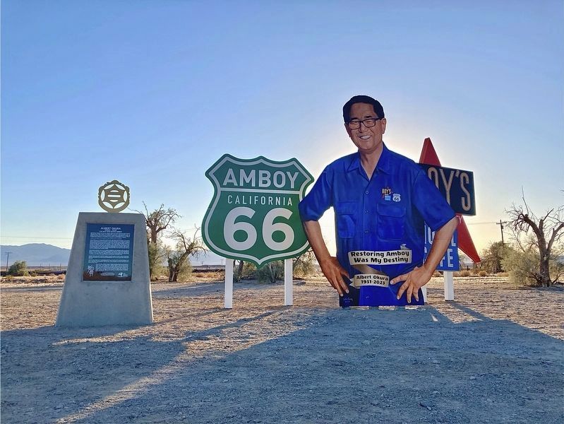
Albert Okura, a third-generation Japanese-American, was born and raised in Southern California during the
Baby Boom era. Growing up during the economic boom in the United States after World War II, he
considered himself a proud American who . . . — — Map (db m263606) HM
Amboy, settled as early as 1858, became a water stop when the Southern Pacific Railroad laid its tracks through the Cadiz Valley in 1883-84. Following the course of the railroad and the National Old Trails Highway, Route 66 was opened in 1926. Amboy . . . — — Map (db m78532) HM
Amboy Crater, formed of ash and cinders, is 250 feet high and 15,000 feet in diameter. It is situated in one of the youngest volcanic fields in the United States. It is located in the Barstow-Bristol trough, a conspicuous west-northwest trending . . . — — Map (db m249852) HM
Amboy Crater, formed of ash and cinders, is 250 feet high and 1500 feet in diameter. The crater is in one of the youngest volcanic fields in the United States. Six distinct periods of eruptions created the resulting nested group of volcanic cinder . . . — — Map (db m78561) HM
Perhaps no other highway in the U.S. is as fabled as old Route 66. It has been immortalized in song, literature, and even a T.V. series as the main street of America. Automobiles came early to the desert, following the railroad with its reliable . . . — — Map (db m78574) HM
Founded in 1858, Amboy provided a vital rest stop for weary sun drenched travelers seeking a better life in California.
Amboy owned and operated by Juan Pollo restaurants. — — Map (db m193157) HM
First named for Saint Bridget when it was founded in 1950 by the Diocese of San Diego, the parish at Amboy was renamed Saint Raymond's a year later. Founding pastor Father Patrick Malone leased a house here in Amboy for use as a rectory and . . . — — Map (db m288502) HM
Panel 1:
The Story of Route 66
Commissioned in 1926 and soon dubbed "The Mother Road," Route 66 was a great asphalt river linking Chicago and Los Angeles – a highway of hope that led thousands of people to a new life. . . . — — Map (db m33446) HM
America has always been a nation in motion: west to the Mississippi after the Revolution, west to the Continental Divide Following the Louisiana Purchase, West again to the Pacific Coast after the War with Mexico. Like many of today's railroads, . . . — — Map (db m310173) HM
During the years 1930 and 1931 the Department of Defense built a network of emergency airfields for use by commercial aviation. During WWII the government converted many of them to military use.
This is the location of Bagdad Auxiliary . . . — — Map (db m241176) HM
The dry lake bed before you was once part of ancient Lake Mojave. During the last ice age, a cooler and wetter climate produced the Mojave River. It flowed inland about 150 miles from the San Bernardino Mountains, until its waters became trapped . . . — — Map (db m83467) HM
The waters here at Soda Springs have sustained people of many cultures for thousands of years. Nomadic Chemehuevi people and the agrarian Mohave Indians visited these springs during hunting, gathering, and trading trips through the area. Their . . . — — Map (db m83465) HM
Home of the "best" fresh strawberry pie & butter thin pancakes!
First opened in Baker, CA in 1956.
Founder: Willis Herron and partner J.O. Failing.
Original Building 1956-1990, one of three restaurants in Baker.
Restaurant was . . . — — Map (db m263496) HM
Francis Marion "Borax" Smith built the railroad to move borax out of the hills and Death Valley in 1907 to replace the twenty mule teams that crossed this way to Ludlow. — — Map (db m123898) HM
Some 100 wagons found themselves in Salt Lake City too late to cross the Sierra Nevada. They banded together under the name of Sand Walking Co. and started for the gold fields in California over the old Spanish Trail. After being in Death Valley . . . — — Map (db m159400) HM
Marl Springs
Marl Springs was named in 1854 by Army Surveyor Lt. Amiel Whipple for the clay-like soil around the two waterholes. With the establishment of Fort Mojave in 1859, the Mojave (or Old Government) Road came into existence. Marl . . . — — Map (db m159025) HM
Though they comprise less than 9 percent of the 270 million acres of public lands administered by the U.S. Bureau of Land Management, riparian and wetland areas, such as Salt Creek, are considered the most productive resources found on public lands. . . . — — Map (db m72926) HM
This area was the focus of both prehistoric...American activities and historic...mining. The rich environment provides...for numerous species.
Please...protect these natural and c... This ACEC is open for hiking and non...d vehicle use. . . . — — Map (db m72928) HM
In 1860 the U.S. Army established an outpost at Soda Springs to protect government supplies from Indians. Later, miners processed the adjacent lake minerals. In 1906 the Tonopah & Tidewater railroad arrived. From 1944 to 1974 Dr. Curtis H. Springer . . . — — Map (db m78587) HM
[Panel #1]
1776 - 1830: Early Explorers
Francisco Garces
1776 - As the Revolutionary War broke out, California was still a province of Spain, and the Spanish government decided to help feed a hungry Mexico by farming the . . . — — Map (db m83575) HM
Dedicated on this
Saturday, October 11, 2014,
to Willis and Barbara Herron,
original owners / founders of the
World’s Tallest Thermometer.
Facts:
Built in 1991, 134 feet tall,
representative of the world's hottest . . . — — Map (db m159379) HM
The Last Word and the Last Chance
In 1944, radio evangelist Curtis Howe Springer
filed a mining claim on public lands here at
Soda Springs and established Zzyzx Mineral
Springs resort. Over the next 30 years,
Springer transformed . . . — — Map (db m221075) HM
His Expedition (sic) for a transcontinental railroad, crossed the Colorado River on Feb. 27, 1854 and 3 weeks later reached Los Angeles, receiving aid from the Mojave Indians. The Atcheson, Topeka, & Santa Fe Railroad followed Whipple’s trail for . . . — — Map (db m50577) HM
Harvey Houses were legendary in the history of Western rail travel. Operated by Fred Harvey in conjunction with this Santa Fe Railway, the network of restaurant-hotels set a new standard in quality meal service. Barstow's Spanish-Moorish "Casa Del . . . — — Map (db m50666) HM
The mural depicts the interesting places and people of Barstow Route 66.
On the far left of the mural you will see a 1947 three wheeled Harley Davidson Service Car used by Barstow Police department for parking enforcement to collect money and . . . — — Map (db m286075) HM
One of the finest surviving examples of California's depot-hotels built around the turn of the 19th century. It's also home to the Route 66 "Mother Road" Museum and the Western American Railroad Museum (W.A.R.M.).
Recognized by Hampton . . . — — Map (db m193156) HM
Brubaker Mann Inc. started production in 1950 when two cousins, Ronald Brubaker and William Mann conceived a new project – naturally colored rock to be used for roofing and landscaping. Growing up in Pomona, the two men developed a love for the . . . — — Map (db m288445) HM
April 6, 1881, S.C. Warden, Hues Thomas and John C. King located claims on Calico Mountain and named it the Silver King Mine. Below there, the town of Calico grew from 100 people in the spring of 1882 to over 1,200 at the peak of the rush. . . . — — Map (db m108837) HM
Dedicated in honor of Barstow-Kennedy High School student Eugene F. Christiansen – US Army.
Born February 16, 1949.
M.I.A. February 6, 1969, Republic of Viet Nam.
Barstow, California – 1990 — — Map (db m50539) HM
In early 1776, he set out northward from Yuma Villages on the Colorado River on a journey that took him across the Mojave Desert to the Mission of San Gabriel. He was a master of finding guides who would escort him through their own lands. — — Map (db m50562) HM
Prehistory
Ancient hunters first wandered into the
Fort Irwin area over 10,000 years ago. They
hunted Late Pleistocene animals like the
giant mammoth with large fluted spear-points. These hunters and gatherers lived in
small . . . — — Map (db m192882) HM
The training center serves as the
Army’s premier training center.
The area has a rich history dating
to the Pinta Indians, Father
Garces, Jedidiah Smith, Capt. John
Fremont, and Kit Carson. The Old
Spanish Trail goes through . . . — — Map (db m263529) HM
In 1857, under orders to survey a wagon road from New Mexico to California, General Edward Beale followed the 35th parallel to paths opened by Francis Aubry and Lt. A.W. Whipple. Beale’s orders required importation of camels and drivers to . . . — — Map (db m50561) HM
He was “the Father of the US Calvary” and President Polk named him “Commander of the Army of the West”. In 1848 he went from Santa Fe, NM on to CA with 100 men on an arduous trip across our desert and on to a battle at San . . . — — Map (db m50576) HM
1849 marked the “Gold Rush” in California. Despite the promise of riches, many gold prospectors did not find enough gold to be successful. Conditions were harsh and many went home broke taking other jobs like farming, moving to other gold and silver . . . — — Map (db m288443) HM
Chronicled in the National Register of Historic Places, U.S. Highway 66 or “Route 66” is arguably the oldest, most popular highway in America. Also known as “The Mother Road” and “America's Main Street”, its 2,448 miles first connected Chicago to . . . — — Map (db m288501) HM
In 1826 he led a party of 17 men through the territory of the Mojave Indians, then west across our Great desert. During the trek, the heat became so intense that it forced him and his men to bury themselves in the sand to keep cool. They were the . . . — — Map (db m50571) HM
Called “Pathfinder”, he was known as the west’s greatest adventurer, noted for bravery and his meticulously recorded notes on vegetation and geography. On his 3rd expedition across California in 1845 he, along with Kit Carson, led the . . . — — Map (db m50572) HM
At 19, he was hired for an expedition to California. They traveled south of the Grand Canyon, crossed the Colorado, then followed the dry bed of the Mojave River and crossed the mountains at Cajon Pass to arrive at San Gabriel Mission in early 1830. . . . — — Map (db m50573) HM
Around the time of the Civil War, railroads were being built at a frantic pace. By the early 1870s there were 60,000 miles of track in the U.S., increasing to 250,000 by the 1930s. The war had produced a generation of young men used to living under . . . — — Map (db m114804) HM
This cabin was originally built at Lake Baldwin in the 1800's. It
was going to be demolished, so it was disassembled, pieces numbered,
trucked here and reassembled.
It is named in honor of Dr. Austin Arthur Gaddis, DVM, father . . . — — Map (db m263735) HM
The MCLB was established as the Marine Corps Depot of Supplies on December 28, 1942. The Navy turned it over to the corps as a storage site for supplies and equipment. By the end of WWII, the base had outgrown its facilities. An additional 2,000 . . . — — Map (db m286053) HM
You are now traveling the Old Mojave Trail, a natural riverbed highway.
First used by Ute, Mojave, Chemehuevi & Paiute Indians on the move.
1776 Padre Garces - missionary, explorer & martyr.
1826 Jedediah Smith - of Salt Lake City, . . . — — Map (db m231282) HM
The Mojave Indian Runners helped get messages and information to far flung villages. They could run up to 100 miles a day barefoot and only donned sandals on very rocky or spiney [sic] areas. A group of them met Capt. John Fremont in 1844 near where . . . — — Map (db m50542) HM
• In 1844, Captain John C. Fremont, accompanied by Kit Carson, was the first member of the US Army to visit the Fort Irwin area.
• 8 August 1940: Mojave Anti-Aircraft Range established by Franklin D. Roosevelt.
• 4 November 1942: Camp . . . — — Map (db m192890) HM
Barstow s Main Street, which was originally called Elm Street, was located between the railroad tracks in front of the Harvey House. The train tracks were split around the street. South of the street were freight trains and North of the Street were . . . — — Map (db m286087) HM
When families headed west to California in the early
1920's, they came on the old National Trails
Highway through Barstow. "Dusty Rusty" the
large rabbit can be seen in each Main
Street Mural on Main Street. This was the first
mural by the . . . — — Map (db m50530) HM
From 1919-1933 liquor flowed from the Mojave Desert into Los Angeles, an endless supply of liquid wealth. Water, isolation, and labor created the 3 ingredients for favorable moonshine operations.
Law enforcement used large Joshua trees for . . . — — Map (db m286098) HM
The Slash X Ranch was started in 1942 by Lee and Mary Berry. Lee was known as the "Cattle Baron" of the Mojave Desert. At its peak the Slash X ran about 3000 head of cattle. Mary, his wife, did not want drinking and carousing in her house. So using . . . — — Map (db m78519) HM
Previous to the building of Stoddard Wells Road, the primary route of travel between the Fish Ponds (present-day Daggett) and Little Meadows (present-day Victorville) was by way of the Mojave River and Lane's Crossing. Although it later became known . . . — — Map (db m92810) HM
On August 29, 2023, this location was dedicated to
Susie De Ridder, TA Citizen Driver. Susie grew up in a trucking
family and would often accompany her Dad on trucking trips as a
young girl. She noticed from a very young age the lack of . . . — — Map (db m240867) HM
The Beacon Hotel (or Tavern) was built behind a retired aviation beacon which advertised a Richfield gas station. The building, with 50 rooms, was built soon after the stock market crash in 1929. At that time it was the largest hotel between Los . . . — — Map (db m288448) HM
With the discovery of gold in California in 1848, it’s statehood in 1850, and the resulting emigration to the west, the interest of the government in exploring a rail link to the Pacific became serious in the early 1850’s. Not only would a Pacific . . . — — Map (db m50558) HM
In the late 1800’s to 1930’s, rail travel was considered the choice of transportation, Fred Harvey had set up a string of dining rooms and boarding houses for Santa Fe passengers.
In 1911, Mr. Harvey opened million dollar “Casa Del . . . — — Map (db m50535) HM
The Southern Route of the Mormon Trail followed paths explored by Father Garces and Jedediah Smith. In 1848, Mormon Battalion Captain Jefferson Hunt trailed cattle to Utah on this trail. The Daniel Davis family, also of the Mormon Battalion, . . . — — Map (db m50580) HM
[Text from the bottom panels, left to right]
The first explorers kept detailed journals of their expeditions detailing the route taken and the friendly and hostile encounters with Indians along the way. Journals assisted those who followed . . . — — Map (db m50615) HM
The 1,200-mile long Old Spanish Trail
connected Santa Fe, New Mexico, with
Los Angeles, California. It is considered
one of the most arduous trade routes
in the United States. The Spaniards
explored parts of the trail in the late
1700s and . . . — — Map (db m284663) HM
This standard station in Barstow began as a Chevrolet Dealership in the 1920’s owned by Ed Bauer and Slim Slanton.
Around 1937 the dealership was converted to a gas station. By taking out the display windows and modifying the walls, paving . . . — — Map (db m286105) HM
In 1885, the California Southern R.R. Co. connected with the Atlantic and Pacific R.R. line on the Mojave River creating Waterman Junction.
Being named for Governor Waterman, owner of Waterman Mine and a mill nearby.
A post office was . . . — — Map (db m107132) HM
In Memory of his Contribution
Captain Milburn G. “Mel” Apt, USAF
Pilot of the Bell X-2
First human being to reach and exceed Mach 3 — 2094 MPH
Perished near this site on September 27th 1956
while returning to base on . . . — — Map (db m125805) HM
From Chicago to Santa Monica Route 66 was dotted with roadside cafes and gas stations. These stops provided a respite for those traveling The Mother Road offering a refreshing soft drink, a burger and fries, or an eye-popping cup of coffee as well . . . — — Map (db m242749) HM
Long ago Mohave Indians used a network of pathways to cross the Mojave Desert to reach the Pacific Coast from their homes along the Colorado River. In 1776, the Spanish Missionary Francisco Garces became the first non-Indian to trek these . . . — — Map (db m78586) HM
1956 Seagrave Pumper Model 530B
This is a 1956 V-12 Fire engine manufactured by Seagrave.
Pierce-Arrow V-12 engines were typically used, specifically
a 530 cubic inch (CID) engine known for it's reliability, power
and two . . . — — Map (db m285025) HM
Lawrence Alf
1931 - 2013
This blacksmith shop stands here today
because of your life of devotion to its security.
You have been its faithful guardian and
protector for over 22 years.
Your diligence allows future generations
to . . . — — Map (db m284792) HM
From 1914 to 1934, the State of California
marked highway right-of-way corridors with
these heavy, permanent concrete blocks.
Known as "C-blocks," they are still
commonly found along California's older
highways and are tremendous aids . . . — — Map (db m285001) HM
This community long served as a supply point and railhead for the mines of Death Valley and Calico. In the early 1880's the first borax produced in Death Valley was hauled by mule team to the Atlantic & Pacific R.R. (later the Santa Fe) at Daggett. . . . — — Map (db m78568) HM
The Daggett Garage began life in the 1880s at the borax town of Marion, located on the northeast shore of Calico Dry Lake, as a locomotive repair roundhouse for the narrow-gauge Borate and Daggett Railroad. Daggett blacksmith Seymour Alf used a . . . — — Map (db m78541) HM
Three miles north lies the Mojave River and the site of Forks of the Road. This was the junction of two major travel routes: The Old Spanish or Salt Lake Trail and The Ancient Mojave River Trail. In the 1830s and 1840s the Old Spanish Trail saw . . . — — Map (db m159526) HM
Work was begun near the Fish Ponds
(Nebo) in 1890 by the Silver Valley Land
and Water Company who planned on channeling
water to the Calico Mining District. In 1893,
the work was taken over by the Southern
California Improvement Company . . . — — Map (db m284784) HM
California Route 66
Living History.
A famous highway with a rich history,
connecting Chicago and Los Angeles from 1926 to 1985.
Scan to step back in time:
[see link, below] — — Map (db m284999) HM
The Stone Hotel was built in 1883. The first floor of the building was a restaurant and the second floor was the hotel. Originally called The Railroad Hotel, the building burned several times. After one fire the second story was rebuilt.
One . . . — — Map (db m274705) HM
Camp Clipper was established at a site that reached
From Essex Road to this location in the spring of
1942. It was one of twelve such camps built in the
Southwestern Desert to harden and train United
States troops for service on the . . . — — Map (db m72258) HM
As Caltrans Highway Superintendent for the Needles area, John Wilkie sought ways to improve maintenance at this Rest Area. Pursuing this goal, John became a statewide leader in increasing employment opportunities for persons with disabilities.
. . . — — Map (db m335) HM
As a communication platform: Supporting space exploration beginning with the Mariner 4 mission to Mars, and through the years providing a vital link to NASA's robot explorers across the solar system, including Voyager, Mars Exploration Rovers, . . . — — Map (db m50371) HM
The U. S. Army maintained a camp at Goffs 1942-1944. Goffs was an important railhead, supply point, hospital, and for three months in 1942 Headquarters of the 7th Infantry Division. That unit went on to distinguish itself in combat in the Aleutians . . . — — Map (db m304893) HM
Charlie Connell
Born 7-29-1947
Entered Millman Heaven 3-1-2022
Charlie Connell met Dennis Casebier at Goffs on July 4, 2007, whereupon Dennis
exclaimed, "I WANT THIS MAN!" Charlie started his vision with . . . — — Map (db m263636) HM
Dennis Casebier was a scientist, explorer, and historian. Raised in Topeka, Kansas, he enlisted in the Marine Corps in 1953 and was stationed in Twentynine Palms, CA, where he became enchanted with the wide-open expanses of the Mojave Desert.
. . . — — Map (db m288507) HM
First Inhabitants
Rock carvings and paintings found throughout this region are evidence that
prehistoric man had once inhabited the East Mojave, perhaps as early as
10,000 years ago. Local populations of bighorn sheep and deer, . . . — — Map (db m263637) HM
The first school in Goffs opened its doors for the fall term in 1911 serving the needs of cattle ranches, mining districts, homesteaders, the railroad, and, most of all, the people supporting expanding travel on the National Old Trails Road – Later . . . — — Map (db m78575) HM
The Goffs Schoolhouse served this highway, railway, ranching and mining community from 1914 to 1937. It was restored in 1998 and is now listed on the National Historic Register.
Recognized by Hampton Hotels Save-A-Landmark program as a . . . — — Map (db m194736) HM
Pah-Ute Creek, which runs year around, attracted many Indian tribes, who used several Indian trails through this area. The first white man to visit Pah-Ute Creek was Fr. Francisco Garces in May of 1776. It was given it's name by Lt. A.W. Whipple . . . — — Map (db m78577) HM
The Mojave Memorial Cross was erected on public land in
1934 by prospectors and homesteaders who had served in
World War I to honor their fallen brethren. Army combat
veteran J. Riley Bembry maintained the monument for many
years, dedicating . . . — — Map (db m263629) HM
In memory of his contribution:
Major Michael Adams, USAF,
The First In-Flight Fatality of the American Space Program
On November 15, 1967 Adams conducted a sub-orbital space flight with the mission of performing six scientific experiments. . . . — — Map (db m196351) HM
Several panels outline the history of the Kelso Depot
Kelso: Why here?
The railroad town of Kelso arose because of the steepness of the grade beyond and the abundance of groundwater below.
The Cima Grade was too long and . . . — — Map (db m80564) HM
After several decades, the infamous, two cell, metal jail is in its original home near the Kelso Depot Visitor Center in Mojave National Preserve. Twelve years ago, officials at the Barstow office of the Health Department wanted it removed from . . . — — Map (db m82386) HM
To the United States Soldiers of Camp Rock Spring who guarded the U.S. Mail:
No glory there, nor much chance for military fame, but true patriots and heroes were they, to submit to such privations -- yet these are the nurseries of the . . . — — Map (db m78592) HM
As many as eighteen enlisted men of Company "D," 9th U.S. Infantry once served duty here within the now crumbling walls of "Fort Pah-Ute." Although never established as an official fort, "Pah-Ute Creek," as it was commonly called, did house a small . . . — — Map (db m51274) HM
In January of 1893 construction of Isaac C. Blake's Nevada Southern Railway commenced northward from Goffs toward Manvel (later known as Barnwell) for the purpose of hauling ore from the mining districts of southeastern California and southern . . . — — Map (db m78524) HM
...and they shall beat their swords into plowshares, and their spears into pruning hooks: nation shall not lift up sword against nation, neither shall they learn war any more. Micah 4:3
With the end of World War II and the onset of the Cold . . . — — Map (db m78521) HM
Seeking a more efficient way to get borax from his mines on the east side of Death Valley to processing facilities near Los Angeles, and hoping to tap the booms at Rhyolite, Tonopah, and Goldfield, Nevada, Francis Marion Smith built the Tonopah and . . . — — Map (db m78526) HM
Long ago, Mohave Indians used a network of pathways to cross the Mojave Desert. In 1826, American trapper Jedediah Smith used their paths and became the first non-Indian to reach the California coast overland from mid-America. The paths were worked . . . — — Map (db m96576) HM
The 47,877 square miles of the Mojave Desert occupy a significant portion of southeastern California and extend into southern Nevada, southwestern Utah, and northwestern Arizona. The desert is named after the Mojave Native American tribe and is . . . — — Map (db m229545) HM
Hole-in-the-Wall is a common place-name in the West, the most famous
being the Wyoming hideout of such outlaws as Jesse James. Legends
describing the origin of the local name abound. The most credible is that
gunslinger-turned-homesteader Bob . . . — — Map (db m263510) HM
While fighting in Europe during World War I, Bert Smith was exposed to poison gasses used during that war. Returning to the U.S. with scarred lungs, Bert eventually moved to the Mojave Desert in the late 1920s.
When Bert built his Rock . . . — — Map (db m172446) HM
Today, Valley Wells is part of the Great Mojave Desert,
but as recently as 15,000 years ago, this area was home
to grasslands and temperate forests. As the environment
of an area changes, so must its inhabitants either adapt
or perish. How . . . — — Map (db m221111) HM
Cars completed the transportation revolution.
Two lane roads like Route 66 and the Arrowhead
Highway (road that Interstate 15 replaced)
crossed the Mojave, and connected with a
network of often dirt roads that gave motorized
access to the . . . — — Map (db m221144) HM
To cross the dry and rugged Mojave Desert, early inhabitants developed foot trails traveling from spring to spring. These trails evolved from footpaths to pack routes and then wagon roads as Euro-Americans entered the desert. Railroad routes strayed . . . — — Map (db m83462) HM
By the late 1800s, transcontinental railroads were uniting the nation. The Southern Pacific was the first to cross the Mojave Desert in 1883. Train routes provided economical transportation for raw materials like minerals and cattle to larger . . . — — Map (db m83948) HM
637 entries matched your criteria. Entries 101 through 200 are listed above. ⊲ Previous 100 — Next 100 ⊳