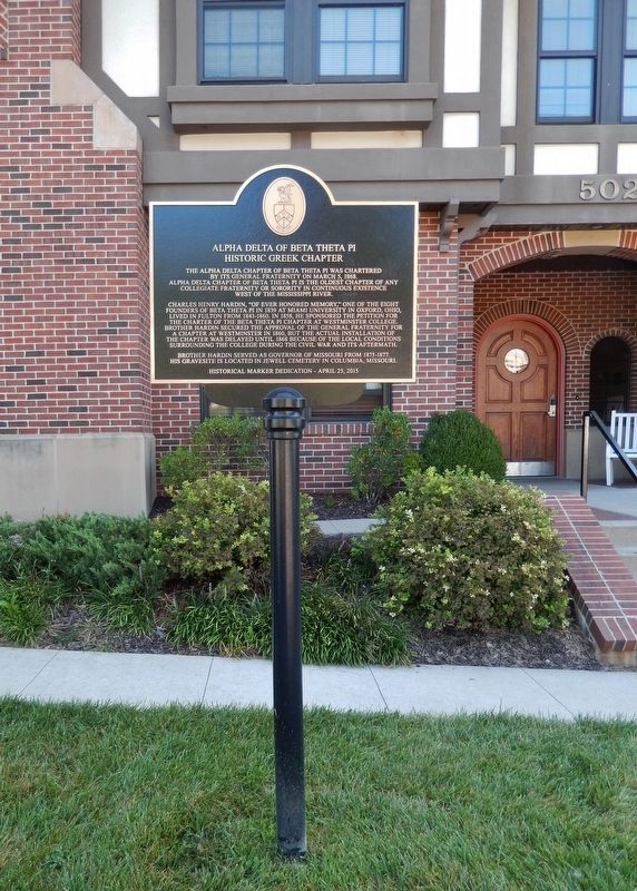
The Alpha Delta Chapter of Beta Theta Pi was chartered
by its General Fraternity on March 5, 1868.
Alpha Delta Chapter of Beta Theta Pi is the oldest chapter of any
collegiate fraternity or sorority in continuous existence
west of the . . . — — Map (db m119020) HM
Originally located on a bluff on Stinson Creek in northwest Fulton, about 200 yards north of the Boone's Lick Trail, this rock bears the name D. Boone with the date 1801 and an arrow pointing due west. — — Map (db m69693) HM
The Civil War divided Missouri, but in Callaway County more soldiers served with the pro-Southern Missouri State Guard (MSG), the Confederate Army or irregular partisans. The MSG was a state-sanctioned force, organized in May 1861 to defend . . . — — Map (db m70386) HM
Sacred to the memory of
Captain James Callaway,
who sacrificed his life in the defense of his
country, and who fell in the same battle in which
McMullin, McDermid and Houchins were killed.
Captain James Callaway,
raised and . . . — — Map (db m70383) HM WM
With a 999-year lease from the Louisiana & Missouri River Railroad, the Chicago & Alton Railroad completed this line in July 1872. At one point, the “South Branch” ran from Mexico to Cedar City, with passenger service to Fulton beginning in 1872 and . . . — — Map (db m252713) HM
Awarded a National Historic Designation in 2007, The Court
Street Historic Residential District begins on 10th Street and
continues to Fulton's historic downtown. The tree-lined streets
compliment 83 homes of varying architectural styles, many . . . — — Map (db m252718) HM
This is a two sided markerSide A:
Fulton was founded here in the Little Dixie Region of Missouri, 1825, to replace the poorly located Elizabeth as seat of Callaway County. Named for a grandson of Daniel Boone and War of 1812 . . . — — Map (db m78757) HM
In 1916, forty Fulton businessmen decided to create a country club. They purchased forty acres near town from the estate of Mrs. Elkanah Smith. Renovations, which were supervised by General M.F. Bell, transformed the Smith farmhouse, originally . . . — — Map (db m207735) HM
When former Confederate president Jefferson Davis accepted an invitation to speak at the Callaway County agricultural fair ten years after the Civil War, he knew that he would be coming to a community with many Southern sympathizers and former . . . — — Map (db m252724) HM
Dedicated in 1922 to the Soldiers, Sailors & Marines of Callaway Co. who served their country in the World War of 1917-1918 and whose names now appear on bronze tablets in the Callaway Co. Court House.
This ground was acquired in 1921, through . . . — — Map (db m69665) HM WM
Dedicated to the highest principles, President Robert L. D. "Larry" Davidson was a leader of character during times of both prosperity and adversity. As the 15th president of Westminster College, Davidson passionately invested in students, . . . — — Map (db m70395) HM
Rev. William W. Robertson, (1807-1894), Presbyterian minister and educator, established Fulton Female Seminary (1850) on W 7th Street, originally known as Seminary Street. Rev. Robertson founded Westminster College in 1853. — — Map (db m70423) HM
Following the defeat of Nazi Germany in 1945, the country was divided into four zones of occupation by the World War II Allies. The United States, Great Britain, France and the Soviet Union. Berlin, located deep within the Soviet zone also was . . . — — Map (db m59080) HM
Commemorates Churchill's "Iron Curtain" speech delivered at Westminster College, Fulton, Missouri on March 5, 1946, in which he warned:
"From Stettin in the Baltic to Trieste in the Adriatic an IRON CURTAIN has descended across the Continent. . . . — — Map (db m59085) HM
The Church of St. Mary Aldermanbury first mentioned in 1181, destroyed by the Great Fire of London in 1666, rebuilt by Christopher Wren, destroyed by bombing in 1940. The remaining fabric removed to Westminster College in 1966 and restored as this . . . — — Map (db m59087) HM
"The Columns" atop this hill are the venerated remains of Westminster College's original academic building, Westminster Hall, destroyed by fire in 1909. Founded in 1851, Westminster was one of the few Missouri colleges to function in some fashion . . . — — Map (db m70437) HM
This gun was placed here by Callaway Post 2657, Veterans of Foreign Wars of the United States, and the City of Fulton, in honor of the Callaway men and women who served their country in all of its wars. — — Map (db m69667) WM
In honored memory of those from Callaway County who gave their lives in the service of our country. They joined an unbroken line of patriots who died, that liberty, freedom and justice might live and grow.
Erected May 29, 1989
[Rolls of . . . — — Map (db m69691) WM
"A reminder of the historic past and a symbol of strength for the future."
The Columns of Old Westminster Hall, built in 1858, preserved after the Fire of 1909, repaired by the Class of 1927 and rebuilt in 1972 by many loyal alumni. . . . — — Map (db m70419) HM
In memory of
William Chrisman Swope
1878 - 1909
Graduated from Westminster 1900
Faithful to every duty, self-sacrificing and helpful. A loyal officer in his church, a sincere and devout Christian
————— . . . — — Map (db m70421) HM
In this building
5 March 1946
the Right Honorable
Winston Churchill
Wartime Prime Minister of
Great Britain
delivered his
"Iron Curtain" Speech
having been introduced by
Harry S. Truman
President of the
United . . . — — Map (db m70417) HM
Cole County, Missouri
Established November 16, 1820
Dedicated in this bicentennial year to those who have given life to Cole County, from the generations of Ancient Ones before the settlers of European and African lineage who formed our . . . — — Map (db m169397) HM
1826
Cedar City's Prosperity
The town Hibernia exists in post office records from 1825. A wilder and wider Missouri River was a half mile closer then, and many people arrived by steamboat. While laying out a new town in 1872, David Kenney . . . — — Map (db m169401) HM
Missouri State Capitol and Museum
The Missouri State Capitol, built in 1918 of Carthage marble and standing 262 feet high, is a majestic site. On the first floor is the Missouri State Museum with one wing dedicated to the history of . . . — — Map (db m169402) HM
Here at the North Jefferson Trail Head, on Sept. 29, 1996, the east and west sections of the Katy Trail were joined, forging the final link uniting St. Charles and Sedalia via Katy Trail State Park. — — Map (db m169404) HM
Missouri was a beginning and end for the Lewis and Clark Expedition. Planned by President Thomas Jefferson and carried out by the two captains and a large crew, the expedition is a keystone American event. When the United States took ownership of . . . — — Map (db m169398) HM
From the time of the Louisiana Purchase and the expedition of Lewis and Clark, the 19th century saw Missouri and the nation journey from a rural frontier to an urban industrialized society. The dawn of the 20th century saw the recognition of a . . . — — Map (db m169403) HM
The distance from North Jefferson to Hartsburg is 10.4 miles. The trail passes through Claysville (milepost 149.8) and crosses Turkey, Cedar and Slate creeks. Bluffs are on the right side and a wide variety of habitats including farms and . . . — — Map (db m169399) HM
The distance from North Jefferson to Tebbetts is 12 miles. The trail passes through Wainwright (milepost 137.6), which was named after a St. Louis financier who helped establish the Missouri, Kansas & Eastern Railroad, later part of the Katy. . . . — — Map (db m169400) HM
The list of recorded floods on the Missouri River is long, but the most devastating in recent history was the Great Flood of 1993. The river at Jefferson City crested more than 15 feet above flood stage. Throughout the Midwest that year, two . . . — — Map (db m169406) HM
Kingdom City's name alludes to the Kingdom of Callaway. How Callaway County came to be called a kingdom is a story dating to the early months of the Civil War.
In Fall 1861, the Union controlled the St. Louis area but the rest of the state . . . — — Map (db m299140) HM
1818.........
Smith's Landing
Thomas Smith, a private with Callaway's Rangers, founded a
small town along the Missouri River in 1818. The town, dubbed
Smith's Landing, was based around steamboat commerce. In
addition to goods being . . . — — Map (db m252810) HM
The Missouri-Kansas-Texas
Early in 1870, Judge Levi Parsons, head of the Union Pacific
Southern Branch, called a meeting. He announced his
plans to be the first railroad to reach the Indian Territory
bordering Kansas. The “Missouri River, . . . — — Map (db m252799) HM
The distance from Mokane to Portland is 9.1 miles.
This segment of Katy Trail State Park has several outstanding
sights, including an impressive railroad bridge, close-up views of
the Missouri River and the geologic oddity of Standing Rock.
. . . — — Map (db m252797) HM
The 6.2 miles from Mokane to Tebbetts have
changed little since the early days of the Katy Railroad.
Like Tebbetts and many other towns along the trail,
Mokane was established as a railroad town. Its name
comes from this line's builder, the . . . — — Map (db m252735) HM
Standing Rock looks like an isolated boulder that fell from above, but it is actually a remnant of the bluff that has resisted erosion. The rock is a fine-grained sandstone that may have formed when sand filled in a sinkhole or joint within . . . — — Map (db m272493) HM
The Portland-McKittrick segment is 15.1 miles long.
Bottomland forest, islands and channels of Tate Island
Conservation Area – which is accessible only by boat – can
be seen to the right of the Katy Trail between mileposts 114.5
and 112. A Lewis . . . — — Map (db m252816) HM
The distance from Portland to Mokane is 9.1 miles.
This segment of Katy Trail State Park has several outstanding
sights, including an impressive railroad bridge, close-up views
of the Missouri River and the geologic oddity of Standing Rock.
. . . — — Map (db m252820) HM
"Several rats of Considerable Size was Cought in the woods to day—Capt Lewis went out to the woods & found many curious Plants & Srubs, one Deer killed this evening"
William Clark, May 31, 1804
Attack on Côte Sans Dessein
A settlement on the Côte Sans Dessein hill weathered an attack by members of the Sac and Fox Nation on April 4, 1815. The battle was an extension of the War of 1812 (1812-1815), though a treaty to end the fighting . . . — — Map (db m272492) HM
Big Business on the Missouri River
The fur trade was a booming business in the wilderness west of St. Louis. Trapping primarily took place on the upper Missouri River in the Dakotas and Montana. Furs were then sent down the river to St. Louis . . . — — Map (db m121229) HM
1808…
A Hill Without Design
Cote Sans Dessein, French for "hill without design," stands near Tebbetts on the banks of the Missouri River. The hill is notable for (and gets its name from) the fact that it stands alone, separate from . . . — — Map (db m272665) HM
Williamsburg and its rural neighborhood, including the Loutre River valley to the east, were home to several famous, even notorious Southern guerrillas.
One such was Capt. Alvin Cobb of "Cobbstown," in western Montgomery County, Mo. A large, . . . — — Map (db m212623) HM
Presented and placed atop the
Carroll County Courthouse
when building was erected 1902-1903
Removed in 1953 -- Erected this location
as a historical landmark in 1970
by the County Court. — — Map (db m90892) HM
Born in County Tyrone · Ireland
May 10-1810
Died in Ottumwa · Iowa
June 1-1879
Soldier · Jurist · Statesman
United States Senator from
Illinois · Minnesota and Missouri
Cerro Gordo · Chapultepec
Winchester · Port Republic
Erected by . . . — — Map (db m90874) HM WM
Born in County Tyrone, Ireland
May 10, 1810
Died June 1, 1879
Rests in St. Mary's Cemetery near
Carrollton, Missouri
Soldier · Statesman
Jurist · Patriot
Brigadier General
Mexican War · Civil War
Cerro Gordo · Winchester . . . — — Map (db m90890) HM WM
On Oct. 24, 1838 about 800 Potawatomi Indians camped near Carrollton on forced emigration from Indiana to Kansas. Cold was intense on the prairie. — — Map (db m198474) HM
Fort Orleans, first European post in the Missouri Valley, was built by the French explorer Etienne Véniard De Bourgmond on the Missouri River close by, a few miles above the mouth of the Grand, 1723-24. The exact location of the fort is not . . . — — Map (db m132000) HM
On Oct. 23, 1838, about 800 Potawatomi Indians camped near here on the forced removal from Indiana to Kansas. They camped at Thomas' encampment. Having marched 10 miles after ferrying the Grand River. Wet bottom lands and severe cold made the march . . . — — Map (db m198473) HM
The World's Largest Pecan was built by George and Elizabeth James, in 1982. It was a tribute to a large, hardy, northern pecan that they found on their farm, James Pecan Farm, Inc. in the early 1950's. This patented nut, the starking hardy giant, . . . — — Map (db m198479) HM
On Oct. 22, 1838, about 800 Potawatomi Indians began ferrying the Grand River as they walked from Indiana to Kansas on the forced removal. By dark all the Indians and many of the wagons were over the river and ferried the rest the next day. — — Map (db m198471) HM
Born in Prince Edward County, Virginia September 11, 1809 Resided in Chariton County Missouri 1831-1865 Speaker Of the House of Representatives Of Missouri General Assembly 1840-1844 Elected to Congress 1844 Participated in War with Mexico 1846-1848 . . . — — Map (db m131899) HM WM
Founded, 1832, by Englishman James Keyte, Keytesville is the judicial seat of Chariton County. First seat of the county, organized in 1820, was "Old" Chariton laid out, 1817, near the mouth of the Chariton River by Duff Green, editor, politician. . . . — — Map (db m131898) HM
With the faith and courage of
their forefathers who made
possible the freedom of these
United States
The Boy Scouts of America
dedicate this copy of the
Statue of Liberty as a pledge
of everlasting fidelity and
and loyalty
40th . . . — — Map (db m89550)
Ten mineral springs were brought together in this building in 1935 under WPA project #5252 on the site of the original spring. The cost was more than one million dollars. The Hall of Waters houses City Hall and host the world's longest mineral . . . — — Map (db m90755) HM
All of the mineral springs brought together in this building in 1935 under W.P.A. on the site of the original spring. The cost was more than one million dollars. It is unique with the world's longest mineral water bar. — — Map (db m162679) HM
In 1824, William Allen, of Howard County, Missouri, applied for and received a land patent for the original 80 acres of land and later purchased additional land where the Atkins-Johnson Farm is today. Soon after, 130 acres of the land was sold to . . . — — Map (db m252138) HM
Log house of two rooms built by J.Z. Atkins in 1826 on an original land grant. Remodeled during the 86 years in this family. One of the county's best-preserved pioneer houses. Home of the Johnsons since 1922. — — Map (db m252136) HM
The initial inhabitants of Gladstone were Native Americans of the Missouri Osage, Blackhawk, Fox and Sac tribes. The first settlers came from Kentucky, Tennessee, Virginia and South Carolina. In the 1880's, W. E. Winner bought three 80-acre farms, . . . — — Map (db m252139) HM
Old Pike Road is the oldest, most westerly, north-south road in Clay County. Starting at Kawsmouth on the north bank of the Missouri River in Harlem it ran north, skirting on the east an old river scar the settlers called “the slough bank,” until it . . . — — Map (db m252107) HM
Platte Purchase Drive marks the site of the western border of the United States from 1821, when Missouri became a state, until 1837. Unlike today, the western border of Missouri was a straight line north from the confluence of the Missouri and . . . — — Map (db m252142) HM
"The Antioch Congregation was organized as a Christain Church (Disciples of Christ) in September 1853 by Moses Easterly Lard (1818-1880), Pastor of the Liberty Christain [sic] Church in Missouri. Its first 'Meeting House', a one room building, and . . . — — Map (db m86636) HM
Congregation established in 1853 by Rev. Moses E. Lard as Christian Church. Building constructed 1859. Has served since as worship and social center. Reorganized as Community Church 1930. Building moved and [illegible] by Antioch Church Historical . . . — — Map (db m86639) HM
Congregation formed in 1853 as Antioch Christian Church.
This building erected in 1859. Restored by Antioch Community Church Historical Society, organized December 1964 with Hugh P. Loughrey founding president.
[Additional plaque . . . — — Map (db m86640) HM
dedicated cemetery dating to the earliest days of Clay County. Many pioneers are buried here including James Crowley, a Revolutionary soldier. — — Map (db m140837) HM
This historic aviation facility is named in honor of longtime medical pathologist, Jackson County coroner, judge, and Mayor of Kansas City, Missouri, Charles B. Wheeler. In appreciation of his dedication to air service expansion for the people of . . . — — Map (db m58406) HM
In 1927 led the city's airport development program and personally laid the framework for the network of air transport routes which today make Kansas City the Air Hub of the Nation. — — Map (db m58407) HM
Homeplace settled by Elbridge Arnold in 1838, home built in 1856. Family home of William A. Crouch 1922 until it became the home of Edwin Yancey Crouch in 1940. — — Map (db m49819) HM
Dedicated
September 26, 1993
to the memory of
Howard Porter
October 1, 1916 • March 9, 1945
WWII Army Air Force Veteran
Killed in Action March 9, 1945
"Greater love than this, no man hath,
than that he lay down . . . — — Map (db m287126) WM
Home of Rev. Robert James, Baptist minister who came here in 1840. Son Jesse was born here and with his brother Frank, were involved with the Bushwhackers in criminal escapades until Jesse was killed in 1882. Frank surrendered and lived with his . . . — — Map (db m59638) HM
This farm established by Walthus L. Watkins, centered around his woolen factory built 1860-1861. It operated for 40 years with mass production machines. This farm (Bethany) also boasted a grist mill, flour mill and saw mill, church and octagonal . . . — — Map (db m46134) HM
Mount Olivet Cemetery was established
in 1868 by pioneers who organized the
Mount Olive Church in the John Sleet Major
home on December 25, 1856.
The original church structure was built in the northwest corner
of Uriel Cave's field in . . . — — Map (db m287157) HM
On July 5th, 1836, Andrew Hixon and wife, Ann, conveyed by Warranty Deed to the "Town of Liberty" Trustees for $30, one acre, "for the purpose of a public burying ground". Used as such before the 1825 settlement of Liberty. "The Old Graveyard", . . . — — Map (db m68263) HM
This property
built in c.1894
has been placed on the
National Register
of Historic Places
by the United States
Department of Interior
1993 — — Map (db m68153) HM
This property
built in c.1880
has been placed on the
National Register
of Historic Places
by the United States
Department of Interior
1993 — — Map (db m68188) HM
This property
built in 1885
has been placed on the
National Register
of Historic Places
by the United States
Department of the Interior
1993 — — Map (db m68129) HM
This property
built in c.1875
has been placed on the
National Register
of Historic Places
by the United States
Department of Interior
1993 — — Map (db m68189) HM
This property
built in 1885
has been placed on the
National Register
of Historic Places
by the United States
Department of the Interior
1993 — — Map (db m68127) HM
This property
built in c. 1877;1915
has been placed on the
National Register
of Historic Places
by the United States
Department of Interior
1993 — — Map (db m68190) HM
This property built in c.1886
has been placed on the
National Register
of Historic Places
by the United States
Department of Interior
1993 — — Map (db m68157) HM
This property built in c.1875
has been placed on the
National Register
of Historic Places
by the United States
Department of Interior
1993 — — Map (db m68187) HM
While living on this site in the 1830's, Alexander Doniphan championed the Constitutional rights of an oppressed people to ensure their religious freedom. He helped create Caldwell County as a refuge for the Mormons in 1836 and refused to carry out . . . — — Map (db m68243) HM
Kate “Katie” Atchison Gordon Nelson (1877 – 1953)
Kate “Katie” Atchison Gordon Nelson was born in Liberty, Missouri in 1877. Descendants claimed that she told her family that her biological father was David Rice Atchison, the proslavery . . . — — Map (db m274429) HM
In September of 1861, Liberty and Clay County briefly became a focal point during the American Civil War in Missouri. Near this site, the Battle of Liberty was a decisive victory achieved by the pro-Southern Missouri State Guard against Union . . . — — Map (db m245595) HM
Built by Daniel Bell in 1858, an impressive ante-bellum mansion, restored by present owner, Donald Pharis, who also re-erected an early day log cabin here from nearby Richmond. — — Map (db m80964) HM
This property built in c.1895
has been placed on the
National Register
of Historic Places
by the United States
Department of Interior
1993
Formerly the Messick Hotel, was purchased by Sterling Price Boggess in 1902 and operated . . . — — Map (db m68155) HM
Jesse Dodd, Sr.
(1906-1992)
A Liberty entrepreneur, Jesse Dodd, Sr. was the son of Robert and Anna Belle Dodd, who settled in Clay County during the Great Migration from Bowling Green, Kentucky. Jesse completed his education at Garrison . . . — — Map (db m274075) HM
Fairview Cemetery/New Hope Cemetery
Fairview Cemetery was established in 1858 and so named because it overlooked what once were the community’s fairgrounds (to the south). Those fairgrounds were acquired by the City of Liberty in 1901 and . . . — — Map (db m273777) HM
"Not everyone can be famous but everybody can be great because greatness is determined by service. You only need a heart full of grace and a soul generated by love." - Dr. Martin Luther King, Jr.
In September 1948, the Clay County Horse Show Association needed a facility to host their annual shows. In cooperation with the Liberty Chamber of Commerce, they proposed) purchasing a 12 acre tract that would be deeded to the city as a park. In . . . — — Map (db m273027) HM
Jewell Hall was used as a hospital and barracks and this hill was fortified by Federal troops under Col. John Scott after their defeat at the Battle of Blue Mills Ferry, Sept. 17, 1861. A line of rifle pits was thrown up from the present location of . . . — — Map (db m45555) HM
1276 entries matched your criteria. Entries 101 through 200 are listed above. ⊲ Previous 100 — Next 100 ⊳