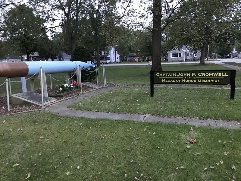
Medal of Honor citation
For conspicuous gallantry and intrepidity at the risk of his life above and beyond the call of duty as commander of a submarine coordinated attack group with flag in the U.S.S. Sculpin, during the ninth war patrol of . . . — — Map (db m183533) WM
[Front plaque]
Peace time or war time
we honor all Henry area
residents who have served
in the armed forces of the
United States of America
[Left wall]
1961 1975
Cecil E. Altizer • Joann M. Altizer • Harry . . . — — Map (db m183515) WM
U.S. Navy submarines paid heavily for their success in World War II. A total of 374 Officers and 3,131 men are on board these 52 U.S. Submarines still on “Patrol”.
Albacore, Amerjack, Arconaut, Barbel, Bonefish, Bullhead, Capelin, . . . — — Map (db m92808) WM
U.S. Navy submarines paid heavily for their success in World War II. A total of 374 officers and 3131 men are on board these 52 U.S. submarines still on "patrol."
Albacore • Amberjack • Argonaut • Barbel • Bonefish • Bullhead • Capelin • Cisco • . . . — — Map (db m183535) WM
You are standing looking at shaft #1 of Devlin Coal Company. This view is from the slag pile looking down. Today, it is hard to visualize just how massive and important the Devlin/Toluca Mining Operation was.
After Bennington Township was . . . — — Map (db m252953) HM
This large concrete structure, one of two remnants of the Devlin Toluca Mine left today, was essential to the miners as it housed the fan for ventilation into the mine shaft. Using the latest in ventilation and fresh air systems made Toluca's Mine . . . — — Map (db m252950) HM
From Farmland to the City of Toluca
In 1887, farmers in Bennington Township of Marshall County were having great difficulty marketing their grain and livestock by horse-drawn wagons to Streator, Peoria or Bloomington. Family diaries even . . . — — Map (db m252916) HM
The Jumbo are a pile of slag, which is coal waste, rock, or gob. They are a landmark of the Longwall mining era and are memorials to the region's coal industry, its workers, and a symbol of Toluca. This symbol at one time stood over 151 feet. To . . . — — Map (db m252958) HM
Only a few remnants of the Toluca Coal Mine still exist today. One of these is this concrete rectangle. During the mining operation, this was a water reservoir used to cool the steam engines. A 6-inch diameter pipe carried water from the open well . . . — — Map (db m252978) HM
In 1893 the Sante Fe Railroad authorized
Charles Devlin, their manager of mining
properties, to purchase the mineral rights
here to 11,000 acres. The Devlin Coal Company
sank two shafts and began producing coal
using the longwall method, . . . — — Map (db m33669) HM
Jubilee College was founded by Bishop Philander Chase to train
Episcopal ministers for service in the frontier West. Chase's
ambitious plans called for a large Gothic Revival-style building
to serve the men's college and theological seminary. . . . — — Map (db m150539) HM
Lazarus Levi Guyer built this two story log house. The first floor was a general store and public meeting place. The second floor was his home.
• First Sunday school
• First town council meetings
• First Methodist Episcopal Church
• . . . — — Map (db m308651) HM
★ ★ 1917 — 1919 ★ ★
These men of Brimfield, Ill. served their country in World War No. I
William Fughs •
Ward E. Harkers •
Joe B. Slocum •
W. U. Littlefield •
Henry A. Arnold •
Lester W. Rusk •
Walter . . . — — Map (db m308665) WM
Founded by the Rt. Rev. Philander Chase, first bishop of Illinois, 1845. Restored and rededicated by the Rt. Rev. William L. Essex, Bishop of Quincy Nov. 4, 1945. — — Map (db m150540) HM
This church was erected in 1845 by Bishop Philander Chase who founded Kenyon and Jubilee colleges 'He raised these hallowed walls; the prairies smiled and paradise was opened in these wilds!'
Restoration work in 1945 was made possible by the . . . — — Map (db m308673) HM
Gomo or Masemo (Resting Fish) (b. ca. 1750- d. 1815), a Potawatomi leader, respected by members of many tribes, the residents of French Peoria, governor of the Illinois Territory Ninian Edwards, and William Clark, then U.S. agent for Indian . . . — — Map (db m308005) HM
Migration along the river
Here on the banks of the Illinois River, you can witness two key migrations. Each year, thousands of barges carry grain, coal, chemicals, and other products up and down the Illinois River. Since 1862, when the I&M . . . — — Map (db m183541) HM
Robert Gilmore LeTourneau (usually referred to as R.G.) was known as the
“dean of earthmoving” and “God's businessman.” At the urging of Caterpillar
Tractor Company, he moved his manufacturing business from California . . . — — Map (db m150578) HM
Jubilee College, two miles to the north, was established by Philander Chase, first Protestant Episcopal bishop of Illinois, as one of the state's early institutions of higher learning. First students were received in 1840, and the school . . . — — Map (db m309336) HM
Peace and Harvest were designed by Mary Anderson Clark as a Works Project Administration (WPA) art project. In 1938, a committee, chaired by Mrs. Julia Proctor White, commissioned Mary Anderson Clark to sculpt the eight-foot limestone . . . — — Map (db m253069) HM
Originally cast in Seville, Spain in December, 1776 as a field artillery piece. It was positioned within the walls of Manilla, Phillipines for approximately 100 years. The cannon was among artillery captured during the Spanish-American . . . — — Map (db m253076) HM
This site was settled by John Armstrong, a native of
Cincinnati, who came to Peoria in 1836. Here, John and his
wife raised a family of thirteen children. The original
homestead was destroyed by fire. The house at this site was
built in 1857 by . . . — — Map (db m220256) HM
This historical marker has been placed here in honor of the proud alumni of the Bradley University Football team.
The program was initiated with the founding of Bradley University in 1897 and the team continued its commitment to the gridiron . . . — — Map (db m150588) HM
This plaque represents the location of the home plate on the former on-campus athletic field.
The athletic field was used for many purposes by the Braves, including the following: Varsity Baseball, Varsity Football, Varsity Track and Field, . . . — — Map (db m150585) HM
This tablet marks the site of Camp Lyon, where the following Illinois regiments of volunteer soldiers of the Civil War were encamped, from May 1861 to June 1864. Upon it are inscribed the dates of encampment and names of the colonels of the . . . — — Map (db m183558) HM
This tablet marks the site of Camp Peoria where the following Illinois regiments of volunteer soldiers of the Civil War were encamped from Aug 1862 to Nov 1862. Upon it are inscribed the dates of muster into the United States service and the names . . . — — Map (db m183621) WM
This house, one of the earliest on High Street, was built
by Mr. Erastus D. Hardin about 1859. The Hardins, a
socially prominent and active family, occupied the
house until 1904, a period of about 45 years.
Upon his arrival in Peoria in 1857, . . . — — Map (db m220266) HM
This cross recalls to the passer-by the historic journey of Father Marquette and Louis Jolliet and their brave companions who camped on the banks of Lake Peoria
August 1673
(inscription on ground:)
This monument was erected by . . . — — Map (db m268278) HM
Frank Lloyd Wright At the turn of the century, many American architects, strongly influenced by the Beaux Arts style – a combination of European Revival architectural patterns dominating the Chicago Columbian Exposition of 1893 – simply . . . — — Map (db m220269) HM
George Washington Carver Community Center fulfills the legacy of black women who believed in the motto "lifting as we climb."
The Colored Women's Aid Club was part of a rich network of women active in the social reform and social welfare . . . — — Map (db m267235) HM
Julia Ballance House This house was constructed for Julia Schnebly Ballance in 1885 when she was sixty-nine years of age. Julia Schnebly came to Peoria with her parents in 1835 from Maryland. Shortly thereafter she married Charles Ballance, an . . . — — Map (db m220221) HM
Marker Front
During World War II the Wisconsin-based Manitowoc Shipbuilding Company constructed twenty-eight Gato Class fleet submarines. These boats, dubbed “Freshwater Submarines”, bolstered the production of existing naval . . . — — Map (db m9206) HM
We, the living, dedicate the trees on this campus in memory of the former students of Woodruff High School who gave their lives in defense of their country.
Dedicated - April 24, 1959 — — Map (db m290906) WM
Main Text in Center Brass Plaque
In Honor of the men and women who have served their country in the armed services of The United States
Duty Honor Country
With the exception of the above inscription, the brass . . . — — Map (db m9323) HM
This plaque dedicated by
Colonel John C. Bryner, Camp 67
Sons of the Union Veterans of the Civil War
in memory of veterans interred in Moffatt Cemetery
Veteran • Rank • Co. • Regiment
Amsler, Henry Pvt G 14 IL Inf Cons • Anderson, . . . — — Map (db m239257) WM
Moss-High Historic District Moss Avenue and High Street which meet at their
intersection with Sheridan Road contain a remarkable
variety of residential structures significant in terms of
the history they represent and of the architectural . . . — — Map (db m220267) HM
Nance Legins-Costley is known to history as the first enslaved person
Abraham Lincoln helped free. She was born in 1813 into indentured
servitude in Kaskaskia, Illinois Territory, to slaves Randol and Annachy
Legins. In 1827 in Springfield, . . . — — Map (db m239256) HM
In the fall of 1999, a small group of county officials and area citizens met to discuss the long overdue need to honor the nearly 30,000 Peoria County Veterans that served in the United States military during World Wars I & II and to recognize over . . . — — Map (db m268276) HM
Peoria County Veterans who lost their lives in the line of duty during World War One
James D. Abel • Ernest L. Ahlstrand • Edwin Allen • Raymond B. Allen • Chester A. Anderson • Arthur W. Arnold • Eldie O. Bailey • Harold L. Baldwin • . . . — — Map (db m268073) WM
Marker Front:
Peoria on The Riverfront
The Illinois River is the Major Waterway within Illinois Boundaries. Native Americans are known to have lived along its banks for 11,000 years.
1673 Along this riverfront Frenchmen . . . — — Map (db m9178) HM
When Father Marquette, the missionary, and Louis Joliet, the trader, first white men to see the site of Peoria, came ashore here in the summer of 1673, there was an Indian village at this location. 100 years later, the French had built a village . . . — — Map (db m183623) HM
The city of Peoria was named for the Peoria tribe of the Iliniwek Indian confederacy who once lived here. It was in 1673 that Jacques Marquette and the explorer Louis Jolliet traveled through the widened portion of the Illinois river known as Lake . . . — — Map (db m150580) HM
Near this marker, Charles A. Lindbergh landed his de Havilland biplane on the St. Louis Chicago mail run 1926-1927 prior to his transatlantic flight. — — Map (db m150582) HM
This monument, reportedly one of the first public Civil War monuments of its kind in the State of Illinois, originally dedicated on October 11, 1866, stood on the Peoria County Courthouse Square until dismantled in 1962 to make way for the new . . . — — Map (db m290909) HM
This portion of Armstrong Avenue is the only remaining brick boulevard combination left in the city of Peoria.
The John Armstrong Family came to Peoria in 1836, and the family farmhouse still stands at 303 West Armstrong. John Armstrong . . . — — Map (db m220259) HM
Aquilla Moffatt arrived here in 1822 and began mining and milling ventures.
On return from the Black Hawk War, he built his home on South Adams
Street and set aside a small burying ground for family and friends. After
the Civil War he named an . . . — — Map (db m239258) HM
Meaning "fat lake," Illinois Indian name for Peoria Lake. Here passed Jolliet and Marquette in 1673. Established near the lake were Ft. Crévecoeur, 1680; Ft. St. Louis, 1691-92; Old Peorias Fort and village, 1730; Peorias, 1778; Ft. Clark, 1813; . . . — — Map (db m309742) HM
Pulsifer's Grove Prior to his arrival in Peoria in 1856, Sidney
Pulsifer acquired a large, undivided parcel of real
estate on the Middle Bluff, bounded roughly by
North Street and Knoxville Avenue, and by
Columbia Terrace and State Street. . . . — — Map (db m220253) HM
Captain Zeally Moss is buried in the
Bradley family circle, with his daughter
Lydia Moss Bradley in the Mt. Prospect
area at the southeast corner of the
cemetery. He was born in Loudoun County,
Virginia. on March 6, 1755, the son of
Nathaniel . . . — — Map (db m220299) HM WM
Lt. John Dusenberry died in Peoria
County, Illinois, on September 26, 1833.
He was buried in the 'Old French Cemetery'
which became Block 35 when the Town
of Peoria was formed in 1835.
Descended from mid-1600s immigrants
from the . . . — — Map (db m259405) HM WM
Known as Powell Press Building
This building, the oldest Commercial structure on Peoria's Riferfront, was saved, moved, and restored by City of Peoria. — — Map (db m9180) HM
Circa 1499 - This bur oak takes root.
c. mid/late 1600's - French explorers tour this region inhabited by Peoria Native Americans.
c. 1750's - Early surveys by European setters include reference to this tree.
c. 1850's - Dr. & . . . — — Map (db m220260) HM
This plaque is dedicated to the memory of George Henry Ellis, a navy hero who was born in Peoria, Illinois on October 26, 1875. Chief Yeoman Ellis was serving on board the flagship USS Brooklyn during the blockade of the Spanish squadron docked . . . — — Map (db m268279) HM
Founded August 4, 1854
This property is listed in the
National Register
of Historic Places
by the United States
Department of the Interior
2004 — — Map (db m220302) HM
Norman Purple d.1863 Peoria attorney and judge; appointed Justice of the Illinois Supreme Court in 1846; compiled the general statutes of the state, known as the Purple Statutes. Vista Hill F3
Charles Ballance d.1874 Pioneer . . . — — Map (db m185720) HM
Susan Goodman Komen wanted to make the world a better place. The active civic leader, daughter, sister, wife and young mother of two from Peoria, Illinois, left a legacy she never imagined — her life changed the way the world talks about and . . . — — Map (db m306508) HM
Tobias Bradley, a Mississippi River produce merchant,
married Lydia Moss of Switzerland County, Indiana in
1837. Ten years later they came to Peoria. This house
constructed in 1856 became the home of Lydia and
Tobias Bradley in 1858. After . . . — — Map (db m220298) HM
This fountain and others identical to it were
commissioned by Sara Hall Easton to honor
her husband Edward S. Easton, a wealthy grain
dealer and distiller, upon his death in 1901.
The Eastons built and lived in the stately mansion
to your . . . — — Map (db m220265) HM
The Gipps Brewing Co. Andrew Eitle established the first brewery in Peoria c.1836-7 on Lot 1, Block 49, Bigelow and Underhill's addition, currently the S.W. corner of Water and Franklin Streets. This brewery operated under several names until . . . — — Map (db m220223) HM
The Peoria Grain Trade Early Peoria commercial enterprises were
established on a broad agricultural base. Distilling,
cattle marketing, leather processing, and farm
machinery manufacturing in turn rose to prominence.
Until the availability . . . — — Map (db m220258) HM
After the Civil War, increasing congestion in the valley
finally forced expansion to the bluff. This dynamic new
growth was fueled by the courage and enterprise of
men such as Henry R. Woodward. Responding to
growing demands for public services, . . . — — Map (db m220273) HM
World's Most Beautiful Drive
On October 12, 1910, President Theodore Roosevelt was driven along Grandview Drive to the Country Club of Peoria, where he attended a luncheon. When his host apologized for the bumpy road conditions, Roosevelt . . . — — Map (db m308775) HM
This marker commemorates two Revolutionary War veterans, Phineas Bronson and John Montgomery, who lived and died in Princeville, Illinois.
Phineas Bronson was born in Enfield, Connecticut on Nov. 9, 1764. He served in the 3rd Company of the 2nd . . . — — Map (db m150577) WM
At the end of the nation's most famous senatorial campaign between
Abraham Lincoln and Stephen A. Douglas, both men appeared on these
courthouse grounds to address the excited citizens of Stark County in
1858. Douglas arrived on October 26 and . . . — — Map (db m150575) HM
In
1680
upon this spot stood
Fort Crevecœur
built from the plans of
Robert Cavelier Sieur de La Salle
Here was centered the hope of
Louis XIV
for a broader empire of the French
on American soil
From here in 1680 went forth . . . — — Map (db m220305) HM
Ferries provided the earliest transportation across the river. In 1849, a toll bridge was completed across the river in the area of the Michel Bridge to your left.
The Franklin Street Draw Bridge began operation in 1912. It was replaced by the . . . — — Map (db m220195) HM
You are standing on the site of Wallace Station, a coal-fired power-generating plant operated by Central Illinois Light Company (CILCO).
The facility provided electricity to an area centered around Peoria. The plant began operating in 1925 and at . . . — — Map (db m220190) HM
The Peoria riverfront reflects the development of this area from its earliest days.
Still visible are the 1899 Rock Island Railroad station, warehouses, banks and commercial buildings. The gazebo with flags commemorates the 75th anniversary of . . . — — Map (db m220186) HM
[Main monument]
Dedicated to all men and women
wounded in all our wars
My stone is red for
the blood they shed.
The medal I bear
is my country's way
to show they care.
If I could be seen
by all mankind
maybe peace will . . . — — Map (db m220217) WM
The first passenger train came to Peoria in November 1854 on what became known as the Rock Island line. By 1920, Peoria had 15 railroads offering freight and passenger service from three railway stations and more than 100 trains a day through the . . . — — Map (db m220211) HM
The Illinois River served as the first highway through this area, bringing the earliest settlers, whether by canoe, or dugout, longboat or flatboat. Beginning in 1829, steamboats increased the flow of passengers and goods. Just south of here, the . . . — — Map (db m220210) HM
In 1837, James Pendergast bought this lot in Mackinaw at what was then the intersection of Monroe and Market Streets. In 1843, he began hauling lumber from Pekin for an addition to the existing home, which when completed would become a one and a . . . — — Map (db m308465) HM
William E. Aupperle, rotarian designed and built this structure donated by the Morton Rotarians in 1976.
Dedicated to his memory 1901-1986 — — Map (db m309395) HM
One of 175 Civil War regiments that gave African-American men the
chance to fight for the Union, the 29th U.S. Colored Infantry was
organized April 24, 1864, and dismissed Nov. 6, 1865. With 2072 men from
Illinois, Missouri and Wisconsin, it was . . . — — Map (db m253003) HM
The manufacture of organs was begun by John L. Hinners in 1879. The first work shop was in an upstairs room at 341 Court Street. Through the years there were partners in business: J.J. Fink 1881-1885, U.J. Albertsen 1895-1902. The business was . . . — — Map (db m267238) HM
Nance Legins-Costley of Pekin and her three eldest children were the first
enslaved persons Abraham Lincoln helped free. Nance was born in 1818 into
indentured servitude in Kaskaskia, Illinois Territory. She was sold in 1827 in
Springfield to . . . — — Map (db m253036) HM
William Henry ‘Bill’ Costley was the oldest son of Benjamin and Nance (Legins)
Costley and was born 1840 in Pekin. Born into indentured servitude with his two
older sisters Amanda and Eliza Jane, they and their mother had their freedom
confirmed . . . — — Map (db m253035) HM
On July 5, 1918, the steamboat Columbia sank upstream
from this spot near what was then Wesley City. What began
as one of the season's premier social events ended in tragedy.
The Pekin South Side Social Club sponsored the . . . — — Map (db m253050) HM
On June 25, 1862, the Union League of America was founded at Pekin, Illinois, to promote patriotism and loyalty to the Union. Its members hoped to counter northern disillusionment with President Lincoln's military policies after early Union . . . — — Map (db m267236) HM
Abraham Lincoln attended court in the fine two story rectangular brick courthouse with four Grecian columns and copper dome on this site. Here in 1842 he was challenged to a duel by James Shields. Lincoln last spoke here August 30, 1858. — — Map (db m12184) HM
Abraham Lincoln, our 16th President, spent much of his adult life balancing his legal practice with politics. His trips to the Metamora Courthouse where he practiced law often took him through Washington. He became acquainted with many Washington . . . — — Map (db m306888) HM
First President of the United States of America, served from 1789 to 1797 and was the dominant military and political leader of the United States from 1775 to 1799. He led the American victory over Great Britain in the American Revolutionary War . . . — — Map (db m306887) HM
The devastation from the tornado that struck Washington on November 17, 2013 was immense. But so was the response by so many that came to help our town.
We would like to recognize the following groups and individuals who helped financially to . . . — — Map (db m307257) HM
This is the site of Leather Works, the cobbler shop of Henry F. ('Heini') Ganzhorn during the late 1950's and into the 60's, faithfully serving the community he dearly loved. Prior to that, his business was located on the Washington Square. His . . . — — Map (db m307158) HM