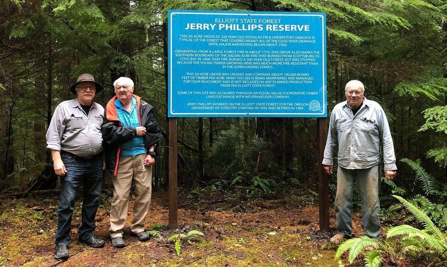
This 50-acre grove of 250 year-old Douglas-fir & understory hemlock is typical of the forest that covered nearly all of the Coos River drainage until major harvesting began about 1950.
Originating from a large forest fire in about 1770, . . . — — Map (db m237648) HM
From this vantage point on September 26th, 1936 you could hear the roar and feel the crushing heat of the flames as they swept across the city of Bandon. Lives were lost and 484 buildings burned to the ground. There were survivors. They surveyed the . . . — — Map (db m176955) HM
This lighthouse, officially the Coquille River Lighthouse, stands today as a reminder of a past era when safe shipping depended on a lightkeeper and his light.
From within the stuccoed brick walls of the adjoining 47 foot tower was a fixed, . . . — — Map (db m113914) HM
In the year 1874 on this and adjoining
property Captain Judah Parker and
partners built and operated the first
steam sawmill and steam tug on the
Coquille River. A year later Captain
Parker, with the assistance of the
settlers and farmers . . . — — Map (db m73228) HM
Donated by Menasha Corporation
To the City of Coos Bay
340 years old, 210 feet tall
Logged by: LA Logging Inc.
Tree Faller: Silver Creek Logging
2000 Trees Replanted
— — Map (db m114193) HM
On July 22, 1922 a fire started here and spread to both sides of Front Street. Within hours, 25 businesses had been completely destroyed. — — Map (db m114197) HM
Built in January 1946 by Great Northern Railway in St. Cloud, Minn., this steel-frame, wooden-sided caboose was put into service by the Spokane, Portland and Seattle railroad.
Originally painted red, caboose No. 853 operated on the . . . — — Map (db m113665) HM
This cupola-style, 54,000-pound steel caboose was built in December 1942 and sold to Southern Pacific for use on runs between Coos Bay, Eugene and Klamath Falls. Painted "all mineral" brown with daylight orange ends, it was among the last cupola . . . — — Map (db m113660) HM
The 27-foot tug named Irene was built in 1938 by a family friend, C.J. Sessions, for Henry Sause, Sr. and Curtis Sause.
It was designed along the lines of a Columbia River gillnetter with a four-cylinder, 40 horsepower Durant automobile . . . — — Map (db m114195) HM
Working On Water
Koos No. 2 was the second of several tugboats with the Koos name to work for the Knutson Towboat Company.
Built in 1924 by Frank Lowe at his Marshfield shipyard, Koos No. 2 went to work with her . . . — — Map (db m114186) HM
Lynching in America
Thousands of African Americans were the victims of racial terror lynchings in the United States between 1865 and 1950. Following the end of the Civil War, a wave of counterrevolutionary terror and violence swept over . . . — — Map (db m176959) HM
The tugboats of the Coos Bay waterways work on shipping related jobs of towing log rafts, moving big ships in and out of harbor, and moving barges.
Coos Bay is more than a port – it’s also an estuary. Estuaries are places where . . . — — Map (db m114184) HM
The Devon privateer took his flotilla from Plymouth Harbor August 5, 1577 bound for the River Plate.
He raided Spanish shipping and treasure houses around South America, including Valparaiso, Peru and Acapulco roads.
June 5, 1579 the renamed 78 . . . — — Map (db m114250) HM
The Coos Bay Lumber Co. purchased this 73-ton, 2-8-2 Mikado-type steam locomotive in 1922 from Baldwin Locomotive Works in Philadelphia, Penn.
Engine No. 104 pulled log trains – sometimes as many as 100 cars – from the Powers and . . . — — Map (db m113669) HM
January 25, 1951 Coos Bay, Oregon May 30, 1975 Eugene, Oregon American records held by Steve Prefontaine at the time of his death May 30, 1975: National Prep Record 2 Miles — 8:41.5, April 25, 1969, Corvallis, Oregon Outdoor 2,000 Meters . . . — — Map (db m157709) HM
Fire
On July 23, 1922 a fire destroyed more than twenty-five buildings on Front Street, including city hall.
Many of the businesses rebuilt a few blocks to the west, moving the heart of downtown Marshfield.
The fire was . . . — — Map (db m114151) HM
The shipping channel in the bay in front of you has a depth of about 35 feet at low tide. Large ships travel in this channel on their way to the upper bay.
Frequently small harbor tugs can be seen pulling log rafts by this pavilion. The . . . — — Map (db m114152) HM
Today, the Coos Bay harbor continues to serve as a connection to the rest of the world, and as a working waterfront.
In addition, it has become a source of identity for the people living near its waters.
The timber industry . . . — — Map (db m114153) HM
On the beach west of here the U.S. Transport Captain Lincoln was beached at high tide during a storm. The soldiers and crew built a camp from the sails under the trees across the bay from this spot and made a flag pole from a mast from which Old . . . — — Map (db m241038) HM
Travel by land was difficult until about 1915.
The road between Marshfield and North Bend was not completed until 1912. Most people continued to travel by small boats around Coos Bay for several more years.
Mosquito Fleet
. . . — — Map (db m114148) HM
Most travel was on water;
roads and rail lines were limited in the early days.
Passenger ships called at the Port of Coos Bay regularly.
Travel by water was faster, and much more predictable than by land.
In the early . . . — — Map (db m114149) HM
In 1872, the Coos Bay Wagon Road was completed.
The road, which connected Coos Bay Roseburg, was 58 miles long. A stagecoach could make the trip in about 28 hours in good weather.
Another route to the interior was the stage . . . — — Map (db m114150) HM
First Came Steam -
The first tugboats in the Coos Bay area had steam engines, and steam powered tugs were in service up to the 1950s.
Steam power had some advantages: wood and coal to burn to make steam were abundant and cheap, and . . . — — Map (db m114189) HM
The first tugs on Coos Bay were steam-powered, usually towing log rafts or piloting sailing ships in and out of port.
Gasoline and diesel internal combustion engines arrived in the early 1900s and began to replace steam engines. By . . . — — Map (db m114182) HM
(panel 1)
The Oregon Coast boasts forested headlands, towering dunes of sand, and sparkling lakes and rivers. From the Columbia River south to Bandon, the picturesque coastline is bordered to the east by the peaks of . . . — — Map (db m113658) HM
A boat designed to push or tow.
Tugboats have a lot of power and are versatile. A tug can push or tow something a lot bigger than itself and can go backward or sideways almost as well as forward.
Screw propellers are designed for . . . — — Map (db m114183) HM
In November, 1937, Buzz Holmstrom, a service station attendant from Coquille, became the first person to run the Green and Colorado Rivers alone. His eleven-hundred-mile solo journey in a handmade wooden boat brought him national acclaim. After . . . — — Map (db m120641) HM
Aircraft proved their military worth during World War I—initially for observation purposes, and later for the support of ground troops and bombing. When the United States entered the war in 1917, air supremacy was hotly contested and airplane . . . — — Map (db m120619) HM
Monument 1 (far left):
He that doeth the will of God abideth forever. — 1 John 2:17
Monument 2 (second from left):
Offer me not your pity / it is understanding that I seek / for once I stood for something / I stood for you. — . . . — — Map (db m176960) WM
On March 10, 2011 at 9:54pm (Pacific Standard Time), a 9.0 magnitude earthquake struck off the northeast coast of Japan creating a major tsunami event for the entire Pacific Ocean, including the West Coast of North America. Approximately nine hours . . . — — Map (db m128328) HM
To Samuel N. Dicken, founder of the Oregon Coast Trail. Through his vision, enthusiasm and promotion, the Coast Trail became a reality. This section of the trail is named in Mr. Dicken's honor as a lasting tribute of his support for the Oregon coast . . . — — Map (db m195040) HM
Prior to the attack on Pearl Harbor, a contingent of Japanese I-Class submarines sailed from Yokosuka via the Marshall Islands to take up positions off Hawaii and the coast of North America. Five of these vessels carried midget two-man submarines . . . — — Map (db m112537) HM
Spanish navigators were the first to explore the North American Pacific Coast, beginning fifty years after Columbus discovered the western continents. Sebastian Vizciano saw this cape in 1603 and named it after the patron saint of the day of his . . . — — Map (db m113292) HM
1877 .4 miles up this creek
R.D. Hume started the
first fish hatchery
in Oregon.
1906 Frank Colvin Mgr.
1.6 million fish released.
1926 The state took over the hatchery
1935 The state closed the hatchery
1939 Bob Knox bought . . . — — Map (db m150606) HM
Gold discovered on the beaches at the mouth of Rogue River in the mid-1800s brought miners here; resulted in the Rogue River Indian Wars of 1855-56.
Prattsville, Ellensburg, officially becoming Gold Beach in 1890.
In the 60’s returns from . . . — — Map (db m113220) HM
Gold Beach Ranger Station constructed 1936–37 placed on the National Register of Historic Places April 8, 1986 The nine original buildings on this site were designed by W.I. Turner and constructed by Civilian Conservation Corps . . . — — Map (db m113206) HM
In 1876 Mr. R.D. Hume of Astoria, Oregon, decided to move his commercial salmon fishing, processing and shipping business to the mouth of the Rogue River. Mr. Hume anticipated huge profits due to the large run of "King" Salmon which entered the . . . — — Map (db m73202) HM
Native people call this cape Daa-ghvsh-ne’. European
explorers noted the landmark because of its elevation rising 668 feet above the Pacific Ocean; the name Cape San Sebastian was later given in 1603 by Spanish
explorer Sabastian Vizciano. In the . . . — — Map (db m304196) HM
Patterson Bridge
(Rogue River Bridge)
Completed January 21, 1932 and dedicated In Memory to the Governor of Oregon Isaac Lee Patterson (1926-died in office 1929)
1932.... The bridge was considered the most advanced concrete . . . — — Map (db m113391) HM
The Chetco people are the earliest known inhabitants of the Brookings-Harbor area. The Athabaskan-speaking people of Chit-xu and eight other Chetco group villages originally lived along this river and on the adjacent coast between the Winchuck River . . . — — Map (db m176835) HM
"From the numerous miners and settlers that are pressing into their country they are suffering many grievous wrongs that call for the immediate interference of the Government. Within the last six months four of their villages have . . . — — Map (db m176836) HM
During the early 1850s hundreds of miners and settlers poured into southwest Oregon and onto Indian lands staking claims and establishing farms. The clash of cultural attitudes toward the ownership and use of natural resources led to the Rogue River . . . — — Map (db m113293) HM
The Tututní people lived along the Southern Oregon coast, including this site, and the lower Rogue River for thousands of years before first contact with explorers, miners, and settlers.
In 1792, George Vancouver was among the first outsiders to . . . — — Map (db m176841) HM
Battle Rock City Park has been dedicated in memory of the ancient people (Dene Tsut Dah) and the pioneer founders of this townsite. In 1850, the U.S. Congress passed the Oregon Donation Land Act. This act allowed white settlers to file claims on . . . — — Map (db m176821) HM
Patrick and Jane Hughes' strong support of education and religion helped their children and community flourish.
John Hughes
The third Hughes son, John, studied in the east for the priesthood and was ordained in . . . — — Map (db m113408) HM
While you're in the Port Orford area, we invite you to visit three historic sites — Cape Blanco Light Station, Historic Hughes House, and Port Orford Lifeboat Station. All three are on the National Register of Historic Places. Together they tell the . . . — — Map (db m176850) HM
While you're in the Port Orford area, we invite you to visit three historic sites — Cape Blanco Light Station, Historic Hughes House, and Port Orford Lifeboat Station. All three are on the National Register of Historic Places. Together they tell the . . . — — Map (db m176952) HM
Imagine starting a farm from scratch on isolated, raw land, with no running water, refrigeration or electricity. Everything was hard; everything was physical.
The family cleared great stands of spruce, rooting out the stumps with teams of horses, . . . — — Map (db m176853) HM
As American life modernized in the early 1900s, the Hughes family adapted by making improvements to their farm.
When their father, Patrick Hughes, died from a tragic horse accident in 1901, the three bachelor sons took over the farm. The quiet, . . . — — Map (db m176857) HM
For thousands of years, the Sixes River has been a source of food, transportation, and fun for all who have lived here.
They called the river and the village at its mouth "Sekwetse," according to Coquille and Siletz Tribal sources. Sekwetse means . . . — — Map (db m176860) HM
On Feb. 10, 1937, winds over 75 M.P.H. caused the 190 foot steam schooner "Cottoneva" to run aground at Battle Rock. It was in port loading lumber. The captain and all 26 seamen were rescued by the Coast Guard crew using a breeches body. The . . . — — Map (db m73203) HM
In 1852, gold was found in the beach sands at Whiskey Run, about ten miles north of Bandon. Gold was also found on beaches at South Slough, Bandon, Cape Blanco, Port Orford, Ophir, Pistol River and Gold Beach>
Gold was washed onto the beaches by . . . — — Map (db m176822) HM
(Seven panels dealing with topics related to the Applegate Trail are found at this kiosk.)
Applegate Trail
Southern Route to Oregon
In 1846, Jesse Applegate and fourteen others from near Dallas, Oregon, established . . . — — Map (db m112862) HM
This portion of the southwest Oregon is homeland to the Cow Creek Band of Umpqua Indians. They thrived here for thousands of years before contact with Euro-Americans. Living in plank-house villages, they followed a seasonal round of resource use. . . . — — Map (db m112859) HM
Prior to the dedication of the United Methodist
Church in Canyonville, the Methodist
congregation, under the first pastorship of
Reverend George H. Brown (1857-58), met in the
town's schoohouse. Two building lots were
donated to the . . . — — Map (db m303543) HM
[Marker one] The Chinook word "Toketee" means "pretty", which aptly describes this waterfall's graceful form and picturesque setting. Chinook Jargon was a language developed by Northwest Native Americans to enable communication while trading . . . — — Map (db m285760) HM
John Dellenback Trail
In Honor of
John Richard Dellenback
United States Representative from Oregon (1967-1975),
Champion of Outdoor Recreation
USDA Forest Service
Umpqua National Forest
Diamond Lake Ranger . . . — — Map (db m306078) HM
On the west bank and upstream is the site of Fort Umpqua.
Established in 1836 by the Hudson’s Bay Company, the fort was a twelve foot high and ninety foot square stockade with bastions at diagonal corners.
The fort served as a dwelling for . . . — — Map (db m113337) HM
On October 1, 1850, the schooner "Bostonian” owned by a Boston merchant named Gardiner was sent to the Pacific coast in the interest of trade. The ship wrecked on the Umpqua River bar. Most of her cargo was salvaged and brought to this site, known . . . — — Map (db m176983) HM
After construction of a railroad line South from Roseburg in 1881-1883, Solomon Abraham, the local right of way agent, platted the community and named it Julia after his wife. After a dispute with Abraham, A.F. Morris, the Chief Engineer for the . . . — — Map (db m134058) HM
Used in the grist mill built in 1853-54 by Lazarus Wright. The mill was located next to the planked bridge crossing in the 'village' of Myrtle Creek near the current location of the Dairy Queen. The mill was managed by John Hall, the founder of . . . — — Map (db m114456) HM
In 1846, Jesse Applegate and fourteen others from near Dallas, Oregon, established a trail south from the Willamette Valley and east to Fort Hall. This route offered emigrants an alternative to the perilous “last leg” of the Oregon Trail . . . — — Map (db m116842) HM
Established in 1851 by Dr. Dorsey S. Baker. The town moved to the present site in 1872 when the O&C Railroad reached this point. Alonzo F. Brown founded the new town. Fires destroyed the wooden buildings. The existing brick buildings were built in . . . — — Map (db m99321) HM
The story of the Cow Creek Band of Umpqua Tribe of Indians is a tale of perseverance and strong recovery in the face of great loss. Epidemics and hostilities with miners let to large population declines. The tribe entered into a treaty with the . . . — — Map (db m99222) HM
Dedicated to the memory of
Rev. J.A. Cornwall and Family
They built the
First Immigrant Cabin
in Douglas County near
this site hence the name
Cabin Creek
The family wintered here in
1846 1847
Were saved from extreme want
by . . . — — Map (db m99269) HM
Taken from a grist mill built in old town of Oakland by Dr. Dorsey S. Baker in 1851.
It turned the grinding stone that ground the grain to meal and flour. Shipped by boat around Cape Horn in the older days. — — Map (db m116841) HM
On August 8th, 1850, the schooner Samuel Roberts grounded on this bar during her maiden voyage to Scottsburg as part of the Klamath exploring expedition.
She was the first recorded American Vessel to navigate the Umpqua River.
While waiting . . . — — Map (db m113339) HM
A Big Piece of Reedsport History
Here, restored by citizens of Reedsport, is one of the largest steam donkeys to work the Oregon woods, the Smith and Watson 12 X 13 compound geared universal yarder. It was placed in service in 1915 . . . — — Map (db m113331) HM
Jedediah Smith's explorations in the American West began when he was 21 and lasted until his death at age 32. He crisscrossed the region in search of beaver pelts and new travel routes. His travel journals became a foundation for the first . . . — — Map (db m176970) HM
Jedediah Smith, making the first recorded overland trip from California,
followed the Oregon coast northward
and on July 13, 1828 camped with seventeen trappers on the north bank of
Smith River channel five-eights
of a
mile northeast of this . . . — — Map (db m237385) HM
This former U.S. Coast Guard facility built in 1939, was restored by the Douglas County Park Department and dedicated as a public recreation facility on June 19, 1980.
Douglas County Board of Commissioners
Bill Vian, Chairman
. . . — — Map (db m113507) HM
Originally the first lighthouse in the Oregon Territory. Was built in 1857 near the mouth of the river.
It was undermined and destroyed by flood in Feb. 1864.
Rebuilt here in 1891 and completed in 1894.
It shines a guiding light to all . . . — — Map (db m113915) HM
Oxen Replaced Mules And Donkeys –
Steam Donkeys Replaced Oxen
By the early 1900’s steam yarders or steam donkeys, as they came to be known, industrialized logging.
These large steel and cast iron steam machines . . . — — Map (db m113474) HM
Smith, Jackson & Sublette Beaver Trappers
-- In Memory of --
Thomas Daws · John Gaither · John Hanna · Abraham Laplant · Joseph Lapoint · Emmanuel Lazarus · Toussaint Marechal · Martin McCoy · Joseph Palmer · Peter Ranne · . . . — — Map (db m237193) HM
This tree was given to Douglas County by Binger Hermann, U.S. Congressman, around the turn of the century. The occasion for the tree donation is not known positively, but research suggests that it was given at a dedication ceremony for the . . . — — Map (db m112587) HM
This memorial is dedicated to all Douglas County Men and Women who have served their country in its several armed conflicts and especially to those who make the supreme sacrifice, many of whom are listed here.
Re-dedicated July 4, 2010 — — Map (db m113265) WM
Oregon’s successful and widely recognized wine industry can be traced to this place, where Richard Sommer first planted Pinot noir grapes in 1961. The Umpqua and Willamette valleys’ climates and topographies are much like those of European wine . . . — — Map (db m114452) HM
This is the site of the explosion which occurred in the early hours of August 7, 1959, resulting in fourteen deaths and injuring fifty seven persons. A fire in a lumber yard detonated a truck loaded with explosives and caused property losses . . . — — Map (db m112863) HM
The original Hebe Fountain was a joint project of the 1895 Mental Culture Club (now known as the Roseburg Woman's Club) and the Women's Christian Temperance Union. Providing water for horses, dogs, and humans, the fountain stood in the intersection . . . — — Map (db m112848) HM
Placed on the National Register of Historic Places 1985
The Mill-Pine neighborhood grew out of a need for housing close to the railroad. The Oregon-California railroad line was completed from Portland to Roseburg in 1872 and on to Ashland in . . . — — Map (db m99323) HM
Southern Oregon is a land of great geographic diversity. Here are the more than 250-million-year-old Klamath Mountains in the south, and to the north and uplifted 50-million-year-old ocean floor and overlying sediments, called “Siletzia” . . . — — Map (db m112535) HM
Few Oregon communities have had a more colorful history than Scottsburg. It was named for Levi Scott, a pioneer of 1844, who homesteaded here and founded the town in 1850. There was a lower town at the head of tidewater on the Umpqua River which . . . — — Map (db m113510) HM
In 1921 the Forest Service began, using a lookout tree on the Red Mountain in the upper Cow Creek Valley to detect fires in the surrounding mountains and valleys.
The tree was replaced by a cupola style lookout in 1928. This building was moved . . . — — Map (db m113334) HM
These buildings, constructed by the Civilian Conservation Corps (CCC) during the period between 1933 – 1942, are excellent examples of the Depression-era, rustic style of U.S. Forest Service structures.
The building in the upper left . . . — — Map (db m113336) HM
"The valley opens and we pass some very pretty
locations. Timber in a great many varieties, some
entirely new to me." Virgil K. Pringle, Oct 11, 1846 — — Map (db m152440) HM
"Make 10 miles and camp at a considerable sized creek
[Ashland Creek], the best camp we have had for several
[days.] Road very good. High mountains around."
- Virgil K. Pringle, Oct 11, 1846 — — Map (db m152442) HM
At 7533 feet, Mt. Ashland in the Siskiyou Mountains is the highest point in the headwaters of Ashland Creek. The coarse granitic soils on its steep slopes are highly erodible. Management of the watershed tries to minimize the disturbance to protect . . . — — Map (db m112522) HM
At this location on December 17, 1887 at 5:04PM the Golden Spike was symbolically driven by Charles Crocker of the Southern Pacific Railroad. This final connection completed freight and passenger service around the nation.
Mileage 428.8 . . . — — Map (db m160778) HM
On December 17, 1887, Charles Crocker Drove The Golden Spike In The Rail Yard Just South Of This Point; Connecting The Oregon & California Tracks From The North With Those Of The California & Oregon, Now The Southern Pacific, From the South. This . . . — — Map (db m145727) HM
Ashland provided the inspiration and setting for this first stop-motion animated feature from Laika Studios, based on the novella by Neil Gaiman. The film's namesake, a young girl called Coraline, lives in a charming small town, complete with a . . . — — Map (db m297810) HM
Long before the first Euro-American emigrants trekked westward, this road was a trail used by the Takelma and Shasta Peoples as a trade route. With the arrival of settlers and gold-seekers, the trail quickly became a wagon road called ‘Indian . . . — — Map (db m244111) HM
Named for its hundreds of fresh water springs, lush glades and meadows, the Greensprings has for millenia been a seasonal gathering place for Native Americans and later provided refuge for travelers. In 1846, Levi Scott and the Applegate brothers, . . . — — Map (db m113544) HM