157 entries match your criteria. The first 100 are listed. The final 57 ⊳
The Colonial Dames of America, National Society of Historical Markers
Markers placed or sponsored by any Chapter of the National Society of The Colonial Dames of America, founded in Philadelphia and headquartered in Washington DC. The NSCDA promotes appreciation for the people, places and events that led to the formation and development of our country.
Near West Fort Toulouse Road, 0.3 miles west of Jackson Park Road, on the right when traveling west.
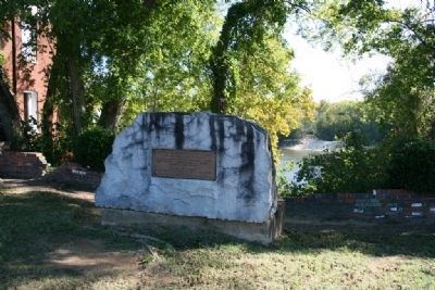
Here stood
Fort Toulouse
A defense against
the Indians
Built by
Bienville
1714
The Alabama Society
of Colonial Dames
preserves the memory
of faithful service
1912 — — Map (db m69567) HM
Near Water Streer at Commerce Street, on the right when traveling west.
Here on May 24, 1703, Alabama Indians ambushed the first French explorers from Mobile, killing three and wounding two critically. The Indians were armed and were used as pawns by British agents from Carolina in the European struggle for dominion . . . — — Map (db m67999) HM
On Greensboro Avenue (24th Avenue) south of 7th Street, on the right when traveling south.
“He was the suzerain of many territories, and of a numerous people, being equally feared by his vassals and the neighboring nations.” — — Map (db m156405) HM
Mission San Xavier del Bac was founded by Father Eusebio Kino as a Catholic mission in 1692. This Baroque architecture style building is the oldest intact European structure in Arizona. Construction began in 1783 and was completed in 1797. The . . . — — Map (db m84279) HM
On Mote Street at Hollywood Street on Mote Street.
Presented by Arkansas Col. John Washington Chapter, National Society Colonial Dames, XVII Century, honoring War Veterans, Early Pioneers, 1998 — — Map (db m61770) HM WM
On Mill Street at Santa Barbara Street, on the right when traveling south on Mill Street.
Glen Tavern Inn, built 1911.
Presented by
Aquila Chase chapter,
National Society Colonial Dames XVII Century,
12 October 2014.
The Glen Tavern Inn, built in 1911,
has been placed on the
National Register
of Historic Places
by . . . — — Map (db m175684) HM
On Second Street at Chestnut Street on Second Street.
Fort Casimir was built by the Dutch in 1651 and recaptured by them from the Swedes, 1655. Site now lies beneath the Delaware 250 feet E.N.E. from this stone which is erected by the Delaware Society of the Colonial Dames of America, 1905, to . . . — — Map (db m57130) HM
On North West Street at South Park Drive, on the right when traveling north on North West Street.
This is the original Presbyterian Meeting House built in 1740 near Tenth & Market Streets
Presented by The First Presbyterian Church of Wilmington, Delaware to The Society of Colonial Wars in the State of Delaware and The National Society of . . . — — Map (db m240742) HM
Near North Church Street (U.S. 13) at East 7th Street, on the right when traveling north.
These are the earliest dated fieldstone markers in the churchyard. Along with the carved initials, 1726 is still visible.
The initials stand for Kathrina and Brita Cock, Swedish sisters who died from typhoid fever within two days of each . . . — — Map (db m174903) HM
Near North Church Street (U.S. 13) at East 7th Street, on the right when traveling north.
This small stone is probably one of the oldest still visible in the churchyard. It is not known who M. B. was or when he or she died.
The stone is typical of the simple rough markers of the late 1600s and early 1700s. — — Map (db m174891) HM
Near North Church Street (U.S. 13) at East 7th Street, on the right when traveling north.
More than twenty Bayards are interred in this underground vault. They include four U.S. Senators: (1) James A. Bayard the Elder (1717-1815), a member of Congress, U.S. Senator, and a member of the Commission for the Treaty of Ghent in 1814; (2) . . . — — Map (db m174898) HM
Near North Church Street (U.S. 13) at East 7th Street, on the right when traveling north.
He served as pastor of Calvary Church, Rockdale PA from 1838 until 1841, at which time he was consecrated as first bishop of the Diocese of Delaware. Prior to Lee's consecration, affairs of the Episcopate had been administered by Assistant . . . — — Map (db m174913) HM
Near North Church Street (U.S. 13) at East 7th Street, on the right when traveling north.
The Brinckles are an old Delaware family. The Rev. Samuel G. Brinckle was the first Rector of Christ Church, Christiana Hundred, "preaching almost until the time of his death in 1863," Gertrude Brinckle was the longtime librarian at the . . . — — Map (db m174890) HM
Near North Church Street (U.S. 13) at East 7th Street, on the right when traveling north.
Horace Burr was a physician, an author and served in the Delaware Legislature. At Old Swedes he was Senior Warden and Vestryman. His 1899 translation of the early Swedish church records is still used today and is a valuable genealogical research . . . — — Map (db m174866) HM
Near North Church Street (U.S. 13) at East 7th Street, on the right when traveling north.
He was born in Sweden in 1658 and educated in London. On his way home from his duties in the Swedish Legation one evening in 1678, he was kidnapped and shipped to Virginia to serve five years as an indentured servant. Springer learned of the . . . — — Map (db m174895) HM
Near North Church Street (U.S. 13) at East 7th Street, on the right when traveling north.
Dr. Joseph Capelle was a surgeon in the French army serving under General Rochambeau's command. After serving throughout the Revolutionary War, he decided to make his home here in America. He became a respected practitioner, a founding member of . . . — — Map (db m174904) HM
Near Church Lane (U.S. 13) at East 7th Street, on the right when traveling north.
As noted at marker #8 "Iron Letters on the Church," wrought iron letters were hammered into the mortar on this east wall, above the altar window. Originally the lettering was "LUX-L.I. TENEBR ORIENS-EX ALTO." (Light from on high . . . — — Map (db m174906) HM
Near North Church Street (U.S. 13) at East 7th Street, on the right when traveling north.
Miss Montgomery was the daughter of Capt. Hugh Montgomery, of Revolutionary War fame. She was prominent in Wilmington society in the first half of the 19th century. A successful teacher, she was also a founding member of the Female Bible Society. . . . — — Map (db m174908) HM
Near North Church Street (U.S. 13) at East 7th Street, on the right when traveling north.
These French families fled a slave insurrection in Santo Domingo in 1791 and relocated to Wilmington. Peter Bauduy helped convince his friend Éleuthère Irénée duPont to settle here, and was an early partner of duPont's.
Some members of these . . . — — Map (db m174910) HM
Near North Church Street (U.S. 13) at East 7th Street, on the right when traveling north.
Preparations to celebrate the 300th anniversary of the consecration of Old Swedes in 1998 produced some unexpected results.
Painters removed dozens of coats of paint from the south doors in preparation for painting. They found carved . . . — — Map (db m174892) HM
Near North Church Street (U.S. 13) at East 7th Street, on the right when traveling north.
Originally it was one room with fireplace down stairs and a large bedroom above. The Hendricksons raised eight children in this house. It was enlarged later, and served as home to five generations of Hendricksons.
After many years of . . . — — Map (db m174858) HM
Near North Church Street (U.S. 13) at East 7th Street, on the right when traveling north.
Notice the numerals on the bell tower's north side and the letters on the south side.
The church was built with a hip roof at both ends. Before the consecration in 1699, Matthias de Foss, a blacksmith of the colony, forged iron letters and . . . — — Map (db m174846) HM
Near North Church Street (U.S. 13) at East 7th Street, on the right when traveling north.
Judge Ignatius Grubb (1841-1927) was of English descent. His grandfather, Henry Grubb, purchased Pennsylvania lands in 1679, three years before William Penn arrived.
In 1848, Ignatius and his family arrived at Grubbs Landing (now part of . . . — — Map (db m174899) HM
Near North Church Street (U.S. 13) at East 7th Street, on the right when traveling north.
In 1862, he transferred to Maj. Gen. Ulysses S. Grant's army, serving in staff and engineering positions.
He was promoted to staff Lieutenant Colonel and Inspector General of the Army of Tennessee. He took part in the Vicksburg campaign. In . . . — — Map (db m174845) HM
Near North Church Street (U.S. 13) at East 7th Street, on the right when traveling north.
Major Jaquett, a distinguished officer of the Delaware Militia in the American Revolution, was a participant in 32 of the war's battles and was twice wounded. He was by the side of both Colonel Haslet at Princeton and Baron De Kalb at Camden when . . . — — Map (db m174901) HM
Near North Church Street (U.S. 13) at East 7th Street, on the right when traveling north.
Over 15,000 people are buried here at Old Swedes. Many, like Miss Vining, are buried in unmarked graves. Her grave is believed to be in the southern area of the yard.
Mary was the daughter of John Vining, a Chief Justice and Speaker of the . . . — — Map (db m174909) HM
Near North Church Street (U.S. 13) at East 7th Street, on the right when traveling north.
By 1750 the heavy roof had begun to force the thick walls apart, most noticeably on the north side, and much earlier than on the south side (see mark #14). Four stone "buttresses" were built to counter this effect. Years later, these open porticos . . . — — Map (db m174914) HM
Near North Church Street (Route 13) at East 7th Street, on the right when traveling north.
Upon arrival from Sweden in 1697, Pastor Eric Björk began his quest to build a stone church to replace the decaying log structure on the south bank of the Christina River that had served the Swedish Lutheran congregation. Helga Trefaldighet . . . — — Map (db m174436) HM
Near North Church Street (U.S. 13) at East 7th Street, on the right when traveling north.
By 1763, the foundation proved inadequate and the heavy roof began o force the thick walls apart. To counter this development, two large stone buttresses were built. In 1774, the gallery was built to add 25 new pews. The stairs were placed . . . — — Map (db m174911) HM
Near North Church Street (U.S. 13) at East 7th Street, on the right when traveling north.
The Stidhams were another prominent family in the early days of the New Sweden Colony and Old Swedes.
Dr. Tymen Stidham arrived on the fourth voyage of Kalmar Nyckel. He was the the first physician in this area. Much of the success and . . . — — Map (db m174847) HM
Near North Church Street (U.S. 13) at East 7th Street, on the right when traveling north.
Their ancestor became Lutheran, fled the Netherlands to avoid persecution, and settled on the Brandywine, calling his place "Vendever's Island."
In the presence of William Penn, Dr. Cornelius and Jacob Vandever became naturalized citizens in . . . — — Map (db m174905) HM
Near North Church Street (U.S. 13) north of East 6th Street, on the right when traveling north.
Upon completion of Old Swedes, the church bell was being hung in a tree on the north side of the church. Those living across the river and to the south complained they could not hear the bell, so a wooden scaffold was erected on the south side . . . — — Map (db m217893) HM
On Tilden Street Northwest west of Beach Drive Northwest, on the right when traveling west. Reported missing.
The last of several grain mills operating on Rock Creek during an era when most American mills derived their power from small streams. Located near an Indian site. The land was conveyed to Isaac Pierce by the Revolution patriot William Deakins in . . . — — Map (db m166590) HM
Near Q Street Northwest west of 27th Street Northwest, on the right when traveling west.
In 1891, women descended from Colonial era leaders founded The National Society of The Colonial Dames of America (NSCDA) to preserve and share United States history. Over the next four decades, the NSCDA restored historic properties, raised money . . . — — Map (db m189262) HM
On 28th Street Northwest, 0.1 miles south of R Street Northwest, on the right when traveling north.
Samuel Davidson, a Scot of original character, purchased the site and built Evermay, 1792-1794, with proceeds of the sale of lands he owned which include part of the present site of the White House and Lafayette Square. Davidson was buried in a . . . — — Map (db m33792) HM
Near Q Street Northwest just west of 27th Street Northwest, on the right when traveling west.
What is seen, and sometimes not seen, on the landscape informs the process of understanding history and historic preservation. If you look up and around, what do you see?
In 1804, Dumbarton House sat on an urban farm owned by Joseph Nourse . . . — — Map (db m189266) HM
Near Q Street Northwest just west of 27th Street Northwest, on the right when traveling west.
Built in 1799, Dumbarton House stands as an example of Federal period architecture, a popular style in the United States from 1780 to 1820. Americans sought inspiration from classical Greece and Rome—in architecture as well as politics—to suggest . . . — — Map (db m226899) HM
On Q Street Northwest east of 28th Street Northwest, on the right when traveling west.
The site was part of a tract called “The Rock of Dumbarton” patented 1703 by Ninian Beall.
The house was probably started 1799 by Samuel Jackson. It was completed 1805 by Joseph Nourse, first Registrar of the Treasury. He sold the . . . — — Map (db m95765) HM
On Q Street Northwest just west of 27th Street Northwest, on the right when traveling west.
Erected by
The National Society of the Colonial Dames of America
In Grateful Commemoration of the Signing of the Constitution
by the following delegates in Philadelphia September 17, 1787
Attest: William Jackson, Secretary . . . — — Map (db m189261) HM
Near Allison Street Northwest east of 3rd Street Northwest, on the right when traveling west.
Here, the first church edifice within the future district of Columbia was erected in 1719; a "chapel of ease" of St. John's Church, Broad Creek. It was built of wood with earthen floor. The 100 acre tract named "Generosity" (Comprising the church . . . — — Map (db m70948) HM
On Alabama Avenue Southeast north of Pennsylvania Avenue Southeast, on the left when traveling north.
One of several earthworks commenced late in 1861 to guard the nation’s capital from the ridge east of the Anacostia River. The fort was named in honour of Colonel Benjamin F. Davis of the 8th New York Cavalry, killed at Beverly Ford, Virginia, June . . . — — Map (db m40690) HM
Near Alabama Avenue Southeast east of Massachusetts Avenue Northeast, on the left when traveling east.
This small work was one of the defenses begun in the fall of 1861 on the ridge east of the Anacostia River. It was named after Admiral Samuel DuPont, a commander of the South Atlantic Blockade Squadron. Eight guns and one mortar comprised its . . . — — Map (db m46425) HM
Near here Hernando DeSoto with his men landed May 30, 1539 and began his march westward to the Mississippi River. This marker commemorates the 400th anniversary of his arrival on the shores of Florida. — — Map (db m125358) HM
Francis Philip Fatio (1724-1811)
First advocate of conservation of Florida's forests and
Lina L'Engle Barnett (1859-1934)
A Colonial Dame who kept alive the doctrine of conservation in Florida and the ideals of her distinguished ancestor. . . . — — Map (db m227440) HM
On South Federal Highway (U.S. 1) at Southeast10th Avenue, on the right when traveling north on South Federal Highway.
The Boynton Woman’s Club was designed in Mediterranean Revival style by the famous Palm Beach architect Addison C. Mizner. The Woman’s Club is significant for both its architectural merit and contributions to the cultural development of Boynton . . . — — Map (db m96653) HM
Near South Lake Trail, 0.1 miles west of Cocoanut Row, on the left when traveling south.
Constructed in 1886 by R.R. McCormick, a Denver railroad developer, Sea Gull cottage was purchased by Henry Flagler in 1893 and became Flagler’s first winter residence in Palm Beach. The Royal Poinciana, Flagler’s first resort hotel in Palm Beach, . . . — — Map (db m114828) HM
On South Tamarind Avenue, 0.1 miles north of Evernia Street, on the left when traveling north.
The Seaboard Air Line Railway Station has played an important role in the history of West Palm Beach and Palm Beach County. It is a unique example of early 20th century railroad architecture in the Mediterranean Revival style. The Station opened . . . — — Map (db m96762) HM
On Orange Street at St. George Street, on the left when traveling east on Orange Street.
This Gate opened in 1739, provided the only
access through the defense line
on the north side of Spanish St. Augustine.
Royal Engineer Manuel de Hita
built these coquina pillars in 1808.
This tablet was originally erected in . . . — — Map (db m127892) HM
On Montgomery Street near W. Bryan Street, on the left when traveling north.
Born in Pocotaligo, SC, Jonathan Bryan accompanied James Oglethorpe on his initial visit to Yamacraw Bluff in 1733. One of Georgia’s largest landholders, Bryan was a supporter of evangelist George Whitefield and encouraged religious services for his . . . — — Map (db m41816) HM
On West Bay Street near Whitaker Street, on the left when traveling east.
On this spot one hundred and seventy three years ago James Oglethorpe the founder of the colony pitched his tent and here rested at the close of the day from which Georgia was settled. — — Map (db m16064) HM
On Bay Street at Bull Street, on the right when traveling east on Bay Street.
1736-1740
On this site stood the house
occupied by James Edward Oglethorpe
when in Savannah.
His home he made in Frederica
the better to protect
the young colony — — Map (db m6499) HM
On East Broughton Street, on the right when traveling east.
On this site stood the Printing Office of James Johnson Official Printer of Laws and Paper Currency of the province. He was the founder of "The Georgia Gazette" the only newspaper in the colony. The first issue appearing April 7, 1763 — — Map (db m6488) HM
On Abercorn Street south of East Macon Street, on the left when traveling south.
Mary Musgrove was the daughter of an English trader and a Creek Indian mother. In 1717 she and her husband, John, established Cowpens trading post near the Savannah River which became a center of 18th century English-Indian trade for deer hides. . . . — — Map (db m132897) HM
On 2nd Avenue Southeast at 1st Street Southeast (Business U.S. 319), on the right when traveling west on 2nd Avenue Southeast.
This sundial was given to the Moultrie Chapter of the Colonial Dames of America in 1993 to commemorate the 100th year of the founding of The Colonial Dames of America in Georgia. The sundial is the oldest known device that is used to measure time. . . . — — Map (db m197799) HM
On Egmont Street just north of George Street, on the left when traveling south.
Wright Square, one of the two largest of the original 14 squares of Brunswick, was named after Georgia’s last Colonial Governor, Sir James Wright (1716-1785). Well-respected and fair, Wright held his office from October 13, 1760 until the end of . . . — — Map (db m212684) HM
We are resolved not to suffer
defeat - we will rather die like
Leonidas and his Spartans - if we
can but protect Georgia and
Carolina and the rest of the Americans
from desolation Oglethorpe
Erected on the battlefield . . . — — Map (db m63868) HM
This remnant is all
that time has spared of the
citadel of the town of Frederica
built by
General Oglethorpe
A.D. 1736
As an outpost against
The Spanish in Florida — — Map (db m18919) HM
On Ocean Highway (U.S. 17) at Adams Street (Georgia Route 99), on the left when traveling south on Ocean Highway.
To the
Highlanders of Scotland
who founded New Inverness in 1736 AD
Their valor defended the struggling colony
from - the - Spanish - invasion
Their ideals traditions and culture . . . — — Map (db m10820) HM
On Linwood Boulevard at 8th Street, on the left when traveling east on Linwood Boulevard.
A part of the 1828 plan of Columbus, Linwood contains graves of pioneer citizens and their descendents, as well as the tombs of some 200 Confederate soldiers. Among those buried here are Anna Caroline Benning (1853-1935), who formed the . . . — — Map (db m46947) HM
On West Harris Street just east of North Madison Avenue, on the right when traveling east.
Harris, author of the Uncle Remus stories, his mother and grand-mother moved in 1853 to a small two room house here in the back yard of the Andrew Reid Mansion from Barnes Tavern. The women did sewing for the large Reid family. Joel's mother, a . . . — — Map (db m186598) HM
To commemorate the great congress of
five Indian Nations held here at Fort
Augusta in 1763. When seven hundred
Indians came to meet the Governors of
Georgia, Virginia, North and South Carolina. — — Map (db m9899) HM
This stone marks the site
of the
Colonial Fort Augusta,
built by order of General Oglethorpe
and the trustees
in 1736;
and known,
during the Revolution as
Fort Cornwallis.
St. Paul Church was built
in 1750,
under the curtain of . . . — — Map (db m9803) HM
On North Michigan Avenue, on the left when traveling north.
In Honor of Louis Jolliet & Père Jacques Marquette
The First White Men to Pass Through the Chicago River
September 1673
This Tablet is placed by the Illinois Society of the Colonial Dames of America
Under the auspices of the Chicago . . . — — Map (db m99733) HM
In honor of Rene Robert Cavalier Sieur de La Salle & Henry de Tonti who passed through this river on their way to the Mississippi December 1681
This Tablet is placed by the Illinois Society of Colonial Dames of America under the auspices of the . . . — — Map (db m47683) HM
On North Michigan Road (U.S. 421) north of Cold Spring Road.
Operated by Augusta Gravel Road Co., circa 1866-1892. First major state road, built in the 1830's, from the Ohio River to Lake Michigan. — — Map (db m563) HM
On Old State Road 37 North, 0.1 miles south of Central Avenue, on the right when traveling north.
A Trail from Whitewater River at Laurel terminated here at the Bluffs of White River. Cut in 1818 by Jacob Whetzel, it was the first east-west road into central Indiana. — — Map (db m66830) HM
On State Road 933 at Darden Rd, on the right when traveling north on State Road 933.
Site of La Salle's camp, 1679, on portage between St. Joseph and Kankakee rivers. La Salle was the first white man to enter Indiana, passing here again in 1681. — — Map (db m61797) HM
On McPherson Avenue at Riverside Avenue, on the right when traveling east on McPherson Avenue.
This tablet marks the site
of the first capital
of the
Territory of Kansas
Used by
Governor Andrew H. Reeder
October 7, to November 21, 1854 — — Map (db m66671) HM
On Lancaster Road (Kentucky Route 39) at Gilbert Creek Road (Kentucky Route 642), on the right when traveling south on Lancaster Road. Reported missing.
In search of religious freedom, the Reverend Lewis Craig led his entire congregation of 200 Baptists and 400 other settlers from Spotsylvania County Virginia and established them here on Gilbert's Creek.
This expedition, guided through the . . . — — Map (db m173233) HM
On Kentucky Route 8, 0.7 miles west of the Bridge to Ohio (Kentucky Route 852), on the right when traveling west.
First village in Kentucky built
by Shawnee Indians and French
traders. Visited in January 1751 by
Christopher Gist, George Croghan,
Andrew Montour, Robert Kallendar
and a servant. Located on site of
an earlier Fort Ancient settlement,
it . . . — — Map (db m146890) HM
On W Jefferson Street at S 5th Street, on the right when traveling west on W Jefferson Street.
Soldier, Patriot. Founder Of Louisville. Founder Of Kentucky. Conqueror of our first great west from the Alleghany Mountains to the Mississippi River. A son of Virginia. A gallant gentleman and a great American. — — Map (db m104489) HM
Near W Main Street at N 7th Street, on the right when traveling west.
The Stockade
On Corn Island, 1778.
A group of pioneers,
under the military protection
of General George Rogers Clark,
made the original settlement
of the town of Louisville
in May, 1778 on Corn Island,
then about one hundred fifty . . . — — Map (db m104417) HM
On McCready Avenue at Trinity Road, on the right when traveling south on McCready Avenue.
The rock spring on Beal's Branch 800 feet south marks Spring Fort. One of the pioneer "Beargrass settlements" contemporary with the founding of Louisville. When its commander, Richard Steele, was wounded in an Indian attack, his wife, at Floyd's . . . — — Map (db m161994) HM
On Main Street (U.S. 60) at 5th Street, on the left when traveling east on Main Street.
"Painted Stone" 2½ miles north on Eminence Road, thence, ½ mile west to site on Clear Creek. For nearly 2 years, only large station on the Wilderness Road, between Harrodstown and the Falls of the Ohio River. Ground plan found among papers . . . — — Map (db m136884) HM
Near Shreveport Highway (U.S. 71) 0.3 miles north of Executive Court, on the right when traveling north.
This Stone Was A Part Of The 1st LA. Seminary Built A.D. 1859 And marks the original site Destroyed by fire in 1869 Placed by The Colonial Dames Of Alexandria June 1926 — — Map (db m110805) HM
On West Street (Maryland Route 450) at Calvert Street, on the right when traveling east on West Street.
All roads leading to this provincial capital, marked AA to guide the traveler, entered the city here beside the city gate house. A wooden fence, enclosing the city, kept out wandering cattle and "men of ill fame." — — Map (db m6190) HM
On Crain Highway (U.S. 301) at Port Tobacco Road (Maryland Route 6), on the right when traveling south on Crain Highway.
11.8 miles West near Ironsides, MD. Oldest church in Charles County. Served by thirty rectors through 257 years. Present building erected 1732. Visited by George Washington 1771. Restored by Governor Smallwood 1791. — — Map (db m36840) HM
Near Susanna Lane, 0.2 miles east of Jones Mill Road, on the right when traveling north.
This Spring is on the site of Clean Drinking, a land grant surveyed for Col. John Courts in 1699. Descendants of Courts, the Jones family, lived at nearby Clean Drinking Manor for many years.
Placed by the National Society of the Colonial Dames . . . — — Map (db m61517) HM
Near Trinity Church Road near Point Lookout Road (Maryland Route 5).
Here lyeth the body of Lionel Copley of Wadworth, County York, England, born 1648, died Sept. 27, 1693. And of Anne Boteler, his wife, of Watton, Woodhull, County Herts, England, died March 5, 1692.
He was sometime Lieutenant Governour of . . . — — Map (db m1005) HM
Discovered by Henry R. Schoolcraft from the summit of this hill July 13, 1832 This tablet is placed by the Society of Colonial Dames of America in the State of Minnesota 1924 — — Map (db m155676) HM
On U.S. 61 at Kingston Road, on the right when traveling north on U.S. 61.
8.8 Miles to KINGSTON First Protestant Settlement In Mississippi Territory 1773.Dedicated 1955 by The National Society Of The Colonial Dames of America In The State Of Mississippi. — — Map (db m120264) HM
Near North West Street, on the left when traveling north.
In Memory
of
Seven Early Governors
of the State of Mississippi
Buried in
Greenwood Cemetery
George Poindexter
January 5, 1820 to January 7, 1822
Abraham Marshall Scott
January 9, 1832 to June 12, 1833
Charles Lynch . . . — — Map (db m131002) HM
On North Washington Street (Business U.S. 61) 1.3 miles 1st East Street when traveling north.
Fort Nogales, which was the first settlement at Vicksburg, was established by the Spaniards on this spot in 1791. In 1798, it passed from the possession of Spain to the United States and was re-named Fort McHenry. It was used as a Confederate fort . . . — — Map (db m103759) HM
This boulder stands near the site of the Great Indian Mound, leveled about 1870, which gave the city of St. Louis the name "Mound City" — — Map (db m139362) HM
On Kings Highway at Chew’s Landing Road, on the left when traveling south on Kings Highway.
King’s Road → Laid out in 1681 over a portion of the trail of the Lenni Lenape Indians running from Perth Amboy to Salem. --------------- Chew’s Landing Road ← Used by the early New Jersey colonists. --------------- This stone . . . — — Map (db m120868) HM
On Broad Street at Branford Place, on the right when traveling north on Broad Street.
This tablet is placed upon this church the oldest of all our local institutions, in memory of the first settlers who founded “Ye town upon ye Pesayak” 1666 Erected by the Newark members of the New Jersey Society of Colonial Dames of . . . — — Map (db m40830) HM
On River Road at Washington Crossing Pe Rd, on the left when traveling north on River Road.
In commemoration of the two hundredth birthday of George Washington These eagles and this tablet were placed here by the New Jersey Society of the Colonial Dames of America — — Map (db m7275) HM
On Broad Street (Route 623) at Caldwell Place, on the right when traveling south on Broad Street.
This tablet marks the first site of Princeton University incorporated Oct 22nd 1746 --------------- Erected by the Elizabeth Members of the New Jersey Society of Colonial Dames of America – Oct 22nd 1897 — — Map (db m40708) HM
Near Sandy Redoubt, on the right when traveling east.
of Pittsfield, Mass. killed October 19th, 1780 at Stone Arabia, N.Y. on his thirty-fifth birthday. Was with Ethan Allen, May 10th, 1775. Made a gallant attempt to retake the fort September 17th to 22nd, 1777 but failed owing to the sturdy defence . . . — — Map (db m9484) HM
157 entries matched your criteria. The first 100 are listed above. The final 57 ⊳