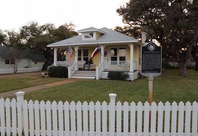
Built in 1903 in Old Rockport, this Cottage and Craftsman Style House is an early frame Bungalow surrounded by giant oak trees. In 1920, W.H. Smith, grandson of early Refugio pioneers, bought this house where he lived with his second wife, their . . . — — Map (db m211222) HM
Simon Sorenson, a native of Denmark, bought Brunner’s Mercantile at this site in 1886. The building was originally two stories, rebuilt after an 1895 fire. The Sorensons received weather reports by telegraph, posted updates in the display windows . . . — — Map (db m53592) HM
The Rt. Rev. Alexander Gregg, Bishop of the Diocese of Texas, officiated at the dedication of St. Peter’s Episcopal Church in Rockport on November 30, 1871. Led by lay ministers for much of its early history, St. Peter’s first was located at the . . . — — Map (db m53581) HM
Rockport’s original Big Blue Crab started out on the Del Mar Grill on Austin Street. In 1957, the Grill was run by Dorothy and Sal Silverman, and the specialty was Dorothy’s famous crab cakes. The Big Crab was 18 feet wide and 22 feet deep and was . . . — — Map (db m63660) HM
Tourism has been a major part of the Rockport economy for generations, but in the 1920s and 1930s with the rise of the automobile, more visitors began to travel to the area. The Cedars, built in 1928 by Dr. Joe and Mabel Bryant, became a popular . . . — — Map (db m60573) HM
This property was the site of the famous Rockport Cottages purchased in 1934 by Connie and Jack Hagar from Corsicana, Texas. Jack managed the cottages while Connie (1886–1973) pursued her passion for nature. Birds were Connie’s major interest, . . . — — Map (db m63659) HM
In early Rockport, many prominent families lived on what was called the Old Beach Road, now Water Street. Paved with white crushed shell, the road was lined with huisache, anacua, wild persimmon, prickly ash trees, dewberry vines, and stately homes. . . . — — Map (db m53767) HM
For more than 60 years, Rockport’s skyline was dominated by an imposing, three-story Moorish-inspired courthouse. It was the first major building designed by J. Riely Gordon, who would become one of Texas’ most famous architects. Born in Virginia in . . . — — Map (db m53768) HM
After the Civil War, Rockport became an important cattle ranching and shipping center. In 1866, James Doughty, T.H. Mathis, and John M. Mathis constructed cattle pens, with a long wharf that extended out into Aransas Bay from “Rocky . . . — — Map (db m53771) HM
The earliest newspaper in this area was “The Vaquero”, published by Charles F. Bailey and Geraldo A. Beeman in St. Mary’s in 1868. In 1869 Bailey moved to Rockport and founded “The Transcript”, which continued in operation . . . — — Map (db m53588) HM
During its early years Rockport relied on Gulf shipping for goods and services. After the arrival of the San Antonio and Aransas Pass Railroad in 1888, however, the town’s economic focus changed to include rail shipping and a burgeoning tourism . . . — — Map (db m53589) HM
In March 1948, Mrs. Fred B. Hunt issued a call to organize the Woman’s Civic Club. One of the club’s major early activities was financing a permanent building for the organization. Later that year the recreation building for Humble Oil Company . . . — — Map (db m53586) HM
Tobias “T.R” Wood purchased lots at a sheriff’s auction in 1910 and built this Queen Anne style house. T.R. worked on his father’s cattle ranch located on San Jose Island. When T.R. moved to Victoria to practice law, his brother, Will W. Wood and . . . — — Map (db m212054) HM
Jesse James, celebrated 1860s-82 Missouri outlaw, used to visit in Archer City in house built by Stone Land and Cattle Company for its manager, Allen H. Parmer (1848-1927), his Confederate comrade of the Civil War and husband of his sister Susan . . . — — Map (db m187140) HM
A part of the Peters Grant, 1841
Created January 22, 1858
Organized July 27, 1880
Named in honor of
Dr. Branch Tanner Archer
1790-1856
Texas Commissioner to the
United States, 1835, Member of
Congress, Secretary of War
of . . . — — Map (db m187144) HM
The civilized world first heard of copper in this area from Texas Rangers after an 1860 campaign against Comanches on the Pease River, about 100 miles to the northwest. The Ranger Captain, Lawrence S. ("Sul") Ross, later to serve Texas as Governor, . . . — — Map (db m17912) HM
M. P. Andrews No. 1, drilled in 1911, reached oil sands at 920 feet. Well first flowed oil, March, 1912, at rate of 10 barrels a day.
Production in this shallow sand development area fell off when oil prices dropped, but rose after other . . . — — Map (db m187139) HM
By 1909 Archer County had outgrown its original jail, a 16-foot square frame building. Construction on this larger facility was completed in Sept. 1910. The sandstone structure was designed with living quarters for the sheriff and his family on the . . . — — Map (db m187143) HM
Strategically established during Civil War on defense line Red River to Rio Grande where Gainesville-Fort Belknap Road crossed west fork Trinity River about 10 miles south, 4 miles east of Archer City. Texas Frontier Regiment patrolled area . . . — — Map (db m187138) HM
Landowner Charles E. Graham (1872-1937) in 1908 granted the Wichita Falls and Southern Railroad a route across his property and platted a town at this site. Anarene was named for his wife Annie Lawrence Graham, daughter of pioneer cattleman J. . . . — — Map (db m187146) HM
In the mid-1700s, Indians of this region met at a trading ground near this site with Frenchmen who brought them manufactured goods, sometimes including guns and ammunition - products denied them by the Spanish who held sovereignty, but could not . . . — — Map (db m187195) HM
This stone is erected
to the memory of
Sheriff E. Harrison Ikard
by the Commissioner's Court
American Legion
and loyal friends
in recognition of
a man who holding sacred
a public trust
answered duties call
fearless unto . . . — — Map (db m187141) HM
Area Confederate veterans officially formed the Stonewall Jackson Camp #249, United Confederate Veterans, in 1897. The group purchased 106 acres located south of Holliday, along Holliday Creek, as a permanent location for meetings and reunions. . . . — — Map (db m187233) HM
Born Hollidaysburg, Pennsylvania; came to Texas about 1835, joined Texian Army, and was one of 24 survivors of the Goliad Massacre, March 27, 1836. Joined Texian-Santa Fe Expedition, and en route to New Mexico, Aug. 4, 1841, carved his name on a . . . — — Map (db m187196) HM
The result of a 1923 oil boom, development of a town at this site included some twenty-two businesses, including a food stand operated by a man with the nickname "Dad", which provided a name for the settlement. Located at this crossroads were a . . . — — Map (db m187230) HM
In 1901, after failing to locate suitable land in Oklahoma, the American Tribune New Colony Company of Indianapolis acquired over 59,000 acres in this area for an immigration project. A post office was established in March 1902, and by grand . . . — — Map (db m187227) HM
The town of Holliday was officially organized near Holliday Creek in 1890, when the city was platted. The Wichita Valley Railway was built through the area, and a post office was established. In that same year, Maggie Elizabeth Holt and H.W. . . . — — Map (db m128750) HM
On August 3, 1859 US Indian Agent Robt. S. Neighbors passed this way and camped near here with 1,051 Indians, carts, wagons, cattle, horses and four companies of US Cavalry and Infantry en route to Indian Territory Oklahoma to relocate the tribes . . . — — Map (db m157928) HM
In 1910, thirty years after the Texas Legislature created Archer County, the Gulf, Texas & Western Railroad began extending its track from Jacksboro to Seymour. That year the Trinity Townsite Company laid out a new town along the tracks on land . . . — — Map (db m187149) HM
After living 1854-58 on the reservation set aside by State of Texas near Camp Cooper (30 mi. SW), the Comanche Indians with their goods were removed to Oklahoma. Near this spot on a head branch of Kickapoo Creek (so named, 1830) the . . . — — Map (db m187150) HM
The Trinity, a major Texas river rises 250 yards west of this 1250-foot mound. South of this site water drains to the Brazos, and north and west to the Red. This high point has been important in Texas history. It guided Capt. Diego Parilla to battle . . . — — Map (db m187147) HM
German native John H. Meurer (b. 1850) settled his family in this area about 1900 when he became a land agent for H. J. Scott of the Clark and Plumb Company. In selling over 60,000 acres of land, Meurer helped to establish the towns of Windthorst . . . — — Map (db m157893) HM
Established as the "Argus," Jan. 1, 1890, in the new railroad town of Claude. Later it merged with "Goodnight News" to become "Claude News." First publisher, W. S. Decker, sold paper to B. F. Hines, who sold to J. H. Hamner, in 1892. His daughter . . . — — Map (db m100448) HM
Created 1876. Name honors several Texas pioneers named Armstrong. Ranching became the chief industry when huge JA Ranch was established here in 1876.
Farming was introduced after the railroad came through, 1887. County was organized in 1890. . . . — — Map (db m96833) HM
Erected in 1953, this building is constructed of stone used to build the first masonry jail in Armstrong County, 1894. Stone for the structure (which replaced a primitive, frame "calaboose") was quarried 14 miles south at Dripping Springs in Palo . . . — — Map (db m96830) HM
One of the oldest Scout troops west of the Mississippi River, this group was organized in May 1912 by pioneer physician Dr. W. A. Warner (1864-1934). The first troop of about 30 boys met in a room above Dr. Warner's drugstore and office. Because of . . . — — Map (db m96837) HM
Winner, Congressional Medal of Honor for heroism during the Allied Forces’ invasion of Peleliu in the western Pacific in World War II. On July 21, 1945, he was decorated posthumously by presentation of his medal to his mother, Armstrong County . . . — — Map (db m62834) HM
Claude native Charles H. Roan volunteered for World War II service in the U.S. Marine Corps in December 1942. On active duty in the Pacific, he was killed in battle on Peleliu Island when he threw himself on a Japanese grenade, thereby saving the . . . — — Map (db m96839) HM
Dan Cavanagh settled here in 1885 and bought this land in 1888. In 1890 he gave a grave site for railroad worker Neal DeBerry. Settler C.C. Bates was buried in 1890, and early burials from the Fort Worth & Denver Railroad right-of-way were later . . . — — Map (db m100495) HM
Locomotive engineer piloting the first Fort Worth & Denver passenger train to reach here, 1887. Town was given his name. Recorded - 1971 — — Map (db m151614) HM
Two of the most admired and beloved pioneer citizens of Armstrong County, Dr. Warner (1864-1934) was a country physician and his wife Phebe (Kerrick) (1866-1935) was an ardent humanitarian.
Natives of Illinois, they were married in Claude in . . . — — Map (db m96834) HM
William Miles Dye was born in Kentucky in 1864 and moved to Texas with his parents in 1870. He settled in this area in 1891, one year after the organization of Armstrong County. By hauling rock from Palo Duro Canyon, Dye helped in the construction . . . — — Map (db m100511) HM
Inheriting peacekeeping duty from 1874-90 ranchers, the early sheriffs of Armstrong County (organized 1890) won great public regard. With their families, these men lived in jail quarters and fed the prisoners. There was no salary; fees were earned . . . — — Map (db m96831) HM
Organized on May 18, 1890, by 19 charter members, with the Rev. B. E. Hure as moderator. The Rev. Count C. Storts was the first resident pastor. The congregation worshipped in the Presbyterian church building until 1899, when a frame sanctuary was . . . — — Map (db m100492) HM
Named for William H. Hamblen (1878 - 1952), who in 1890s pioneered a crude road (about 6 mi. N) into Palo Duro Canyon along old Indian trails. This cut 120 miles off settlers' trips to the courthouse in Claude, but was steep and dangerous. Hamblen . . . — — Map (db m23982) HM
Born in Chester County, Tenn., son of Joseph Cyrus and Emily Kirk Carroll. Married Claudia Haltom, 1900. Graduated 1901 from University of Tennessee. Moved to Claude, 1914. In career of 54 years, delivered over 2500 babies.
A staunch Democrat; a . . . — — Map (db m100494) HM
Led by Francisco Vazquez de Coronado, this trail-blazing expedition set out from Mexico City in 1541 in search of Cibola, fabled 7 Cities of Gold. Finding only Indian pueblos, Coronado changed his course for Quivira, a supposedly wealthy Indian . . . — — Map (db m96835) HM
Although most Indians had left the Texas Panhandle by the 1880s, fear of Indian attacks was still prevalent among settlers who arrived in the next decade. On Jan. 29, 1891, rumors of approaching Indians spread throughout the entire region. For three . . . — — Map (db m96838) HM
Pioneered at this site, in dugout to the west. S.P. Hamblen (1846-1930) and wife Virginia (1861-1950) settled in Lakeview area (9 mi. S of Claude) in 1889. Hamblen helped establish Lakeview School, 1890. He engaged in farming and stockraising, and . . . — — Map (db m23990) HM
Founded when Fort Worth & Denver Railroad built into area (1887). Claude Ayers, engineer on first passenger train through here, suggested town be named for him — and citizens agreed.
Jerry Cavanaugh, first resident, gave land for town. . . . — — Map (db m96836) HM
Texas Ranger, Indian fighter. At age 19, on way to California gold fields, saw ranching possibilities. Settled and started ranch in Palo Pinto county, 230 miles southeast of here.
In Civil War, scout, guide and hunter for frontier regiment, . . . — — Map (db m49323) HM
The legacy of Quanah Parker and
Charles Goodnight is that former
enemies can become good friends
Arrow Sculptor: Charles A. Smith
— — Map (db m151421) HM
First ranch in the Texas panhandle
Established in 1876 by
Charles Goodnight
1836- 1929
Noted scout, Indian fighter, trail blazer
and rancher
The Burbank of the range — — Map (db m49328) HM
Planned by R. E. Montgomery, son-in-law of Fort Worth & Denver City Railway Builder-President Gen. G. M. Dodge. Named for family friend. Promoted 1887, Washburn for a time was F.W. & D.C. Line's terminus. It had first newspaper on Plains— . . . — — Map (db m96646) HM
1874 the Comanche, Kiowa & Cheyenne fought Col Mackenzie & 4th Cavalry Palo Duro Canyon 6 mi NW of Wayside
Arrow sculptor: Charles A. Smith — — Map (db m154185) HM
In the opening battle of the U.S. Army's 1874 Indian campaign against the Southern Plains Indian Tribes, a force of 744 soldiers under Col. Nerlson A. Miles fought a 5-hour running battle with the Cheyenne, Comanche and Kiowa 10 mi. E. of this . . . — — Map (db m100514) HM
Early settlers Dario and Manuelita Douglas Tober acquired land here in 1877 and later set aside this site for a family cemetery. The oldest marked grave, that of teenager Nieves Douglas Tober, dates to 1903. The Tober family deeded the original . . . — — Map (db m56664) HM
Kings Highway Camino Real Old San Antonio Road
Marked by The Daughters of The American Revolution and The State of Texas A.D. 1918 — — Map (db m223167) HM
Kings Highway Camino Real Old San Antonio Road
Marked by The Daughters of The American Revolution and The State of Texas A.D. 1918 — — Map (db m223168) HM
Near the Old San Patricio Trail, leading from San Antonio to McMullen and McGloin colony, in area of Gulf of Mexico. In this vicinity were stage stops at Belle Branch, Rock Spring, Rountree's, and Tordilla. Land was part of the Butler, Hickok, Tom . . . — — Map (db m56591) HM
As early as 1722 El Camino Real (The King's Highway) from the Rio Grande to San Antonio was well established in this area. The Spanish word "Atascosa," denoting boggy ground that hindered travel, gave region its name. The county was created in . . . — — Map (db m201987) HM
Atascosa County was created from Bexar County in 1856. The first county seat was at Navatasco, on land donated by Jose Antonio Navarro, and the county's first courthouse was a log cabin. The county seat was moved to Pleasanton in 1858, and a frame . . . — — Map (db m56584) HM
This log cabin is a replica of first courthouse built 1856 near Amphion (Navatasco) 9 miles to the northwest, on site given by Jose Antonio Navarro out of his 1828 grant from Coahuila and Texas. A signer of the Texas Declaration of Independence, he . . . — — Map (db m56636) HM
In October 1909, just one month after the founding of Jourdanton, seven residents gathered to organize a Baptist church under the direction of the Rev. W.G. Gilstrap. Members first met in the community schoolhouse for worship services and were led . . . — — Map (db m180811) HM
Jourdan Campbell (1867-1938) and his family moved to Atascosa County by 1870; his father John Campbell founded Campbellton. Jourdan married Alice Louise Marr in 1897 and the couple had eight children. Jourdan became County Commissioner in the 1890s, . . . — — Map (db m130161) HM
In 1909, Jourdan Campbell (1867-1938) and Theodore H. Zanderson (1854-1927) established the Jourdanton community, named for Campbell, on the eastern edge of their Toby Ranch property. Jourdan Campbell was born in Atascosa County, and was a merchant . . . — — Map (db m56595) HM
T.H. Zanderson and city namesake Jourdan Campbell bought the 40,000-acre Toby Ranch in 1907 and laid out the town of Jourdanton. The original plat included two blocks designated for use as a cemetery. The Artesian Belt Railroad built through the . . . — — Map (db m56665) HM
From a tiny school to an official, recognized single campus concept, the Jourdanton Independent School District has remained dedicated to education and community. In the early 20th century, county schools such as the Hilburn School northwest of . . . — — Map (db m180815) HM
The Methodist church in Jourdanton formally organized in 1909, the same year that the City of Jourdanton was founded. The church began as the Jourdanton Methodist Episcopal Church, South, and was a member of the Uvalde District in the West Texas . . . — — Map (db m56666) HM
Kings Highway Camino Real Old San Antonio Road
Marked by The Daughters of The American Revolution and The State of Texas A.D. 1918 — — Map (db m223165) HM
Kings Highway Camino Real Old San Antonio Road
Marked by The Daughters of The American Revolution and The State of Texas A.D. 1918 — — Map (db m223166) HM
By the early 20th century the ranching industry that spurred the growth of Atascosa County had begun to wane, with many large ranches split into smaller ranches, farms and town lots. George M. Martin realized the importance of a company to research . . . — — Map (db m56667) HM
As transportation increased through Atascosa County with the creation of major highways, the number of vehicular accidents and fatalities increased. In 1952, thirteen fatalities and many serious injuries were reported as the "bloodiest year" in . . . — — Map (db m130163) HM
County officials rented a small Jourdanton house for a jail in 1911 after the county seat was moved here from Pleasanton in 1910. A proposal to build a new jail with cells from the old Pleasanton structure was rejected and this reinforced-concrete, . . . — — Map (db m56585) HM
R. R. "Railroad" Smith (1880-1944) was born in Gonzales County to Alexander Frohock and Mary McGill (Mathews) Smith. Around 1907, Smith moved to Atascosa County where he opened up a law practice and entered into the newspaper business with a cousin. . . . — — Map (db m56668) HM
St. John Evangelical Lutheran Church has served this area of Atascosa County since 1918. Around that time, the now-dispersed farming settlement of Dobrowolski was growing, and the mostly Lutheran population needed a place of worship. At first, the . . . — — Map (db m56670) HM
Following the establishment of Jourdanton in 1909, many Catholic families of Hispanic, Irish, Polish, and German descent expressed interest in building a church. Bishop J.W. Shaw traveled from San Antonio to assist in preparing a new church . . . — — Map (db m130160) HM
Texas' bloodiest military engagement -- the Battle of Medina -- may have taken place in this general vicinity in 1813. The early 19th century was a time of political upheaval, and in 1812, while the U.S. was at war with England, Spain faced . . . — — Map (db m56597) HM
Brite Cemetery has served citizens of Atascosa County since the 1850s. It was formally set aside when Thomas Ransdele Brite passed away in 1859, though the earliest marked burial is that of his infant son, Dan (d. 1854). Thomas Brite was born in . . . — — Map (db m56588) HM
Kings Highway Camino Real Old San Antonio Road
Marked by The Daughters of The American Revolution and The State of Texas A.D. 1918 — — Map (db m223159) HM
Kings Highway Camino Real Old San Antonio Road
Marked by The Daughters of The American Revolution and The State of Texas A.D. 1918 — — Map (db m223163) HM
The first burial in this graveyard, that of fourteen-year-old John Uzell, took place in 1857. The land at that time belonged to Isaac H. Cavender, Sr., who was related to Uzell. Cavender allowed other burials on his property and soon the graveyard . . . — — Map (db m56610) HM
Organized by eleven Master Masons in Benton City in 1872 and chartered June 9, 1873, by Grand Lodge of Texas. First hall, erected of stone in 1876, provided space for public school. The lodge, which has furnished social and cultural leadership to . . . — — Map (db m56586) HM
First public cemetery in this community, which was famous in early days for its outstanding school, aggressive businesses, and newspaper, the Benton City "Era." Site was given by James M. Jones, farmer-livestock raiser and leading citizen, whose . . . — — Map (db m56587) HM
Dr. J.V.E. Covey and 16 charter members organized this church in April 1893 and held their first meeting under a stand of oak trees. A small frame building was later built, becoming their first permanent church building. Early baptisms were . . . — — Map (db m56593) HM
According to oral history, the Lytle Methodist Episcopal Church, South, was founded in 1889. W.C. Newton, a local farmer and preacher, became known as "The Father of the Lytle Methodist Church" due to his efforts to establish a permanent place of . . . — — Map (db m56596) HM
Chartered March 27, 1871, on petition of Master Masons of Pleasanton Lodge No. 283, A.F. and A.M., and the surrounding area. Met in upper floor of the Isaac Cooper home until 1891; over Cooper Brothers store until Masonic Hall was built in 1961. . . . — — Map (db m56589) HM
Established on land purchased in 1901, the town of Coughran was named for founder and early settler W. A. "Abe" Coughran. He persuaded the San Antonio, Uvalde and Gulf Raildroad to build tracks through his property. The town was platted in 1913; by . . . — — Map (db m56590) HM
On December 16, 1866, seven charter members met together to organize the First Baptist Church of Pleasanton. They met for worship in a variety of places, including the county courthouse in 1867, a schoolhouse south of town in 1870, and the Rock . . . — — Map (db m56594) HM
Constructed of locally quarried red sandstone, the Old Rock Schoolhouse was built in 1874 with funds pledged by citizens of Pleasanton. Once completed, the building was deeded to the county for free public school purposes. In addition to its . . . — — Map (db m56605) HM
Named for early Texas settler John Pleasants, by John Bowen (d.1867), San Antonio's first Anglo-American postmaster. Bowen, assisted financially by associate Henry L. Radaz, in Sept. 1858 founded this town at the juncture of Atascosa River and . . . — — Map (db m56599) HM
Begun in 1865 as a family burial ground, the Pleasanton City Cemetery is a reflection of the history of the community from its earliest days. The first burial was that of three-year-old Gustave B. Doak, whose parents, Jonathan and Mary Elizabeth . . . — — Map (db m56600) HM
This congregation was organized in 1857, one year before the city of Pleasanton was founded. The church was established largely through the efforts of early Methodist circuit preachers such as John Wesley DeVilbliss and Augustus C. Fairman, who . . . — — Map (db m56601) HM
Pleasanton School District began educating African American children in 1913 with the creation of the Abraham Lincoln School. By 1955, students from the Lincoln School and white students were participating in football workouts together and . . . — — Map (db m56602) HM
Between 1850 and 1860, Manuel, Enrique, and Francisco Esparza brought their families to settle in what is now Atascosa County. The brothers, along with their sister and mother, were within the walls of the Alamo when it fell to the Mexicans in March . . . — — Map (db m56608) HM
By 1855, settlers primarily from Alabama, Arkansas, Georgia, Mississippi, Missouri and Tennessee, as well as some of Spanish origin, were making their homes in this area and calling themselves Lucas Community because of their proximity to Lucas . . . — — Map (db m56611) HM
Amphion traces its beginning to the establishment of Atascosa County's first courthouse which is believed to have been constructed near this site at the county seat of Navatasco in 1857. Amphion, thought to have been named after a figure in Greek . . . — — Map (db m56582) HM
The family of William and Mary Allen Stiggins emigrated here from Prince Edward Island, Canada, in 1882. Included in the group were their daughter Mary Jane (1855-1935), who had studied medicine, and her fiancé Thomas Whittet (1838-1913), a former . . . — — Map (db m56633) HM
The town of Poteet traces its history to the 1880s, when Francis Marion Poteet (1833-1907) established a mercantile store northeast of this area. A blacksmith and farmer as well as a merchant, Poteet began providing mail service to his customers. . . . — — Map (db m56603) HM
14524 entries matched your criteria. Entries 201 through 300 are listed above. ⊲ Previous 100 — Next 100 ⊳