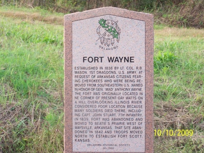
Established in 1838 by Lt. Col. R.B. Mason, 1st Dragoons, U.S. Army, at request of Arkansas citizens fearing Cherokees who were being removed from southeastern U.S. Named in honor of Gen. "Mad" Anthony Wayne, the fort was originally located in NE . . . — — Map (db m181594) HM
Born about 1792
Died during Civil War
Signed Treaty of
Dancing Rabbit Creek
in 1830.
Led Band of Choctaws to this area,
settling near Crystal in 1834.
Capt. Atoka was a noted
athlete, Choctaw subchief
and respected leader. . . . — — Map (db m72492) HM
The Confederate Encampment here at Middle (or Muddy) Boggy Crossing on the Boggy Depot Road held by Lieut. Col. John Jumper's Seminole Battalion, Capt. Adam Nail's Company A of First Choctaw and Chickasaw Cavalry and a detachment of the Twentieth . . . — — Map (db m244746) HM
Chief Henry Roman Nose, for whom this park is named, was one of forty-four chiefs of the Southern Cheyenne tribe. He was a council chief from 1897 until his death in 1917. Born in 1856, Roman Nose (Woqini in the Cheyenne language) grew up during . . . — — Map (db m184807) HM
Armstrong Academy, established by Choctaw Nation and named for Wm. Armstrong, Indian Agt., was opened in 1845. Rev. R.D. Potts, Supt., under Baptist Miss. Soc. Post Office established Nov., 1850. Confederate Capitol during Civil War. Choctaw . . . — — Map (db m77938) HM
As a memorial to Charley Colbert, his wife Abbie Davis Colbert, and their children, this monument is erected.
Charley Colbert was born May 20, 1863 at Colbert, Indian Territory, died June 13, 1955. His wife Abbie, born January 10, 1877, died . . . — — Map (db m206669) HM
Our ancestors enjoyed a rich spiritual and ceremonial life. The dance ground, located at a town's center, was the venue where Choctaw religious and social life converged. The stealing partners dance, drink water dance, friendship dance, war . . . — — Map (db m242790) HM
During the late 1830s and early 1840s, Chickasaw Indians removed by the United States Government from Alabama and Mississippi passed near here on their way to a new home in present-day south-central Oklahoma. In 1837 alone, an estimated 6,000 . . . — — Map (db m77936) HM
Site selected and named 1842, by Gen. Zachary Taylor, later Pres. of U.S. Fort established 1842 by 2nd Dragoons, occupied by several rifle, infantry, cavalry, and artillery companies. Built to protect the Chickasaw and Choctaw Indians from the . . . — — Map (db m81743) HM
"Kind and sympathetic by nature, generous to a fault, he was an honest man of noble impulses, and born and bred a gentleman." These were the words of a contemporary of General Douglas Hancock Cooper, C.S.A.
Cooper was appointed U.S. Agent to . . . — — Map (db m77935) HM
Most decorated Indian soldier in United States history who was honored by receiving forty-two awards and medals from the U.S. Armed Forces including five Bronze Stars, four Silver Stars, three Purple Hearts and one Air Medal.
The brave combat . . . — — Map (db m182082) HM
B. 1852 - D. 1935 Educator, Humanitarian, Interpreter
Donors Mr. & Mrs. Tom Garrard & Mrs. William S. Key Willard Stone: Sculptor — — Map (db m187719) HM
Chief Cochise was a great leader of his people. He was accused falsely of a kidnapping and members of his tribe were killed by soldiers. He became a bitter enemy of the White man. Sculptor: Betty Butts — — Map (db m182527) HM
Brave Wiinnebago hero whose courage and self-sacrifice reflects the traditional spirit of bravery inherited from Great Indian Warriors. He gave his life for his country. Saved his comrades in battle and was awarded the Congressional Medal of Honor. . . . — — Map (db m182108) HM
Vigilant, stubborn, fierce and relentless war leader who became a legendary fighting hero.
He led his followers in revolt against cruelties and injustices that changed the brave Apache's way of life. Sculptor: Leonard McMurry Donor: Mrs. . . . — — Map (db m182545) HM
Mohawk Indian Chief who lived during the late 1500's. Social reformer, interested in ending war and promoting universal peace. Co-founder of the Iroquois Confederacy, an influence on the U.S. Constitution. Sculptor: Kenneth F. Campbell
Donor: . . . — — Map (db m182558) HM
U.S. Post Office (1947). The historic Anadarko post office building was previously the site of the Kiowa Indian Agency until 1947. The former name is still on the east side of the building.
The post office is listed on the National Historic . . . — — Map (db m166736) HM
Hosteen Klah was a noted medicine man and an unsurpassed weaver. His sand paintings were seen by President F.D. Roosevelt in 1934. He was a singer and a chanter of the many Navajo ceremonial chants. Sculptor: Allan Houser — — Map (db m182529) HM
Most notable chief of the Cherokees. Served as leader and statesman for a half century during the most dynamic period of Cherokee history. His love and attachment to the sacred home lands matched that of the full blood Cherokees, whom he led when . . . — — Map (db m182084) HM
José Maria Was Principal Chief of All Caddo Tribes and Led Them From the Brazos River, Texas in 1859, to the Site Now Called Anadarko, Oklahoma
Sculptor: Leonard McMurry
Donors: the Caddo Tribe and Citizens of Anadarko . . . — — Map (db m182078) HM
A Hopi tribal antelope, he received a silver medal in the 1912 Stockholm Olympics. He lived most of his life on Second Mesa, Hopi Reservation, Arizona. He won more than 25 track records during his school years. In 1967 he was inducted into the . . . — — Map (db m182526) HM
Chief of the Southern Arapaho, Brave in War, a tribal religious leader who always stood for peace with the with the United States. — — Map (db m182519) HM
Martinez 1911 is embossed atop the store front. Andres Martinez, known as Andele, was an Apache captive. One day he and his nephew were taken by a band of Mescalaro Apache Indians. Andele's nephew, Pedro, didn't survive. Andele remained a slave for . . . — — Map (db m181819) HM
Wright was a teacher and researcher. She worked for the Oklahoma Historical Society researching and writing the history and language of the Cherokee, Choctaw, Chickasaw, Creek and Seminole. She wrote "A Guide to Oklahoma Indians" in 1951 and many . . . — — Map (db m182127) HM
Powhatan --- 1595 to 1617
Noted as the Angel of Mercy who saved
the starving colonists of Jamestown, Virginia
Sculptor: Kenneth F. Campbell
Donor: National Society of the Colonial Dames XVII Century — — Map (db m7619) HM
Wise, and eloquent leader, educator and warrior of great distinction. Friend of President Andrew Jackson and leader of Choctaw warriors in the War of 1812.
Sculptor: Leonard McMurry
Donated by: Frances Billingsley — — Map (db m182109) HM
This school opened at the Indian agency on Sugar Creek with 8 pupils. A new building was erected as a boarding school in 1872, for Wichita and Caddo children. Fire in 1878 destroyed the school. It soon reopened in a new building here on the Washita . . . — — Map (db m166713) HM
"Orator of the Plains" One of the most illustrious and colorful Indian leaders of the southwest region. Signer of the Medicine Lodge treaties which benefit the Nation's Indian tribes today.
Satanta's (Set-Tainte) Children . . . — — Map (db m182604) HM
Beloved Southern Cherokee Chief
who served during Civil War as
brave Brigadier General. Last
Confederate leader to surrender.
Donors Frances Billingsley
Plains Indian Arts and Crafts — — Map (db m7719) HM
Kiowa Chief 1832 - 1903
Stumbling Bear became a chieftain for his leadership in battle at the age of 22. He led war parties against the Navajos in 1856-57. Against the Utes in 1859-59 and Kit Carson at Adobe Walls, Texas in 1865. He was a . . . — — Map (db m182514) HM
Born and raised in southwest Oklahoma, Cannon permanently resided in Santa Fe, N.M. at the time of his death. Following his studies at the Institute of American Indian Arts in Santa Fe, Cannon quickly became internationally recognized as a leading . . . — — Map (db m182531) HM
A noted warrior / statesman who
conceived a confederation of Indian
Tribes to stem the flow of white
migration, revitalize tribal culture
and preserve tribal lands along the
Mississippi Valley. Killed in the
Battle of Thames River, 1813 . . . — — Map (db m11498) HM
The Anadarko Heritage Museum is housed in the old Rock Island Depot (1912). The museum was established in 1936 by the Philomathic clubwomen, and was previously located at the old City Hall then the Fire station and Police Department.
Through . . . — — Map (db m181858) HM
Noted as the "War Chief" of the Chickasaws, advisor and leader in the Treaty of Pontotoc (1832) and final removal of the tribe to the west. — — Map (db m182128) HM
"Old Man Wagon" Kiowa Principal Chief From 1833-1866
A courageous warrior, peacemaker, skilled diplomat and a member of Koitsenko "Real dogs", the elite Kiowa military society consisting of the 10 bravest men in the Kiowa tribe.
He . . . — — Map (db m182501) HM
(Warm Springs Apache-Band of Chil-ehn-deh) ca 1809 - 1879
Victorio was known for his skills in warfare tactics. He lived up to his name, "The Triumphant One". Despite the hardships and abuses imposed on his people, he tried to keep peace. He . . . — — Map (db m182469) HM
Established in 1911 and known as Science Hill. The school house was located one half mile east of this memorial. Later the name was changed to Britton School in honor of the pioneer family. The church located at the same site served as a Grade . . . — — Map (db m142497) HM
In 1868, after several years of chasing the Plains Indians in the summertime, with no success, General Sherman developed the idea of a winter campaign. Severe winter weather made all Tribes less mobile. Sherman selected General Sheridan and Col. . . . — — Map (db m171122) HM
The Guard House, also known as a jail, was constructed in 1888 of native stone from a quarry located about 6 miles west of here. Many windows still have the bolts imbedded where iron bars were held in place. An annex was added to the west side of . . . — — Map (db m171127) HM
School and Chapel 1885
Home of Ben & Moka Clark 1908-1914
Ben Clark, more than any other man in the history of Western Oklahoma, can be identified with the history of Fort Reno. He was one of the interpreters at the signing of the treaty . . . — — Map (db m171123) HM
The western branch of the Chisholm Trail passed less than one mile east of this location on its way to the Darlington Indian Agency located about a mile to the northeast. Fort Reno thus became an important resupply location for the drovers and herds . . . — — Map (db m171121) HM
A Methodist college once stood here. Begun by the City of Ardmore it was given to the Indian Mission Conference of the Methodist Church. Named in honor of Bishop Robt. K. Hargrove. In 1907 the school burned but was rebuilt north of the city. It . . . — — Map (db m141620) HM
The Hotel Wisnor, named in honor of Benjamin Wisnor Carter, prominent Chickasaw citizen, was built on this site in 1884 and was the first and finest establishment of its kind in Indian Territory. The three-story building of brick and stone had 50 . . . — — Map (db m142485) HM
Rosella Hightower
The world renowned ballerina was born 1/20/1920 on Wolf Creek 2 miles south and ½ mile east (C SW SE SE Sect. 34, 3E 4S). She became the prima ballerina of the Ballet Russe de Monte Carlo, the original Ballet Russe, . . . — — Map (db m147485) HM
Center of Cherokee culture was one mile east on Park Hill Creek; Home of Chief John Ross, Samuel Austin Worcester, Elias Boudinot, other pioneers and The Mission Press which printed millions of pages for the benefit of the Cherokee people nearly . . . — — Map (db m52751) HM
Established July, 1837, Rev. S.A. Worcester, Supt. Over 25 million pages were printed in Indian languages and in English by 1861. Printers and translators were John F. Wheeler, John W. Candy, Edwin Archer, Stephen Foreman. Near site are graves of . . . — — Map (db m52755) HM
First Annual Indian Mission Conference of the Methodist Church was held in Oklahoma at Riley's Chapel, Oct. 23, 1844, Bishop Thomas A. Morris presiding. Conference area was west to the Rocky Mts., east to Ark.-Mo. line. Rev. Thomas Bertholf, . . . — — Map (db m52757) HM
(front)
The United States Government, unable to conclude an agreement with the duly authorized leaders of the Cherokee Nation, signed a treaty with a minority faction willing to cede the last remaining portion of the original Cherokee . . . — — Map (db m77932) HM
(front)
A grateful Cherokee Nation dedicates
this memorial to all men and women,
both living and dead,
who have defended their families
their people and their homeland
(rear)
These names are carved in stone forever
so that . . . — — Map (db m108886) WM
"Doaksville is a small but pleasant looking village. There are a number of neat, if not tasteful dwelling houses, and two stores, which I found contained a little of almost everything from hoops to hunting shirts. It has a respectable looking . . . — — Map (db m237362) HM
This is one of three wells known in Doaksville; one is a short distance to the north while the other is in the vicinity of the hotel. At this location, archaeologists found that a stone pavement surrounded the well. Archaeological evidence . . . — — Map (db m238724) HM
The building that was once at this location is very different from other excavated at Doaksville. Here, a rock-walled cellar defines the footprint of a small building with a large fireplace. The cellar, which was excavated by archaeologists and . . . — — Map (db m238332) HM
Archaeologists found the partial remains of two different buildings when this site was excavated in 1995 and 1996. All that remained of one building was a section of stone foundation. The construction of this wall showed that it was the northwest . . . — — Map (db m238985) HM
Despite the importance of Doaksville prior to the Civil War, there is very little information about what the town looked like at that time. In order to have a better understanding of the town, archaeologists excavated the remains of a mercantile . . . — — Map (db m238238) HM
The Soldier's Home
In 1843 and later, four new barracks to house one hundred men each were constructed, two each on opposite sides of the parade ground. The lower story was a stone basement that contained a mess hall, kitchen, and pantry. . . . — — Map (db m239623) HM
This site is at the north end of Main Street, called "Commercial Row," in this town begun in 1831. Name of nearby post office, "Fort Towson," was changed to Doaksville on Nov. 11, 1847. — — Map (db m52564) HM
Established in the early 1800's, and in continuous use, its name was taken from the now vanished town of the same name, just East of these grounds.
Marble Tombstones, brought by steamboat from New Orleans, show the high regard frontier . . . — — Map (db m237045) HM
Doaksville is a small place, containing fifty or sixty people, consisting mostly of traders and mechanics. It has six stores, two saddler shops, one tailor, one blacksmith, one cabinet, and one shoemaker shop, also a drug store and a public . . . — — Map (db m239334) HM
Archaeologists spent the summers of 1995, 1996, and 1997 digging to unravel the mysteries of this area. All that was visible before they began was a small, low, earth mound with a few protruding rocks and brick fragments. The archaeologists . . . — — Map (db m238283) HM
Established May, 1824, under command of Col. Matthew Arbuckle to guard this region of Spanish border. Headquarters of Gen. S.B. Maxey, U.S. Army. Abandoned at end of Civil War. In the vicinity, Doaksville was important trading center and one time . . . — — Map (db m52576) HM
The Fort Towson Landing was south of here on the banks of the Red River. Also known as the Public Landing, from 1824 to 1854 it served as a receiving point for soldiers and supplies delivered by keelboats and steamboats. Traders from the Choctaw . . . — — Map (db m52578) HM
Many whites had settled in what is today southeastern Oklahoma prior to the removal of the Choctaws to Indian Territory following the Treaty of Dancing Rabbit Creek in 1830. This unauthorized settlement was a problem during the initial . . . — — Map (db m238771) HM
My father and mother are both buried in the old cemetery at Doaksville. It is more than one hundred and twenty-five years old and many of our family are buried there. Clemmie G. Sacra, 1937
The Doaksville cemetery has served the . . . — — Map (db m239285) HM
"The famous old military road came in from Arkansas to Fort Towson near Doaksville, thence in a westerly direction to Armstrong Academy to Washita, Tishomingo, thence west to Fort Arbuckle." Matthew Walton James, 1937
[In 1879] . . . — — Map (db m237791) HM
Here at Doaksville, June 23, 1865, Brigadier General Stand Watie, Cherokee Indian, was the last Confederate General to surrender. — — Map (db m151958) HM
The public house is owned by Col. David Folsom one of the principal men in the Choctaw Nation. He keeps an excellent house on strictly temperance principles. He also owns the blacksmith shop. Rev. P.P. Brown, 1847
Hotels during the . . . — — Map (db m238382) HM
Economic and political changes to the region surrounding Doaksville caused this community to decline rapidly in late 1860s and 1870s. There is little archaeological evidence of sustained activity at this place after about 1870.
In 1854, Fort . . . — — Map (db m239198) HM
I remember the old stone jail at Doaksville, just a one-room affair with iron-barred slits for windows. I wondered when and by whom it was built. That old place was so interesting to me. Charles Washington Ervin, 1937
The Choctaw . . . — — Map (db m239185) HM
To commemorate the history of Doaksville, the first historical marker was placed in 1960. A second commemorative marker was placed in 1965 to acknowledge the 100th anniversary of General Stand Watie's surrender. At the end of the Civil War on June . . . — — Map (db m238464) HM
Prior to 1830, Mississippi was the Choctaw homeland. The Choctaw migration to a new western homeland began shortly after the Treaty of Dancing Rabbit Creek was signed in 1830. The Choctaw people relocated to Indian Territory, traveling overland . . . — — Map (db m238148) HM
The mounds at Doaksville were once thought to have formed when masonry buildings or chimneys collapsed. Over time, it was thought the resulting pile of rubble became covered with soil. However, when archaeologists excavated this site and the jail, . . . — — Map (db m239134) HM
Noted school for boys, established by Choctaw Nation 1841; named for John C. Spencer, U.S. Sec. of War. Students who were later prominent leaders included Coleman E. Nelson, Allen Wright, Jackson McCurtain, Charles S. Vinson, B. F. Smallwood, . . . — — Map (db m147475) HM
(Left Panel)
The Santa Fe Trail
A Bridge Between the United States and Mexico
Before you is a portion of the historic Santa Fe Trail. Established as a wagon route by William Becknell in 1822, the Santa Fe Trail became the . . . — — Map (db m106478) HM
(left panel) A Bridge Between the United States and Mexico
Before you is a portion of the historic Santa Fe Trail. Established as a wagon route by William Becknell in 1822, the Santa Fe Trail became the first major trade link between . . . — — Map (db m131308) HM
August 24, 1835
One mile northwest the Camp Holmes Treaty was signed to guarantee peace, friendship, good hunting, safe travel, as far as the western borders of the U.S.A. To negotiate their first treaty with our government and the Civilized . . . — — Map (db m144841) HM
Located 1 mi. S of here on Chisholm Cattle Trail, also called Arbuckle Cattle Trail, Blue hired Cherokees and Creeks to kill wild buffalo in early 1870s and to deliver the hides to Atoka for shipment east. — — Map (db m141848) HM
In 1899 the Oklahoma Territorial Legislature created a natural history museum to preserve Oklahoma’s rich heritage. More than 100 years later, the Sam Noble Oklahoma Museum of Natural History was built to protect the museum’s priceless . . . — — Map (db m143652) HM
The roll call of chiefs, warriors, army scouts and families buried here include the most famous names in Apache history: Geronimo, whose daring band performed deeds unmatched since the days of Captain Kidd; Chief Loco of the Warm Springs who stood . . . — — Map (db m62167) HM
Here beneath Oklahoma skies far from their native haunts in Arizona, New Mexico and northern Mexico is the resting place for more than 300 Apaches of the Chiricahua, Warm Springs, and Nedni tribes. During and after the Geronimo campaign of 1886 . . . — — Map (db m62166) HM
Fort Sill was named by General Orders No. 25, HQ, Department of the Missouri, U.S. Army, on July 2, 1869. The post's name honors the memory of Brigadier General Joshua W. Sill, killed at the Battle of Stone River, Tennessee, in December, 1862. . . . — — Map (db m44709) HM
The structures on the east and west ends of the south line of buildings were originally constructed as warehouses by troops of the 10th Cavalry and 6th Infantry from 1872 to 1875. In 1876, the buildings were briefly occupied by troops of the First . . . — — Map (db m190850) HM
A pentagonal redoubt, mounting a small cannon, was constructed here about 1872 to defend the southwestern aproaches to the post against Indian attack. It was torn down at the close of the Indian wars, about 1875. — — Map (db m191010) HM
387 entries matched your criteria. The first 100 are listed above. Next 100 ⊳