By Mark Hilton, January 14, 2017
Bay Minette, Alabama Marker (side 2)
| On West 2nd Street east of McMillan Avenue, on the right when traveling east. |
| On Orange Beach Boulevard (Alabama Route 161) at John M Snook Drive, on the right when traveling south on Orange Beach Boulevard. |
| On East Broad Street, 0.1 miles north of North Livingston Ave, in the median. |
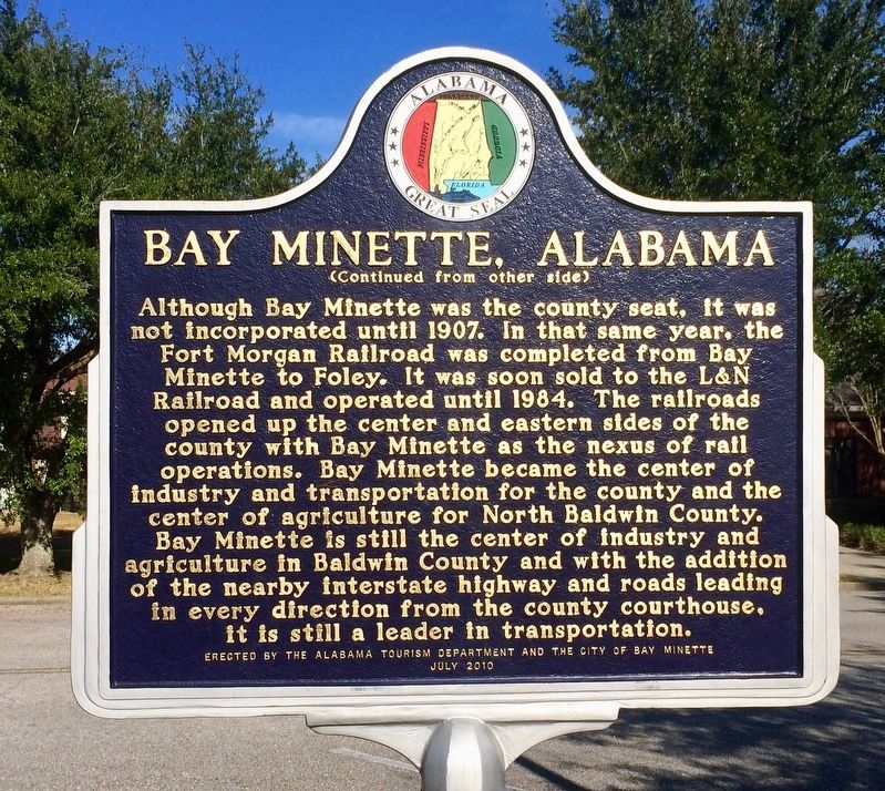
| On North Main Street (Alabama Route 51) 0.6 miles south of West Street, on the right when traveling south. |
| On Main Street (Alabama Route 25) at 1st Street, on the right when traveling south on Main Street. |
| On Lafayette Street North (U.S. 431) just south of Alabama Avenue, on the right when traveling north. |
| On North Lanier Avenue at 1st Street, on the left when traveling north on North Lanier Avenue. Reported missing. |
| On Sand Rock Avenue at Wildcat Street, on the left when traveling north on Sand Rock Avenue. |
| On Main Street Circle west of Main Street South. |
| Near Court Square (Road 31) at 2nd Avenue North, on the right when traveling south. |
| On Alabama Route 22 at Jackson Street, on the right when traveling west on State Route 22. |
| Near County Road 16, 0.4 miles west of Alabama 22, on the right when traveling west. |
| On County Road 293 at County Road 52, on the right when traveling south on County Road 293. |
| On U.S. 31 at Old US Highway 31, on the right when traveling north on U.S. 31. |
| On Alabama Route 95, 0.4 miles south of County Road 48, on the left when traveling south. |
| On U.S. 231 at State Line Road, on the right when traveling north on U.S. 231. |
| On North Oates Street (Business U.S. 231) at West Main Street (Business U.S. 84), on the right when traveling north on North Oates Street. |
| On Main Street at Browntown Road (County Road 47/416), on the left when traveling north on Main Street. |
| On Municipal Lane, on the right when traveling east. |
| On Avenue H at 6th Street, on the right when traveling south on Avenue H. |
| On Rock Creek Road, 0.1 miles south of Port Birmingham Road (Alabama Road 269), on the left when traveling south. |
| On East Mobile Street at North Court Street on East Mobile Street. |
| On South Jefferson Street at Market Street, on the right when traveling north on South Jefferson Street. |
| On Huntsville Highway (U.S. 231/431) at Hunter Road, on the left when traveling north on Huntsville Highway. |
| On U.S. 278 at milepost 66,, 0.2 miles north of Road 2, on the right when traveling north. |
| On North Royal Street at St Michael Street, on the right when traveling north on North Royal Street. |
| On North Conception Street, 0.1 miles north of St Michael Street, on the right when traveling north. |
| On Government Street (U.S. 98) at South Jackson Street, on the right when traveling west on Government Street. |
| Near North Bainbridge Street at Dexter Avenue, on the right when traveling south. |
| On Jefferson Street at Pickens Street, on the right when traveling east on Jefferson Street. |
| On Longview Street at Jackson Street, on the right when traveling north on Longview Street. |
| Near Chapel Street at Longview Street. |
| On Cogswell Avenue at 18th Street, on the right when traveling west on Cogswell Avenue. |
| On 1st Avenue North at 19th Street North, on the right when traveling west on 1st Avenue North. |
| On Lafayette Street (U.S. 11) at Franklin Street, on the right when traveling south on Lafayette Street. |
| On Court Street north of Central Avenue (Alabama Route 56), on the left when traveling north. |
| Near Old Post Road, 0.8 miles south of State Route 169. |
| On North Main Street (U.S. 425) at East Adams Street, on the right when traveling north on North Main Street. |
| On Northeast John Deshields Boulevard, 0.1 miles east of Northeast Martin Luther King, Jr. Parkway, on the right when traveling east. |
| On East Cedar Street at North Main Street (Business U.S. 63), on the right when traveling west on East Cedar Street. |
| Near Main Street at North Lakeshore Drive (Arkansas Highway 144). |
| On Clay Street at South 4th Street, on the right when traveling east on Clay Street. |
| Near County Road 347, on the right when traveling north. |
| On South Moose Street north of East Church Street, on the right when traveling north. |
| On South Bridge Street (Arkansas Route 9) at East Burrow Street, on the right when traveling west on South Bridge Street. |
| On South Main Street at West Washington Avenue, on the right when traveling south on South Main Street. |
| On Arkansas Route 1, 0.1 miles south of Arkansas Route 138. |
| On Arkansas Route 1 at Front Street, on the right when traveling east on State Route 1. |
| On West Commercial Street (Highway 64) at South 2nd Street, on the right when traveling east on West Commercial Street. |
| Near Central Avenue (Arkansas Route 7) at Mountain Street, on the right when traveling south. |
| On U.S. 278 at State Route 26, on the left when traveling north on U.S. 278. |
| On 3rd Street at Main Street, on the right when traveling west on 3rd Street. |
| On U.S. 63/79, 0.1 miles north of Myrtle Street. |
| On East 3rd Street at Spruce Street, on the left when traveling east on East 3rd Street. |
| On County Road 133 at State Route 234, on the right when traveling west on County Road 133. |
| On North 2nd Street north of West Main Street (State Route 32), on the right when traveling north. |
| On Arkansas Route 108 south of Arkansas Route 108 Spur, on the right when traveling south. |
| On West Main Street (Business U.S. 412) at West War Eagle Avenue, on the right when traveling east on West Main Street. |
| On East Old Main Street, on the right when traveling west. |
| On George Street west of East Street, on the right when traveling west. |
| On Church Street just east of Stone Street (State Route 7), on the left when traveling east. |
| On Courthouse Square at North Washington Avenue (State Route 26), on the left when traveling west on Courthouse Square. |
| On West Courthouse Square just west of North 2nd Street, on the right when traveling west. |
| On U.S. 62/67 north of South Bettis Street, on the right when traveling north. |
| On Center Street south of Nome Street, on the right when traveling south. |
| On West Stillwell Avenue at North 3rd Street, on the right when traveling west on West Stillwell Avenue. |
| On South Izard Street south of Court Avenue, on the left when traveling south. |
| On North Washington Avenue at East Elm Street, on the right when traveling north on North Washington Avenue. |
| On U.S. 167 near East State Line Road (East Third Street), on the right when traveling south. |
| On West Arch Avenue at North Spruce Street, on the left when traveling east on West Arch Avenue. |
| On North 3rd Street north of Spruce Street, on the right when traveling north. |
| On Sutter Hill Road at Eureka Road, on the right when traveling west on Sutter Hill Road. |
| On San Pablo Dam Road, on the right when traveling south. |
| On Los Angeles Street west of North Alameda Street, on the right when traveling south. |
| Near Serrano Road at Winding Way, on the right when traveling north. |
| On Needles Highway, 0.1 miles south of Aha Macav Parkway, on the right when traveling north. |
| On Needles Highway, 0.1 miles south of Aha Macav Parkway, on the right when traveling north. |
| On 2nd Street at G Street, on the left when traveling west on 2nd Street. |
| On West Littleton Boulevard at South Court Place, on the right when traveling west on West Littleton Boulevard. |
| On Wilcox Street at 4th Street NE, on the right when traveling south on Wilcox Street. Reported missing. |
| On Colorado Street (County Route 86), on the right when traveling west. |
| On State Highway 52, 0.1 miles north of Interstate 76, on the right when traveling north. |
| Near State Highway 194 east of County Highway 35. |
| On County Road 63.2 at County Road 36, on the right when traveling north on County Road 63.2. |
| On 1st Street at Walnut Street, on the right when traveling east on 1st Street. |
| On 1st. Street at Walnut Street, on the right when traveling east on 1st. Street. |
| On Main Street at Prospect Street, on the right when traveling north on Main Street. |
| On Main Street South (U.S. 6) at Park Road, on the left when traveling north on Main Street South. |
| On Loockerman Plaza west of Federal Plaza, on the right when traveling west. |
| On Forest Avenue (Delaware Route 8), on the right when traveling west. |
| On Rt. 13 just north of Asbury Ave.. |
| On Halltown Road (Delaware Route 8), on the left when traveling west. |
| On Halltown Road (Delaware Route 8), on the right when traveling east. |
| On East Second Street, 0.1 miles north of Delaware Street, in the median. |
| On New London Road Rt. 896 north of Hopkins Bridge Road, on the right when traveling north. |
| On Nottingham Road, on the left when traveling west. |
| On Dupont Parkway, on the right when traveling north. |
| On Lighthouse Road (Delaware Route 54) near Coastal Highway (Delaware Route 1) when traveling south. |
1788 entries matched your criteria. The first 100 are listed above.
Next 100 ⊳