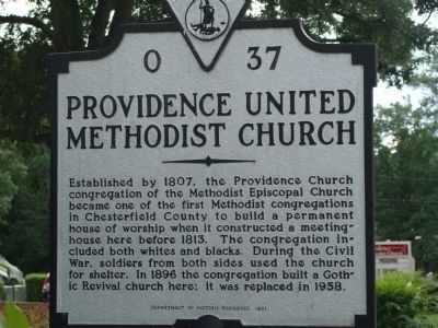
Established by 1807, the Providence Church congregation of the Methodist Episcopal Church became one of the first Methodist congregations in Chesterfield County to build a permanent house of worship when it constructed a meeting house here before . . . — — Map (db m22698) HM
Organized near this spot by Wm. and Daniel Fristoe in 1772. Constituted by elders John Marks and John Garrard, the later serving as its pastor. James Ireland served as pastor from 1778–1806 and is buried here. — — Map (db m1831) HM
Clarke County is proud to be home to two historic driving tours. They include all four of our historically designated towns and villages. Combined with the National Register Historic Districts of which they are part, they make up over 38 percent . . . — — Map (db m157718) HM
In memory of
1746 James Ireland 1806
Minister of the Gospel
Born in Edinburgh, Scotland and converted in Frederick County, Va.
Baptized and ordained at Sandy Creek, N.C. Imprisoned at Culpeper,
Va. for preaching the gospel organizer . . . — — Map (db m221644) HM
Lord Fairfax worshipped here in the “Old Chapel” of colonial Frederick Parish, established 1738. This stone building dates from 1790 and witnessed the early ministry (1810–1885) of Bishop Meade. Governor Edmund Randolph and Col. Nathaniel Burwell . . . — — Map (db m1852) HM
The Virginia General established Frederick Parish in 1738, and a log sanctuary was built here ca. 1747. A stone church, later known as Old Chapel, replaced the log building ca. 1793. The Rev. William Meade served the congregation for about 25 years . . . — — Map (db m230298) HM
Col. Nathaniel Burwell, great-grandson of Robert "King" Carter, constructed Carter Hall in the mid-1790s after moving here from Tidewater Virginia. Edmund Randolph Governor of Virginia, U.S. Attorney General, and U.S. Secretary of State, died here . . . — — Map (db m72942) HM
This 30-square-mile scenic landscape illustrates the evolution of a unique rural community. Unlike the rest of the Shenandoah Valley, where mostly Scots-Irish and German immigrants settled on small farms, Virginia Tidewater gentry occupied most of . . . — — Map (db m1848) HM
1819 Original stone building
1846 Present brick building
1919 Chapel of Grace Church
Annual homecoming service
second Sunday in August — — Map (db m19067) HM
Among the oldest churches in Culpeper, Antioch Baptist Church originated in the 1850's. Separated from the Mount Pony Baptist Church, Antioch was first called "The African Church," organized in 1859. The first congregation, also referred to as free . . . — — Map (db m12687) HM
Built in 1879, this Gothic Revival church stands two miles south of this location. It contains an elaborate example of trompe-l’oeil fresco painting done in 1888. Joseph Dominick Phillip Oddenino, an Italian immigrant artist, painted to . . . — — Map (db m23192) HM
This house
is a contributing building to the
South East Historic District
designated as a
Virginia Historic Landmark
and placed on the
National Register of Historic Places — — Map (db m170731) HM
This area of Downtown Culpeper is historically known as "Sugar Bottom," home to many of Culpeper's black Americans around 1900. Former residents refer to this enclave as a friendly neighborhood, where everybody knew everybody, the church was the . . . — — Map (db m170189) HM
Following the end of the Civil War in 1865, Willis Madden, a free black man of color, built the African Ebenezer Church. The building had a half acre around it, and it was to be "Devoted to the preaching of the Gospel, as long as the colored . . . — — Map (db m185518) HM
This Gothic Revival church, built in 1879, contains an elaborate example of trompe-l’oeil fresco painting done in 1888. Joseph Dominick Phillip Oddenino, an Italian immigrant artist, painted to deceive the eye into believing that his plaster . . . — — Map (db m122068) HM
Crooked Run Baptist Church was organized in 1772 and is named for the stream that flows nearby. James Garnett Sr., one of the early pastors, served the congregation from 1774 until close to his death in 1830. Another member, Thomas Ammon, became a . . . — — Map (db m4737) HM
One-half mile east stands Little Fork Espiscopal Church, begun 1753, destroyed by fire in 1773. Present structure completed in 1776. — — Map (db m2683) HM
Before the creation of independent African American churches throughout Virginia, the enslaved often attended church with their owners. Laws regulating African American gatherings and worship became increasingly strict in the 1830s following "Nat . . . — — Map (db m152626) HM
On October 23, 1833, Pastors Thornton Stringfellow and John Churchill Gordon organized Stevensburg Baptist Church. The congregation elected Stringfellow as the pastor for the new church and split from Mount Pony Baptist Church, which had relocated . . . — — Map (db m152627) HM
The Rev. Reuben T. Coleman, enslaved at birth, became an entrepreneur after the Civil War. About 1.5 miles north of here he established Lucyville, named for his daughter, which in the 1890s featured a bank, post office, newspaper, and mineral . . . — — Map (db m245703) HM
Here at Cumberland Church, in the afternoon of April 7, 1865, part of the Army of Northern Virginia entrenched to protect the route west to Appomattox Station, where supplies awaited the men. The Confederate line, across the road behind you, . . . — — Map (db m171712) HM
After successfully crossing the Appomattox River at nearby High Bridge, Maj. Gen. Andrew A. Humphreys’ II Corps attacked Confederate forces under Maj. Gen. William Mahone that were entrenched on the high ground around Cumberland Presbyterian Church. . . . — — Map (db m11861) HM
Samuel P. Bolling was born enslaved in Cumberland County and became a skilled mechanic. After the Civil War he purchased several lots in Farmville, where he established a successful brickyard by 1874. He later acquired more than 1,000 acres in . . . — — Map (db m238093) HM
The Virginia General Assembly chartered Union Female College, forerunner of Averett University, in 1859. Supported by the Concord, Dan River, and Roanoke Baptist Associations, the school offered preparatory and collegiate instruction to young women. . . . — — Map (db m171815) HM
In 1865 emancipated African Americans withdrew
from First Baptist Church, where they had
worshiped from the balcony, and founded a
congregation later known as High Street Baptist
Church. Members erected their first sanctuary
here in 1873. Fire . . . — — Map (db m104466) HM
The Loyal Street Baptist Church congregation, which was organized between 1865 and 1866 on Old Hospital-Dance Hill by former slaves, built its church here in 1870. Worship continued at this site until 1924 when the congregation moved to Holbrook . . . — — Map (db m66036) HM
This property has been
placed on the
National Register
of Historic Places
by the United States
Department of the Interior
circa 1865
Main Street Methodist
Episcopal Church
has been registered as a
Virginia . . . — — Map (db m171913) HM
The Town of Chatham has served as the seat of Pittsylvania County government since 1777. It is rich in history with architecturally significant pre-Revolution, Federal, Victorian and post-Victorian houses. Brochures for self-guided walking . . . — — Map (db m171909) HM
On 12-15 October 1728, Col. William Byrd II and his party camped just west of here while surveying the Virginia-North Carolina boundary. Bearskin, Byrd's Saponi guide, described his tribe's religious beliefs, which, wrote Byrd in his diary, . . . — — Map (db m66052) HM
Dickenson County.The traditional music of Dickenson County has a
special sound. Based upon tones from the
Primitive Baptist and “Dunkard“ churches, this
sound has influenced singers in the string bands of
the region. The most . . . — — Map (db m90774) HM
Quakers began settling the region by the end of the 17th century. Named for nearby Gravelly Run stream, the meetinghouse was built by 1767. It became the religious center for the Quakers in Dinwiddie and surrounding counties. In the early 1800s the . . . — — Map (db m17662) HM
Butterwood Chapel, one of three Anglican chapels constructed in Dinwiddie County in the 18th century, was built by 1763 on or near this site. It probably was the first church built after the creation of Bath Parish in 1742. The Reverend Devereux . . . — — Map (db m31054) HM
Sapony Episcopal Church stands approximately 1.5 miles to the north. This simple frame building was first constructed in 1725-1726. The Rev. Devereux Jarratt served as rector here and at two other congregations in Dinwiddie County from 1763 until . . . — — Map (db m26841) HM
In front of you is second location where the original church building stood after the Civil War. The first location was east of here and across the Civil War-era Halifax Road (now Acorn Drive). It was built around 1820 and first known as Hubbard's . . . — — Map (db m13793) HM
In 1911 a group of Dinwiddie County’s African-American residents established the Rocky Branch School in Sutherland. The school was a typical two-room schoolhouse. It had been moved from original location across from Ocran Methodist Church on . . . — — Map (db m26833) HM
In 1911 a group of Dinwiddie County's African American residents established the Rocky Branch School in Sutherland. The school was a typical two-room schoolhouse. It had been moved from its original location across the Ocran Methodist Church . . . — — Map (db m180077) HM
Between Ford and Wilsons stations was 22 year old White Oak Methodist Church. The grounds were used as a wayside hospital for Confederate wounded until burned to the ground on June 23, 1864 by Union cavalry. Built in 1862, the hospital contained . . . — — Map (db m83639) HM WM
William McKendree was born in King William County in 1757. He soon moved with his family to present-day Greensville County, and later served in the Revolutionary War. In 1786, the county licensed him to keep a tavern at his house (12 miles south). . . . — — Map (db m18943) HM
Thomas McNeill Bulla was born in North Carolina on 4 Jan. 1881. Ordained a Presbyterian minister, he was called here to the First Presbyterian Church of Emporia in 1911. In April 1917, he became chaplain of the 116th Infantry Regiment, 29th Infantry . . . — — Map (db m18955) HM
In commemoration
of the
Shiloh
Baptist Church
Emporia, Virginia
Shiloh was one of the
first Black churches founded
in Greensville County
It was founded in 1866
under the leadership of
Rev. Ephriam Royal
Shiloh moved . . . — — Map (db m41511) HM
Two miles east near the river, Richard Coleman planted a frontier settlement and trading post in 1652. By 1660 a church was built, to which every man was required to come armed for protection against the Indians. — — Map (db m3085) HM
Angel Visit Baptist Church, one of the oldest African American churches in Essex County, was formed in 1866 when African American members withdrew from white-led Ephesus Baptist Church after Emancipation. The congregation purchased land here in 1867 . . . — — Map (db m194986) HM
Founded by
Southside Rappahannock Baptist Association
Education - The Hope of a Glorious Future
Original Trustees
Willis Brook • Ned Fitzgerald • C. H. Newman • D.R. Page • Thomas Pollard • J. R. Ruffin • N.A. Wiggins • W. E. Robinson - . . . — — Map (db m191128) HM
The Southside Rappahannock Baptist Association opened the Rappahannock Industrial Academy here in 1902 to provide secondary education for African Americans at a time when no public high schools were available to them in the area. Supported by . . . — — Map (db m198433) HM
This was the principal church of St. Anne's Parish, which was formed in 1704 from Sittenburne Parish and encompassed Essex County. According to tradition, part of the present church was built about 1719 with an addition constructed in 1731, but . . . — — Map (db m7407) HM
Founded nearby as Piscataway Baptist Church on 13 Mar. 1774, Mt. Zion Baptist Church was the first Baptist church in the region. Endeavoring to stop the spread of the Baptist movement, local authorities arrested Baptist ministers John Waller, John . . . — — Map (db m7493) HM
Just to the East stood Mann Meeting House, the first Methodist Episcopal Church in this region. It was built before 1794 and abandoned about 1880. The site is now occupied by the Macedonia Colored Baptist Church. — — Map (db m3080) HM
Local residents recall the period through the 1930s when Mount Calvary Baptist Church regularly conducted baptismal services in the Accotink Branch, in the pool formed at its confluence with the Tussico. White-robed candidates were immersed by the . . . — — Map (db m173605) HM
According to tradition, the earliest congregation, which would become the Bethlehem Baptist Church, was organized circa 1863 by Samuel K. Taylor, a former slave, who preached in the homes of the African-American residents of Gum Springs. Shortly . . . — — Map (db m100708) HM
Gum Springs, an African-American community, originated here on a 214-acre farm bought in 1833 by West Ford (ca. 1785-1863), a freed man, skilled carpenter, and manager of the Mount Vernon estate. The freedman’s school begun here in 1867 at Bethlehem . . . — — Map (db m952) HM
Gum Springs, an African-American community, originated here on a 214-acre farm bought in 1833 by West Ford (ca. 1785-1863), a freed man, skilled carpenter, and manager of the Mount Vernon estate. The freedman's school begun here in 1867 at Bethlehem . . . — — Map (db m210268) HM
African Americans in Woodlawn, four miles southwest of here, established Woodlawn Methodist Episcopal Church ca. 1866. The Woodlawn area, formerly part of George Washington's Mount Vernon estate, was home to African Americans who had been free . . . — — Map (db m131212) HM
Saint Mark's Episcopal Church is one of several congregations that evolved from the efforts of nineteenth century students from the Virginia Theological Seminary in Alexandria. The first congregation met at the original Groveton Schoolhouse on . . . — — Map (db m42387) HM
In the early 19th century these 10 acres were part of Burgundy Plantation. In the 1850s, John A. Fairfax established a 150 acre plantation named Fairview on the property. He improved the existing dwelling originally constructed between 1800 and . . . — — Map (db m131551) HM
Mount Pleasant Baptist Church was founded in 1867 during post-Civil War Reconstruction. Freedmen were given one acre of land for religious and educational purposes and a burying ground for colored people. The first church was a one-room . . . — — Map (db m189258) HM
This 152-acre historic district was part of George Washington's Mount Vernon estate. In 1799 Washington gave the Woodlawn tract to his step-granddaughter Eleanor Park Custis and her husband, Lawrence Lewis. Northern Quakers bought the property in . . . — — Map (db m140950) HM
At the turn of the 20th century, a close-knit African American community was established here. The Johnson, Robinson, Sprigg and Collins families were the first to purchase lots. They cleared pine trees to enable truck farming and saw mill . . . — — Map (db m100807) HM
On this site stood Lee Chapel, a Methodist Episcopal Church, built 1871 and named in honor of General Robert E. Lee. Lee Chapel replaced Mount Carmel Church which had been located at Ox Road and present day Lee Chapel Road and had been destroyed by . . . — — Map (db m11) HM
Prior to the Civil War, John and Mary Marshall, early prominent Burke area citizens, bought this land and built a family dwelling on fifty acres of land purchased in 1852. The Marshalls donated land to the Church of the Good Shepherd and to the . . . — — Map (db m198383) HM
Destroyed during the Civil War. Rebuilt 1870. This Marker Presented in Memory of Martha Elliott Saunders by Her Children Otto Frank and Martha 1939
The Edifice Became the Anglican Church of the Ascension on December 23, 1973. — — Map (db m117176) HM
Here, where the Warrenton Turnpike turned west from Braddock Road, the Union army marched from Centreville to meet Confederate forces in the first great battle of the Civil War on July 21, 1861. The afternoon, Union soldiers passed by here again, . . . — — Map (db m173378) HM
Passing armies occupied and fortified Centreville, positioned between Washington, D.C., and Manassas Junction, beginning in July 1861 when Confederate and Union forces met during the war's first significant campaign. As American and British . . . — — Map (db m57135) HM
During the Civil War, 40,000 troops wintered here. After being burned in 1863, the church was rebuilt in 1867 on the same foundation, and then consecrated in 1872. All these years, the parishioners have cherished St. John's Church through its . . . — — Map (db m173367) HM
Alexander Haight, a Quaker who lived at Sully, feared he would be forcibly taken by the Confederate army. The Confederates were looking for able-bodied men and searching for supplies. Alexander was a suspected Union sympathizer. According to . . . — — Map (db m198299) HM
Owned by Rev. Wm. Bradley & his wife Elisabeth, the first Presbyterian Minister in
Clifton, the parents of Margaret Riviere Hetzel, who taught the first School in Clifton
Restored in 1981 — — Map (db m114222) HM
This building was built as a General Mercantile Store and through the years has been occupied as a Saloon, Bakery, Grocery, Pool Hall, Cabinet Shop and Church.
The addition was added in 1926 for a Barber Shop.
The building was . . . — — Map (db m114275) HM
In 1876, George W. Tillet, along with other area men who served with Mosby’s Rangers during the Civil War, formed a Baptist Church with services held in his home. Subsequently, they built a one-room church on this site in 1877 which was replaced by . . . — — Map (db m110179) HM
After the Civil War, residents seeking Christian fellowship and education organized a Sunday School in the Hetzel House at the corner of Chapel and Pendleton streets. In 1869, nine members of the community organized Clifton Presbyterian Church, . . . — — Map (db m110160) HM
Built in 1871 as the Clifton Old School Primitive Baptist Church, it is the oldest African-American church in Fairfax County. The town of Clifton was initially inhabited by emancipated slaves and the church was built on land donated by one of them, . . . — — Map (db m110265) HM
Owned by just two families before its first restoration in 2002 this house was built by J .M. Fulmer just one year after finishing a larger home on Chapel Street next to the Clifton Baptist Church. The Spring House in the front yard once provided . . . — — Map (db m114528) HM
William H. Mathers built this bungalow in the twilight of his life. A successful lumberman, he was president of the Clifton Land Improvement Company. His daughter, Ruth, ultimately deeded the home to the Clifton Presbyterian Church in October 1964 . . . — — Map (db m194493) HM
After the Civil War, a small community of African Americans lived on Route 654, now known as Zion Drive. The Wrights, Hamiltons, Whites, and Pinns were farmers and laborers. In 1904, David R. & Sarah F. Pinn donated an acre of land to build Little . . . — — Map (db m57234) HM
The Legend Story of the First Prayer Wheel
As it was told: "To Bodhisattva Naga King, those who see or hear about the Dharma wheel, talk about it, even think about it or touch it, will soon be separated from the sufferings of the . . . — — Map (db m197301) HM
This sacred World Peace Sand Mandala was created in January 2019 of Drikung Dharma Surya Center by Tibetan Buddhist monks of the Labrang Tashi Kyil Monastery in Dehradun, India.
The sand mandala is constructed my millions of grains of . . . — — Map (db m197295) HM
Here at Fairfax Station in early Sept. 1862, after the Second Battle of Manassas and the action near Chantilly, Clara Barton ministered to the suffering. By her humane and tireless efforts this Angel of the Battlefield helped move over 3000 wounded . . . — — Map (db m102) HM
The founder of
American Red Cross
Clara H. Barton
nursed the wounded and dying
soldiers from the Second Battle
of Manassas and the
engagement near Chantilly — — Map (db m110236) HM
Dedicated September 19, 1858 by Rt. Rev. John McGill, Bishop of Richmond. — Catholic workers, who were employed in building the Fairfax Railroad pass, began work on the structure in 1856. They were assisted by members of the nearby Hamill . . . — — Map (db m184) HM
Welcome to the Fairfax Station Railroad Museum, established in 1987.
Fairfax Station was constructed in 1852 along the Orange and Alexandria Railroad. Formed in 1848, the O&A was the only rail line connecting Alexandria — a major port at the . . . — — Map (db m194560) HM
The Virginia General Assembly incorporated the Alexandria, Mt. Vernon, and Accotink Turnpike Company in March 1856. The road passed here on its roughly nine-mile route from Alexandria to Accotink Creek. Its founders included local slaveholders as . . . — — Map (db m140922) HM
The Woodlawn Quaker Meetinghouse was built from 1851 – 1853 by members of The Religious Society of Friends (Quakers) who in 1846 purchased the 2,000 acre Woodlawn tract as the means to “establish a free-labor colony in a slave . . . — — Map (db m127843) HM
In the early 1880s, former slaves organized a congregation and held church services near a grove of laurel on Beulah Road. The trustees, including Middleton Braxton, George Carroll, Thornton Gray, and William Jasper, were focused on educating the . . . — — Map (db m86181) HM
Mary Lee Castleman, an active member of the St. Timothy's Episcopal Mission, wanted to establish a proper school for girls. She first established the Herndon Seminary on the upper floor of the old mission building, formerly located at the corner of . . . — — Map (db m186873) HM
Constructed in 1872 for a North Methodist Episcopal congregation, this building ushered in a church building period in Herndon. By 1915 six churches served Herndon's growing population around its historic center. After 67 years at this location and . . . — — Map (db m126640) HM
Pine Street was already established when Herndon became a Town in 1879. Its historic mix of uses demonstrated the importance of downtown in providing local services to residents. in the 19th and early 20th centuries it had the largest building in . . . — — Map (db m126639) HM
This circa 1791 Baptist Church standing on its original site represents a continuous tribute to early religious freedom for slave and free together. — — Map (db m5608) HM
Frying Pan Springs Meeting House was erected c. 1791 on land granted by Robert “Counsellor” Carter to a group of “Old School” Baptists. In addition to local farmers the fundamentalist beliefs of its members also attracted free blacks and slaves . . . — — Map (db m5609) HM
The Frying Pan Meeting House, constructed by 1791 on land donated by the Carter family in 1783, was used for Baptist services until 1968. Named for nearby Frying Pan Branch, the church is a rare example of 18th-Century architecture in western . . . — — Map (db m95104) HM
This pin oak replaces the 200 year old oak that was a sapling when the congregation first met in the Frying Pan Meeting House Baptist Church, 1791.
Planted on Arbor Day, April 26, 1991, in celebration of the centennial of the National . . . — — Map (db m197020) HM
Moved to second edifice September 19, 1982 at 13615 Coppermine Road, before moving to third edifice located at 2516 Squirrel Hill Road on May 1, 1999
Mt. Pleasant Baptist Church was organized in 1866 and held services in The Old Floris . . . — — Map (db m126641) HM
The troop transport Dorchester was crossing the North Atlantic. On February 3, 1943, the deadly enemy submarines struck the Dorchester. The tragedy brought shouts of anger cries of fear, and wails of pain. The Four Chaplains gave their life . . . — — Map (db m145014) HM WM
Some of the features shown here that were prominent on Mason Neck in Fairfax County during the marches of the Armies of the American War of Independence, exist today through generations of historic preservation efforts. The rich natural . . . — — Map (db m198378) HM
The circuit rider, with
his Lord, his Bible, and his horse,
brought Methodism to this area in 1830.
Lewis Chapel
The first Methodist Church,
stood on this site from 1857-1953.
— — Map (db m131556) HM
This church is a combination of several structures built on the site of the first Pohick Church (1730–1774), making this one of the earliest sites of a religious institution in Fairfax County. Lewis Chapel, named after a Methodist circuit . . . — — Map (db m204) HM
This building was begun in 1769 and completed by 1774, succeeding an earlier church two miles to the south. It was the Lower Church of Truro Parish, established in 1732, the parish of Mount Vernon and Gunston Hall. George William Fairfax, George . . . — — Map (db m13750) HM
This marker honors the service of the Revolutionary War Patriots and War of 1812 Veterans buried or memorialized on the grounds of historic Pohick Church
Revolutionary War Patriots
Patriot Charles Alexander, Sr •
Patriot Susanna Pearson . . . — — Map (db m168133) HM WM
1081 entries matched your criteria. Entries 201 through 300 are listed above. ⊲ Previous 100 — Next 100 ⊳