On Atlantic Road (Virginia Route 679) 0.1 miles west of Arbuckle Neck Road, on the left when traveling north.
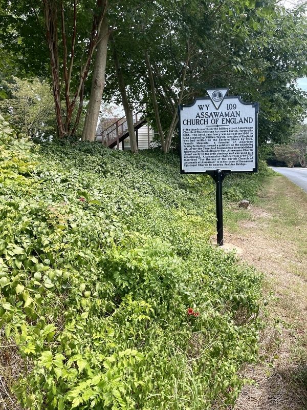
Fifty yards north on the hilltop stood Assawaman Church of the Anglican Accomack Parish, formed in 1663. The brick sanctuary was built after 1680 on land donated by Willam Taylor, a native of England who had settled on the Eastern Shore by 1637. . . . — — Map (db m205005) HM
On Lankford Highway (U.S. 13) at Savagetown Road (Virginia Route 603), on the right when traveling south on Lankford Highway.
The Occohannock Indians, one of the important Virginia Indian groups on the Eastern Shore, were composed of several tribes including the Onancock, Machipongo, Metomkin, Chincoteague, Kegotank, Pungoteague, Chesconessex, and Nandua. Capt. John Smith . . . — — Map (db m71855) HM
On Main Street just west of Post Office Street, on the right when traveling west.
1671
First land purchase from Gingo-Teague Indians recorded on April 1. Oral tradition says the Gingo-Teague called Chincoteague Island "the beautiful land across the water."
1680
Tenant farmer Robert Scott moves to Chincoteague . . . — — Map (db m165061) HM
On U.S. 13 at County Line Road, on the right when traveling north on U.S. 13.
Five miles west is "Hedra Cottage", site of the home of Colonel Edmund Scarborough (Scarburgh), surveyor general of the colony. Beyond, at the end of Scarborough's Neck, was the village of the Occahannock Indians, the seat of Debedeavon, the . . . — — Map (db m7608) HM
On Adams Crossing Road at US 13, on the right when traveling east on Adams Crossing Road.
This first play recorded in the United States was presented August 27, 1665. The Accomack County Court at Pungoteague heard charges against three men “for acting a play,” ordered inspection of costumes and script, but found the men . . . — — Map (db m7613) HM
Near Market Street at College Avenue, on the right when traveling west.
As John Smith helped settle Jamestown, he admired the capabilities of the Native Americans' log canoes. Colonists adopted the log canoe and used iron tools to improve the design. Early canoes were made from a single log, but as the need arose for . . . — — Map (db m165105) HM
On Market Street near South Street, on the left when traveling west.
Known as the Scott Hall Cemetery, it dates from the late 18th century. Here will be found the grave of Commodore Whaley of the Maryland Navy who was killed in the Battle of the Barges in the Chesapeake Bay near the mouth of Onancock Creek in . . . — — Map (db m7681) HM
On US 13 at W. Main Street, on the left when traveling north on US 13.
Two miles west is Onancock, founded in 1680. A courthouse was then built and used for a few years. Militia barracks were there in the Revolution. From Onancock, Colonel John Cropper went to the aid of Commodore Whaley in the last naval action of the . . . — — Map (db m7673) HM
On Market Street, 0.1 miles west of West Street, on the right when traveling west.
Hard by this spot is the site of the home of Francis Makemie the founder of organized Presbyterianism in America who married Naomie Anderson of Accomack County Virginia and established one of his first licensed preaching places here in his Onancock . . . — — Map (db m165101) HM
On Market Street, 0.1 miles west of Mt. Prospect Avenue, on the left when traveling west.
Before railways and highways, the waterways of the Eastern Shore of Virginia were the primary mode of transportation of people and goods. Thus, the Town of Onancock, founded in 1680, grew and flourished. Despite the move to rail and then . . . — — Map (db m165102) HM
On County Line Road at County Line Road, on the right when traveling north on County Line Road.
Accomack County. Area 502 Square Miles. The Eastern Shore was first known as the Kingdom of Accomack, for an Indian tribe. Accomac was one of the original shires formed in 1634. The name was changed to Northampton in 1643. In . . . — — Map (db m7609) HM
On St. George Circle just north of Bobtown Road (Virginia Route 178), on the right when traveling west.
St. George's Episcopal
Church
circa 1738
has been placed on the
National
Register of
Historic Places
by the United States
Department of the Interior — — Map (db m165125) HM
The island was visited in 1608 by Captain John Smith, who gave it the name. A part was patented by Ambrose White in 1670. It was settled in 1686 by John Crockett and his sons’ families. In 1814, it was the headquarters of a British fleet ravaging . . . — — Map (db m46705) HM
On US 13 north of Saxis Road, on the left when traveling north.
Five miles west was the home of the Rev. Francis Makemie, founder of Presbyterianism in the United States. About 1684, Makemie established in Maryland the first Presbyterian Church. Later he moved to Accomac and married. He died here in 1708. — — Map (db m7830) HM
Erected in Gratitude to God And in grateful, remembrance of his servant and minister Francis Makemie, who was born in Ramelton, County Donegal, Ireland, A.D. 1658(?) was educated at Glasgow University, Scotland, and came as an ordained Evangelist to . . . — — Map (db m7838) HM
Commemorates the belief that in this ancient family cemetery were buried near the remains of Francis Makemie, those of his wife Naomi, his daughters Elizabeth and Madame Anne Holden, and his father-in-law, William Anderson. Also those of John . . . — — Map (db m7840) HM
On Gordonsville Road (Virginia Route 231) 1.5 miles Virginia Route 640, on the left when traveling north.
The original house was built in 1765 by Thomas Walker, explorer and pioneer. Tarleton, raiding Charlottesville to capture Jefferson and the legislature, stopped here for breakfast, June 4, 1781. This delay aided the patriots to escape. Castle Hill . . . — — Map (db m22439) HM
Near Monticello Loop north of Thomas Jefferson Parkway (Virginia Route 53), on the left when traveling north.
Mulberry Row’s buildings have all but disappeared—only the remains of four survive. Before re-creating lost buildings and roads, we look at information from many sources. How do we know about this important place and the history of its people, . . . — — Map (db m80863) HM
On Richmond Road (U.S. 250) 0.1 miles west of Louisa Road (Virginia Route 22), on the right when traveling west.
William Randolph patented the Edgehill plantation just to the north, in 1735. His grandson, Thomas Mann Randolph, married Thomas Jefferson's daughter Martha, acquired Edgehill in 1792, and was later governor of Virginia. The couple built a frame . . . — — Map (db m170657) HM
Near Thomas Jefferson Parkway (Virginia Route 53) west of James Monroe Parkway (County Route 795), on the right when traveling east.
Here in 1774, Thomas Jefferson and Philip Mazzei planted Virginia's first commercial vineyard, intending to export their wine back to Europe. The Vineyard was abandon in 1776 with the advent of the Revolutionary War. Jefferson's efforts to grow . . . — — Map (db m188548) HM
Near Monticello Loop north of Thomas Jefferson Parkway (Virginia Route 53), on the left when traveling north.
Jefferson set up a nail-making operation in 1794 to provide income until he could “put my farms into a course of yielding profit.” He calculated the nailers’ daily output, the waste of nailrod, and profits. In its first years, the . . . — — Map (db m80862) HM
Over 200 years ago, four log dwellings stood here. The first, constructed in the 1770s and destroyed by fire ca. 1790. was the "Negro quarter," a large 17 x 34 foot structure intended for multiple enslaved individuals or families. Three identical, . . . — — Map (db m100176) HM
On Ivy Farm Road (County Route 1015), on the left when traveling east.
"In 1779 4,000 prisoners, British and their German auxiliaries, captured at the Battle of Saratoga in 1777, marched over 600 miles to quarters, called 'The Barracks', situated a half mile north of this site. Traditionally, some of these prisoners . . . — — Map (db m37586) HM
On Scottsville Road (Virginia Route 20) 0.5 miles south of Frys Path (Virginia Route 627), on the right when traveling north.
Built before 1744 by
Col. Joshua Fry
1699-1754
Surveyor, Mathematician, Pioneer
Commander-in-Chief of Virginia Forces
French and Indian War
George Washington Inscribed over his Grave
“Here lies the good, the just
and the noble . . . — — Map (db m23244) HM
On Louisa Road (Virginia Route 22) 0.1 miles west of Whitlock Road (Virginia Route 616), on the left when traveling west.
Albemarle County. Albemarle County was formed in 1744 from Goochland County and named for William Anne Keppel, the second Earl of Albemarle, titular governor of Virginia from 1737 to 1754. A portion of Louisa County was later added to . . . — — Map (db m22780) HM
On Gordonsville Road (Route 231) 0.1 miles south of Millwood Lane (County Road 783), on the left when traveling south.
The vestry of Fredericksville Parish commissioned a church for this site in 1745. First known as Middle Church, the wood-frame building was later called Walker's Church. Thomas Jefferson attended the nearby classical school of the Rev. James Maury, . . . — — Map (db m170120) HM
On Virginia Route 231 north of Lindsay Road, on the left when traveling north.
Just north was a classical school conducted by the Rev. James Maury, rector of Fredericksville Parish from 1754 to 1769. Thomas Jefferson was one of Maury’s students. Matthew Fontaine Maury, the “Pathfinder of the Seas,” was Maury’s . . . — — Map (db m17459) HM
On Plank Road (County Route 692) at Monacan Trail Road (U.S. 29), on the right when traveling west on Plank Road.
Named for the community it served. This established church of old St. Anne’s Parish was built on a hill about one half mile east as early as 1769. In 1776 there were plans to build nearby a new, brick church. This new church had not been completed . . . — — Map (db m158048) HM
On Richmond Road (U.S. 250) east of Exit 124 (Interstate 64), on the right when traveling east.
Thomas Jefferson—author of the Declaration of Independence, third president of the United States, and founder of the University of Virginia—was born near this site on 13 April 1743. His father, Peter Jefferson (1708–1757), a surveyor, planter, and . . . — — Map (db m17306) HM
On Thomas Jefferson Highway (Virginia Route 53) just east of Milton Road (County Route 732), on the right when traveling east. Reported permanently removed.
The house was built about 1770 by workmen engaged in building Monticello. Mazzei, an Italian, lived here for some years adapting grape culture to Virginia. Baron de Riedesel, captured at Saratoga in 1777, lived here with his family, 1779–1780. . . . — — Map (db m21952) HM
Near Brenman Park Drive south of Duke Street (Virginia Route 236), on the left when traveling west.
Archaeologists excavated four ship hull remnants along the Alexandria Waterfront — one from the Hotel Indigo Site (44AX229) and three from the Robinson Landing Site (44AX235). Over 200 years ago, Alexandrians repurposed these old merchant ships . . . — — Map (db m216126) HM
On Prince Street west of South Union Street, on the right when traveling west.
George Washington's 1749 Survey shows this lot fronting the Potomac River.
The original house on this site was built in 1783. It was destroyed in the great fire of January 18, 1827, which consumed 53 houses and numerous outbuildings in Old Town. . . . — — Map (db m71794) HM
Near North Lee Street south of Cameron Street, on the left when traveling north.
Alexandria's Changing Shoreline
In 1749 the town of Alexandria was laid out on 10 to 15 foot bluffs around a crescent of shallow water. The back edge of John Carlyle's property, where you are standing now, was about 15 feet above the Potomac . . . — — Map (db m129171) HM
Near North Union Street east of Fayette Alley, on the right when traveling north. Reported missing.
13,000 years ago
The Paleoindian Period
A Native American hunter during the Paleoindian period discards a broken spear point, on a bluff overlooking a tributary to the Potomac River at the southern edge of present-day Alexandria. . . . — — Map (db m166409) HM
On Pioneer Mill Way just east of The Strand, in the median.
Alexandrians created waterfront land by banking out the shoreline using timber cribbing and old ships including three discovered on this site.
For over two centuries this land embodied Alexandria's working waterfront with an evolving mix of . . . — — Map (db m204474) HM
On King Street (Virginia Route 7) at North West Street, on the right when traveling west on King Street.
Alexandria was established by Virginia's colonial assembly in 1749, over four decades the U.S. Congress authorized creation of a national capital on the banks of the Potomac River. Once the final site for the Federal city was selected by President . . . — — Map (db m141166) HM
On Cameron Street east of North Royal Street, on the right when traveling east.
Wording on stone tablet to left:
Alexandria, Virginia
County seat of Fairfax 1742-1800
Organized 13th July, 1749
Incorporated by the Assembly of Virginia 1779
Ceded to the Federal Government 1789
First boundary . . . — — Map (db m167068) HM WM
On North Fairfax Street south of Cameron Street, on the left when traveling south.
This unique building, constructed of stone and set back from the street, was built by John Carlyle, a British merchant and one of the original founders of Alexandria. Witness to both domestic life and war, today the house stands as a museum . . . — — Map (db m156562) HM
On King Street (Virginia Route 7) at North Columbus Street, on the left when traveling east on King Street.
Before the American Revolution, the Church of England was the established church of Virginia and part of the colonial government. For administrative purposes, the colony was divided into "parishes" and all residents paid taxes to maintain church . . . — — Map (db m115716) HM
Near Wharf Street east of Ford's Landing Way, on the right when traveling west. Reported unreadable.
During the 17th century, settlers began to establish small plantations near landing places on the Potomac River. Oceangoing ships could load tobacco and other goods to export to Great Britain. The area that was to become Alexandria was still . . . — — Map (db m127772) HM
The Alexandria waterfront has changed dramatically since the City's founding in 1749. The Potomac River once flowed along the high banks about two blocks west of here near Water (now Lee) Street. Two hundred and fifty years ago, the area where . . . — — Map (db m182672) HM
On South Alfred Street at Downham Way, on the right when traveling south on South Alfred Street.
Organized 1774
Original building erected July 23, 1855
New addition erected October 30, 1972
Housing relics for future generations.
Gift of
Bernard B. Brown — — Map (db m65818) HM
On South Lee Street north of Duke Street, on the right when traveling north.
Trustee of Alexandria 1752 until death in 1765, and was succeeded on board of trustees by George Washington. Member of House of Burgesses and moved the adoption of Patrick Henry's resolution on the "Stamp Act." — — Map (db m131392) HM
On King Street near North St Asaph Street, on the right when traveling west.
George Washington considered Alexandria his hometown after its founding in 1749, and it is here that he came to do business, learn the events of the world, pick up mail, and visit friends. His first association with the town was probably as a 17 . . . — — Map (db m115747) HM
On Cameron Street just west of North Fairfax Street, on the left when traveling west.
When Alexandria was founded in 1749, this corner was planned as the main intersection in the new town, with the streets named in honor of Thomas Fairfax, 6th Lord Fairfax of Cameron, a major land-owner in Northern Virginia. From Cameron Street, . . . — — Map (db m167213) HM
On King Street at North Fairfax Street, on the left when traveling east on King Street.
Alexandria was named for the family of John Alexander, a Virginia planter who in 1669 acquired the tract on which the town began. By 1732, the site was known as Hunting Creek Warehouse and in 1749 became Alexandria, thereafter a major 18th-century . . . — — Map (db m47) HM
On Princess Street at North St. Asaph Street, in the median on Princess Street.
In the 1790's many Alexandria streets were paved with cobblestones. According to legend, Hessian soldiers provided the labor to cobble Princess Street. These cobbles remained essentially untouched until 1979, when the street was restored using the . . . — — Map (db m197474) HM
On Duke Street east of South Fairfax Street, on the right when traveling east.
Close personal friend and family physician of Washington. Surgeon in Braddock's campaign, also with Washington throughout the Revolutionary War. Was at his bedside when he died and received his last messages. — — Map (db m167158) HM
On Prince Street west of South Lee Street, on the right when traveling west.
Was consulting physician in Washington's last illness. At the moment of Washington's death he stopped the bedroom clock, which can be seen in Alexandria Washington Lodge, and conducted the Masonic Funeral service at his grave. — — Map (db m71751) HM
Home of
George Gilpin 1740-1813
Member, Fairfax Committee of Safety
Colonel, Virginia Regiment Fairfax Militia,
Served with General George Washington
in New Jersey campaign and Battle of Germantown
Surveyor of the Town of . . . — — Map (db m115764) HM
On Prince Street at South Saint Asaph Street, on the right when traveling west on Prince Street.
Farm house in Fairfax County, Virginia, located upon part of a seven hundred acre land patent granted to Margaret Brent in 1654. Owned and occupied by descendants of John Douglass Brown and Mary Goulding Gretter since 1816. — — Map (db m71738) HM
On South Royal Street at Jones Point Drive, on the left when traveling south on South Royal Street.
American Indians first frequented Jones Point to hunt and fish. The point is likely named for an early English settler. By the 1790's, military installations were established at Jones point due to its strategic location on the Potomac River. The . . . — — Map (db m79997) HM
On Diagonal Road at King Street (Virginia Route 7), on the left when traveling east on Diagonal Road.
■ a living public art sculpture encompassing the entire park ■ a combination of three garden types: a hanging garden, topiary garden and rain garden ■ the result of an international design competition an important example of . . . — — Map (db m243158) HM
Near North Union Street south of Cameron Street, on the right when traveling north. Reported permanently removed.
Discover the spirit of Alexandria that has been making history for well over two centuries
Founded in 1749, Alexandria was the center of commercial and political activity for early patriots such as George Washington as the seeds of the . . . — — Map (db m115776) HM
On King Street at North Royal Street, on the right when traveling west on King Street.
Alexandria's Market Square was established only a few years after the town was founded in 1749. The site selected was centrally located in a prime block of the colonial settlement, immediately adjacent to the City Hall. At the time, Cameron and . . . — — Map (db m115757) HM
Near South Street near South Washington Street (Virginia Route 400).
On September 6, 1654, this site was included in a patent of 700 acres granted by the Colony of Virginia to Mistress Margaret Brent (c1601–c1671). An extraordinary woman, she spent most of her adult life fighting discrimination of her sex, she was . . . — — Map (db m62020) HM
Near Jones Point Drive, 0.2 miles east of South Lee Street, on the right when traveling east.
Theodore Roosevelt Island
This wooded island is a tribute to the vision of our 26th president. Explore, on foot, 2.5 miles of trails and the memorial plaza.
Lady Bird Johnson Park
Take time to visit the Lyndon Baines Johnson . . . — — Map (db m233790) HM
Near Jones Point Drive, 0.2 miles east of South Royal Street, on the right when traveling east.
Jones Point was once a wooded wilderness, ringed by marshes and periodically cut off from the mainland during high tide. American Indians made use of both woodland and wetland for food, tools and supplies. By the 17th century, Europeans had . . . — — Map (db m62028) HM
On South Fairfax Street south of Prince Street, on the right when traveling north.
Physician General and Director of Hospitals, Middle Department, Continental Army, Charter member, Society of the Cincinnati. Author of the first American Pharmacopoea. President of Board of Trustees of Alexandria Academy, at General Washington's . . . — — Map (db m71757) HM
On King Street at Strand Street, on the left when traveling west on King Street.
Potomac River ferry companies date back to as early as 1740, when Hugo West received permission to operate a ferry from the Hunting Creek warehouse in Prince William over the Potomac River to Fraziers Point in Maryland "...the price for a man 1 . . . — — Map (db m143267) HM
On North Fairfax Street south of Cameron Street, on the left when traveling south.
From March 26 through April 20, 1755, the town of Alexandria served as the center of operations for Major General Edward Braddock, commander-in-chief for British forces in North America. He chose the finest house in town, John Carlyle's, as his . . . — — Map (db m156495) HM
Near North Fairfax Street north of King Street, on the right when traveling north. Reported permanently removed.
The Carlyle House, completed in 1753, was the residence of one of the 18th-century Alexandria's leading citizens—John Carlyle—a prosperous merchant and landowner.
1. Although the earliest known engraving of the Carlyle House appeared . . . — — Map (db m129174) HM
Near Jones Point Drive, 0.2 miles South Royal Street, on the right when traveling east.
From the late 1700s into the 1800s, the pastoral calm of the Point was interrupted repeatedly—by soldiers manning cannon emplacements, by surveyors laying out the boundaries of the nation's capital, by workers at a ropewalk and the lighthouse, . . . — — Map (db m62029) HM
This house was built and owned for twenty years by the Fairfaxes of Belvoir
Col. William Fairfax 1691 ▿▿▿ 1757
Col. George William Fairfax 1724 ▿▿▿ 1787
Patrons Instructors and friends of Washington, . . . — — Map (db m92329) HM
On North Royal Street at Caneron Street, on the right when traveling south on North Royal Street.
This Doorway was returned to Gadsby's Tavern From the Metropolitan Museum by Charles Beatty Moore, Colonel. U.S.A. Retired (1881-1951) in 1949 by the Alexandria Assocation. 1949 marked the Bicentennial of Alexandria's Founding. — — Map (db m71777) HM
On South Union Street just north of Wales Alley, on the right when traveling north.
The pineapple has been a symbol of hospitality since the days of the early American colonies. The legend began with the sea captains of New England, who sailed the Caribbean Islands and returned to the colonies bearing their cargo of fruits, . . . — — Map (db m197473) HM
Three hundred years ago, a river as wide as the Capital Beltway—Great Hunting Creek—emptied into the Potomac River at this spot. In the absence of good roads, this river and its tributaries were vital corridors for travel and trade. . . . — — Map (db m62000) HM
On North Royal Street south of Cameron Street, on the right when traveling south.
The Memorial Fountain in this garden rededicated on June 2, 1967 by The Mount Vernon Chapter National Society of The Daughters of the American Revolution on the occasion of the Dedication of tavern square the fountain was previously located at the . . . — — Map (db m241669) WM
On King Street at North Lee Street, on the left when traveling east on King Street.
From this point, King Street slopes gently down to the Potomac. But when Alexandria was founded in 1749, the new town was perched on a high bluff some 20 feet above the river. The town was established on a shore of a crescent-shaped bay that . . . — — Map (db m115766) HM
On King Street at Fairfax Street, on the left when traveling east on King Street.
Owned by William Ramsay, a founder of Alexandria in July, 1749, and first Mayor. Restored by the City of Alexandria in 1956 and dedicated to the memory of Mrs. Robert Miller Reese (Rebecca Ramsay) (1870–1955), great-great-granddaughter of . . . — — Map (db m144) HM
On King Street east of North Fairfax Street, on the right when traveling west.
Oldest house in Alexandria owned by William Ramsay, a Founder, Trustee, and the first Mayor of Alexandria in 1749. Later occupied by his son Dennis Ramsay and his descendants. Interest in preserving the house was initiated by Edward . . . — — Map (db m115763) HM
Near Jones Point Drive, 0.2 miles east of South Royal Street, on the right when traveling east.
Despite occasional conflicts between European settlers and local Indians, Mistress Margaret Brent of Saint Mary’s City, Maryland, was granted the first land patent on Piper’s Island (later known as Jones Point) in 1654. An extraordinary woman for . . . — — Map (db m62026) HM
Near Diagonal Road (Virginia Route 7) south of King Street (Virginia Route 7), on the right when traveling south. Reported permanently removed.
Welcome to Old Town Alexandria! Experience historical charm with contemporary flair from the river to the rails
Plan
Alexandria Visitors Center at Ramsay House
Knowledgeable staff help you create a perfect plan for your visit. . . . — — Map (db m115143) HM
Near Cameron Street east of North Union Street, on the right when traveling east. Reported permanently removed.
Welcome to Old Town Alexandria! Experience historical charm with contemporary flair from the river to the rails
Plan
Alexandria Visitors Center at Ramsay House
Knowledgeable staff help you create a perfect plan for your . . . — — Map (db m167097) HM
On Cameron Street near North St. Asaph Street, on the left when traveling west.
Replica of Washington's Town House.
Lot purchased by George Washington 1763. House completed 1769 – torn down 1855. Rebuilt by Gov. and Mrs. Richard Barrett Lowe 1960. Bricks & stones from excavation used in construction. Worth . . . — — Map (db m147) HM
On South Pitt Street north of Prince Street, on the right when traveling south.
Built for investment in 1797 by
George Washington
Lot purchased by Washington
in 1763
Conveyed by will in 1799 to
Martha Washington — — Map (db m71716) HM
Near Strand Street just south of Prince Street, on the right when traveling south.
Archaeological Evidence of a Working Seaport
The archaeologists tasked with researching this property on the 200 block of South Union Street used a host of sources such as historic photographs, lithographs, deeds, court cases, newspapers, . . . — — Map (db m195635) HM
Near The Strand at King Street, on the right when traveling north.
(Panel 1)
The Alexandria waterfront reflects the perpetual relationship between people and the Potomac River. The Old Town shore documents a history rich in individual and collective maritime, commercial, and cultural concerns. Waterfront . . . — — Map (db m81244) HM
On North Columbus Street at Cameron Street on North Columbus Street. Reported permanently removed.
Christ Church embodies God's unbounded love by embracing, liberating, and empowering people—whoever you are and wherever you find yourself on your journey of faith.
An Episcopal church designed by James Wren in the colonial Georgian style . . . — — Map (db m129192) HM
On Princess Street at North Washington Street, in the median on Princess Street.
In the 1790's many Alexandria streets were paved with cobblestones. According to legend, Hessian soldiers provided the labor to cobble Princess Street. These cobbles remained essentially untouched until 1979, when the street was restored using the . . . — — Map (db m71813) HM
On Mount Vernon Avenue at East Oxford Avenue, on the right when traveling south on Mount Vernon Avenue.
Prince Hall Masonry originated in Massachusetts in 1775 when a lodge attached to the British army initiated Prince Hall and 14 other free black men as Freemasons. Universal Lodge No. 1, the first Prince Hall lodge in Virginia, was established in . . . — — Map (db m134455) HM
On Potomac Avenue north of East Glebe Road, on the right when traveling north.
Potomac Yard was once part of a vast, wooded landscape overlooking the Potomac River. The original 6,000-acre tract (about 9 square miles) was passed down through generations of the John Alexander family and divided among surviving spouses and . . . — — Map (db m115672) HM
On Payne Street at Wilkes Street, on the right when traveling north on Payne Street.
Original Federal Boundary Stone
District of Columbia
Placed 1791 - 1792
Protected by Mt. Vernon Chapter
Daughters of the American Revolution
1916 — — Map (db m154752) HM
Near Francis Hammond Parkway, 0.2 miles east of Key Drive, on the right when traveling east.
People have lived and worked along Taylor Run for thousands of years. The first Alexandrians probably walked along the stream bank at least 10,000 years ago. These early peoples lived in small, mobile bands and subsisted through hunting and . . . — — Map (db m150807) HM
On Chinquapin Drive, 0.1 miles south of King Street (Virginia Route 7), on the right when traveling north.
Travel the Chinquapin Trek
The Chinquapin trek takes you back in time. Interpretive signs discuss the process associated with the formation of Taylor Run and forest succession. Illustration of trees, plants and wildlife assist you in . . . — — Map (db m150802) HM
On Business Center Drive south of Witter Drive, on the left when traveling north.
James and Mary Bloxham, whose descendants are interred within this cemetery, came to Alexandria from England in the late 18th century. By the mid-19th century, two of their sons — William, a miller by trade, and James (II), a farmer — had settled . . . — — Map (db m216714) HM
On Interstate 64, 0.6 miles east of Jerry's Run Road (Virginia Route 198), on the right when traveling east.
West Virginia. West Virginia was long a part of Virginia. Morgan Morgan began the settlement of the region in 1727. A great battle with the Indians took place at Point Pleasant in 1774. West Virginia became a separate state of the Union in . . . — — Map (db m46376) HM
On U.S. 220, 2.7 miles south of County Route 606, on the right when traveling north.
Three miles west at the mouth of Falling Spring Creek was a post garrisoned by militia under Capt. Robert Breckenridge. Washington inspected it in 1756. It survived an attack by Shawnees under Cornstalk during Pontiac's war in 1763. — — Map (db m1832) HM
On Holly Farms Road (Route 307) west of Thompson Lane, on the right when traveling west.
Nottoway County. Area 310 Square Miles. Formed in 1788 from Amelia, and named for an Indian tribe. Tarleton passed through this county in 1781. Here lived William Hodges Mann, Governor of Virginia 1910-14. (Reverse) Formed in . . . — — Map (db m10220) HM
On South Amherst Highway (U.S. 29) south of North Coolwell Road (County Route 663), on the right when traveling south.
Nearby stood Rucker’s Chapel, one of the first Anglican (present-day Episcopal) churches in Amherst County. Also known as Harris Creek Church and later as St. Matthew’s, the church was founded by Col. Ambrose Rucker before 1751. It stood on part of . . . — — Map (db m46350) HM
If you arrived here by train on a summer Sunday afternoon in the 1870s, you would find crowds of people enjoying Arlington's premier amusement park.
This wooded spot near the confluence of Lubber Run and Four Mile Run was a natural place for a . . . — — Map (db m67491) HM
On Columbia Pike (Virginia Route 244) just east of South Four Mile Run Drive.
Four Mile Run winds through local history–and has been dramatically altered by human impacts.
1. For the region's first inhabitants, the Chesapeake Bay and its tributaries provided transportation and an annual harvest of migratory . . . — — Map (db m151025) HM
On North Glebe Road (Virginia Route 120) just north of Fairfax Drive (Virginia Route 237), on the left when traveling north.
Glebe Road & Ballston
Glebe Road, which passes this site, is one of Northern Virginia's oldest transportation arteries. Its recorded history dates to ca. 1740 when it was known as the "Road to the Falls," taking travelers by land from the . . . — — Map (db m145145) HM
Near Sherman Drive, 0.2 miles south of Lincoln Drive, on the left when traveling south.
In 1778, John Parke Custis purchased most of the 1,100 acres comprising this estate from the Alexander family. John's son, George Washington Parke Custis, came in 1802 and completed the house in 1818. He named it “Arlington” after the old Custis . . . — — Map (db m70738) HM
Near Sherman Road, 0.2 miles south of Lincoln Drive, on the left when traveling south. Reported missing.
Large estates customarily had a vegetable garden and summer kitchen near the main house. Slaves gathered fresh produce, prepared it in the summer kitchen, and carried it directly to the main dining room.
Arlington’s garden extended from the . . . — — Map (db m71606) HM
1655 entries matched your criteria. The first 100 are listed above. Next 100 ⊳