After filtering for Montana, 100 entries match your criteria.
Waterways & Vessels Topic
By Barry Swackhamer, May 12, 2018
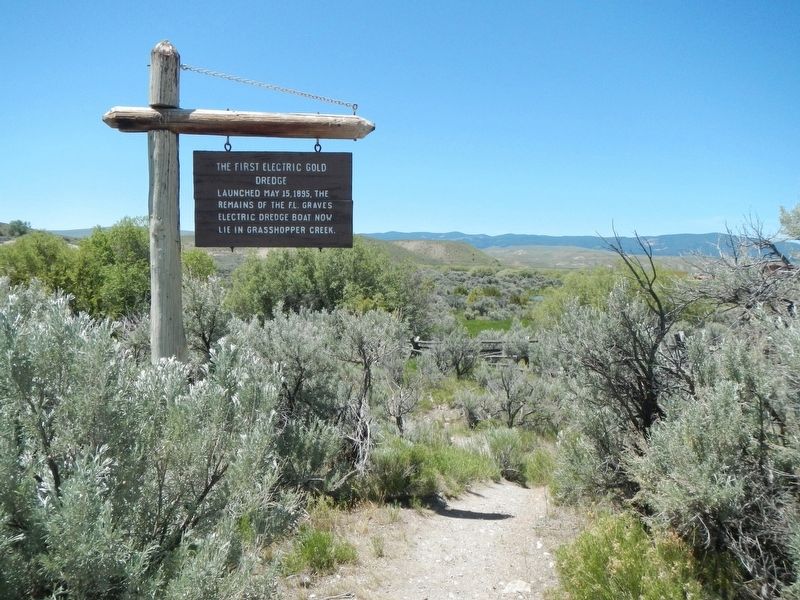
The First Electric Gold Dredge Marker
| 1 ► Montana, Beaverhead County, Dillon — The First Electric Gold Dredge — |
| Near Bannack Road near State Highway 278, on the left when traveling east. | |||
| 2 ► Montana, Beaverhead County, Grant — "Most Distant Fountain" of the Mighty Missouri — |
| Near Lemhi Pass Road near Forest Road 158, on the left when traveling south. | |||
| 3 ► Montana, Beaverhead County, Grant — The Beginning of the "Endless Missouri" — |
| Near Lemhi Pass Road near Forest Road 158, on the left when traveling south. | |||
| 4 ► Montana, Big Horn County, Hardin — Captain Grant Marsh — |
| On Grant Marsh Loop (Road 147) near State Highway 47. | |||
| 5 ► Montana, Broadwater County, Toston — Lewis and Clark Trail — |
| On Toston Dam Road. | |||
| 6 ► Montana, Broadwater County, Townsend — Canyon Ferry — |
| On U.S. 287 near Springville Lane, on the right when traveling north. | |||
| 7 ► Montana, Broadwater County, Townsend — Crimson Bluffs — "...a remarkable bluff of a crimson coloured earth...." — |
| On River Road near Deer Path, on the right when traveling north. | |||
| 8 ► Montana, Carbon County, Bridger — Jim Bridger, Mountain Man — |
| On U.S. 310. | |||
| 9 ► Montana, Cascade County, Great Falls — A "great" Set of Falls — |
| Near Giant Springs Road, 0.9 miles north of River Drive North. | |||
| 10 ► Montana, Cascade County, Great Falls — Black Eagle Falls — |
| On River Drive North, 0.4 miles east of 25th Street North, on the right when traveling west. | |||
| 11 ► Montana, Cascade County, Great Falls — Captain Lewis Arrives at the Great Falls — |
| Near Ryan Dam Road. | |||
| 12 ► Montana, Cascade County, Great Falls — Formation of the Gorge and Falls — |
| Near Ryan Dam Road, 1.6 miles south of Morony Dam Road. | |||
| 13 ► Montana, Cascade County, Great Falls — From Water Comes Power — |
| Near Ryan Dam Road. | |||
| 14 ► Montana, Cascade County, Great Falls — Lewis & Clark Portage Route — June - July 1805 - July, 1806 — |
| On 10th Avenue South (U.S. 87) near 50th Street South, on the right when traveling west. | |||
| 15 ► Montana, Cascade County, Great Falls — Pure Springs Along the Missouri River — |
| Near Giant Springs Road, 1.3 miles north of River Drive North, on the left when traveling north. | |||
| 16 ► Montana, Cascade County, Great Falls — The Army's Navy — |
| Near Giant Springs Road near River Drive North. | |||
| 17 ► Montana, Cascade County, Great Falls — The Experiment — |
| Near Giant Springs Road near River Drive North, on the left when traveling east. | |||
| 18 ► Montana, Cascade County, Great Falls — The Falls: Obstacle or Opportunity — |
| Near Overlook Drive south of 10th Avenue South (Business Interstate 15), on the right when traveling west. | |||
| 19 ► Montana, Cascade County, Great Falls — The Portage Around the Falls — |
| Near Overlook Drive south of 10th Avenue South (Business Interstate 15), on the right when traveling west. | |||
| 20 ► Montana, Cascade County, Great Falls — These Springs Have Witnessed... — |
| Near Giant Springs Road, 1.3 miles north of River Drive North, on the left when traveling north. | |||
| 21 ► Montana, Chouteau County, Carter — Great Falls of the Missouri |
| On U.S. Highway 87 at Carter Road (U.S. 87), on the right when traveling west on U.S. Highway 87. Reported damaged. | |||
| 22 ► Montana, Chouteau County, Fort Benton — Coulson's Steamboat Offices — Coulson Steamboat Lines Largest Company of the Upper River — |
| On River Street near 11th Street, on the right when traveling north. | |||
| 23 ► Montana, Chouteau County, Fort Benton — First Fire Engine House — |
| On Front Street near 15th Street, on the right when traveling east. | |||
| 24 ► Montana, Chouteau County, Fort Benton — Fort Benton — |
| On U.S. 87 near County Road 386, on the right when traveling north. | |||
| 25 ► Montana, Chouteau County, Fort Benton — Fort Benton Historic District — |
| On Front Street near 18th Street, on the left when traveling north. | |||
| 26 ► Montana, Chouteau County, Fort Benton — Fort Benton Levee — |
| On Front Street near 14th Street, on the right when traveling north. | |||
| 27 ► Montana, Chouteau County, Fort Benton — Grand Union Hotel — |
| On Front Street at 14th Street on Front Street. | |||
| 28 ► Montana, Chouteau County, Fort Benton — Grasshoppers in the River? — Perils of Steamboating on the Missouri — |
| Near 7th Street near River Street. | |||
| 29 ► Montana, Chouteau County, Fort Benton — I.G. Baker Home — |
| On Front Street near 17th Street, on the right when traveling north. | |||
| 30 ► Montana, Chouteau County, Fort Benton — June 6, 1908 — |
| On Front Street near 15th Street, on the right when traveling east. | |||
| 31 ► Montana, Chouteau County, Fort Benton — Keelboat Mandan — |
| On Front Street near 17th Street, on the right when traveling north. | |||
| 32 ► Montana, Chouteau County, Fort Benton — Most Progressive in Montana — First in Montana — |
| On River Street near 8th Street, on the right when traveling north. | |||
| 33 ► Montana, Chouteau County, Fort Benton — Steamboat Navigation — |
| On U.S. 87 near County Road 386, on the right when traveling north. | |||
| 34 ► Montana, Chouteau County, Fort Benton — Steamboat Relics — |
| On Front Street near 18th Street. | |||
| 35 ► Montana, Chouteau County, Fort Benton — Stream Flow Monitoring — |
| On Front Street near 15th Street, on the right when traveling east. | |||
| 36 ► Montana, Chouteau County, Fort Benton — T.C. Power & Bro. — |
| On Front Street at 17th Street, on the right when traveling north on Front Street. | |||
| 37 ► Montana, Custer County, Miles City — Riverside Park Steamboats — Miles City Walking Path — |
| Near Main Street near South 5th Street, on the right when traveling east. | |||
| 38 ► Montana, Custer County, Miles City — The Tongue River — |
| On Business Interstate 94 near Garryowen Road, on the right when traveling south. | |||
| 39 ► Montana, Dawson County, Glendive — Clark's Footprints To Eastern Montana's Future — Clark on the Yellowstone — |
| On Montana Avenue just north of State Street, on the left when traveling north. | |||
| 40 ► Montana, Dawson County, Glendive — Evidence Of The Expedition — Clark on the Yellowstone — |
| On Montana Avenue just north of State Street, on the left when traveling north. | |||
| 41 ► Montana, Dawson County, Glendive — Returning To The Plains — Clark on the Yellowstone — |
| On Montana Avenue just north of State Street, on the left when traveling north. | |||
| 42 ► Montana, Dawson County, Glendive — The Yellowstone River — |
| On Bad Route Road (Road 235) near Interstate 94, on the left when traveling south. | |||
| 43 ► Montana, Fergus County, Lewistown — Mackey Building (Montana Tavern) — Lewistown Central Business Historic District — |
| On West Main Street (U.S. 87) at 2nd Avenue North, on the right when traveling west on West Main Street. | |||
| 44 ► Montana, Fergus County, Roy — The Mighty Missouri - Lifeblood of the Plains — |
| Near U.S. 191, on the right when traveling north. | |||
| 45 ► Montana, Fergus County, Winifred — The Judith Landing — |
| On PN Bridge Road (State Highway 236), on the right when traveling south. | |||
| 46 ► Montana, Flathead County, Kalispell — Conrad Mansion — Historic Site Museum — |
| On Woodland Avenue near 3rd Street East, on the right when traveling south. | |||
| 47 ► Montana, Flathead County, Kalispell — Dunsire House — East Side Historic District — |
| On 2nd Avenue East at 6th Street East, on the right when traveling south on 2nd Avenue East. | |||
| 48 ► Montana, Flathead County, West Glacier — Historic Boats — |
| Near Lake McDonald Lodge Loop, 0.1 miles west of Going-To-The-Sun-Road. | |||
| 49 ► Montana, Gallatin County, Bozeman — Lewis and Clark — To the Headwaters — |
| Near N. 19th Avenue near I-90 eastbound entrance ramp (at milepost 305), 0.1 miles east of N. 19th Ave. and E. Valley Center Rd., on the left when traveling south. | |||
| 50 ► Montana, Gallatin County, Three Forks — Colter’s Run — |
| On Trident Road (State Highway 296), on the right when traveling north. | |||
| 51 ► Montana, Gallatin County, Three Forks — Gallatin City — First and Second — |
| On Frontage Road (County Route 205), on the right when traveling east. | |||
| 52 ► Montana, Gallatin County, Three Forks — Jefferson’s Instructions to Lewis and Clark — July 4th, 1803 — |
| On Trident Road (County Route 286), on the left when traveling north. | |||
| 53 ► Montana, Gallatin County, Three Forks — Lewis & Clark Arrive at the Headwaters July, 1805 — |
| On North Main Street at Cottonwood, on the left when traveling north on North Main Street. | |||
| 54 ► Montana, Gallatin County, Three Forks — Lewis and Clark reach the Headwaters — July 25 & July 27, 1805 — |
| Near Trident Road. | |||
| 55 ► Montana, Gallatin County, Three Forks — Missouri River Headwaters — |
| On Frontage Road (County Route 205), on the right when traveling east. | |||
| 56 ► Montana, Gallatin County, Three Forks — The Naming of a River — The Headwaters of the Missouri River — |
| On Trident Road (County Route 286), on the left when traveling north. | |||
| 57 ► Montana, Gallatin County, Three Forks — The Upper Missouri — Along the route of Lewis & Clark — |
| Near Trident Road near Carpenter Road, on the left when traveling north. | |||
| 58 ► Montana, Lewis and Clark County, Craig — "nearer than the route we Came" — |
| On Interstate 15 at milepost 240 near Bald Eagle Drive, on the right when traveling south. | |||
| 59 ► Montana, Lewis and Clark County, Craig — The Dearborn – Ancient Interstate Highway — A shortcut missed — |
| On Marshall Lane near Craig Frontage Road. | |||
| 60 ► Montana, Lewis and Clark County, Helena — U.S.S. Helena — |
| Near South Last Chance Gulch near East Broadway Street, on the right when traveling north. | |||
| 61 ► Montana, Lewis and Clark County, Wolf Creek — Remembering Governor Forrest H. Anderson — |
| On Frank Street near Bridge Street, on the left when traveling south. | |||
| 62 ► Montana, Madison County, Twin Bridges — "...a handsome little river..." — |
| Near Fairgrounds Loop Road near State Highway 41. | |||
| 63 ► Montana, Madison County, Twin Bridges — Which way did they go? — |
| Near Fairgrounds Loop Road at State Highway 41. | |||
| 64 ► Montana, McCone County, Brockway — Fort Peck Dam and Lake — |
| On Highway 200 at milepost 248 at South Flowing Wells Road, on the left when traveling west on Highway 200. | |||
| 65 ► Montana, Missoula County, Missoula — Name That River — Captain Lewis in the Missoula Valley — |
| Near Carousel Drive near South Higgins Avenue. | |||
| 66 ► Montana, Missoula County, Missoula — Rattlesnake Creek — |
| Near Maurice Avenue north of South 5th Street East when traveling north. | |||
| 67 ► Montana, Missoula County, Missoula — Twilight of an Era — |
| On Montana Highway East (State Highway 200) near 1st Street, on the right when traveling west. | |||
| 68 ► Montana, Park County, Livingston — "Wide bold, rapid and deep" — Clark on the Yellowstone — |
| On River Drive near South Yellowstone Street, on the right when traveling west. | |||
| 69 ► Montana, Park County, Livingston — Captain Clark and the Corps of Discovery on the Yellowstone — |
| On Interstate 90 at milepost 325, on the right when traveling east. | |||
| 70 ► Montana, Park County, Livingston — Heading down the Yellowstone — Clark on the Yellowstone — |
| On U.S. 89 near Alpenglow Lane, on the right when traveling east. | |||
| 71 ► Montana, Park County, Wilsall — Shields River Valley — |
| On U.S. 89, 0.5 miles south of Flathead Creek Road (State Highway 86), on the left when traveling south. | |||
| 72 ► Montana, Powder River County, Broadus — The Powder River Country — |
| On U.S. 212 near Big Powder River East, on the left when traveling north. | |||
| 73 ► Montana, Prairie County, Terry — Prairie County — |
| On Ten Mile Road just north of Park Street, on the left when traveling north. | |||
| 74 ► Montana, Roosevelt County, Wolf Point — Wolf Point — |
| On U.S. 2 at Blaine Street, on the right when traveling east on U.S. 2. | |||
| 75 ► Montana, Sanders County, Paradise — Coursing Through Miles Of Montana — Clark Fork Corridor: The River — |
| On State Highway 135, 1.2 miles south of State Highway 200, on the right when traveling south. | |||
| 76 ► Montana, Sanders County, Paradise — The Earth's Blood Flows Past You — Clark Fork Corridor: The River — |
| On State Highway 135, 3.3 miles south of State Highway 200, on the right when traveling south. | |||
| 77 ► Montana, Stillwater County, Columbus — Columbus — |
| Near Interstate 90 at milepost 419, on the right when traveling west. | |||
| 78 ► Montana, Stillwater County, Columbus — Park City — |
| Near Interstate 90 at milepost 419, on the right when traveling east. | |||
| 79 ► Montana, Stillwater County, Park City — The Great Inland Seaway — |
| On Interstate 90 at milepost 419,, 0.2 miles west of Ronan Ranch Road underpass beneath westbound I-90, on the left when traveling west. | |||
| 80 ► Montana, Sweet Grass County, Big Timber — Elk, Rochejhone, Yellowstone — |
| Near Howie Road near U.S. 191. | |||
| 81 ► Montana, Sweet Grass County, Big Timber — The Wild River — |
| On Howie Road near U.S. 191, on the right when traveling west. | |||
| 82 ► Montana, Sweet Grass County, Greycliff — Captain Wm. Clark — |
| On Interstate 90 at milepost 381,, 4 miles west of Bridger Creek Road and I-90 Interchange (Exit 384), on the right when traveling west. | |||
| 83 ► Montana, Valley County, Fort Peck — Diverting the Mighty Missouri — Around Fort Peck Dam — |
| Near Yellowstone Road near Winter Harbor, on the left when traveling east. | |||
| 84 ► Montana, Valley County, Fort Peck — Fort Peck Dam — A Symbol of Hope — |
| On Yager Road at State Highway 24, on the left when traveling south on Yager Road. | |||
| 85 ► Montana, Valley County, Fort Peck — In Memory — |
| On Yaeger Road at State Highway 24, on the left when traveling north on Yaeger Road. | |||
| 86 ► Montana, Valley County, Fort Peck — Powerful Afterthoughts — Hydroelectric Power at Fort Peck Dam — |
| Near Yellowstone Road near Winter Harbor, on the left when traveling east. | |||
| 87 ► Montana, Valley County, Fort Peck — The Slide of '38 — The Day the Dam Gave Way — |
| On Yager Road at State Highway 24, on the left when traveling south on Yager Road. | |||
| 88 ► Montana, Yellowstone County, Billings — Lewis and Clark Yellowstone River Journey — |
| On 6th Avenue North. | |||
| 89 ► Montana, Yellowstone County, Billings, North Park — Where the River Meets the Rims — |
| Near Chief Black Otter Trail near Rimtop Drive. | |||
| 90 ► Montana, Yellowstone County, Billings, South Side — All We Need is Some Water — Building the Big Ditch — |
| Near Montana Avenue (Business Interstate 90) near North 23rd Street, on the right when traveling east. | |||
| 91 ► Montana, Yellowstone County, Billings, South Side — Steamboat City on the River — Coulson Bypassed by Railroad — |
| Near Montana Avenue (Business Interstate 90) near North 23rd Street, on the right when traveling east. | |||
| 92 ► Montana, Yellowstone County, Billings, South Side — The Yellowstone River — The Lifeblood of the Plains — |
| On Montana Avenue (Business Interstate 90) near North 23rd Street. | |||
| 93 ► Montana, Yellowstone County, Worden — Buffalo: Then and Now — August 1, 1806 Encampment — |
| Near State Highway 312 near South 31st Road, on the right when traveling west. | |||
| 94 ► Montana, Yellowstone County, Worden — Clark's Canoe Camp on the Yellowstone, Archaeology Study — |
| Near State Highway 312 near South 31st Road, on the right when traveling west. | |||
| 95 ► Montana, Yellowstone County, Worden — Injury Forces a Halt to Build Canoes — July 19, 1806 Canoe Camp — |
| Near State Highway 312 near South 31st Road, on the right when traveling west. | |||
| 96 ► Montana, Yellowstone County, Worden — Making Canoes, Then and Now — |
| On State Highway 312 near South 31st Road. | |||
| 97 ► Montana, Yellowstone County, Worden — Preparations of Continuing the Trip — July 20-23, 1806 Canoe Camp — |
| Near State Highway 312 near South 31st Road, on the right when traveling west. | |||
| 98 ► Montana, Yellowstone County, Worden — The "Yellowstone River" Walkway — Clark on the Yellowstone River — July 15-August 3, 1806 — |
| Near State Highway 312 near South 31st Road, on the right when traveling west. | |||
| 99 ► Montana, Yellowstone County, Worden — Triumph and Torment — August 3, 1806 Encampment — |
| Near State Highway 312 near South 31st Road, on the right when traveling west. | |||
| 100 ► Montana, Yellowstone County, Worden — Using Modern Mapping Technology to Help Solve a 200 Year-Old Mystery — |
| Near U.S. 312 near South 31st Road, on the right when traveling west. | |||