After filtering for Montana, 135 entries match your criteria. The first 100 are listed. ⊳
US Indian Wars Topic
By Barry Swackhamer, August 7, 2009
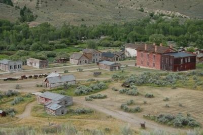
Bannack viewed from the Bannack Cemetery
| 1 ► Montana, Beaverhead County, Dillon — Nez Perce Camp — |
| Near Bannack Road. | |||
| 2 ► Montana, Beaverhead County, Wisdom — A Perfect Place to Rest — |
| Near Park Entrance Road near State Highway 43, on the left when traveling east. | |||
| 3 ► Montana, Beaverhead County, Wisdom — Battlefield Landscape — |
| Near Park Entrance Road near State Highway 43, on the left when traveling east. | |||
| 4 ► Montana, Beaverhead County, Wisdom — Big Hole National Battlefield Monument — |
| On Park Entrance Road near State Highway 43, on the left when traveling north. | |||
| 5 ► Montana, Beaverhead County, Wisdom — Brave Warriors — |
| Near Park Entrance Road near State Highway 43, on the left when traveling north. | |||
| 6 ► Montana, Beaverhead County, Wisdom — Natural Travel Corridor — On the Eve of Tragedy — Trail Creek — |
| On State Highway 43 at Bitterroot-Big Hole Road, on the left when traveling east on State Highway 43. | |||
| 7 ► Montana, Beaverhead County, Wisdom — Siege Site — |
| Near Park Entrance Road near State Highway 43, on the left when traveling east. | |||
| 8 ► Montana, Big Horn County, Busby — Rosebud Battlefield — |
| On State Highway 314. | |||
| 9 ► Montana, Big Horn County, Busby — Two Moons — |
| On U.S. 212, 0.2 miles south of Russell Lane, on the right when traveling south. | |||
| 10 ► Montana, Big Horn County, Crow Agency — 1984 Archeological Survey — Little Bighorn Battlefield — |
| On Little Bighorn Battlefield Road, on the right when traveling north. | |||
| 11 ► Montana, Big Horn County, Crow Agency — Bear Paw Memorial — |
| On Little Bighorn Battlefield Road, on the right when traveling south. | |||
| 12 ► Montana, Big Horn County, Crow Agency — Bear Paw Monument — 1881 — |
| Near Little Bighorn Battlefield Road, on the right when traveling south. | |||
| 13 ► Montana, Big Horn County, Crow Agency — Calhoun Hill — (Little Bighorn Battlefield) — |
| On Little Bighorn Battlefield Road. | |||
| 14 ► Montana, Big Horn County, Crow Agency — Calhoun Hill — Little Bighorn Battlefield — |
| On Little Bighorn Battlefield Road, on the right when traveling north. | |||
| 15 ► Montana, Big Horn County, Crow Agency — Cheyenne Warrior Markers — Little Bighorn Battlefield — |
| On Little Bighorn Battlefield Road. | |||
| 16 ► Montana, Big Horn County, Crow Agency — Companies C & E — (Little Bighorn Battlefield) — |
| On Little Bighorn Battlefield Road. | |||
| 17 ► Montana, Big Horn County, Crow Agency — Companies F and I — (Little Bighorn Battlefield) — |
| 18 ► Montana, Big Horn County, Crow Agency — Crow's Nest — June 25, 1876 — Morning — |
| On U.S. 212, 1 mile east of Interstate 90. | |||
| 19 ► Montana, Big Horn County, Crow Agency — Custer Last Seen — (Little Bighorn Battlefield) — |
| On Little Bighorn Battlefield Road. | |||
| 20 ► Montana, Big Horn County, Crow Agency — Custer’s Advance — Little Bighorn Battlefield — |
| On Little Bighorn Battlefield Road, on the right when traveling south. | |||
| 21 ► Montana, Big Horn County, Crow Agency — Deep Coulee — Little Bighorn Battlefield — |
| On Little Bighorn Battlefield Road, on the right when traveling north. | |||
| 22 ► Montana, Big Horn County, Crow Agency — Deep Ravine — Little Bighorn Battlefield — |
| Near Little Bighorn Battlefield Road, on the right when traveling south. | |||
| 23 ► Montana, Big Horn County, Crow Agency — Deep Ravine — Little Bighorn Battlefield — |
| On Little Bighorn Battlefield Road, on the right when traveling north. | |||
| 24 ► Montana, Big Horn County, Crow Agency — Greasy Grass Ridge — Little Bighorn Battlefield — |
| On Little Bighorn Battlefield Road, on the right when traveling north. | |||
| 25 ► Montana, Big Horn County, Crow Agency — Indian Encampment — Little Bighorn Battlefield — |
| On Little Bighorn Battlefield Road, on the right when traveling south. | |||
| 26 ► Montana, Big Horn County, Crow Agency — Indian Memorial — Little Bighorn Battlefield — |
| On Little Bighorn Battlefield Road, on the right when traveling north. | |||
| 27 ► Montana, Big Horn County, Crow Agency — Keogh – Crazy Horse Fight — Little Bighorn Battlefield — |
| On Little Bighorn Battlefield Road, on the right when traveling north. | |||
| 28 ► Montana, Big Horn County, Crow Agency — Lame White Man Charge — Little Bighorn Battlefield — |
| On Little Bighorn Battlefield Road, on the right when traveling north. | |||
| 29 ► Montana, Big Horn County, Crow Agency — Last Stand Hill, June 25, 1876 — Little Bighorn Battlefield — |
| On Little Bighorn Battlefield Road, on the left when traveling north. | |||
| 30 ► Montana, Big Horn County, Crow Agency — Little Bighorn Battlefield — |
| On Little Bighorn Battlefield Road, in the median. | |||
| 31 ► Montana, Big Horn County, Crow Agency — Little Bighorn Battlefield National Monument — |
| Near Interstate 90 at milepost 510 near U.S. 212. | |||
| 32 ► Montana, Big Horn County, Crow Agency — Little Bighorn Indian Memorial — |
| On Little Bighorn Battlefield Road, on the left when traveling north. | |||
| 33 ► Montana, Big Horn County, Crow Agency — Lone Tipi — June 25, 1876 — Approximately 2:00 p.m. — |
| Near U.S. 212, 1 mile east of Interstate 90. | |||
| 34 ► Montana, Big Horn County, Crow Agency — Medicine Tail Coulee — Little Bighorn Battlefield — |
| On Little Bighorn Battlefield Road, on the right when traveling north. | |||
| 35 ► Montana, Big Horn County, Crow Agency — Medicine Tail Coulee Ford — (Little Bighorn Battlefield) — |
| On Little Bighorn Battlefield Road. | |||
| 36 ► Montana, Big Horn County, Crow Agency — Medicine Tail Ford — Little Bighorn Battlefield — |
| On Little Bighorn Battlefield Road, on the right when traveling north. | |||
| 37 ► Montana, Big Horn County, Crow Agency — Memorial Markers — Little Bighorn Battlefield — |
| On Little Bighorn Battlefield Road, on the left when traveling north. | |||
| 38 ► Montana, Big Horn County, Crow Agency — Peace Through Unity — Little Bighorn Battlefield — |
| On Little Bighorn Battlefield Road, on the right when traveling north. | |||
| 39 ► Montana, Big Horn County, Crow Agency — Reno’s Retreat — Little Bighorn Battlefield — |
| On Little Bighorn Battlefield Road, on the right when traveling south. | |||
| 40 ► Montana, Big Horn County, Crow Agency — Reno’s Valley Fight — Little Bighorn Battlefield — |
| On Little Bighorn Battlefield Road, on the right when traveling south. | |||
| 41 ► Montana, Big Horn County, Crow Agency — Reno's Skirmish Line - Warrior Counterattack — June 25, 1876 — Approximately 3:00 p.m. — |
| Near U.S. 212, 1 mile Interstate 90. | |||
| 42 ► Montana, Big Horn County, Crow Agency — Retreat Crossing — June 25, 1876 — Approximately 4:00 p.m. — |
| Near U.S. 212, 1 mile east of Interstate 90. | |||
| 43 ► Montana, Big Horn County, Crow Agency — Seventh Cavalry Horse Cemetery — |
| Near U.S. 212, 1 mile east of Interstate 90. | |||
| 44 ► Montana, Big Horn County, Crow Agency — Sharpshooter Ridge — |
| Near U.S. 212, 1 mile east of Interstate 90. | |||
| 45 ► Montana, Big Horn County, Crow Agency — The Reno-Benteen Defense — June 25-26, 1876 — |
| Near U.S. 212, 1 mile east of Interstate 90. | |||
| 46 ► Montana, Big Horn County, Crow Agency — Timber Fight — June 25, 1876 — Approximately 3:15 - 3:55 p.m. — |
| Near U.S. 212, 1 mile east of Interstate 90. | |||
| 47 ► Montana, Big Horn County, Crow Agency — Weir Point — Little Bighorn Battlefield — |
| On Little Bighorn Battlefield Road, on the right when traveling north. | |||
| 48 ► Montana, Big Horn County, Crow Agency — Weir Point Fight — (Little Bighorn Battlefield) — |
| On Little Bighorn Battlefield Road. | |||
| 49 ► Montana, Big Horn County, Crow Agency — Wooden Leg Hill — June 25, 1876 — |
| Near U.S. 212, 1 mile east of Interstate 90. | |||
| 50 ► Montana, Big Horn County, Decker — General Crook's Troops — (Rosebud Battlefield/Where the Girl Saved Her Brother) — |
| Near Rosebud Road near State Highway 314, on the right when traveling west. | |||
| 51 ► Montana, Big Horn County, Decker — The Time When The People Fought The Soldiers. — |
| Near Rosebud Road near State Highway 314, on the right when traveling west. | |||
| 52 ► Montana, Big Horn County, Decker — The Way They Saw It — (Rosebud Battlefield/Where the Girl Saved Her Brother) — |
| Near Rosebud Road near State Highway 314, on the right when traveling west. | |||
| 53 ► Montana, Big Horn County, Garryowen — Garryowen — |
| On Garryowen Road, on the right when traveling south. | |||
| 54 ► Montana, Big Horn County, Garryowen — Garryowen, Montana - Sitting Bull’s Camp — |
| On Frontage Road (Interstate 90 at milepost 514), on the left when traveling south. | |||
| 55 ► Montana, Big Horn County, Garryowen — Tomb of the Unknown Soldier — |
| On I-90 Frontage Road, on the left when traveling south. | |||
| 56 ► Montana, Big Horn County, Hardin — Captain Ball's Scout — |
| On State Highway 47 near Mehling Road. | |||
| 57 ► Montana, Big Horn County, Hardin — Captain Grant Marsh — |
| On Grant Marsh Loop (Road 147) near State Highway 47. | |||
| 58 ► Montana, Big Horn County, Hardin — Fort Custer — |
| On East 3rd Street. | |||
| 59 ► Montana, Big Horn County, Wyola — Hay-Corral Battle — Hayfield Fight — |
| On Warman Loop (County Road 40A) near State Highway 313, on the left when traveling north. | |||
| 60 ► Montana, Blaine County, Chinook — ćáynim?a•lika?spe — Bear Paw Battlefield Trail — |
| On Cleveland Road (County Road 240) near S-B Road, on the left when traveling south. | |||
| 61 ► Montana, Blaine County, Chinook — Bear Paw Battlefield — C'Aynnim 'Alikinwaaspa — |
| On Cleveland Road (County Road 240) near S-B Road, on the left when traveling south. | |||
| 62 ► Montana, Blaine County, Chinook — Bear's Paw Battleground — |
| On Cleveland Road (County Road 240) near S-B Road, on the right when traveling south. | |||
| 63 ► Montana, Blaine County, Chinook — Brave Warriors Chief Joseph's Band — |
| Near Cleveland Road (County Road 240) near S-B Road. | |||
| 64 ► Montana, Blaine County, Chinook — Chief Joseph’s Surrender — October 5, 1887 11:00 a.m. — |
| Near Cleveland Road (County Road 240) near S-B Road. | |||
| 65 ► Montana, Blaine County, Chinook — Last Battle — |
| On Cleveland Road (County Road 240) near S-B Road, on the left when traveling south. | |||
| 66 ► Montana, Blaine County, Chinook — McWhorter Stakes — Bear Paw Battlefield — |
| Near Cleveland Road (Montana Route 240) near S-B Road. | |||
| 67 ► Montana, Blaine County, Chinook — Nez Perce Encampment — |
| Near Cleveland Road (County Road 240) near S-B Road. | |||
| 68 ► Montana, Blaine County, Chinook — Nez Perce National Historical Park — |
| On Cleveland Road (County Road 240) near S-B Road, on the left when traveling south. | |||
| 69 ► Montana, Blaine County, Chinook — No Place to Hide — |
| Near Cleveland Road (County Road 240) near S-B Road. | |||
| 70 ► Montana, Blaine County, Chinook — Soldier Burials — |
| Near Cleveland Road (County Road 240) near S-B Road. | |||
| 71 ► Montana, Blaine County, Chinook — Surrender of Chief Joseph — |
| On Cleveland Road (County Road 240) near S-B Road, on the left when traveling north. | |||
| 72 ► Montana, Blaine County, Chinook — The Battle of Bears Paw — |
| On 1st Street (U.S. 2) near Cleveland Road West, on the right when traveling east. | |||
| 73 ► Montana, Cascade County, Fort Shaw — Fort Shaw — |
| On State Highway 200, 0.2 miles west of Dr Russell Road, on the right when traveling west. | |||
| 74 ► Montana, Chouteau County, Big Sandy — Tale of Two Treaties — Cultures Clash, Relationships Change — |
| Near Judith Landing Road (State Highway 236). | |||
| 75 ► Montana, Chouteau County, Fort Benton — Cow Island Incident — |
| Near 8th Street near River Street. | |||
| 76 ► Montana, Chouteau County, Fort Benton — Fort Benton and the Indian Wars — |
| On Front Street near 18th Street, on the left when traveling north. | |||
| 77 ► Montana, Chouteau County, Fort Benton — Nez Perce Fight — 1877 Cow Island Fight — |
| On River Street near 10th Street, on the right when traveling north. | |||
| 78 ► Montana, Chouteau County, Fort Benton — Nez Perce War — |
| On Front Street near 18th Street, on the right when traveling east. | |||
| 79 ► Montana, Chouteau County, Loma — Ophir — |
| Near Loma Ferry Road near Curlew Trail. | |||
| 80 ► Montana, Chouteau County, Loma — Victims of Blood Indian Massacre — |
| On U.S. 87 near Lower Marias/Loma Ferry Roads, on the left when traveling north. | |||
| 81 ► Montana, Custer County, Miles City — Custer's First Skirmish With The Lakota — |
| On Water Plant Road near Logan Drive, on the left when traveling north. | |||
| 82 ► Montana, Custer County, Miles City — Powder River — |
| On U.S. 12, 24 miles east of U.S. I-94, on the left when traveling east. | |||
| 83 ► Montana, Custer County, Miles City — The Tongue River — |
| On Business Interstate 94 near Garryowen Road, on the right when traveling south. | |||
| 84 ► Montana, Fergus County, Lewistown — The Nez Perce Conflict of 1877 — Trading Post at Lewistown — The Exile — |
| On U.S. 87 near H Street, on the left when traveling west. | |||
| 85 ► Montana, Fergus County, Winifred — Camp Cooke — First Military Post in Montana — |
| On PN Bridge Road (State Highway 236), on the right when traveling south on PN Bridge Road. | |||
| 86 ► Montana, Flathead County, Kalispell — Conrad Mansion — Historic Site Museum — |
| On Woodland Avenue near 3rd Street East, on the right when traveling south. | |||
| 87 ► Montana, Gallatin County, Bozeman — Fort Ellis — |
| On Old Route 191 at Fort Ellis Road when traveling east on Old Route 191. | |||
| 88 ► Montana, Glacier County, Cut Bank — Cut Bank International Airport — |
| On Valier Highway (State Highway 358 at milepost 26), on the right when traveling south. | |||
| 89 ► Montana, Golden Valley County, Ryegate — Chief Joseph — |
| On Railway Avenue East (U.S. 12) near Third Street North, on the right when traveling west. | |||
| 90 ► Montana, Granite County, Philipsburg — Jones' Run For Life — |
| On East Broadway Street at South Sansome Street, on the right when traveling east on East Broadway Street. | |||
| 91 ► Montana, Missoula County, Lolo — Outwitted and Outflanked — |
| Near Lolo Creek Road (U.S. 12) near Sun Ray Lane, on the left when traveling west. | |||
| 92 ► Montana, Missoula County, Lolo — Pauses and Parleys — |
| Near Lolo Creek Road (U.S. 12) near Sun Ray Lane, on the left when traveling west. | |||
| 93 ► Montana, Missoula County, Lolo — Taking Cover… — |
| Near Lolo Creek Road (U.S. 12) near Sun Ray Lane, on the left when traveling west. | |||
| 94 ► Montana, Missoula County, Missoula — Fort Missoula, Montana — United States Military Reservation — |
| On Fort Missoula Road at F Street (Capt. Shattuck Lane), on the right when traveling west on Fort Missoula Road. | |||
| 95 ► Montana, Missoula County, Missoula — Veuve Hall — |
| On Fort Missoula Road at H Road on Fort Missoula Road. | |||
| 96 ► Montana, Park County, Cooke City — The Summer of 1877 — |
| On Beartooth Highway (U.S. 212) 0.2 miles east of Kersey Lake Road, on the left when traveling east. | |||
| 97 ► Montana, Powder River County, Broadus — Southeastern Montana — |
| On Holt Street (U.S. 212) near Jensen Avenue, on the left when traveling west. | |||
| 98 ► Montana, Powell County, Deer Lodge — "...but of lasting peace, let them kill, skin and sell until the buffaloes are exterminated. — Then your prairies can be covered with speckled cattle and the festive cowboy..." — General Philip Sheridan, 1875 — |
| Near North Main Street (Business Interstate 90) near Warren Lane, on the left when traveling north. | |||
| 99 ► Montana, Rosebud County, Colstrip — Custer Camped Here — General George Armstrong Custer Encampment — |
| On State Highway 39, 11.9 miles north of U.S. 212, on the left when traveling north. | |||
| 100 ► Montana, Rosebud County, Forsyth — Hunting Party Gone Wrong — |
| On North 15th Avenue at Potty Path on North 15th Avenue. | |||
135 entries matched your criteria. The first 100 are listed above. The final 35 ⊳