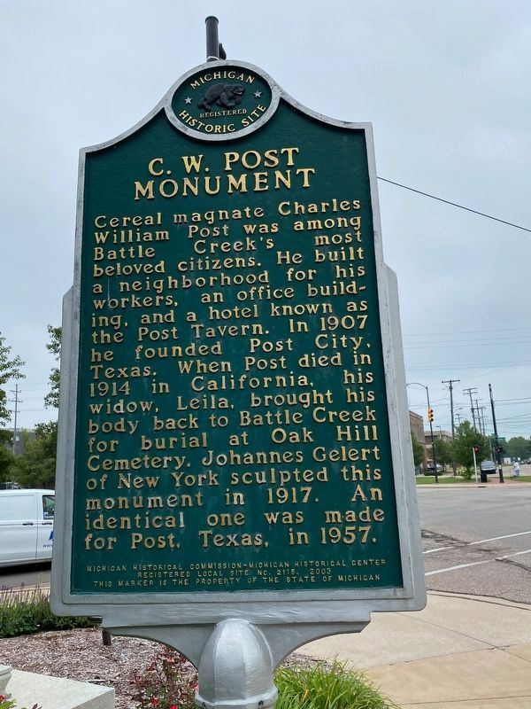
C. W. Post A native of Springfield, Illinois, Charles William Post came to this city in 1891 as a patient at the Battle Creek Sanitarium. In 1892 he opened his own sanitarium and dedicated himself to developing and manufacturing healthy food . . . — — Map (db m177336) HM
This is Battle Creek, where the leading producers of ready-to-eat cereals are located. Early attempts to process grains into appetizing new foods for Sanitarium guests revolutionized the eating habits of people everywhere. Made in Battle . . . — — Map (db m177263) HM
Erastus Hussey Stationmaster
Erastus Hussey came to Michigan from New York State in 1824 and purchased land in Wayne County. Hussey returned to New York for a time, but in 1839 he and his wife, Sarah, purchased a building located about 125 . . . — — Map (db m177310) HM
Postum Cereal Company Charles William “C. W.” Post (1854-1914) began his breakfast empire in 1892 when he opened La Vita Inn sanitarium on this site. Post’s first commercial success occurred in 1894 when he created the hot beverage Postum. In . . . — — Map (db m177342) HM
Ward Mill Site In 1845 Joseph M. Ward (1822-1902) joined William Fargo in a livery and freight business, located on the corner of State and Jefferson Streets. In 1849, Ward bought an interest in a woolen mill on the nearby creek, which he . . . — — Map (db m177321) HM
Chauncey M. Brewer immigrated
from upstate New York in 1836 at
the age of 21 years. He was elected
Marshall's first Treasurer in 1838 and
by occupation was a prosperous
dry goods merchant with associates
which included his sons, C.D. and . . . — — Map (db m190086) HM
Gorham (1812-1901) came to Marshall in 1836 from New York State. First a merchant, he became a banker and in 1865 organized the First National Bank of Marshall, now the Michigan National Bank. He was a defendant in the famous Crosswhite fugitive . . . — — Map (db m225807) HM
Gauss Ice House In 1883, J. Fred Gauss (1838-1902) bought an ice house 500 feet east of here. He harvested ice blocks from the Kalamazoo River’s mill pond, using sleds and horses to move them. In 1894, he added a steam-powered elevator to move . . . — — Map (db m177174) HM
Charles T. Gorham (1812-1901) came to Marshall with Chauncey Brewer and opened the Eagle Store in 1836. A native of Danbury, Connecticut, he opened Gorham's Exchange Bank in 1840. He was convicted for aiding escaped slave Adam Crosswhite and his . . . — — Map (db m190363) HM
This plaque is issued by the
Historical Society of Michigan
in recognition of
Hemmingsen Rexall Drug Store
Founded in 1855
for more than 100 years of
continuous operation in service
to the people of Michigan
and for contributing . . . — — Map (db m183894) HM
Horace Perrin Horace J. Perrin (1819-1880) was a prominent businessman and industrialist. Born in New York State, Perrin settled in Marshall in 1846 and founded a general store in the city’s growing downtown. An accomplished financier, he also . . . — — Map (db m177173) HM
The murals to the right, depict the history of
this Michigan Avenue business site.
The interurban depot was located here
from 1903 until 1929 at which time the
electric railway went out of business.
Richard C. Walters, Sr. purchased the
vacant . . . — — Map (db m216526) HM
Michigan's first congressman lived here from the early 1840s until his death in 1854. Located on lots one and two, original plat, lower village, the house was a wedding gift from his father-in-law, Judge Abner Pratt. Arriving here in 1831, Crary . . . — — Map (db m226057) HM
In 1831 Sidney and George Ketchum located here on Rice Creek. This first settlement in Marshall consisted of a water-powered sawmill and log cabins. Until the twentieth century this was an important industrial area, containing at various times a . . . — — Map (db m177154) HM
Named for Sidney (1797-1862) and George (1794-1853) Ketchum, the brothers who created Marshall. A land surveyor and developer, Sidney obtained the grants around Rice Creek to create and name Marshall. George, an engineer for the Ohio and Chesapeake . . . — — Map (db m177176) HM
In recognition of
Michigan National Bank Marshall Branch
Founded in 1865 For more than 100 years of
continuous operation in service
to the people of Michigan
and for contributing to the
economic growth and vitality
of our state. — — Map (db m216523) HM
Oliver C. Comstock Jr. (1806-1895) built this Gothic Revival house between 1849 and 1856. Comstock, born in Fairfield, New York, migrated to the Marshall area in 1836. He left a well-established medical practice in Trumansburg, New York, to start . . . — — Map (db m177178) HM
Operated Smithfield-Banques, Antiques & Curiosities on this site from 1990 to 2007
This plaque dedicated in loving memory
of
Opal A dear mother an friend
October 4th, 1912 - September 27th, 2008 — — Map (db m216485) HM
More than fifty medicine companies have operated out of Marshall. Thirty-seven of these emerged from 1895 to 1905, the heyday of over-the-counter remedies known as “patent medicines.” Before the Pure Food and Drug Act of 1906, some unregulated . . . — — Map (db m177242) HM
Samuel W. Hill (1819 - 1889) was the legendary surveyor and mining expert from Starksboro, Vermont who allegedly swore so badly that it was commonplace to use his name as in "What the Sam Hill" to replace swear words. Hill worked with Dr. Douglas . . . — — Map (db m189528) HM
Samuel W. Hill, legendary figure of the northland, surveyed the Great Lakes’ harbors in 1840-44 and worked with Dr. Douglass Houghton on the first geological survey of the Upper Peninsula in 1845. He was later involved with the sale of land and the . . . — — Map (db m177245) HM
German immigrant Jacob Schellenberger built this structure as both a home and tavern. A stone cutter by trade, Schellenberger obtained sandstone from along the nearby Kalamazoo River for the building which he completed around 1840. Because of its . . . — — Map (db m177180) HM
A hotel or inn has occupied this site since 1870. Here stood The Exchange which became the Johnson House in 1892. The Painter family erected the present brick building in 1895 then known as The Royal. Albert W. Schuler, Sr. purchased the hotel in . . . — — Map (db m177238) HM
Sidney Ketchum (1797-1862) Sidney Ketchum, a land surveyor, was born in Clinton County, New York. Seeking a new home and hoping to found a town, Ketchum explored central lower Michigan in 1830. Later that year he obtained government grants for . . . — — Map (db m177175) HM
In recognition of
Stage Coach Inn Founded in 1845 For more than 100 years of
continuous operation in service
to the people of Michigan
and for contributing to the
economic growth and vitality
of our state. — — Map (db m216533) HM
This plaque is issued by the
Historical Society of Michigan
in recognition of
Sullivan Insurance Agency, Inc.
Founded in 1853
for more than 100 years of
continuous operation in service
to the people of Michigan
and for . . . — — Map (db m183891) HM
Built by William Prindle in 1857, this landmark served as a livery stable for over sixty years. It also saw brief use as a stagecoach stop for the lines connecting Coldwater with Lansing. By 1928 it had become an unsightly gas station. Purchased . . . — — Map (db m177239) HM
The Stagecoach Inn is recognized as one of the outstanding examples in Michigan of the Greek Revival architecture in America. Built in 1838, it stands directly on the famous Territorial Road, following Indian trails from Detroit to Chicago.
Mr. . . . — — Map (db m216535) HM
In recognition of
The Stuart Building The Stuart Family has owned and
operated businesses on this site
for more than 130 years of
continuous operation in service
to the people of Michigan
and for contributing to the
economic growth and . . . — — Map (db m216524) HM
Frank A. Stuart and Harold C. Brooks ran successful medical businesses. Stuart’s company, founded around 1892, incorporated as the F. A. Stuart Company in 1898. Its most popular product was “Stuart’s Dyspepsia Tablets.” In 1880, Charles E. Brooks . . . — — Map (db m177240) HM
This Queen Anne house was built in 1898 for Tekonsha businessman Harvey N. Randall (1859-1917) and his wife, dressmaker Adell Warboys Randall (1863-1943). Randall prospered as a produce, livestock, and hardware merchant. By 1905 he established the . . . — — Map (db m223761) HM
On this site in January 1893, the Beckwith and Lee families opened and dedicated the Beckwith Memorial Building in honor of Philo D. Beckwith (1825-1889). P.D. Beckwith moved to Dowagiac in 1854 and became one of the most important individuals to . . . — — Map (db m217930) HM
Farr Park is named for Michigan native and Civil War veteran Willis M. Farr, born August 1, 1844, who was an industrialist and a Dowagiac city alderman in the 1880's. Mr. Farr was a partner in Dowagiac Manufacturing Co., a maker of grain drills. . . . — — Map (db m202749) HM
(Side A)
Big Rock Point
Big Rock Point is named for a large boulder used as a landmark by Native Americans. At least as early as the mid-nineteenth century Odawa (Ottawa) Indians used Big Rock, which they called Kitcheossening, as a . . . — — Map (db m97483) HM
Boyne's first regular storekeeper was Alfred J. Beardsley. He was born on a farm in St. Clair County in 1854 and in June 1875, journeyed to Boyne, where he opened a small dry goods store in the Pine Lake House.
In April of 1885, he . . . — — Map (db m230204) HM
Built in 1903 by C.I. Bellamy who came to Boyne from Luther, Mich. An up-to-date place of amusement, it was pronounced by experts as "the handsomest for its size in the state".
The theater opened in 1904 and featured a stage twenty-five feet . . . — — Map (db m230296) HM
When Bergy Bros. opened the doors of their new mercantile establishment, "The public came, saw a fine display of goods and bought liberally". Messrs. Bergy brothers were gentlemen of experience. Previous to coming to Boyne City, M.E. Bergy had . . . — — Map (db m216062) HM
"A popular gathering place for lovers of the weed" was established by C.E. Chase right after the turn of the century. The business was known throughout the City of Boyne.
Mr. Chase, proprietor of the well kept store, produced an excellent . . . — — Map (db m230203) HM
From 1890 to the present, Boyne City's commercial center has flanked the south bank of the Boyne River. The late Victorian facades of its earliest buildings were influenced by fashionable turn-of-the-twentieth century architecture. Buildings of . . . — — Map (db m230392) HM
Frank Kaden, one of Boyne's Pioneer merchants was born in 1862 and first came to this area in 1876 from Philadelphia. After operating a business in Boyne Falls for several years and spending some time in California, he returned to Boyne City and . . . — — Map (db m216128) HM
It is not certain when this building was erected, but it was most likely built around 1880. During the past century, it has served a wide variety of businesses. One of the most notable was "La Chapelle Sisters" Millinery Emporium which opened in . . . — — Map (db m216139) HM
This Railroad Office Building served as the Boyne City, Gaylord and Alpena Railroad general office during Boyne's lumbering era.
It is not known when the office building was constructed, but it was first located on the east side of Lake . . . — — Map (db m216179) HM
S. Dosie opened the finest store in Greater Boyne on March 20, 1907 where the stock featuring all the latest and correct styles, was arranged in Metropolitan style.
The two-story building was 25 by 94 feet and was, in every sense of the . . . — — Map (db m216065) HM
Clarence C. Schaub first worked in the meat business with his brother, J.C. Schaub, in 1894 at the corner of Lake and Main.
In 1900, Clarence sold his share of the business and headed west. Three years later he returned to Boyne City and . . . — — Map (db m230285) HM
Sometimes called the Riverside Hotel, the 24 room hotel opened to the public in 1904.
Charles O. Fry, proprietor, ran a comfortable hostlery, where guests were made to feel they had found a home, not just a stopping place.
At all times, . . . — — Map (db m230201) HM
Before the era of the drug store, most folks relied on the patent medicine industry to cure the grevous ills of mankind. A popular medicine of the day was Thedford's Black Drought which claimed to cure everything from bad blood to headaches.
. . . — — Map (db m216127) HM
On May 1, 1907, Frank Meyers became the proprietor of the newly remodeled hotel.
A weary traveler could register at the 52 room hotel for two dollars a day. The rooms were clean, light, airy and well furnished and the cuisine irreproachable . . . — — Map (db m216066) HM
The International Order of Odd Fellows built this grand hall in 1906. It was constructed by J.I. Gee and was Boyne's first poured concrete building. The walls are sixteen inches thick and reinforced with rock and railroad ties.
The I.O.O.F's . . . — — Map (db m216131) HM
It is the oldest business still operating under the same family management. The first business was operated by James B. Stackus, a Civil War veteran, who came to the Boyne area in 1875. A cabinet maker by trade he soon had a successful business. . . . — — Map (db m230288) HM
Not one, but two, United States Hotels once stood on this corner. The first, a fine three-story hotel, was built by Frank Abraham and George Beardsley and opened in 1878. In 1880, the U.S. Hotel burned and a new hotel was erected in its place. In . . . — — Map (db m215924) HM
This flagpole once stood at the site of Consumers Energy's Big Rock Point Nuclear Plant, about 4.5 miles northwest of Charlevoix off of U.S. 31. The plant set several industry records throughout its operating life from 1962 to 1997 and was named a . . . — — Map (db m98098) HM
The pie crust measured from 14 feet, 4 inches in diameter, 2 feet deep and weighing a total of 7 tons. A total of 1,730 lbs. for the pie crust 850 lbs. of flour 325 lbs. of water 15 lbs. of salt 110 lbs. of milk 375 lbs. of shortening 55 . . . — — Map (db m154653) HM
Fishing and Lumbering - Round Lake, North ShoreTug Loaded with Lake Trout
ca. 1900
When Charlevoix was permanently settled in 1854, Lake Michigan teemed with millions of tons of fish, called "finny . . . — — Map (db m215844) HM
Elm Pointe is an eleven-acre estate developed c. 1926 by John J. and Eva Porter. the house, designed by Grand Rapids architect J. Alexander McColl, was constructed of lumber milled by the East Jordan Lumber Company. An unusual, contemporary . . . — — Map (db m215776) HM
Established in 1876, this building has served as a store and post office and as the village's center of business and social life. Hemingway frequented it both as a boy and as a young man. He described its "high false front" in his story "Up in . . . — — Map (db m98008) HM
Jim and Elizabeth Dilworth operated Pinehurst, an inn providing meals and tourist lodging. The Hemingways were family friends and Ernest often stayed here. His wedding reception was held here in 1921 and next door at Shangri-la, a rooming house . . . — — Map (db m98030) HM
Named for pioneer settler Samuel Horton, this village was founded as a lumbering community in 1876, complete with sawmill, shanty boys, boarding house, company store, blacksmith shop, and draft horses. The store and many early buildings still . . . — — Map (db m98027) HM
Norwood was settled in 1866 when Orvis Wood, Lucius Pearl, and Orwin Adams built a dock and sawmill on the shore of Lake Michigan. The town thrived as a lumber shipping center with sawmills, a company store, and blacksmith shops. In 1884 the Norwood . . . — — Map (db m98099) HM
Great Lakes shipping is a key component to the regional economy. The shipping industry is one of the cheapest and most efficient ways to transport large quantities of raw materials, such as iron ore, coal and heating oil. Extending the shipping . . . — — Map (db m138486) HM
John Askin arrived in America in 1758 at the age of 20. Upon arrival, he joined the British army and was stationed at Albany, in the New York colony. There he began a lucrative trading business in the Great Lakes region. Askin arrived at Fort . . . — — Map (db m135161) HM
Boats delivered products from all over the world to Michilimackinac during the 1700s. After long, arduous journeys they often needed to be repaired here.
Based on artifacts found at this site, such as 1770s sailmaker's needles, and the . . . — — Map (db m138441) HM
Fishing became the subsistence occupation in Mackinaw when the fur trading industry collapsed in the 1840s. It has continued to be a major employer for over 170 years.
The first large fishery on this site was built in 1892 and was owned . . . — — Map (db m138430) HM
Long lines, fresh pasties and good company while waiting to cross the Straits
Once the state ferry service became established, it became easier (and cheaper) to get a vehicle across the Straits of Mackinac. Many tourists have fond memories . . . — — Map (db m214021) HM
Founder of Mackinaw City Presented at the dedication of the statue of Edgar Conkling by Jerry Prior in Conkling Heritage Park
Edgar was born in New York during the War of 1812, while Mackinaw City was still a British territory. He was raised . . . — — Map (db m131698) HM
Harvested in Mackinaw, shipped around the Great Lakes, the ice was used to cool food and people.
Selling ice for refrigeration to the fish houses, railroads, and homes was big business from the late 1800s to World War II, and Mackinaw . . . — — Map (db m138336) HM
The strategic importance of the Great Lakes during the fur trade made Michilimackinac a well-known name throughout the world by all the superpowers of the time. Before trains and cars were invented, people of the Great Lakes traveled on the . . . — — Map (db m140741) HM
The Mackinaw Boat was designed for northern Great Lakes conditions
The Mackinaw boat was the work boat of fur traders, fishermen, settlers and lake travelers for hundreds of years, from the early 1700s to the early 1900s.
The hull . . . — — Map (db m140770) HM
Mackinaw City Railroad Dock
Before the Mackinac Bridge opened in 1957, ships were the only means of connecting Michigan's peninsulas. During the 1870s, small sailing vessels served as ferries. Steamboats took over when the Michigan Central . . . — — Map (db m131700) HM
In the early 1880s the main street of Mackinaw City consisted of these first two blocks of North Huron Avenue. Within only 40 years, in 1900 and again in 1916, two devastating fires completely destroyed the original business district. . . . — — Map (db m140723) HM
When Patrick Sinclair moved Fort Michilimackinac from the mainland to Mackinac Island in 1780, he recognized the need for a saw mill to provide lumber for the new fort and adjoining community buildings. Sinclair granted private claim 334, . . . — — Map (db m138192) HM
In 1780 the British garrison at Fort Michilimackinac moved to Mackinac Island as a safer location during the American Revolution. Robert Campbell built a sawmill on this site to furnish lumber for the new fort and settlement. His sawmill and dam . . . — — Map (db m59978) HM
Perry Darrow was a special person in our community; wherever he went, he had a smile and willing hands to help anyone.
He was born in Kniffenville, a small settlement of Mackinaw City near Drydock Lake. His parents, Glen (Slim) and Bea . . . — — Map (db m140106) HM
Mackinaw's economy was originally built on the fur trade. When that faltered in the 1840s it was supplanted by fising, lumbering, and today's tourism.
The summer of 1871 was hot, dry, and windy, resulting in devastating fires across the . . . — — Map (db m140869) HM
Before the railroads were extended to Mackinaw City in 1881, the Straits area remained isolated and its activities were limited to commercial pursuits such as lumbering and serving the expanding shipping industry. Once land routes were cut . . . — — Map (db m135209) HM
Built in 1951 by R. Dale & Patricia Barnett
This was originally the Barnett Insurance Agency and The Santa Claus Shop with a living area in the back. In 1972, the living area became Antique Alley. Now a rental property, it is still owned by . . . — — Map (db m232255) HM
In 1881, John M. Sanborn surveyed land owned Daniel McKillop and platted the village of Torrey. That year a post office opened here under the name "Wolverine." In 1882 the village was replatted as Wolverine. By the turn of the century, lumbering . . . — — Map (db m138106) HM
In the northern Lower Peninsula, the first railroads were built to move lumber from station to mill and from mill to cities. Later, their main business became moving passengers from one town to another. Many northern counties quadrupled their . . . — — Map (db m138120) HM
This point of land is the historic battleground where the westward invasion by the Iroquois Indians was halted by the victorious Chippewa.
Off the point colorful French-Canadian voyageurs paddled canoes heavily laden with furs. The 18th century . . . — — Map (db m4452) HM
Once a thriving hub of pine lumbering, Emerson is now a fishing hamlet. Just one mile south of the mouth of the Tahquamenon River (immortalized in Longfellows poem “Hiawatha”), this settlement overlooks picturesque Whitefish Bay. The village was . . . — — Map (db m213408) HM
In 1849 the Whitefish Point lighthouse was put into service. Soon after the township was organized in 1888, lumber towns such as Emerson and Shelldrake emerged at the mouth of the Tahquamenon and Shelldrake rivers. Paradise was established in . . . — — Map (db m214012) HM
By the mid-1830s, there were at least two hotels on Water Street. One, known for a time as the Van Anden House and later as the Chippewa House, was on the southeast corner of Water and present day Ashmun streets. The other eventually became the . . . — — Map (db m214154) HM
In 1845, the Independence became the first steam vessel on Lake Superior.
Arriving below the falls in 1845, the 105 foot long vessel was hauled out of the water and portaged nearly a mile around the falls and re-launched above the rapids.
The . . . — — Map (db m214167) HM
When American troops arrived in 1822 to establish a
fort, the soldiers built a mill race, which ran from above
the rapids to a mill located near the present Osborn-
Portage intersection, with the water returning to the river
at approximately . . . — — Map (db m214165) HM
Former home and trading post
of the
John Johnston Family
second oldest building in the northwest
built in 1795 - 96
Here in 1824,
Henry Rowe Schoolcraft, historian
married Jane,
daughter of Johnston
and his O'Jibway Indian . . . — — Map (db m213416) HM
Walk along Water Street and you will cross the stage where many of the events of Sault Ste. Marie's early history played out.
Our interpretive panels along the way will help you understand the important role the St. Marys River played in our . . . — — Map (db m214853) HM
On this site in 1822-23 a water power Saw Mill the first power manufacturing plant in the north country was built by Fort Brady personnel — — Map (db m214166) HM
By the late 1880s, business was booming on Water Street. Railroad lines had come, a water power plant had been constructed at the rapids, and a second lock had been built. Sault Ste. Marie was incorporated as a city in 1887.
After a fire . . . — — Map (db m214159) HM
In 1971, in a small garage on 7th Street in Clare, Jay and Arlene Poet saw a dream begin: Jay's Sporting Goods store was born. With more optimism than resources, they started a business that would take advantage of Jay's extensive knowledge of and . . . — — Map (db m190693) HM
In 1860 State Geologist Alexander Winchell reported that oil and gas deposits lay under Michigan's surface. First commercial production was at Port Huron where 22 wells were drilled, beginning in 1886. Total output was small. Michigan's first oil . . . — — Map (db m136472) HM
Dr. Richard Simmons had
this one and a half story
frame house built in the late
1890's. It featured detailed
oak woodwork on the
interior. Dr. Simmons'
office was located in the
building now housing the
Family Barber shop. — — Map (db m233937) HM
Built in the early 1850s, this
saltbox home was originally
located at 206 W. Main. Dr.
George Topping purchased it in
1856 and used it as an office and
drugstore. It was moved to its
present location about 1913. — — Map (db m233936) HM
In 1996, the Ovid Historical Society with the financial aid of the Downtown Development Association purchased a carriage that had been manufactured at the Ovid Carriage Works, later known as the Scofield Buggy Company in Ovid. The members of the . . . — — Map (db m119805) HM
Built in 1869-70 for George D. and Carrie Sowers, this house is an excellent example of Italianate architecture. Sowers, the first of several prominent local businessmen to live here, owned a planing mill located across the street with his partner, . . . — — Map (db m119389) HM
Village of Ovid
In 1836, inhabitants of Ovid, Seneca Falls County, New York, began to settle this fertile farm area. Among them were Samuel Barker, who built his log cabin in "Section 6;" Jabez Denison, noted for his prowess in killing . . . — — Map (db m119352) HM
Anthony (2002-2016) was the youngest of 11 children and
his family restored many Ovid buildings. He spoke
Spanish, made 6 missionary trips to Central America and was
the joyful greeter at Henry and Ida's Gospel Barn in Ovid.
Building occupants . . . — — Map (db m216355) HM
Home to the horse-drawn carriage industry, a video store,
church, tavern, recreation center, hardware store, dancehall
and medical office where Emily Kelley (1988-2013)
was the first infant patient.
In her lifetime Emily helped restore 4 Ovid . . . — — Map (db m216356) HM
1208 entries matched your criteria. Entries 101 through 200 are listed above. ⊲ Previous 100 — Next 100 ⊳