Near North Mississippi Avenue (U.S. 69) 0.8 miles north of West Liberty Road (U.S. 75), on the right when traveling north.
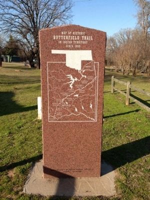
On September 16, 1857, the John Butterfield Company received a Federal contract to transport mail from Missouri to San Francisco in under 25 days. Semiweekly service began a year later. Twelve relay stations lined the Butterfield Trail in Indian . . . — — Map (db m64072) HM
On County Highway 1230 at County Highway 2000, on the left when traveling west on County Highway 1230.
In honor of the people who lived here from 1892 to 1957, and built this community.
Life in the community, which at one time included 2 general stores, a barber shop, blacksmith shop, grain grinding mills, church and family residences, centered . . . — — Map (db m209528) HM
On West 2nd Street, on the right when traveling west.
More than 6 million cattle went up this trail from Texas to Kansas between 1874 and 1888.
The trail crossed this area approximately 10 miles east of this location. — — Map (db m162452) HM
On West 3rd Street (Business Interstate 40) west of Pioneer Road, on the right when traveling west.
Established in 1998, the National Route 66 and Old Town Museum Complex preserves the history of Route 66 in Western Oklahoma.
Recognized by Hampton Hotels Save-A-Landmark program as a site worth seeing — — Map (db m183510) HM
On U.S. 66 near North Pioneer Road, on the left when traveling east.
The deep Anadarko Basin of Western Oklahoma is one of the most prolific gas provinces of North America. Wells drilled here have been among the world's deepest. The Bertha-Rogers No. 1 in Washita County, drilled in 1971 to 31,441 feet, was then . . . — — Map (db m162463) HM
On South Sheb Wooley Street south of West 3rd Street, on the right when traveling south.
Formerly the City Meat Market, this is known as the oldest brick building in Erick. It is now the home of Harley and Annabelle, "The Mediocre Music Makers."
Recognized by Hampton Hotels Save-A-Landmark program as a site worth . . . — — Map (db m183509) HM
On Buffalo Street (State Highway 22) west of Main Street, on the right when traveling east.
Ben Siegel at age 14 came to America from Lithuania. He established a business in Caddo, Indian Territory in 1895. One of Bryan County's first merchants, he was an important part of the early trade area. — — Map (db m73423) HM
On Buffalo Street (State Highway 22) west of Main Street, on the right when traveling east.
In 1955 the Craighead family purchased this store which for over four decades has served and intrigued children as well as adults:
Partial records show previous owners as:
E. F. Nichols - original site - 1905
Boone Styron Dry Goods - . . . — — Map (db m73424) HM
On Buffalo Street (State Highway 22) at Main Street, on the right when traveling east on Buffalo Street.
John S. Hancock and his young son Clement Allen Hancock followed the MKT Railroad to Caddo in 1872. They established a business at this location and became two of Caddo's founding businessmen and community leaders. — — Map (db m73410) HM
On West Broadway Street at South 1st Street, on the left when traveling west on West Broadway Street.
Martinez 1911 is embossed atop the store front. Andres Martinez, known as Andele, was an Apache captive. One day he and his nephew were taken by a band of Mescalaro Apache Indians. Andele's nephew, Pedro, didn't survive. Andele remained a slave for . . . — — Map (db m181819) HM
On Old U.S. 66 east of South Coleman Avenue, on the right when traveling east.
This rural Rt. 66 filling station with an over the drive design was built by Carl Ditmore in 1929.
W.O. Waldrop bought the business/home in 1934 and renamed the place, the Provine Station. A small tourist court was added for overnight stays. . . . — — Map (db m174530) HM
The Fort Reno Commissary is a 234-foot-long, 16,300 square foot building. It was constructed in three parts. The center section was built in 1885. The north and south sections were added in 1886. Supply trains and freight wagons brought food and . . . — — Map (db m171125) HM
On South Evans Avenue south of West Watts Street, on the left when traveling north.
The home was built in 1900-1901, by William and Magdalen Goff. Mr. Goff came to El Reno, in 1892, to work for Anheuser and Busch. He soon became an agent for the firm, later he started Goff Bottling Works and organized the Goff Cadet Band.
The . . . — — Map (db m171134) HM
On West Broadway Street at B Street NW, on the right when traveling west on West Broadway Street.
This building, originally built in 1930 by
architect J.B. White, was called the
Gilbert Building. It was renamed the
Ardmoreite Building in 1966 when it
became the home of The Daily
Ardmoreite. Between 1930 and 1966
many businesses . . . — — Map (db m142416) HM
On East Main Street at Mill Street NE, on the left when traveling east on East Main Street.
Daubes’ Department Store was a long time landmark on Main Street of Ardmore.
The original Daube Store was opened in Bowie, Texas, in 1883, and was owned by Sam Daube.
In about 1888, when the Ardmore area was in Pickens County, Indian . . . — — Map (db m142482) HM
On North Washington Street at Paradise Alley, on the left when traveling north on North Washington Street.
The Hotel Wisnor, named in honor of Benjamin Wisnor Carter, prominent Chickasaw citizen, was built on this site in 1884 and was the first and finest establishment of its kind in Indian Territory. The three-story building of brick and stone had 50 . . . — — Map (db m142485) HM
On West Main Street (Oklahoma Route 199) west of B Street SW, on the left when traveling west.
In 1893, E.B. Luke came to Ardmore, Chickasaw Nation, from Detroit, Michigan. At the time, his brother, Jack Luke, operated a music and school book store in Oklahoma City, and urged E.B. to open this same type of store in Ardmore. So in 1895, E.B. . . . — — Map (db m142420) HM
On West Main Street (Oklahoma Route 199) at B Street SW, on the left when traveling west on West Main Street.
The Noble Brothers, Sam and Ed, arrived in Ardmore, Chickasaw Nation, in 1893, from Oakland Prairie, Pickens County, after a brief sojourn in Pottsboro, Texas, where they were partners in a general merchandise business and operated a ferry crossing . . . — — Map (db m142481) HM
On West Main Street (Oklahoma Route 199) west of B Street NW, on the right when traveling west.
Before 1899, J.W. Banks built, at this site, a mercantile establishment combined with lodging quarters. In 1903, W.F. (Dixie) Gilmer arrived from North Carolina and leased the hotel which was a three story structure with rooms on the second and . . . — — Map (db m142422) HM
On East Main Street west of SE 5th Street, on the right when traveling west.
Production of crude oil from the newly-discovered Healdton field surrounding this marker site flooded the marker with an oversupply of petroleum protesting that pipeline purchases were inadequate. Producers claimed they were being deprived of . . . — — Map (db m180600) HM
Near Red Road, 0.8 miles north of Tram Road, on the right when traveling north.
Archaeologists found the partial remains of two different buildings when this site was excavated in 1995 and 1996. All that remained of one building was a section of stone foundation. The construction of this wall showed that it was the northwest . . . — — Map (db m238985) HM
Near Red Road, 0.8 miles north of Tram Road, on the right when traveling north.
Archaeologists spent the summers of 1995, 1996, and 1997 digging to unravel the mysteries of this area. All that was visible before they began was a small, low, earth mound with a few protruding rocks and brick fragments. The archaeologists . . . — — Map (db m238283) HM
Near North 4355 Road, 0.7 miles north of U.S. 70, on the left when traveling north.
The post's sutler was a civilian storekeeper permitted by the Federal government to operate a trading house on or near a fort. His general merchandise business provided goods and services not regularly supplied by the military. It was also open to . . . — — Map (db m239504) HM
On 325, 3.6 miles north of E0190 Road, on the left when traveling north.
(left panel) A Bridge Between the United States and Mexico
Before you is a portion of the historic Santa Fe Trail. Established as a wagon route by William Becknell in 1822, the Santa Fe Trail became the first major trade link between . . . — — Map (db m131308) HM
"The Queen of the Frisco Railroad rolled into Lawton, Oklahoma on Friday, July 7, 1961 on her last journey."
Baldwin Locomotive Works in Philadelphia, Pennsylvania is one of the most successful builders of locomotives in the world. The . . . — — Map (db m204481) HM
On West Missouri Avenue (Oklahoma Route 5) west of North 9th Street, on the right when traveling east.
At the opening of Kiowa-Comanche-Apache lands, the original townsite in old Comanche County was SW 1/4, T2S, R11W. The original name McKnight was rejected by the post office. The name Walter, for City Commissioner W.R. Walter, was then chosen Sept. . . . — — Map (db m119434) HM
On East Broadway Street (Oklahoma Route 33) east of North Harley Avenue, on the right when traveling west.
Site of the No. 1 F.M. Wheeler, discovery well of the Drumright-Cushing Oilfield. It's completion by C.B. Shaffer, et al, on April 1, 1912, set off one of the greatest "oil booms" in history. The well produced oil for more than 35 years. — — Map (db m213818) HM
Near West Gary Boulevard (Business Interstate 40) south of West Modelle Avenue (U.S. 73).
The Calmez Hotel opened on Thanksgiving Day, November 28, 1929, in Clinton, Oklahoma. Featuring 130 rooms equipped with private power line, the Calmez was western Oklahoma's finest hotel. The large, bright sign on top of the building that read . . . — — Map (db m188055) HM
Near West Gary Boulevard (Business Interstate 40) south of West Modelle Avenue (State Highway 73).
The Clinton Drive-In opened on August 17, 1949. The drive-in was located three miles south on Route 66 next to Neptune Park. Featuring two shows nightly and individual speakers for the 300 spaces, admission was forty cents for adults and ten cents . . . — — Map (db m188059) HM
Near West Gary Boulevard (Business Interstate 40) south of West Modelle Avenue (State Highway 73).
The Glancy Motor Hotel was built in 1939 by Chester and Gladys Glancy.
Located next door to Pop Hicks' Restaurant, the hotel quickly became an icon of Route 66. Best known for its iconic neon sign, the motel is still in operation today. — — Map (db m188053) HM
Near West Gary Boulevard (Business Interstate 40) south of West Modelle Avenue (State Highway 73).
The Marshall Café opened its doors in 1953. Owned by George Marshall, the café was best known for steak and chicken dinners. The restaurant was located on the 10th street alignment of Route 66 (Route 66 followed 10th street from 1926 to 1958) and . . . — — Map (db m188052) HM
Near West Gary Boulevard (Business Interstate 40) south of West Modelle Avenue (State Highway 73).
The Mohawk Lodge Indian Store first opened in 1892 in Colony, Oklahoma Territory. Intended to provide local Native Americans an outlet for handmade items, the store was sponsored by the Dutch Reform Church of New York.
The store moved to . . . — — Map (db m188056) HM
Near West Gary Boulevard (Business Interstate 40) south of West Modelle Avenue (State Highway 73).
Ethan Edwin "Pop" Hicks opened his restaurant on New Year's Day in 1936. The original café had three small booths and four barstools. Over the years, Hicks made many additions to the café, including a banquet room - the first of its kind in the . . . — — Map (db m188051) HM
Near West Gary Boulevard (Business Interstate 40) south of West Modelle Avenue (State Highway 73).
The Rialto Theater opened in 1922. It hosted live theater, talent shows, cooking demonstrations and featured a large screen for panoramic movies. In 1950, the theater was remodeled and had its name changed to Redland Theater. Although no longer a . . . — — Map (db m188057) HM
Near West Gary Boulevard (Business Interstate 40) south of West Modelle Avenue (State Highway 73).
Originally known as the Rio Courts, the Rio Siesta Motel was expanded and the name changed in the early 1960's. The hotel was best known for its large neon sign. To attract customers from the busy road, the tall sign included a man in a sombrero . . . — — Map (db m188058) HM
On West Gary Boulevard (Business Interstate 40) west of South Modelle Avenue, on the right when traveling west.
The Valentine Manufacturing Company in Wichita, Kansas built Valentine Diners between 1938 and 1974. They were the only significant diner manufacturer outside the Northeast. The Valentine Diner was a small, boxy diner, which was radically different . . . — — Map (db m171153) HM
Near West Gary Boulevard (Business Interstate 40) south of West Modelle Avenue (State Highway 73).
You have come to the right place! The Oklahoma Route 66 Museum opened in 1995. It is the largest history museum dedicated to the history and culture of Route 66. Travel through the decades and see the people involved with the creation of the Mother . . . — — Map (db m188060) HM
Near West Gary Boulevard (Business Interstate 40) south of West Modelle Avenue (State Highway 73).
Constructed in 1937, the Y Service Station was strategically located in the middle of the Route 66 and Route 183 intersection on the southern edge of Clinton, Oklahoma. The Y Service Station offered food, fuel, auto repair and lodging to travelers. . . . — — Map (db m188049) HM
Near Gott Road, 0.7 miles south of West Southgate Road, on the right when traveling south.
A section of the famed Chisholm Trail (1867-1885), which was used to drive cattle from Texas to the rail heads in Kansas after the Civil War, crosses a portion of Vance AFB near the entrance to the Armed Forces Reserve Center. The trail was named . . . — — Map (db m89793) HM
On U.S. 64 at County Highway N2010, on the right when traveling east on U.S. 64.
The east-west section line one mile south of this marker was formerly Locust Street, in Charleston, Okea. The first post office was established June 18, 1901. Approximately one and one half mile south and one half mile west of here near the center . . . — — Map (db m181525) HM
On State Highway 9 at Tamaha Road, on the right when traveling west on State Highway 9.
One of the earliest port towns and trading centers in Choctaw Nation, I.T. Choctaws brought from Mississippi up Arkansas River to Tamaha on steamboats as early as 1831. Tamaha developed as port and ferry crossing around 1836. Post office built 1884 . . . — — Map (db m76457) HM
On Grant Street west of Main Street, on the right when traveling west.
Memorial to one of the earliest port towns and trading centers in the Choctaw Nation, I.T. Choctaws brought from Mississippi up Arkansas River to Tamaha on steamboats as early as 1831. Tamaha developed as port and ferry crossing around 1836. Post . . . — — Map (db m77875) HM
On State Highway 48, 0.3 miles south of Old Highway 12 (County Route D138), on the right when traveling south.
Est., 1834, by Lieut. T.H. Holmes, later Lt. Gen., C.S.A. This post was visited~June, 1834~by Gen. Henry Leavenworth on his expedition to the Plains tribes. Edwards' Store, site 1 mile west of here, was the last trading post until Santa Fe on the . . . — — Map (db m64074) HM
On County Road 1910, 1 mile east of U.S. 81, on the left when traveling east.
In recognition of heroism involving voluntary risk of life as firefighters with the 82d Civil Engineering Squadron, Sheppard Air Force Base, Texas, on 11 June 1995. Mr. Richard A. Hogan and A1C Christopher M. Rezac with complete disregard for . . . — — Map (db m142274) HM
On County Road 1910, 2.5 miles east of U.S. 81, on the right when traveling east.
Chisholm Trail Lookout Point
This site was given by Henry and Blanche Price in honor of the Pickens County Cowpunchers Association and all other cowboys and pioneers that used this trail
Replaced March 2007 Oklahoma Centennial . . . — — Map (db m142229) HM
On South Main Street (U.S. 177) south of East Padon Avenue, on the right when traveling south.
In honor of the employees of
Blackwell Zinc Company, Inc.
who served our country during World War II
and in memory of those
who made the supreme sacrifice
Keith M. Abshire
Rex U. Abshire
Clyde H. Adams
Charles E. . . . — — Map (db m223515) WM
On Broadway Avenue (U.S. 177) south of Main Street, on the right when traveling south.
Front
Braman
When the Santa Fe Railroad was extended from Hunnewell, Kansas to Tonkawa, a railroad promoter named J.W. Whistler chose the midway point as a good location for a town. With B.J. Templeton he bought the . . . — — Map (db m96590) HM
On Main Street (U.S. 77) at 7th Street, on the left when traveling north on Main Street.
This Roman Classic structure with a corner recessed entry and simple columns was built in 1899. The building was originally known as the Dilday building and is constructed with native limestone secured a few miles east of Newkirk. John Pierce . . . — — Map (db m60456) HM
On Main Street (U.S. 77) south of 7th Street, on the right when traveling north.
Dick Sherbon of Ponca City received the bid to erect this building for the Kay County Abstract Company in 1926. The bids for the building ranged from $4,400 to $5,700.
This red brick structure was limited to one story because of the . . . — — Map (db m60479) HM
On Main Street (U.S. 77) north of 7th Street, on the left when traveling north.
William S. Cline had this building constructed in 1925. This was the same year that the Kay County Courthouse and the Masonic Temple were constructed in Newkirk. The Cline Building is illustrative of the influence of the Art Deco style. . . . — — Map (db m60478) HM
On Ranch Road (State Highway 156) 0.5 miles south of White Eagle Road, on the right when traveling south.
Although nothing remains but the ruins of its foundation, the Miller family Mansion once stood here. Constructed in 1909 after the first stately wood frame home of Col. G.W. Miller, wife Molly, sons Joe, George, Zach and daughter Alma, burned in . . . — — Map (db m188215) HM
On Ranch Road (State Highway 156) 0.5 miles south of White Eagle Road, on the right when traveling south.
Named for its cattle brand '101,' this ranch was begun by Col. Geo. W. Miller on his claim at opening of Cherokee Strip, Sept. 16, 1893. Operated by sons, George, Joe and Zach Miller, the ranch covered 100,000 a. by 1926, world famous for its "White . . . — — Map (db m188167) HM
On Ranch Road (State Highway 156) 0.5 miles south of White Eagle Road, on the right when traveling south.
It is very likely that without the involvement and cooperation of various local and national Indian tribes, the 101 Ranch operating from 1893 to 1936, with headquarters at this location, could have been as successful as it once was.
Having been . . . — — Map (db m188168) HM
On State Highway 33 at U.S. 81, on the right when traveling west on State Highway 33.
This trade route from southern Texas to Kansas was used to drive an estimated five million head of cattle north to the raiheads in Abilene, Kansas from 1867 to 1884.
Named for a man of Scottish-Cherokee descent who built several trading posts . . . — — Map (db m185870) HM
On Emerald Vista Road north of Talimena National Scenic Byway. (Scenic Highway 1), on the right when traveling north.
Look for Stapp, Oklahoma beside Highway 270 in the valley below. The Buschow Lumber Company operated a mill and railroad here during the early 1900s. At that time the timber industry was primarily nomadic and the average life of a mill was 20 . . . — — Map (db m196082) HM
On Manvel Avenue (State Highway 66) at East 7th Street, on the right when traveling south on Manvel Avenue.
The Chandler Phillips 66 station is typical of the type "B" cottage-style built by Philips Petroleum 1927 through 1938.
Recognized by Hampton Hotels Save-a-Landmark program as a site worth seeing — — Map (db m189193) HM
On Marvel Avenue (State Highway 18/66) at 9th Street, on the left when traveling south on Marvel Avenue.
Built 1910 - 1911
Mayors J. A. McLaughlin,
H. C. McGoughy and A. B. Oleson
Street Commissioners: H. C. Tuttle 1910,
and D. D. Landsaw 1911
Dedicated Historical Site
October 1978 — — Map (db m41780) HM
On Broadway near 3rd Street, on the right when traveling south.
Paved in 1925 with bricks
manufactured at the
Davenport Brick & Tile Corp.
Financed with Paving District Bonds
Davenport Brick Plant in Operation
1911 - 1929 — — Map (db m41779) HM
On South 2nd Street south of West Oklahoma Avenue, on the right when traveling south.
The 1890 City Directory lists 107 S. 2nd as F. C. Bonfils Real Estate with residence on 2nd floor. Son of a Missouri Judge and descendant of Napoleon, he was 28 when he joined the Land Run of 1889. A colorful con man and lottery promoter, he had but . . . — — Map (db m141691) HM
On East Oklahoma Avenue east of North Division Street, on the left when traveling east.
Two buildings designed to look as one, the De Steiguer
building was an ornament of East Guthrie. Built in 1890 by
the banking pioneer De Steiguer brothers, Rodolph and Louis.
it housed their Bank of Guthrie in the west section, and a
tobacco . . . — — Map (db m141470) HM
On West Harrison Avenue west of South Division Street (U.S. 77), on the right when traveling west.
Restored in 1980 to its original look, the Foucart Building was built in 1891 by Edward T. Patten to house the Boston Store (dry goods) managed by J.M. Brooks, later builder of Brooks Opera House. Geo. King's New York Racket Store (notions, general) . . . — — Map (db m141933) HM
Wm. H. "Harry" Gray, a naturalized Canadian, homesteaded the lot bearing the west half of this building. He staked it April 22, 1889 and immediately relocated his grocery and wholesale business from Udall, Kan. His brother, George, joined him in . . . — — Map (db m141476) HM
On East Columbia at North Division Street, on the left when traveling east on East Columbia.
After successful settlement of rival claim to the lots by one Xenophon Fitzgerald, the Logan County Investment Co. built this imposing structure in 1901, financed by St. Louis, Missouri investors who foresaw a solid future for the town and . . . — — Map (db m141478) HM
On Adair Street at NE 1st Street, on the right when traveling north on Adair Street.
Pryor Creek was named in honor of Nathaniel Hale Pryor. Captain Pryor was a member of the Lewis and Clark Expedition, a veteran of the war of 1812 and was a Captain at the Battle of New Orleans, January 8, 1815. In June he was honorably discharged . . . — — Map (db m68099) HM
On State Highway 59 at U.S. 77, on the right when traveling west on State Highway 59.
Caravans of gold seekers in the Rush for California traveled this Trail in spring, 1849, under military escort commanded by Capt. R.B. Marcy. Route lay west from Ft. Smith, south side of Arkansas and Canadian rivers, across Oklahoma. Camp ground . . . — — Map (db m144810) HM
On U.S. 70 east of Oklahoma Highway N4450, on the left when traveling west.
Water powered grist mill in operation on Clear Creek early as 1819 by white settlers in old Miller County, Arkansas Territory. New mill built in 1837 by Choctaw Joel Kemp. A later owner, Choctaw John Wilson, replaced crude undershot wheel with . . . — — Map (db m24401) HM
On North 2nd Street near West Main Street, on the right when traveling north.
Established 1904 Indian Territory Richard Bawden Hutchins Proprietor Funeral Director & Embalmer Minnie Laura Cox Hutchins Wife & mother of seven Thamazin, Gladys, Alfred, George, Joe, Dorothy & R.B. First licensed lady embalmer in the state of . . . — — Map (db m207506) HM
On East Ash Avenue just east of Lee Street, on the left when traveling east.
The first commercial long distance telephone line in Oklahoma was placed in service here in 1886. It connected Fort Gibson with Tahlequah and Muskogee. The line was built by a company formed by a group of Cherokees, namely L.B. Bell, J.S. Stapler, . . . — — Map (db m136566) HM
On U.S. 64, 0.7 miles south of Skelly Road (County Route E0830), on the left when traveling south.
First peace council and alliance in Oklahoma between a European nation and Indian tribes held here at a Tawakoni village by Comdt Bernard De La Harpe on his first visit to the Arkansas River. He erected a post here carved with the coat-of-arms of . . . — — Map (db m77867) HM
On 32nd Street (U.S. 54/69) 0.2 miles north of Hancock Street, on the right when traveling north.
Muskogee Oil Refining Company, organized in March 1905, built a finishing plant near this site in November, 1904. It soon was producing lamp kerosene, lubricating oil and industrial fuel - the beginning of oil refining in Oklahoma, a leading . . . — — Map (db m73123) HM
On Main Street (State Highway 156) 0.2 miles north of West 8th Street, on the right when traveling south.
Named for its cattle brand "101", this ranch was begun by Col. Geo. W. Miller on his claim at the opening of the Cherokee Strip, Sept. 16, 1893. Operated by sons George, Joe and Zach Miller, the ranch covered 100,000 a. by 1926, world famous for its . . . — — Map (db m181522) HM
On State Highway 28 south of County Highway E0270, on the right when traveling south.
J.E. Campbell of Winchester, Virginia and his wife, Emma Journeycake Campbell, established a home (1000 feet West) and a store (500 feet West) in January, 1878. Through Mr. Campbell's influence the name, Lightning Creek Post-Office, was changed by . . . — — Map (db m170309) HM
On East Danforth Road (State Highway 66) 0.4 miles west of North Choctaw Road, on the right when traveling west.
This is one of the last old gasoline filling stations still standing in this part of the country. No one knows, for sure but was thought to have been built in the late teens, or early twenties. It had two pumps, one for regular gas and one for . . . — — Map (db m176319) HM
On West 1st Street east of South Santa Fe Drive, on the right when traveling east.
This was the first elevator and mill erected in Oklahoma. It was built by J.H. Snyder in 1891. Capacity was 30,000 bushels Mr. Snyder continued the business until his death in 1895.
In 1921 the firm went broke. A group of farmers formed a . . . — — Map (db m171177) HM
On East 2nd Street (U.S. 77) west of Meline Drive, on the right when traveling east.
James and Kathrine Kunc and son, William, made the run and homesteaded this quarter section April 22, 1889. That pioneer family continuously occupied the farm until William's son, Stanley Kunc, sold the land in 1982 for commercial development. . . . — — Map (db m170505) HM
On Northwest 39th Street (State Highway 66) west of North Tulsa Avenue, on the right when traveling east. Reported permanently removed.
Built in 1948 as a gas station, this site was converted into a restaurant in 1966 and became Ann's Chicken Fry House in 1971. It is famous for its chicken-fried steak.
Recognized by Hampton Hotels Save-a-Landmark program as a site worth . . . — — Map (db m189195) HM
On Northwest 4th Street at North Broadway Avenue, on the right when traveling east on Northwest 4th Street.
By 1920 the number of automobile dealers in Oklahoma City had grown to 76; 52 of those were located on Broadway between North 4th Street and 10th Street, a section became known as Automobile Alley. — — Map (db m175236) HM
On Northwest 5th Street at North Broadway Avenue, on the right when traveling east on Northwest 5th Street.
The V-8 engine was first used in an American production car in 1915. Thirteen years later, the same company was the first to employ safety glass and a synchromesh transmission. The company was called Cadillac. — — Map (db m175350) HM
On Northwest 4th Street at North Broadway Avenue, on the right when traveling east on Northwest 4th Street.
In 1907, when Oklahoma became a state, 253 American companies produced 44,000 automobiles and trucks. In Oklahoma City, there were five companies that sold cars in 1906; five years later there were 34 dealers mostly located on Broadway. — — Map (db m175352) HM
On West Sheridan Avenue west of Ron Norick Boulevard, on the left when traveling west.
Cowboy, police chief, legislator, wildcatter, entrepreneur, and developer
Charles Colcord, a native of Kentucky, spent his formative years as a cowboy in western Oklahoma, Texas, and Arizona. In 1889, at age 29, he came to Oklahoma City . . . — — Map (db m141878) HM
On West Sheridan Avenue at North Broadway Avenue, on the right when traveling east on West Sheridan Avenue.
Always short on revenue, the City eventually acquired its own building by evicting a saloon.
The Mayor and City Council of Oklahoma City first met on May 3, 1889 in the law office of councilman Ledru Guthrie on the south side of Main . . . — — Map (db m141902) HM
On Nazih Zuhdi Drive west of North Laird Avenue, on the left when traveling east.
The story of oil and gas discovery is a tale of risk, innovation, fortunes won and lost, spectacular successes, and dramatic changes. The Devon Oil and Gas Exploration park at the Oklahoma History Center interprets some of the technology that is . . . — — Map (db m172584) HM
On West Sheridan Avenue west of Ron Norick Boulevard, on the left when traveling west.
An ardent promoter and businessman: perhaps the greatest of the founding fathers
Prior to the Run of 1889, Ohio native Henry Overholser arranged for 10 railroad cars of prefabricated wood-frame buildings and lumber to be waiting for him at . . . — — Map (db m141880) HM
On North Broadway Avenue north of Northwest 4th Street, on the right when traveling north.
Constructed in 1914 by the Markham Motor Company selling Cleveland & Chandler automobiles.
(2017 renovation credits not transcribed) — — Map (db m175349) HM
Near Nazih Luhdi Drive west of North Laird Avenue.
Named for a Choctaw Indian, Hocha, the original town now lies under Broken Bow Lake. It was a community of Choctaw Indians from 1833 until 1900. White settlers moved into the area in the 1920s. During prohibition, the town became the "Moonshine . . . — — Map (db m172792) HM
On Robert S Kerr Avenue at North Broadway Avenue, on the right when traveling east on Robert S Kerr Avenue.
Lawyer, oilman, philanthropist, church layman
Governor of Oklahoma, 1943-1947 United States Senator, 1949-1963
Founder of Kerr-McGee Corporation
What so sets a life apart that a nation mourns when it ends?
As Oklahoma's first . . . — — Map (db m175356) HM
Near Nazih Zuhdi Drive west of North Laird Avenue.
Considered the most successful Choctaw entrepreneur, Robert M. Jones operated five cotton plantations in Texas, Louisiana, Arkansas, and Indian Territory from Rose Hill, his elegant mansion located west of Fort Towson. He owned an interest in a . . . — — Map (db m172731) HM
On North Broadway Avenue north of NW 4th Street, on the right when traveling north.
Built in 1916, the Markham Motor Company was one of the early sales outlets and showrooms on Broadway Avenue. Like other small showrooms, the building was too limited for the changing industry and by the late 1930s it housed the Goodyear Tire and . . . — — Map (db m175237) HM
Near Nazih Zuhdi Drive west of North Laird Avenue.
In western Carter County, Oklahoma, the opening of the Healdton oil field in 1913 ignited southern Oklahoma's great oil boom. The largest of nine fields discovered in Carter County, the Healdton field had produced more than two million barrels of . . . — — Map (db m173146) HM
On Lincoln Boulevard at NE 21st Street, on the left when traveling north on Lincoln Boulevard.
Oklahoma City Oil and Gas Field Discovery Well brought in December 4, 1928, approximately six miles southeast of this marker.
From such beginning, sprawling Oklahoma City Oil and Gas Field became one of world's major oil producing areas, . . . — — Map (db m59947) HM
On Northeast 21st Street at North Lincoln Boulevard, on the right when traveling east on Northeast 21st Street.
The Oklahoma City Field is one of the giant fields of the world, having produced more than 735 million barrels of oil and more than 2 trillion cubic feet of gas from 26 producing zones through 1969. The ultimate recovery from this field is estimated . . . — — Map (db m161376) HM
On Nazih Zuhdi Drive west of North Laird Avenue, on the left when traveling east.
Oklahoma's rise to prominence as a leading producer of oil, natural gas and refined products can be attributed in great measure to the determination and hardy spirit of its pioneers in the industry.
These were the wildcatters, the roughnecks, . . . — — Map (db m172585) HM
On South Agnew Avenue at Southwest 13th Street, on the left when traveling north on South Agnew Avenue.
The Stockyards City Business Improvement District serves as a home to the world's largest stocker-feeder cattle market, the state's oldest restaurant, library, pharmacy and western wear establishment. The bank was chartered in 1925 and has . . . — — Map (db m144284) HM
On South Agnew Avenue near Exchange Avenue, on the right when traveling south.
has been placed on the
National Register
Of Historic Places
By the United States
Department of the Interior
This Property Built 1910 — — Map (db m174934) HM
On West Sheridan Avenue west of Ron Norick Boulevard, on the left when traveling west.
Lumberman, Banker, and Business Leader
On the afternoon of April 22, T.M. Richardson, and his son T.M. Jr., from Albany, Texas, staked a claim at the northeast corner of Clarke Street (later Grand, and today Sheridan) and Harvey, where the . . . — — Map (db m141891) HM
197 entries matched your criteria. The first 100 are listed above. The final 97 ⊳