On Kentucky Route 36, on the left when traveling north.
Bourbon Iron Works Jacob Myers from Richmond, Va. took up land grants here on Slate Creek, 1782. He built the first iron blast furnace in Ky., 1791. John Cockey Owings and Co. formed to operate furnace. Utensils and tools supplied settlers. . . . — — Map (db m110121) HM
This famous Revolutionary War hero, who rode 40 mi. to warn Jefferson, Patrick Henry and other legislators of British approach, June 3, 1781, is buried in Bath Co. Jack Jouett of Va. galloped all night from Cuckoo Tavern to Monticello to . . . — — Map (db m26285) HM
Twenty-two Kentucky courthouses were burned during the Civil War, nineteen in last fifteen months: twelve by Confederates, eight by guerillas, two by Union accident. See map on reverse side.
March 21, 1864, Union troops fled courthouse here as . . . — — Map (db m79185) HM
On East Main Street (U.S. 60), on the right when traveling west.
John Bell Hood, 1831-79, graduate of West Point, 1853. Eight years Indian campaigns. Resigned, 1861, and joined CSA as colonel, heading Texas Brigade. Gained distinction at Sharpsburg, Fredericksburg, 1862, and at Gettysburg, Chickamauga, 1863. . . . — — Map (db m110149) HM
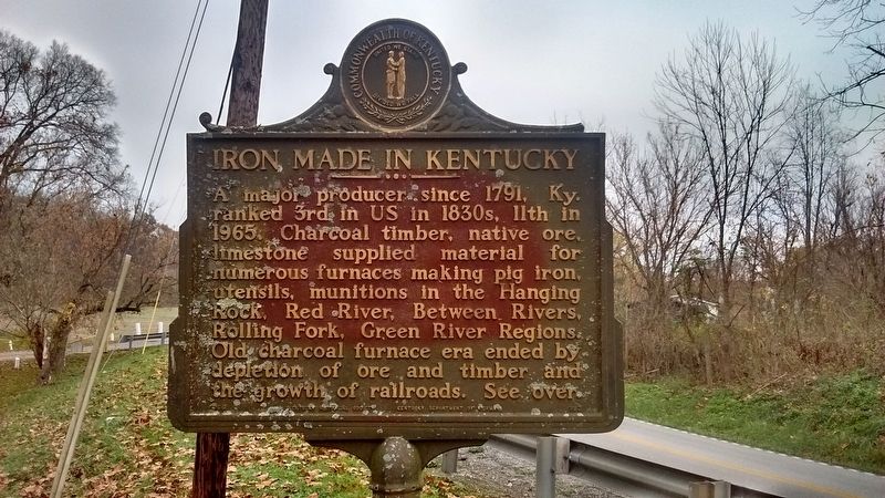
On West Main Street, on the left when traveling west.
Owings House
Built 1811-14 for Colonel Thomas Dye Owings by Benjamin Latrobe, who redesigned the interior of the US Capitol after the British burned it, War of 1812. This house was a center of social life during early 1800's. Henry Clay, . . . — — Map (db m110150) HM
On Main Street (Kentucky Route 211), on the right when traveling north.
Clear Creek Furnace
Built in 1839, 5 miles south, by W. A. Lane and W. S. Allen. Stone stack originally 40 ft. high and 10 1/2 ft. across inside, burning charcoal. Air blast powered by steam. Its iron was used mainly for railway car wheels. . . . — — Map (db m110122) HM
On Main Street (Kentucky Route 211), on the right when traveling north.
Nestled in the foothills of the Allegheny Mountains, Bath County, Kentucky, embraces history while anticipating the future. Formed in 1811, Bath County has many historic homes, churches, iron furnaces and cemeteries dotting the countryside. In fact, . . . — — Map (db m110148) HM
On Camp Street, on the right when traveling south.
Born in Sharpsburg on April 13, 1859, Allen attended Peeks Mill Military Academy and Georgetown College before graduating from the United States Military Academy at West Point in 1882. He was sent to the western frontier, where he led an expedition . . . — — Map (db m110168) HM
On Paula Drive (County Road 190) just west of U.S. 25E, on the right when traveling west.
Dr. Thomas Walker and 5 companions.
employed by the Loyal Land Company, came
into this region April 14, 1750, to locate
lands for settlement in these western reaches
of Virginia. His 1750 journal relates that
he established a camp at this spot . . . — — Map (db m159751) HM
On State Highway 190 at U.S. 25E, on the right when traveling east on State Highway 190.
Rev. Hiram M. Frakes founded this Methodist Settlement in 1925. Begun in a cabin with 13 students, it became an institution for spiritual and educational development of mountain youth. Frakes guided and influenced the entire Middle Laurel Fork . . . — — Map (db m162490) HM
Near Pinnacle Road, on the right when traveling east.
"Cumberland Gap is the strongest position I have ever seen except Gibraltar." These were Union General George W. Morgan's words after viewing the fortification around the Gap. On June 19, 1862, he wrote to Secretary of War Edwin M. Stanton, "The . . . — — Map (db m207707) HM
Near Old Wilderness Road (Kentucky Route 988) at Pinnacle View Road, on the right when traveling north.
During the Civil War, Cumberland Gap was held alternately by Union and CSA armies. USA forces under Gen. George W. Morgan occupied it June 18 to Sept. 17, 1862. Cut off from supplies and surrounded, Morgan with 9,000 men retreated successfully to . . . — — Map (db m50230) HM
Near Sugar Run Overlook Road (Kentucky Route 988).
The next half-mile of trail follows the 1907 roadbed of an "Object Lesson Road." Early in the 20th century, most rural roads, especially here in the Appalachians, were little better than in the days of Daniel Boone. The U.S. Department of . . . — — Map (db m207716) HM
Near Sugar Run Overlook Road (Kentucky Route 988).
The trail ahead follows the 1907 roadbed of an Object Lesson Road. Early in the 20th century, most rural roads, especially here in the Appalachians, were little better than in the days of Daniel Boone. The U.S. Department of Agriculture sponsored . . . — — Map (db m207717) HM
On North 24th Street at Gloucester Avenue, on the right when traveling north on North 24th Street.
Grave of Colonel Arthur Campbell (1743-1811). Statesman, revolutionary soldier, justice, legislator, county lieutenant. Sons, James and John killed in War of 1812. — — Map (db m57938) HM
Near Bartlett Park Road, 0.4 miles south of Pinnacle View Road, on the right when traveling south.
Some of today's Cumberland Gap National Historical Park was created from land where homes, fields, and community buildings once stood. The view from here has changed dramatically over the past century.
Bartlett-Rhodes Park, named for two . . . — — Map (db m205050) HM
Near Old Wilderness Road (Kentucky Route 988) at Pinnacle View Road, on the right when traveling north.
(side 1)
Cumberland Gap
Providing a viable transportation route through the rugged terrain of the Appalachian Mountains, the Cumberland Gap was valued by both Union and Confederate armies during the Civil War. Along with the East . . . — — Map (db m181079) HM
Near Pinnacle Road, on the right when traveling east. Reported permanently removed.
During the Civil War this earthwork - called Fort Rains by the Confederates and Fort McCook by the Federals - was one of many fortifications ringing Cumberland Gap. These defenses were considered too formidable to be taken by direct assault, which . . . — — Map (db m207773) HM
On Pinnacle View Road, 1.7 miles east of Kentucky Route 988. Reported missing.
Where you see a picnic ground today, imagine a seven-sided structure made of earth and wooden walls, approximately 40 feet by 70 feet. The outer walls of this Civil War fort were approximately five feet high with an earth-covered powder magazine . . . — — Map (db m88656) HM
Near Pinnacle View Road, 1.7 miles east of Old Wilderness Road (Kentucky Route 988), on the left when traveling east.
Where you see a picnic ground today, imagine a Civil War fort the size of four football fields side-by-side atop this knoll. The outer walls, made of packed earth faced with logs, rose 10 feet high. Like the other batteries, forts, and rifle pits . . . — — Map (db m205085) HM
Near Pinnacle View Road, 1.1 miles east of Old Wilderness Road (Kentucky Route 988), on the right when traveling east.
At daybreak skirmishing parties of the enemy opened fire...from the adjacent hills....Minie balls are falling within our works. I have no artillery. The snow is falling thickly and the morning is dark. Our men are in the trenches....One man is . . . — — Map (db m207772) HM
On Pinnacle Road, on the right when traveling east.
For travelers who had to walk, the Appalachian mountains seemed like an impenetrable wall, 600 miles long and 150 miles wide. Here at Cumberland Gap you could find both a good way in and a good way out of that rugged labyrinth of ridges, coves, . . . — — Map (db m35880) HM
On Pinnacle View Road, 2.5 miles east of Old Wilderness Road (Kentucky Route 988), in the median.
For travelers who had to walk, the Appalachian mountains seemed like an impenetrable wall, 600 miles long and 150 miles wide. Here at Cumberland Gap you could find both a good way in and a good way out of that rugged labyrinth of ridges, coves, . . . — — Map (db m205056) HM
On Pinnacle View Road, 2.5 miles east of Old Wilderness Road (Kentucky Route 988), in the median.
For travelers who had to walk, the Appalachian mountains seemed like an impenetrable wall, 600 miles long and 150 miles wide. Here at Cumberland Gap you could find both a good way in and a good way out of that rugged labyrinth of ridges, . . . — — Map (db m205084) HM
Near Pinnacle Road, on the right when traveling east. Reported permanently removed.
For the North, Cumberland Gap was a natural invasion route into the South - providing access to vulnerable railroads and valuable minerals and salt works in East Tennessee and southwest Virginia. For the South, the Gap was a gateway for an . . . — — Map (db m207774) HM
On Wilderness Road Trail, on the left when traveling west.
The long crater you see here is all that remains of the Union warehouse that stood here in 1862. Advancing Confederates had to wait 18 hours as scattered munitions continued to explode unexpectedly. By then the once-surrounded Union garrison of . . . — — Map (db m177860) HM
Meriwether Lewis, coleader of the Lewis & Clark Expedition, with a party of Expedition veterans and a Mandan Indian delegation, went through Cumberland Gap in Nov. 1806 en route to Washington to report on the expedition. Over.
Cumberland . . . — — Map (db m33299) HM
On Cirencester Avenue at North 28th Street, on the right when traveling west on Cirencester Avenue.
Founded 1889, this nine-hole golf course is claimed to be the oldest continuously played course in the United States. This semi-private club today has a pro-shop, concessions, and club and cart rentals. — — Map (db m181084) HM
Near North 28th Street, 0.2 miles north of Cirencester Avenue, on the left when traveling north.
One of the oldest in US, founded 1889. The present nine-hole course located on site where original was laid out by the English developers who came 1886 and brought the golf game to this mountain region. In 1899, a financial crash in England took . . . — — Map (db m181083) HM
On 12th Street (U.S. 25E), on the right when traveling north.
Designated by the Kentucky Society of Professional Geologists as a Distinguished Geological Site. Middlesboro is one of only a few cities on the North American Continent located in the basin of a meteorite impact structure.
Sometime over the . . . — — Map (db m33296) HM
On North 20th Street south of Lothbury Avenue, on the right when traveling south.
English colony founded in 1886 by Alexander Arthur. Project financed by English company, the American Association, because of timber and rich mineral deposits here. Almost 100,000 mountainous acres in Va., Tenn., and Ky. purchased for the . . . — — Map (db m33297) HM
Alexander Arthur, 1846-1912, an outstanding figure in history of Middlesboro. He came here in 1885 to prospect, discovering coal and iron ore deposits. President of American Association, formed to carry out his plans for a mining and manufacturing . . . — — Map (db m33298) HM
On 19th Street (Route 2079) at Hurst Road, on the right when traveling north on 19th Street.
Built about 1800 in Yellow Creek Valley, the second brick house in the county, and the oldest one still standing. The bricks were made from clay by slave labor. Home of Rev. John Calvin Colson, "Patriarch of Yellow Creek Valley," preacher, teacher, . . . — — Map (db m181081) HM
The impressive turreted building of the New South Brewery and Ice Company once stood in front of you. Manager William Wallbrecht and brewmaster Mr. Kumli employed dozens of area men to brew beer here. Their leading brands included Pinnacle, Crystal . . . — — Map (db m207778) HM
On Pinnacle Road, on the right when traveling east.
We started just as the sun began to gild the tops of the high mountains. We ascended Cumberland Mountain, from the top of which the bright luminary of the day appeared to our view in all his rising glory; the mists dispersed and the floating . . . — — Map (db m190762) HM
Near Pinnacle View Road, 2.5 miles east of Old Wilderness Road (Kentucky Route 988), in the median.
We started just as the sun began to gild the tops of the high mountains. We ascended Cumberland Mountain, from the top of which the bright luminary of day appeared to our view in all his rising glory; the mists dispersed and the floating clouds . . . — — Map (db m205083) HM
On Englewood Road, 0.2 miles west of North 20th Street, on the left when traveling west.
This is one of the finest examples of Carpenter Gothic architecture in the U.S. The cornerstone was laid in 1890 and the church was dedicated on February 11, 1891. The design is based o blueprints of St. Mary's Church in Middlesborough, England. . . . — — Map (db m181082) HM
On U.S. 25 East, on the right when traveling east.
We went four miles to a large Creek, which we called Cedar Creek,
being a Branch of Bear-Grass, and from thence Six miles to
Cave Gap, the land being Levil. On the North side of the Gap is a
large Spring, which falls, very fast, and just above . . . — — Map (db m210486) HM
On Pinnacle Road, on the right when traveling east.
Cumberland Gap, the break in the ridgeline you see ahead, is far more than just a pass through a long, rugged mountain barrier. For a generation of American pioneers this was the gateway from their old lives and limitations out to a frontier . . . — — Map (db m35899) HM
On Sugar Run Overlook Road (Kentucky Route 988), on the right when traveling north.
This area of the park was once home to dozens of people, with several homes and a school. Evidence of families who once lovingly cared for their homes and land is still visible; stone foundations and chimneys survive, daffodils and forsythia bloom . . . — — Map (db m207881) HM
Lee Branham • Stephen M. Fuson • Marty D. Williams • Steve D. Herrell • Joseph D. Herrell • Thomas M. Cadle • Roger L. Brock • Roland M. Daige • William D. Sweat • Carey Duval • Frankie Rush • Roy J. Lowe • Shelby J. Carter • Carrie C. Sutphin • . . . — — Map (db m214828) WM
Near Pinnacle View Road, 1.1 miles east of Old Wilderness Road (Kentucky Route 988), on the right when traveling east.
The flames of [pro-Union] rebellion will flash throughout East Tennessee, the railroad will be destroyed, the bridges burned, and other calamities...will follow. Landon C. Hayes, letter to Confederate President Jefferson Davis, . . . — — Map (db m205086) HM
On Pinnacle Road, on the right when traveling east.
Two hundred years ago, pioneers poured through Cumberland Gap on their way west to a better life. But not all the traffic on the Wilderness Road was westbound. By the 1820s, drovers pushed huge herds of hogs and smaller herds of cattle and sheep . . . — — Map (db m167001) HM
Near Pinnacle Road, on the right when traveling east. Reported permanently removed.
A natural thoroughfare through the Appalachian Mountain barrier, Cumberland Gap assumed great strategic importance in the Civil War. Both sides sought to control the Gap. It changed hands three times, but no battles were fought. Troops garrisoned . . . — — Map (db m207711) HM
Near Thomas Walker Trail, 0.2 miles east of Pinnacle View Road, on the right when traveling east.
Before trucks and cars in the 1900s, before steam locomotives in the 1800s, before long-hunters' packhorses in the 1700s, there was long-distance traffic crossing the Gap—on foot—going both north and south. No one knows how many centuries Indians . . . — — Map (db m207718) HM
On 12th Street (U.S. 25E) at 14th Street East, on the right when traveling south on 12th Street.
Watts Furnace
Stood ½ mile SW. A pair of blast furnaces built by the Watts Steel and Iron Syndicate, Ltd., 1890-93, and operated until 1898. Each iron shell stack was 75 ft. high with a maximum inner diameter of 17 ft. Using coke fuel and . . . — — Map (db m170830) HM
It will be 100 years or more before Cumberland Gap's restored Wilderness Road trail looks like it did in 1780–1810. The short segment of trail ahead is one of the few places where you can still see the original roadbed, unaltered by the . . . — — Map (db m241292) HM
This memorial is dedicated to the lasting memory of all the men and women who died in defense of the United States of America. dedicated Memorial Day, May 26, 1986
by the people of Bell County. Greater love hath no man than this, that a . . . — — Map (db m214833) WM
Near Chained Rock Road, 4 miles east of 382, on the right when traveling east.
Chained Rock is a boulder formation of Pine Mountain, 2,200 feet above sea level. The Chain, 101 feet long with seen pound links, was carried here by a four-mule team in two trips. It is anchored to the rock with pegs 1½ × 24 inches concreted into . . . — — Map (db m181126) HM
On Bob Madon Bypass (U.S. 25E) at Pine Street (State Highway 66), on the right when traveling west on Bob Madon Bypass.
One of the most important points on the Wilderness Road marked by Daniel Boone in 1775. Ford first used by Indians, then by early explorers and the Long Hunters. After Boone opened the way west, more than 100,000 settlers used the crossing as a . . . — — Map (db m35831) HM
On State Park Road (Kentucky Route 382) west of Chained Rock Road, on the right when traveling north.
On route of Gen. E. Kirby Smith's Confederate invasion of Kentucky, fall 1862, concurrent with that of Bragg to the west. At Richmond Smith defeated USA, then occupied Lexington, Sept. 2. The Battle of Perryville prevented CSA plan to take central . . . — — Map (db m181124) HM
On Kentucky Avenue at Pine Street (Kentucky Highway 66), on the right when traveling east on Kentucky Avenue.
Bell County formed from Harlan and Knox Counties, 1867. Named for Joshua Fry Bell, 1811-70, Congressman, Ky. Sec. of State, Comr. to peace conference in 1861 and State Legislator. He was g. grandson of Dr. Thomas Walker, explorer of Ky. . . . — — Map (db m35871) HM
On Kentucky Avenue at Pine Street (Kentucky Highway 66), on the right when traveling east on Kentucky Avenue.
Bell County, named for Joshua Fry Bell (1811-1870), was formed just after the Civil War in February of 1867 from portions of Harlan and Knox Counties. Pineville, the county seat, being so near the site where pioneers on the Wilderness Road crossed . . . — — Map (db m35875) HM
Near this site where the creek enters the river, on April 17, 1750, Dr. Thomas Walker first viewed the river he named for the Duke of Cumberland. Known as the "Narrows," this area became a significant gateway for travelers on the Wilderness Road. . . . — — Map (db m181163) HM
On State Park Road (Kentucky Route 382), on the right when traveling north.
Following in Their Footsteps
The Wilderness Road was a 200-mil, overland route made famous by legendary frontiersman Daniel Boone. First mapped in 1750 by Dr. Thomas Walker, the route began as a series of braided trails, called traces, created by . . . — — Map (db m181125) HM
On Bob Madon Bypass (U.S. 25E) south of Park Avenue, on the left when traveling south.
Opened Kentucky and the West to rapid settlement and major development. First wagon road built by Kentucky (1796), Crab Orchard to Cumberland Gap. A principal highway, maintained as turnpike (toll road) for 80 years. — — Map (db m212442) HM
On Bob Madon Bypass (U.S. 25E) at Tennessee Avenue, on the right when traveling west on Bob Madon Bypass.
The first to begin operations in Bell County, starting in 1889, with 1500 acres of coal land. Extension of the Louisville and Nashville Railroad to this area in 1888 marked the beginning of a new industrial era. This mine was not a financial . . . — — Map (db m35854) HM
On Asher-Clear Creek Road at U.S. 25E, on the right when traveling east on Asher-Clear Creek Road.
This cemetery was established by pioneers traveling along Boone's Wilderness Road during the late 1700's and early 1800's. These first settlers camped in the bottomland that is now Wasioto Golf Course while preparing to cross the Cumberland . . . — — Map (db m181156) HM
On Bullittsburg Church Road (Kentucky Route 8) near Interstate 275, on the left when traveling north.
It has been called the "Mother
Church" because from 1800-1915
its members organized other
churches within the tri-state area.
Between 1871 and 1873, an outdoor
keyhole baptismal pool was built
of stone masonry at the site of a
natural . . . — — Map (db m133224) HM
On North Jefferson Street at Gallatin Street, on the right when traveling north on North Jefferson Street.
On June 10, 1835, Joseph and Catharine Foster deeded a town lot to the Trustees of the Methodist Episcopal Church, with the stipulation that the property was to be used only for a church. The Burlington Methodist Episcopal Church congregation built . . . — — Map (db m186214) HM
On North Jefferson Street at North Alley, on the right when traveling north on North Jefferson Street.
Completed in 1833, the Burlington
Presbyterian Church was built with separate
front entrances for men and women. It featured
both Federal and Greek Revival detailing. In
the early 1900s, the building was home to the
Local Library Association. . . . — — Map (db m186221) HM
On Gallatin Street, on the right when traveling west.
This outstanding c. 1910 Bungalow home incorporates many Arts & Crafts design elements
including battered porch columns, 3-over-1 window sash, and a low pitched roof. It was built at the
beginning of mini-building boom in Burlington that lasted . . . — — Map (db m133142) HM
On North Jefferson Street at North Alley, on the left when traveling north on North Jefferson Street.
Attorney Erastus Tousey (1798-1863) and his
wife Catherine (1805-1895) built this grand
residence c. 1822. It is one of the most
academically correct examples of Federal style
architecture in Northern Kentucky.
Federal-period details include . . . — — Map (db m186262) HM
On North Jefferson Street south of North Alley, on the right when traveling north.
Joseph Foster built this graceful brick home c.
1831 in the Federal Style. Robert Sandford
acquired it in 1839 and remodeled the home
during the 1840s, adding fine Greek Revival
details such as the colonnaded entry. The
building served as a . . . — — Map (db m186219) HM
On Kentucky Route 18 at Kentucky Route 338, on the right when traveling west on State Route 18.
In June 1799, Boone County's first
court set Craig's Camp as county
seat. The next year, John H. Craig and Robert Johnson donated 74 acres at the Woolper Creek site for a town they called Wilmington. Court held here in a log courthouse in Jan. . . . — — Map (db m133144) HM
Near Sperti Lane, on the right when traveling south.
Born in Covington to Italian
immigrants, he graduated from
the University of Cincinnati
in 1923. He was the director of
Institutum Divi Thomae, a medical
research foundation, from 1935 to
1988. Sperti invented well-known
pharmaceutical . . . — — Map (db m133141) HM
Near Washington Street (Kentucky Route 18) at Jefferson Street, on the right when traveling west.
Boone County Courthouses Through the Years
1n 1817, Boone County replaced its first log courthouse with a brick structure, which was remodeled in 1828 and again in 1878. The present courthouse was built in 1889 for $19,740. The courthouse . . . — — Map (db m134040) HM
Near Washington Street (Kentucky Route 18) near Jefferson Street (Kentucky Route 338).
Boone County was established in 1799 and the County Court held its first meeting in June of that year, where The Court proceeded to fix on a place for the Seat of Justice on 74 acres offered by Robert Johnson and John H. Craig. Initially known as . . . — — Map (db m134232) HM
Near Washington Street (Kentucky Route 18) near Jefferson Street, on the right.
From its earliest days, Burlington was the hub of a community rooted in farming. Prior to World War II, the majority of people in Boone County lived and worked on farms and the livelihood of nearly everyone else was somehow connected to farming. By . . . — — Map (db m134233) HM
On North Jefferson Street (Kentucky Route 338) west of Temperate Street, on the right when traveling west.
One of several log structures on North Jefferson Street, this c. 1860 single pen log house was once part of the Willis Graves estate. It is named after James Hogan, who owned it from 1881 to 1912. The house was rehabilitated as a craft shop in 1992. . . . — — Map (db m201101) HM
On North Jefferson Street north of North Alley, on the right when traveling north.
This brick residence has seen many uses since it
was built, including that of parsonage. It was
built c. 1840 by James M. Runyan (1807-1859),
one of Burlington's mid-nineteenth century
blacksmiths. The structure features a side
passage plan . . . — — Map (db m186269) HM
On Washington Street (Kentucky Route 18) at Union Square, on the right when traveling west on Washington Street.
Interesting details abound in this spacious house originally built c. 1867 for Charles L. and Henrietta Latimer, and updated in the early 20th Century. The Latimers migrated to Missouri before 1870 and the home often changed hands. Edmund Walden . . . — — Map (db m186252) HM
Near Taylor Drive north of Burlington Pike (Kentucky Route 18).
Mary Ingles was a young pioneer wife taken captive in a Shawnee raid in July 1755. Brought by her captors to Big Bone Lick, here in Boone County, she escaped in October 1755. Mary then fought her way through 800 miles of uncharted wilderness along . . . — — Map (db m175111) HM
On Kentucky Route 18 at Kentucky Route 338, on the right when traveling west on State Route 18.
There has been a courthouse on this site
since 1799 and the present one is the third
built on the site. Designed by the McDonald
Brothers of Louisville, the Renaissance
Revival style building was completed for
about $20,000. The courthouse . . . — — Map (db m133151) HM
On Bullittsville Road at Park Street, on the right when traveling south on Bullittsville Road.
Established in 1819, this historic graveyard was Burlington's first community cemetery. It protects the remains of over 250 Boone County residents including County Judges and other leading citizens and businessmen from the last two centuries. Among . . . — — Map (db m175115) HM
In memory of all the slaves in Boone County,
those who helped them, and the slaves’ descendants
who remember & honor them and their legacy.
Dedicated 21 March, 2005 by the Problem Solving Team, a diverse
group of students, grades five . . . — — Map (db m79290) HM
On Lower River Road, on the right when traveling north.
One of only a few
remaining early 19th century towns along the 981-
mile course of the Ohio River. The Rabbit Hash
National Registry encompasses 33 acres of
this linear rural/agricultural/commercial village,
characterized by its eclectic . . . — — Map (db m79231) HM
On Union Square north of Washington Street (Kentucky Route 18), on the right when traveling west.
Built for Elijah Kirtley c.1830, probably by Benjamin Piatt Fowler, this substantial brick I-House served as the Boone House Tavern until 1870. It later became the residence of Fountain Riddell, attorney, state legislator and founder of the Boone . . . — — Map (db m186256) HM
On Washington Street (Kentucky Route 18) at Garrard Street, on the right when traveling west on Washington Street.
Built c. 1887 by Senator Samuel Walker Tolin (1849-1933), this brick residence retains the finest Folk Victorian detailing in Burlington. Tolin was a well-known attorney and Kentucky State Senator in 1902 who practiced law out of this building for . . . — — Map (db m201103) HM
On North Jefferson Street south of North Alley, on the right when traveling south.
This house was built c. 1884 for Hayden Polk
Stephens (1844-1932), an up and coming
Burlington lawyer. It is an outstanding example
of a late 19th Century Burlington residence. H.P.
Stephens later became a Judge in Kenton County,
where he died . . . — — Map (db m186267) HM
On Brlngon Pike (Kentucky Route 18), on the right when traveling south.
James and Martha Macomb Dinsmore
moved from La. to raise their three
daughters here. Completed in1842,
the main house served as the center
of a typical large, antebellum Boone
Co. farm. tenants and slaves raised
grains, grapes, sheep, and . . . — — Map (db m79304) HM
Formed by legislative act from a part of Campbell County. Names for Daniel Boone, renowned Kentucky pioneer-explorer.
Big Boone Lick, graveyard of the mammoth, was discovered in 1729 by Capt. M. de Longueil. In 1756, Mary Inglis was brought . . . — — Map (db m61867) HM
On Center Street at Girard Street, on the right when traveling north on Center Street.
First Baptist African American
Church in Florence was founded
in 1870 by the Trustees of the
Colored Baptist Association. The
congregation was active for over
100 years and was essential to
formerly enslaved people & Freedmen
in the area. . . . — — Map (db m180718) HM
On Hopeful Church Road (Kentucky Route 842) east of Clayton Road, on the right when traveling east.
Hopeful Evangelical Lutheran
Church was founded on Epiphany
Day. 1806. by German-speaking
families from Madison County, Virginia.
Called “the Mother of Lutheranism
west of the Allegheny Mountains,”
it is the oldest Lutheran church . . . — — Map (db m136081) HM
On Main Street at Dixie Highway (U.S. 42), on the right when traveling east on Main Street.
John Uri Lloyd (1849-1936). Born in NY, came to Boone Co. KY in 1853. Pharmacist, chemist, inventor & electric herbal medicine pioneer. Wrote series of novels based on local folklore including Stringtown on the Pike in 1900. Founded . . . — — Map (db m201104) HM
On Dixie Highway (U.S. 25) at U.S. 42, on the right when traveling south on Dixie Highway.
Union troops, had built forts around Covington to repel expected attack from CSA troops under Gen. Heth. Detachment of 101 CSA troops camped at Snow's Pond attacked here by scouting party of 53 USA cavalrymen Sept. 17, 1862. In the skirmish 1 Union, . . . — — Map (db m133190) HM
On Kentucky Route 8, on the left when traveling east.
1937 Flood at Constance
The Ohio River reached its peak
on Jan. 26 at 79.9 ft. surpassing
the 1884 record. Constance was the
hardest hit town in Boone Co. but
there were no fatalities. Route 8
between Constance & Taylorsport
was almost . . . — — Map (db m133629) HM
On Kentucky Route 8, on the right when traveling east.
American Airlines flight 383, tail
#N1996, was making an approach
in rain when it crashed into this
hillside on November 8, 1965 at
7:01 p.m. The 3-engine Boeing 727
Astrojet was en route from New York
to Cincinnati. 58 people perished
four . . . — — Map (db m133173) HM
On Petersburg Road (Kentucky Route 20) at Aviation Boulevard, on the left when traveling east on Petersburg Road.
TWA flight 128, tail #N821TW, was
making an approach in light snow
when it crashed into an orchard
approximately 1,000 feet north of
here, on November 20. 1967 at 8:57
p.m. The four-engine Convair 880
was en route from Los Angeles . . . — — Map (db m133136) HM
On North Bend Road (Kentucky Route 237) at Wright Boulevard, on the right when traveling south on North Bend Road.
TWA flight 694, tail #N93211, had taken off from the airport when
it was struck by a private DC-3
& fell to the ground approximately
750 feet west of here, on January
12, 1955 at 9:04 a.m. The TWA
Martin 202A was en route to
Cleveland, Ohio . . . — — Map (db m133123) HM
On Belleview Road (Kentucky Route 20/3608) 0.4 miles east of Mill Street, on the right when traveling north.
Charles Clinton Fleek (1947-1969). Sergeant Charles Clinton "Chalkie" Fleek was born on August 28, 1947 in Petersburg, KY. He served in the U.S. Army 25th Infantry Division in South Vietnam and is the only medal of Honor recipient from Boone . . . — — Map (db m201099) HM
4107 entries matched your criteria. Entries 101 through 200 are listed above. ⊲ Previous 100 — Next 100 ⊳