"Neverless a fountain or a cistern wherein is a gathering of water shall be clean" - Leviticus 11:36
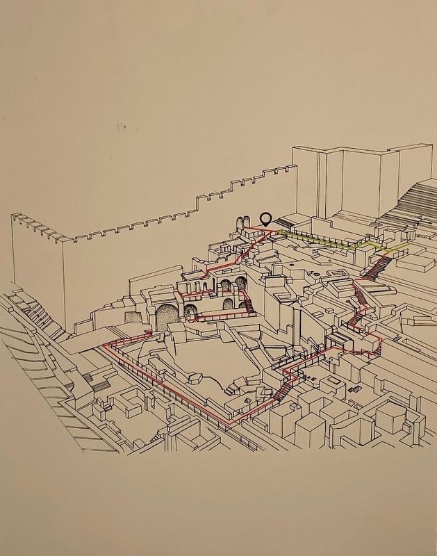
The Mikveh Trail passes through excavated remnants of various structures. Signs along the trail explain archaeological features, . . . — — Map (db m219248) HM
The Mishnaic Tractate Mikva'ot details all the rules, formulated in Second Temple times, regarding ritual purification baths. These rules are based on the following conditions that made the mikveh ritually valid: It had to be connected to the . . . — — Map (db m219312) HM
The western Huldah Gate was built in the Second Temple period as a double gate. Most of the gate is blocked today with only part of one of the arches still visible. The façade of the gate was decorated with floral and geometric motifs when it was . . . — — Map (db m219896) HM
The two burial caves in front of us date to the latter part of the First Temple period. These caves were found devoid of remains and were part of Jerusalem's western cemetery which was hewn outside the city walls.
It was customary at the time . . . — — Map (db m219040) HM
In tribute to Poles buried in this cemetery, civilians and soldiers of General Vladyslaw Anders Polish II Corps
Former Prisoners of War and Inmates of Soviet Lagers who died on their way to homeland in the years World War II and after
Poland . . . — — Map (db m219058) WM
The ground floor of a royal structure, destroyed in a fierce conflagration during the Babylonian conquest of the city in 586 BCE. Twelve large, clay store jars (pithoi), which probably contained wine or oil, were discovered on the floor of the . . . — — Map (db m219650) HM
Two superposed, vaulted rooms, dating to the Second Temple period (first century CE), were preserved to a height of two stories. The rooms are part of a public building, whose continuation lies beneath the street. An opening in the western wall of . . . — — Map (db m219811) HM
On this site was a temporary prison in which members of the Jewish underground forces were detained for questioning. Amongst those detained were Betar and I.Z.L members who blew the shofar at the Western Wall at the close of Yom Kippur. — — Map (db m220144) HM
An Ottoman military camp, presently used by the Israel Police. Site of Herod's luxurious palace at the end of the Second Temple period. — — Map (db m220145) HM
The remains of the east wall of the Umayyad Palace, as well as its wide gate which has been filled with stones, served as foundations for the medieval and Ottoman city walls. During the archaeological excavations the blocking of the gate was . . . — — Map (db m219246) HM
A residential building from the Byzantine period (6th - 7th centuries CE), preserved beneath the Umayyad Palace. Surviving parts are courtyards, rock-cut cavities and (partly reconstructed) residential rooms with plastered walls and mosaic floors.
. . . — — Map (db m219245) HM
This site owes its fame to Jesus' healing of the paralytic, a story told in John's Gospel:
"One man was there who had been ill for thirty-eight years. When Jesus saw him lying there... he said to him: 'Do you want to be made well?' The sick man . . . — — Map (db m222074) HM
Sont au service de l’Eglise dans 21 pays d’Afrique. Ici depuis 1878, ils se veulent au service de l’unite.
Serve the church in 21 African countries.
In 1878, they came to Jerusalem, where their aim is to work for . . . — — Map (db m220239) HM
One of the stones in the wall, bears a Hebrew inscription "and you shall see and your heart shall rejoice and their bones like grass shall..." - a biblical verse somewhat altered.. The circumstances of the inscription are unknown.
(Hebrew . . . — — Map (db m219240) HM
In the course of the reconstruction of the Jewish Quarter the 1970s, archaeological finds dated to different periods include numerous architectural elements. These were found throughout the Jewish Quarter in secondary use in later structures, and . . . — — Map (db m220137) HM
From the 7th century CE, Jerusalem's architectural tradition continued to develop, while utilizing earlier traditions and reusing architectural elements. Over the years new architectural and artistic styles appeared. one of the innovations was the . . . — — Map (db m220135) HM
During 1930-1948 the grocery store of brothers Avraham and Ben-Zion Maimaran operated in this building. Both were born in the Jewish Quarter to one of its oldest families.
The store served as a social and commercial center. In 1948 it became a . . . — — Map (db m219070) HM
Commander of the Jewish Quarter in Israel's War of Independence in 1948 and named "Worthy of Jerusalem." The City of Jerusalem and his comrades in arms have chosen this site to commemorate their commander Moshe Rusnak.
Who with wisdom and faith, . . . — — Map (db m220138) WM
Collapsed on the paved street are stones of the western wall of the Temple Mount enclosure. They were hurled down by the soldiers of the Roman Legion after the destruction of the Temple on the ninth day of the month of Av, 70 CE.
(Hebrew and . . . — — Map (db m219242) HM
This is a Second Temple period home that was situated in the opulent Herodian Quarter. Excavations revealed burnt wooden beams and soot. Apparently it burned down in the great fire the Romans started in Jerusalem after the Temple's destruction (70 . . . — — Map (db m219153) HM
The University of North Carolina at Charlotte has been conducting archaeological excavations at this location for more than a decade, with the discovery of the remains of a major multi-roomed structure from the Second Temple period (late 1st century . . . — — Map (db m220181) HM
The Foundation Stone sits at the peak of Mount Moriah above the Western Wall. According to tradition, the world was created from this stone, the Binding of Isaac took place on it, and King Solomon built the First Temple around it as "a house for the . . . — — Map (db m221891) HM
A pier of large stones which originally supported the western springer of Robinson's Arch. The pier enclosed four cubicles that served as shops, opening onto the paved street.
(Hebrew and Arabic not transcribed) — — Map (db m219239) HM
Set up by a pharmacist called Rubovitch and acquired in 1938 by pharmacist Willy Rosenberg. Operated during the War of Independence and all of Israel's wars. Owned by the family since 1956. — — Map (db m220093) HM
In the diary of excavations, given by Father Germer-Durand, we can read in 1890:
-September 22: taken in double the stamping of the letters' traces on the lintel.
-September 26: taken a photograph of the inscription.
Emile . . . — — Map (db m220201) HM
This splendid Neo-Classic building was erected in 1885 by the German banker, Johannes (Jacob) Frutiger as his private residence and named by him "Mahanayim" (Genesis 32:2). From 1896 it was the Evelina De Rothschild School. Among the buildings . . . — — Map (db m219963) HM
The Assumptionists came to the Holy Land for the first time in 1882, bringing here 1013 pilgrims in two ships.
In order to accommodate the pilgrims, they built Notre Dame de France guesthouse and obtained the opening of New Gate . . . — — Map (db m220197) HM
This splendid burial monument dates to the end of the Second temple period. The lower part of the monument is hewn and the upper part is constructed. The name derives from the biblical verse that tells of Absalom's construction of a monument for . . . — — Map (db m63866) HM
English Translation of Text on Marker:
The temple which he built, Achish (Ikausu) son of Padi, son of YSD, son Ada, son of Ya'ir, ruler of Ekron, for PTGYH his lady. May she bless him, and protect him, and prolong his days, and bless his . . . — — Map (db m142015) HM
Built in 1900 by Sa'eed and Omran Dakkak, it was one of the first houses to be built in the area. The house was designed by a Turkish architect infusing Turkish and Islamic building styles. The family lived in the house until 1930; It was then . . . — — Map (db m220180) HM
"Jerusalem, hills enfold it, and the Lord enfolds his people now and forever" (Psalms 125:2)
Jerusalem was first established on the hill on which you are now standing almost 4,000 years ago, during the Canaanite . . . — — Map (db m63924) HM
English Text:
This is the most remarkable cave at this site, as it contains some of the most important archaeological finds in Jerusalem.
The plan of room on the right is rectangular, measuring 2.0 x 3.7 meters. Three raised burial . . . — — Map (db m141531) HM
The Empress Eudocia built the original church in the middle of the fifth century to house the Relics of St. Stephen, the first Christian Martyr and the adjoining Monastery complex served as a meeting place for 10,000 monks in 516. After a Persian . . . — — Map (db m220373) HM
He decided to dedicate his life and his fortune to the works of the Holy Land. He built and subsidized the French hospital of Saint Louis, opened in 1881.
During the Pilgrimage of Penance, organized by the Assumptionists, he was . . . — — Map (db m220191) HM
Etz Haim Yeshiva founded this neighborhood in 1932 according to architect Dov Sonnenfeld design with dozens of flats and a magnificent synagogue. Distant from other neighborhood at the time, only three building were constructed with a terrace along . . . — — Map (db m220105) HM
Born in Bethune, Pas-de-Calais, France.
He was ordained a priest in 1889 and sent to Jerusalem. He was the architect of the Hotellerie Notre-Dame de France from 19890.
He also made plans for Our Lady of the Spasm in 1891 . . . — — Map (db m220185) HM
He was born in 1918 in Munich, Germany, from an Alsatian father, protestant and a German mother, Jewish. He was baptized at 16, and joined the Congregation of the Assumptionists at age 23.
He was ordained a priest in 1948 and sent . . . — — Map (db m220187) HM
Garden of Olives
Jesus went out with his disciples across the Kidron valley to a place where there was a garden, which he and his disciples entered. (Gospel of John 18:1)
“Gethsemane, a place where the Savior prayed before . . . — — Map (db m44596) HM
The complex was built in the 1920's-1930's for residence and commerce as part of the Jaffa Road and Romema neighborhood commercial development. It comprises buildings with commercial spaces on the ground and residence on the upper-floors, where . . . — — Map (db m220104) HM
House of the Emress Taitu
Built in 1903 in the Neo-Classic style by Empress Taitu, wife of King Menelek II of Ethopia. Atop the building is the Empress' symbol, a sun and crown. Served as the residence of the Turkish Governor and since 1930s, has . . . — — Map (db m219972) HM
Born into a family of Chabad Hassidim, Frumkin made aliya from Vilma at the age of 9. He lived in the "Havatselet Court" in Jerusalem's Old City. In 1863 he founded the "Havatselet" newspaper, remaining the editor until 1911. he fought the fanatics . . . — — Map (db m220092) HM
High quality two buildings for rent built in 1932 by Issa Musa, with well-designed details, including stone supported balconies and stylish iron bars. Arabs and Jews used to live her together. — — Map (db m220103) HM
[Text in Hebrew …]
[Text in English:] Jaffa Gate is the westernmost of the gates in the walls of Jerusalem. It is so named as the starting point of the road to Jaffa port. Its Arabic name, Bab al-Khalil, meaning “Hebron Gate,” . . . — — Map (db m44853) HM
This is a burial complex from the Second Temple period. The facade of the cave features the relief of a gable resembling the roof facade of a sacred building. The decorative style is drawn from Hellenistic art, which influenced Jewish burial . . . — — Map (db m63932) HM
We are a small family run heritage hotel offering a unique Palestinian cultural ambience and service. Our hotel started in 1950 as a small guesthouse. Formerly, the location was once an Ottoman police station, a family house and a school . . . — — Map (db m219011) HM
The model before you recreates Jerusalem in 66 CE. In that year, the Great Revolt against the Romans erupted, resulting in the destruction of the city and the Temple. The ancient city was then at its largest, covering an area of ca. 445 acres (more . . . — — Map (db m199101) HM
The Burial Caves date from the First Temple Period. Throughout many generations, they served affluent Jerusalem families as a location to bury their dead. The deceased was placed on a stone slab with a special indentation for the head. At the end of . . . — — Map (db m63881) HM
Latin Text that appears on Stone:
... )s Tiberivm
... Pon)tivs Pilatvs
... Praef)ectvsivda(ea)
English Translation of Text, provided, but not seen on Stone:
... building in . . . — — Map (db m88742) HM
Gate of the Tribes: The Gate was built with the wall by Sultan Suleiman the Magnificent during 1538-1539. The stone reliefs on its facade gave the Gate its name.
(Hebrew and Arabic text not transcribed) — — Map (db m220243) HM
During Israel’s War of Independence, 1948-49, more than
4,800 volunteers, including 168 Christians, came from 59
countries to Israel’s aid. Some had served as crew on the 10
American-purchased Aliyah Bet ships that brought so many
Holocaust . . . — — Map (db m134663) HM
The meeting place of three fortification elements from the First Temple period (tenth-sixth centuries BCE): a wall of large stones that is part of the Small Tower - most of it is hidden beneath the street - and above it, the Byzantine tower (1), a . . . — — Map (db m219345) HM
English Text:
This was the first Jewish neighborhood built outside the walls of the old city of Jerusalem (1860). It was successfully defended by the Haganah during the disturbances of 1929, 1936-1939 and during the War of Independence. . . . — — Map (db m141985) HM
The Restoration Project of the Second Temple period
Ritual Baths and Water Conduits
in the area south of the Temple Mount Enclosure — — Map (db m63951) HM
A modern office building erected by the Sansour brothers from Bethlehem in 1929. It is a triangle structure built around a courtyard and its elegant design interweaves modern lines with Neo-clasic ornamentation. On its ground floor was the . . . — — Map (db m220096) HM
"You will be amazed at Jewish youth in Palestine...they have the look of freedom." Stephen Theodore Norman, 1918-1946. Last descendent of Theodor Herzl. Stephen Norman was the grandson of Theodor Herzl and his last descendent. Born in Vienna, . . . — — Map (db m134639) HM
A two-story eclectic style residence house designed by architects Patsis and Spiro Khouri and built in 1927-1928 for the brothers Ezra and Pinchas Kukia. Shortly after its completion it was converted into Tel Aviv Hotel, which became Ron hotel, . . . — — Map (db m220095) HM
On the 12 of Adar 1 5708, February 22nd 1948 there was an explosive attack on Ben Yehuda Street. The attack was planned by Abed Al-Kader El Husseini and was carried out by six soldiers that defected from the British army using British army vehicles . . . — — Map (db m220097) HM
"He burned the House of the Lord, the king's palace, and all the houses of Jerusalem; he burned down the house of every notable person." (II Kings 25: 9)
This residential quarter went up in flames with the rest of . . . — — Map (db m63933) HM
Then delivered he him therefore unto them to be crucified
and they took Jesus, and led him away.
And he bearing the cross went forth into a place called Golgatha
where they crucified him and two other with him, on either
side one, and Jesus in . . . — — Map (db m95071) HM
The Ottoman Sultan Suleiman the Magnificent appointed Sheikh Ahmad Al-Dajani as the guardian of Nabi Daud Tomb (King David). For 400 years, the family have been responsible for the tomb and its surroundings. Many family members are buried in the . . . — — Map (db m220110) HM
The enigma of QORBAN
The lintel placed above the door of the store was discovered on September 18, 1890. He was found near a large silo, in 1892 became burial vault.
The measure of the lintel is: 2.40 m long; Its height: 40 cm and its . . . — — Map (db m220200) HM
Here Dwells Ahiel in a Four Room House
"He (David) had houses made for himself in the City of David..." (1 Chronicles15: 1)
The name 'Ahiel' appears on potsherds found among the ruins of this house. The House . . . — — Map (db m65296) HM
"And Hiram king of Tyre sent messengers to David, and cedar - trees, and carpenters, and masons; and they built David a house" (II Samuel 5: 11)
Excavations in progress at this site since May 2005 conducted by Eilat Mazar, . . . — — Map (db m64064) HM
At the end of War of Independence (1948) access to Mount Zion became dangerous due to Jordanian sniper fire directed at the area. In order to ensure the smooth passage of troops, supplies and equipment, a trench was dug from the neighborhood of . . . — — Map (db m219055) HM
"The other events of Hezekiah's reign, and all his exploits, and all his exploits, and how he made the pool and the conduit and brought the water into the city, are recorded in the Annals of the Kings of Judah" (II Kings 20:20) . . . — — Map (db m63905) HM
English Text:
Two smaller silver objets were discovered in the bone repository, rolled up like tiny scrolls, to be worn as amulets. After the scrolls were unrolled, it emerged that they were made of pure silver, measured 27 x 97 . . . — — Map (db m141591) HM
"...the city shall be rebuilt on its mound, and the fortress in its proper place" (Jeremiah 30:18)
The inhabitants of ancient Jerusalem once built their homes on this hillside. The earliest structure unearthed here . . . — — Map (db m63928) HM
Built in 1906 for the elders of Jerusalem as a magnificent courtyard building on the main Jaffa Road, with stone details and a wide external staircase leading to the building's entrance. Evacuated in the 1970s, in 2014 the building underwent a . . . — — Map (db m220102) HM
The Shrine of the Book is home to the Dead Sea Scrolls, among them, the world's oldest copies of biblical books. It is also home to rare biblical manuscripts from later periods, such as the Aleppo Codex. Besides the two-thousand year old scrolls, . . . — — Map (db m199103) HM
"And David said on that day: 'Whosoever smiteth the Jebusites, and getteth up to the gutter...'" (II Samuel 5:8)
We are standing at the entrance to a subterranean water system. The Gihon Spring was Jerusalem's . . . — — Map (db m63947) HM
This vault was built in 1892 in an old silo of 8m. long, 10m. wide, and 5m. high. Here, are waiting for the resurrection, 24 pilgrims, 25 nuns, and 24 Assumptionists.
Ce caveau a été aménagé en 1892 dans un ancien
silo . . . — — Map (db m220189) HM
English Text:
Seven burial caves from the late First Temple period were found at the site. The caves, which were hewn into the cliff above which the Scottish Church of St. Andrew was built, were found partially destroyed by later . . . — — Map (db m141978) HM
They were founded in Nimes, France, by Fr. Emmanuel d'Alzon (1810-1880)
The Assumptionist Fathers, in 1845
They are present in thirty countries around the world, where they devote themselves to teaching, social and . . . — — Map (db m220194) HM
The Divine presence never moves from the Western Wall.
Jewish tradition teaches that the Temple Mount is the focal point of Creation. In the center of the mountain lies the “Foundation Stone” of the world. Here Adam came . . . — — Map (db m44722) HM
Two ancient synagogues reside in this complex. Ha-Ari Synagogue, by tradition the birthplace in 1534 of Kabbalist Ha-Ari Ha-Kadosh, and Or Ha-Haim Synagogue, which is named for Rabbi Haim ben-Atar of Morocco, who founded Knesset Yisrael Yeshiva here . . . — — Map (db m220142) HM
Remains of a magnificent main road from the Roman-Byzantine period serving throughout time until today as a major thoroughfare for shopping. — — Map (db m220140) HM
Built in the time of Sultan Suleiman the Magnificent in the 16th century. In Arabic: Bab al-Nabi Daoud, due to its proximity to King David's Tomb.
(Hebrew and Arabic text not transcribed) — — Map (db m219060) HM
This typical Jerusalem courtyard building, with three wings, was erected in 1895 by Solomon Feingold. In 1908 it housed the city's first movie theater. In the early British Mandate period the offices of "Do-Ar Hayom" newspaper were located here, as . . . — — Map (db m220089) HM
This trade and business building was designed by Italian architect Marcello Piacentini in 1934 in a combined classic and international style. The façades of the shops on the ground floor are convex built of coarse stone. The building outline . . . — — Map (db m220086) HM
During the British Mandate period, this was the site of the clinic of the orthopaedic surgeon Dr. Treu. On June 7, 1946, Dr. Yisrael Sheib "Eldad", one of the Lehi leaders imprisoned in the Latrun detention camp, was brought here for treatment. A . . . — — Map (db m220171) HM
Pediatrician Helena Kagan (1889-1978) founded pediatrics in Jerusalem, including mother and child care clinics and day-care centers for Jews and Arabs alike. Active in the Jewish women organization that joined later WIZO. Israel PrizeLauriate, 1975. . . . — — Map (db m220156) HM
Designed by architect Re'uven Trostler and built in 1996 for the Israeli Medical Association, a three-floor building with a rounded entrance. Jerusalem municipality bought the building and turned it to a cultural center.
(Hebrew and Arabic . . . — — Map (db m220151) HM
Built in 1882 by the architect and archaeologist Conrad Schick for his family. The central building is typical to rich Palestinian homes of the time, with thick stone walls, niches and vaulted ceilings, with archaeological items attached to the . . . — — Map (db m220163) HM
The Syrian-Orthodox community built this house in 1868 and leased it in 1895 to the US Consulate, that moved to what was known at the time the street of the consulates. Changes they made included the removal of the tile-roof and opening the ground . . . — — Map (db m220173) HM
Military leader and Israeli Government Minister. Was born in the capital of Israel, Jerusalem.
From early on in life, he defended his people like the emblematic two sheaves of wheat and a sword, a symbol which has accompanied generations of . . . — — Map (db m220147) HM
Typical Jewish neighborhood, founded in 1875, the row houses are built around a square courtyard in the center of which are cisterns. The neighborhood, which has two entry gates, was intended for Ashkenazim and Sephardim, and each community had . . . — — Map (db m220098) HM
384 entries matched your criteria. Entries 101 through 200 are listed above. ⊲ Previous 100 — Next 100 ⊳