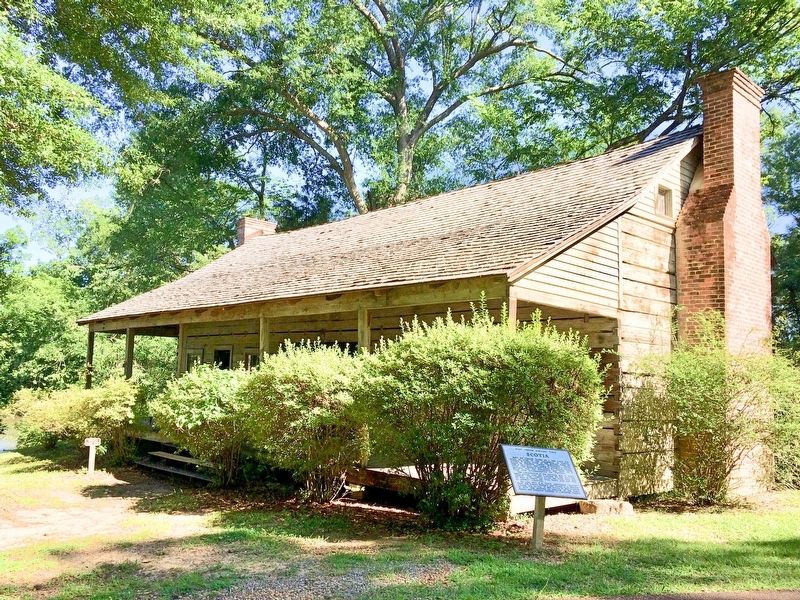
Built by Thomas Foster as a one room log house in 1768 in the community of Scotia, located 5 miles south of the present town of Roxie in Franklin County, Mississippi. About 1789 a "dog trot" was added to connect a second room. The upstairs was added . . . — — Map (db m104291) HM
The town of Grand Gulf began in the 18th century as a small British settlement. By 1828 it had grown to a village of three stores, one tavern, and several houses. There was a stage line to Port Gibson and steamboats stopped at its wharves. . . . — — Map (db m105720) HM
The once active spring provided a natural stopping place for travelers on the Natchez Trace and helped establish and sustain the rural community of Rocky Springs. The 25 square mile town, which included a post rider relay station prospered for . . . — — Map (db m97265) HM
At the end of this trail is evidence of a once thriving rural community. First settled in the late 1790's, the town grew from a watering place along the Natchez Trace, and took its name from the source of that water -- the Rocky Spring. In 1860, a . . . — — Map (db m80147) HM
About 14 miles west at the mouth of Bayou Pierre is the old river port settled by Peter Bryan Bruin in 1788. It was visited by Aaron Burr in 1807. Grant landed there in Vicksburg Campaign of 1863. — — Map (db m103797) HM
Of the three original mounds overlooking Bayou Pierre, only one remains. A pyramidal platform, Mound A is currently 16 feet tall. Excavations indicate that Native Americans built the mound in multiple stages during the Coles Creek Period, from AD . . . — — Map (db m103785) HM
This local area was once a part of the mighty Choctaw Nation. The Choctaw Indians relinquished when they signed The Treaty of Commissioner's Creek in 1802. Among the white men who signed this treaty were David Hunt and Daniel Burnet. The first . . . — — Map (db m139187) HM
The Caucasian habitation of Claiborne County began as a settlement on the banks of Bayou Pierre, a venture which perished in 1729. Pioneers again attempted to settle Grand Gulf in 1775. In 1802 the County officially established and named for the . . . — — Map (db m139493) HM
An outbuilding in size and architectural detail to this one was constructed by Samuel Gibson, apparently at the same time as his residence circa 1805. The original dependency was probably used as a plantation office, school or weaving room. Since . . . — — Map (db m137981) HM
1108 Church. Ca. 1830 Greek Revival. This home built by Judge Coleman was the site of a large political rally held for Henry Clay, during one of his early visits to Port Gibson. — — Map (db m139459) HM
1207 Church Street. Port Gibson's largest mansion. This neoclassic house exemplifies the grandeur of antebellum days. The house with gardens and dependencies originally occupied the entire block. Named Oak Square because of the massive Oak trees . . . — — Map (db m139025) HM
Incorporated in 1811, Port Gibson was first settled by Samuel Gibson, who acquired property along Bayou Pierre from the Spanish in 1788. First known as Gibson's Landing. Port Gibson, selected as the Claiborne County seat in 1803, had the state's . . . — — Map (db m103803) HM
This brick structure is thought to have been built ca. 1805 as a residence for Samuel Gibson, the founder of Port Gibson. It was moved from its original site to this location in 1980. Typical of the dwellings built during the early settlement of . . . — — Map (db m137975) HM
From here you see where the nineteenth century path intersects with the auxiliary "plantation road." During the battle, this road provided the Union command a direct link with their left flank engaged along the Bruinsburg Road to the north. . . . — — Map (db m143713) HM
Originally named "The Hill," this house was built by Peter Aaron Van Dorn, ca. 1828. Located on one of Port Gibson's highest hills, the brick and cypress house was constructed from the resources presumed to be local. Distinctive features of the . . . — — Map (db m137977) HM
Ca. 1830 Federal. Built by Peter A. Van Dorn, New Jersey native who purchased this land in 1826. In 1817 Van Dorn was first clerk of the State House of Representatives. Boyhood home of Van Dorn's son, Confederate General Earl Van Dorn. — — Map (db m143065) HM
Windsor Mounds includes four rectangular platform mounds overlooking Bayou Pierre. Mound A, visible from the road, is the largest at over 30 feet, and has a ramp extending toward the east. Mounds B, C, and D range in height from 3 to 16 feet. The . . . — — Map (db m103783) HM
Smith Coffee Daniell II, a successful cotton planter, completed construction of Windsor in 1861. Daniell owned 21,000 acres of plantation land in Louisiana and Mississippi. Ironically, he died in April 1861, only weeks after completing his . . . — — Map (db m70541) HM
Center of early trade on Chickasawhay River with Gulf Coast. Served during Civil War as location of hospital and prison camp and temporary refuge of the State Government. — — Map (db m84213) HM
A trade town for local
cotton farms during the
19th century. Est. 1846 and
incorp. 1852. Declined
following shifts in trade to
the town of West Point on
the M. & O. R. R. and to the
nearby village of Abbott. — — Map (db m235115) HM
E. 10 mi. Plantation home built c. 1852 by Geo. H. Young. Octagonal cupola. Gen. N.B. Forrest visited here during the Civil War. National Fox Hunters Assn. organized here. — — Map (db m50160) HM
County seat of Coahoma County, was founded
in 1869 by John Clark, for whom the town was
named. Situated in one of the most fertile
regions of the world, it has grown into one
of the leading cities of the Yazoo Mississippi
Delta. It . . . — — Map (db m89749) HM
Founded 1868 at crossing of Indian trails and on possible route of De Soto's expedition. Chartered 1882. Coahoma co-county seat, 1892; sole seat since 1936. Home of Gov. Earl Leroy Brewer. — — Map (db m89925) HM
Built in 1916, this Italian style villa was designed by Memphis
architect Bayard Cairnes and was the home of local attorney J.W.
Cutrer and his wife Blanche Clark Cutrer, daughter of Clarksdale
founder John Clark. Named Belvoir by the Cutrer . . . — — Map (db m89922) HM
When first recorded, Salomon Mounds had three (possibly four) large platform mounds and as many as eight smaller mounds arranged around a central plaza. The smaller mounds have been plowed away, while one of the large mounds was destroyed in 1958 . . . — — Map (db m107621) HM
Originally facing the river, the Robinson/Marinelli house bears the mark of shelling from the Union Navy. Built ca. 1850 by Mr. and Mrs. James Dardis Robinson, it is the oldest structure in Friars Point. According to local historians, the house . . . — — Map (db m170392) HM
Known originally as Farrar's Point, this town was incorporated in 1852. Its name was later changed to Friars Point to honor an early settler and legislator, Robert Friar. Coahoma county seat 1850-1930. — — Map (db m170390) HM
Old town 3 miles to west.
Moved to railroad in 1858.
In 1870's became first
tomato - shipping point in
U. S. and has since won
fame as the "vegetable
capital of Mississippi". — — Map (db m178612) HM
The Chautauqua Spring House located in the hollow due west of here off of the Tree Top Trail, was constructed to shelter the clear spring that supplied drinking water to the Chautauqua Hotel and campground in the early twentieth century. While this . . . — — Map (db m182943) HM
Named for chief engineer of first Jackson - New Orleans railway. Last spike driven here on March 31, 1858. Town was raided by Grierson in 1863. Shipping point for cattle, truck crops, and lumber. — — Map (db m50893) HM
According to its cornerstone, this structure was "ereted 1889; destroyed by fire 1890; rebuilt 1893." Built in the Romanesque style of Wesson's Miss. Mills, it is now the Oswalt Youth & Com. Center. — — Map (db m122520) HM
Site of a hotel since 1864, this structure was built ca. 1877. Known originally as the Richardson House, the hotel was owned by Mississippi Mills, a once-flourishing textile mill founded by J.M. Wesson in 1864. — — Map (db m122512) HM
Covington County was established in 1819, and the county seat was located here in 1829. This courthouse square has been the site of three courthouses, built in 1829, 1854, and 1894. The last courthouse was burned by arson in 1904. After the county . . . — — Map (db m110966) HM
Formed after Chickasaw
Cession of 1832 as town
of Jefferson. Incorporated
in 1837 and named for
Spanish explorer DeSoto.
County seat and site of
oldest academy in Cession. — — Map (db m170275) HM
These buildings are the remnants of
Bonhomie, a company-owned sawmill town
that thrived from 1915 to 1938. The Tatum
Lumber Company established a mill here
in 1915, drawing laborers and their
families to the area. During its height,
Bonhomie . . . — — Map (db m175897) HM
[West Side]
Formerly Choctaw Territory and later claimed by France, Britain, Spain and United States, this area entered by settlers in early 1800s and known as Ewin Forks, later Gordonville. Chosen as rail center by Captain William H. . . . — — Map (db m58885) HM
In 1880 near the banks of Gordon Creek, this lawyer, railroad builder and Confederate veteran selected the site for Hattiesburg. Incorporated in 1884, the town was named for Hardy's wife, Hattie Lott. — — Map (db m40050) HM
Builder of Railroads
Pioneer in the Development
of the Resources of
South Mississippi
Founder of the Cities of
Hattiesburg and Gulfport
A Dreamer
Whose dreams Came True — — Map (db m76705) HM
Area to south, originally part of French Louisiana, became West Florida under England and Spain. After West Florida Revolution annexed by U. S. and in 1812 was added to the Mississippi Territory. — — Map (db m39002) HM
Established here in what was then
Perry County on February 8, 1887,
with D. L. Carter as the first
Postmaster. Discontinued on
September 11, 1893, but reestablished
on January 10, 1894, with J. S.
Doyle as Postmaster. Named for
F. M. Morris . . . — — Map (db m206581) HM
1889, W. R. Melton donated a
one-acre tract of land at this site
"for the cause of Religion and
Schools.” The school located here,
which served the Sunrise community,
was a one-room schoolhouse. Zion's
Hill Baptist Church (now Sunrise
Baptist . . . — — Map (db m175643) HM
A pioneer physician in E. Franklin Co., Dr. Rodriguez practiced here, 1850-1879. Born in Tepian, Cuba, of Castilian Spanish parents. Immigrated to U.S. and studied medicine at Natchez. Married Rebecca Lazarus, 1851. — — Map (db m117339) HM
The Clark Cemetery was established by
W.M.B. Clark (1809-1881) in 1879 with
the burial of С.С. McInnis, born in 1804.
It is the final resting place of a number
of Greene County businessmen, legislators,
county officials and . . . — — Map (db m122334) HM
Established July 4, 1836
by union of the towns of
Pittsburg and Tullahoma.
Federal plans to attack
Confederates here stopped
by Gen. Van Dorn's raid on
Holly Springs, Dec., 1862. — — Map (db m173958) HM
Shieldsborough, now Bay St. Louis,
was founded in 1699 as a French
settlement. The area was claimed
by Spain in 1763 and then by the
British in 1780. Named for Thomas
Shields, who was an early settler,
Shieldsborough was incorporated
on . . . — — Map (db m243133) HM
Founded here in 1848, Logtown was home to the Weston Lumber Company, founded in 1889, which became one of the largest lumber milling operations in the United States during the 1920s. By 1961 the last 250 residents were removed to make way for the . . . — — Map (db m107866) HM
In the early 1900's, there were 2,000-3,000 residents of Logtown. There was a two-story general store, company offices, homes built in rustic versions of the popular Queen Anne style, a public school with classes through 12th grade, several wooden . . . — — Map (db m107883) HM
The town of Napoleon was first
settled here in 1767 as a 640-acre
British land grant to John Claudius
Favre. In 1861 it was sold to Simon
Favre, who built his home and
businesses here. Residents were
relocated in 1961 to make way for . . . — — Map (db m197250) HM
The town of Santa Rosa, once
located here, encompassed stores,
a church, a post office, the one-
room Aaron Academy, and Turtle
Skin Cemetery. Its residents were
relocated in 1961 to make way
for the buffer zone needed for
engine testing at . . . — — Map (db m149621) HM
The home of Andrew Jackson, Jr., a nephew and the adopted son of President Jackson, was located here. Jackson and his wife Sarah, who named the plantation, lived here just before the Civil War. The Jacksons sold the property in 1861. The house, . . . — — Map (db m108577) HM
Founded by the French as "New Biloxi." Capital of French colony of Louisiana, 1721-1722, prior to French removal to New Orleans. Incorporated as a town in 1850 by the Mississippi Legislature. — — Map (db m68449) HM
The Greek Revival mansion once located here was a "raised cottage" (meaning it was composed of a frame upper story set upon an above-ground brick basement to
protect the wooden portion from moisture and insects.) Probably built ca. 1850 for Peter . . . — — Map (db m68423) HM
In the early 1700's, "New Biloxi" served as a staging ground for thousands of European immigrants brought over to work the inland concessions. This cemetery had first been revealed in 1969 after Hurricane Camille and was fully exposed by Hurricane . . . — — Map (db m102260) HM
The development of downtown Biloxi is a direct reflection of the economic growth of the city. During early and mid-19th century homes on small lots and hotels occupied the area. Attracted by the population density, merchants began to establish . . . — — Map (db m91146) HM
Site granted by Spanish to Jean Baptiste Carquote in 1790. Residence in Civil War of Mayor John L. Henley, who led defense against Union fleet, Sept., 1861. Restoration by Biloxi Garden Clubs. — — Map (db m42855) HM
Canada's first hero was sent by King Louis XIV to locate the mouth of the Mississippi River from the Gulf of Mexico. His landing on the Biloxi peninsula in 1699 began the colonization of the Mississippi Coast and the Louisiana Territory.
This . . . — — Map (db m91140) HM
The 17th Century struggle among the French
Spanish, and English for supremacy on the
North American continent led the Bourbon King
of France, Louis XIV to sanction an expedition
from France to the Gulf of Mexico in 1698. The
command was given . . . — — Map (db m102218) HM
The Moran Site is a French cemetery dating from ca. 1720-22 and is among the oldest and most significant French colonial sites in the U.S. Human remains near the site were first uncovered in 1914; stories abounded as to the identity of the . . . — — Map (db m102257) HM
This stone marks the site of
Fort Maurepas and Old Biloxi,
the first French settlement in the
lower south, established in the
name of Louis XIV King of France,
by Pierre Le Moyne D'Iberville
April 8, 1699.
Erected by the . . . — — Map (db m122437) HM
Before roads and bridges, trading-posts were essential on the Bay Pierre and Celina Harvey built their home on this site, acquired from her father Joe Moran. In the 1830s, along with their children and a black female with child, they completed their . . . — — Map (db m122403) HM
In February 1699, men exploring the Bay under Captain Pierre LeMoyne's command, found no settlements. In the 1720s, one of three colonial brickyards were developed near this site. Dominic Ladner gained title to this section (22) from the Spanish, . . . — — Map (db m122402) HM
By 1812, Spain ceded dominion of our Coast to the U.S., adding to
the Mississippi Territory. At the time most of north-shore Back Bay
Biloxi was settled by three related (Swiss-French) Ladnier families
and . . . — — Map (db m122431) HM
In 1834 Dominique Ladnier sold a strip of land adjacent to the
Sanchez strip to Pierre Quave. The most practical location for a
town on the Bay was at this strip, because of the Bay channel
and its Proximity to the most suitable ferry landing . . . — — Map (db m122434) HM
N. 1 mi. Founded c. 1800. Famed, 1840-1900, for foundries, sawmills & shipyard; Coast's first newspaper, "Democrat" (1846); and many fine academies. Here Jeff. Davis attended Polar Star Lodge, founded in 1852. — — Map (db m81006) HM
In 1866, emancipated African American
settlers established this community
along Turkey Creek, building homes, a
church, and a school. Many residents
are descendants of the original settlers.
Designated in 2001 by Mississippi
Heritage Trust as . . . — — Map (db m243138) HM
In 1866, emancipated African American
settlers established this community
along Turkey Creek, building homes, a
church, and a school. Many residents
are descendants of the original settlers.
Designated in 2001 by Mississippi
Heritage Trust as . . . — — Map (db m243140) HM
Bear Point Bayou is fed by a natural spring
located north of the Louisville & Nashville
Railroad tracks near Wright Avenue. Bayou
waters flow southward through Long Beach into
the Mississippi Sound between Nicholson and
Douglas Avenues. Origin . . . — — Map (db m243119) HM
Front
First european settlers, Nicholas and Marianne Ladner, built a home in 1788 near Bear Point. Area first called "the chimneys" by coastal mariners after the landmark chimneys on the Ladner home. The village that developed in the . . . — — Map (db m81052) HM
In 1788, Nicholas and Marianne Ladner became the first Europeans to settle in this area. Their log house, know as "The Chimneys", was used as a navigation point for boats traveling from Mobile to New Orleans. After Nicholas's death, the Spanish . . . — — Map (db m81001) HM
In 1788, Nicholas and Marianne Ladner became the first Europeans to settle in this area. Their log house, know as "The Chimneys," was used as a navigation point for boats traveling from Mobile to New Orleans. After Nicholas's death, the Spanish . . . — — Map (db m81002) HM
National Register
of Historic Places
Built in 1849 for Harold Payne as a
four room Coast cottage. Altered and
expanded in 1893 and 1904.
Abandoned after Hurricane Camille.
Bought, restored and expanded in
1989 by Dr. and . . . — — Map (db m81054) HM
Built ca. 1855 by Pierre Saucier, whose son was later mayor of Pass Christian, the two-story Greek Revival House located here had a central temple-like portico and square-columned galleries spanning its facade, and an octagonal Gothic Revival . . . — — Map (db m81033) HM
Pioneer Baptist minister who, in 1824, settled in Hinds Co. and organ. Union Church in the Society Ridge Com. A founder of the Miss. Bapt. Conv. in 1836, he influenced that body to acquire Miss. Coll. in 1850. — — Map (db m89733) HM
Governor Walter Leake built his
home, Mount Salus, in 1825. The
Mount Salus post office was authorized
that year and renamed Clinton in 1828
to honor Governor Dewitt Clinton of New
York. In 1828-30 the state legislature
considered . . . — — Map (db m115383) HM
Like many of his generation, Mead came from the east seeking opportunity in the Mississippi Territory. He owned a tavern on the Old Trace near Natchez and held several political offices, including acting governor in 1806. During this time, he . . . — — Map (db m69679) HM
The lots and streets from the original
survey of 1829 are known today as Olde
Towne Clinton. In 1824, Charles Lawson, a
federal land surveyor, purchased land in
Hinds County. After his death in 1826, his
nephew and heir, Charles Lawson Jr., . . . — — Map (db m178441) HM
Tanglewood was originally built ca. 1845 on Norrell Road, then just south of Clinton, by Andrew and Nancy Thomas for their daughter Mary Jane and her husband, James A. Criddle. By 1876 Tanglewood had come into the ownership of Captain William Lewis . . . — — Map (db m89730) HM
The farm bell called hands from the
fields or dinner. It was never rung
at any other time except when help
was needed, someone was hurt or sick,
there was a fire or some emergency
required the workers to come immediately repeated ringing would . . . — — Map (db m232908) HM
This typical family farmstead was in operation from 1860 to 1960. The buildings were moved from Jefferson Davis Co. in 1981 and restored through the generosity of the family, friends and county supervisors. — — Map (db m69944) HM
To improve communication to the Old Southwest, the Natchez Trace was declared a post road in 1800. Afterwards, with Choctaw permission, improvements to this section of the Old Trace began. In 1805, the Choctaw allowed inns, known as stands, to be . . . — — Map (db m87361) HM
Built and used between A.D 1000 and 1300, this platform mound and a nearby burial mound mark the ceremonial and political seat of a regional chiefdom of the Plaquemine culture. A thatched, clay-plastered ritual temple or chief's lodging stood atop . . . — — Map (db m77266) HM
Jackson's only surviving "public square" from Peter Vandorn's original city plan of 1822. Named for James Smith, Scottish manufacturer, Confederate benefactor, and Jackson resident, 1834-1855, who donated funds for a fence around the park in 1884. . . . — — Map (db m105562) HM
The main source of meat for early families
was hogs almost the entire animal was
used. The most commonly cured or smoked
parts were hams shoulders, and middlin'
meat (bacon and salt pork).
This smoke house was built before 1862,
by Jesse . . . — — Map (db m232909) HM
The Belhaven neighborhood developed north of the city as Jackson's first suburb. Composed of more than 1,300 historic structures dating from as early as 1904, Belhaven is Mississippi's largest historic district. The neighborhood includes a wide . . . — — Map (db m119596) HM
In 1850, Captain William M. Gillespie
(1823-1893) moved to Jackson and
purchased forty acres on the “Canton
Dirt Road” (modern-day North State
Street) for $840. Gillespie's country
estate was bounded by present-day
Arlington Street, Hazel . . . — — Map (db m178430) HM
Front
In 1928, Jackson developer Lucius L. Mayes converted six acres of rugged terrain into a residential development of fully furnished, up-to-date homes with similar color schemes but in a variety of architectural styles. A grand . . . — — Map (db m133850) HM
The Gowdy community was first settled prior to 1903. Named for Mr. W.B. Gowdy, former president of the Delta Cotton Oil and Fertilizer Plant. This African American community was awarded its own U.S. postal stop in 1915. The Gowdy community is . . . — — Map (db m71366) HM
Midden Mounds
A midden mound is another type of "mound" frequently found
where American Indians once lived. Unlike ceremonial mounds,
midden mounds were not purposely constructed for a specific
use, but rather were created by the . . . — — Map (db m121445) HM
The time during which American Indians lived at the Pocahontas site
can be split into two periods: the period before Mound A was built and
the period after. Before Mound A was built there appears to have been
a relatively large group of people . . . — — Map (db m121453) HM
Est. in 1856 on land donated by W.D. Terry; incorp. 1867. Home of Albert Gallatin Brown, state legislator, congressman, circuit judge, United States Senator, governor of Miss. And senator in the Confed. Congress. — — Map (db m155888) HM
Incorporated March 5, 1880, and named for the native city of Ozias Osborn, an early settler from New York. Utica is noted for the great number of its citizens who have become educators of the deaf. — — Map (db m80234) HM
Founded, 1858. Named for Louis Durant, a nearby Choctaw chief. Lockhart's Store, 4 mi. W., was first Holmes County post office, dating from 1849. Town later merged with Durant. — — Map (db m140836) HM
Created by an act of the legislature on 2/19/1832.
Because Gov. Scott opposed the creation of the new
county, a two-thirds vote of the legislature was necessary
for approval. Originally, part of a vast territory known as
Hinds County, which was . . . — — Map (db m184579) HM
Began in 1820s as trading post. Incorporated in 1836. County seat of Holmes County since 1834. In 1907 the first Corn Club in the United States was organized here by W.H. (Corn Club) Smith. — — Map (db m140843) HM
Settled by Charles Land, 1826. Early settlers came by Rockport Road, built by Indians from Tchula Lake to Natchez Trace. Town was trade & shipping center for planters of this area. — — Map (db m121048) HM
A significant archaeological site initially settled by people of the Poverty Point culture ca. 1000 BC and continuously occupied through all subsequent archaeological periods of the Lower Miss. Valley. — — Map (db m121110) HM
This home was built of hand-hewn, heart-of-pine lumber ca. 1836, and purchased in 1844 by John Tannehill. An 1887 remodeling added a second floor and a kitchen on the back connected by a breezeway. Also known as the Orr House, it is one of Fulton's . . . — — Map (db m102620) HM
In the early 1800s the area known as Fulton was first settled near the banks of the Tombigbee River. In 1836 after Itawamba County was formed, Kenneth Clarke, John D. Miller, and Robert A. Miller gave fifty acres of land to the Board of Police, and . . . — — Map (db m98609) HM
Also known as the Cates-Gaither House, this one-story Greek Revival-style planters cottage was built in ca. 1859 by ship builder and merchant Pleasant Cates. The heavy framing includes original pegged joints. Named for the cedar trees on the . . . — — Map (db m96773) HM
396 entries matched your criteria. Entries 101 through 200 are listed above. ⊲ Previous 100 — Next 100 ⊳