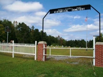
Peace & Goodwill Cemetery is Coosa County's first African American Cemetery to be placed on the prestigious Alabama Historic Cemetery Register. It provides powerful insights about the diligence and commitment of our African Ancestors. Family . . . — — Map (db m64587) HM
Andalusia becomes the County Seat
The first county seat on the banks south of the falls of the
Conecuh River was "Covington Courthouse," sited soon after the
County was created in 1821. In 1826, when John Devereux was
postmaster, the name . . . — — Map (db m283903) HM
Old courthouse clock bell from 1897 to 1917
has been donated to Covington County
this Bicentennial year 1976
by H. Speller Moates and family.
Dedicated to the early settlers of Covington County
Erected in honor of
the . . . — — Map (db m94205) HM
The name Florala came from combining the names of Florida and Alabama. Lake Jackson, located in Florala, is the state's largest natural lake. It is named for Andrew Jackson, who in 1818 camped on the lake with his soldiers while en route to . . . — — Map (db m83457) HM
On December 18, 1821, the Alabama General Assembly appointed Covington County commissioners William Carter Jr., James R. Mobley, Aaron Lockhart, Henry Jones, and Abel Polk “to fix and designate a suitable place for a seat of Justice, and to contract . . . — — Map (db m42549) HM
Side 1
Sanford first came into being as a community post office which was established on May 19, 1879. Around the turn of the century, Sanford had a period of progress that lasted for several years. The L&N Railroad had come through in . . . — — Map (db m94166) HM
Born in South Carolina and orphaned as a young child,
Daniel Dozier arrived in Alabama around 1817. As an adult,
he operated a large farm and grist mill and served as minister
for several area churches. He was a moderator and leader in
the . . . — — Map (db m115007) HM
The area known as Sports was settled by Jonathan Sport and his son, William, who migrated from South Carolina in 1842. Jonathan and William owned 600 acres of land in the area at one time, farming and operating a grist mill. William’s sons John . . . — — Map (db m42825) HM
The historic properties within the Luverne Historic District represent seventy years of history from the 1880s to the late 1940s. This district includes the first commercial businesses in downtown and middle to upper middle-class homes. These . . . — — Map (db m172462) HM
The town of Petrey was named for the family of George Petrey and his
first wife Martha Ann Blackwater, who settled in the area around 1850
after traveling from the Carolinas. The town was originally called
Forkland, but was renamed in honor of . . . — — Map (db m271052) HM
Rutledge was the first county seat of Crenshaw County and held that position from March 1867 to May 1893. Originally called Barber’s Cross Roads, it was briefly named Crenshaw; but June 10, 1867, it was changed to Rutledge in honor of Captain . . . — — Map (db m72053) HM
Located in the Berlin community of Cullman, the Berlin/Kritner Cemetery is the burial place of many early residents. John T. Warren established what became known as Warren Cemetery, originally to serve as the resting place for victims of . . . — — Map (db m290709) HM
“Die Deutsche Kolonie Von Nord Alabama” (The German Colony of North Alabama) lies south of Highway 278E and consists of 27 blocks containing 135 buildings representing various types of historic architecture. The . . . — — Map (db m33837) HM
Col. John G. Cullmann
July 2, 1823 - December 3, 1895
Thrifty German Colonists led by Col. John G. Cullmann in 1873 settled this thinly populated plateau of Alabama.
— — Map (db m35629) HM
The city of Cullman is the county seat of Cullman County, which had scattered settlers as early as 1823. Called "The Crossroads of the True South," Cullman was founded by Col. Johann Gottfried Cullmann. After fleeing his German homeland and living . . . — — Map (db m66397) HM
The first church in the City of Cullman was established on this block of land donated by the North and South Railroad in February 1874. Lots 154, 155, and 181 were granted to Henry Dietz, August Henning, and George Stoback as trustees of the . . . — — Map (db m33841) HM
Born Frankwetler, Bavarta, Germany July 2, 1823
Died Cullman, Alabama December 3, 1895
Colonel Cullmann Founded the City of Cullman, Alabama, in 1873.
Later, in 1877, he founded Cullman County. He also established the Alabama Towns of Bangor, . . . — — Map (db m83459) HM
The first family to settle this area in 1832. Married Nancy Stewart Hanby, daughter of Gabriel Hanby, who was one of the original framers of the Alabama Constitution. They became parents of 11 children: 4 sons served in the Confederate Army. At one . . . — — Map (db m201371) HM
Thrifty German colonists, led by Col. John G. Cullman, in 1873 settled this thinly populated plateau.
This section, previously thought unproductive, became famous for its diversified crops. — — Map (db m29976) HM
The first church at the town site of Cullman. Founded May 1, 1874, at the beginning of the second year of settlement.
An ethnic German church formed by immigrant families. Services held exclusively in the German language until 1932. In 1937, . . . — — Map (db m33840) HM
Preservation of this Weiss Cottage was initiated by the Cullman County Historical Society and implemented by the Cullman County Federation of Women’s Clubs, City of Cullman Bicentennial Commission and the City of Cullman Community Development . . . — — Map (db m33836) HM
Side 1
Old Indian trails leading to the Mulberry River were still fresh when a few dirt farmers began to settle just west of what is now Hanceville. From the beginning a steady stream of settlers, many of whom were German and Irish . . . — — Map (db m156413) HM
Thomas Monroe Corbin and his wife, Ella, settled here in 1894 on 80 acres and built a home. As pioneers, they cleared the ground with crosscut saws, draft horses, double-bit axes, and shovels. Rocks from the field, removed with a horse-drawn slide, . . . — — Map (db m160656) HM
Early settlers to Cullman County established Shady Grove Methodist Episcopal Church as a brush arbor in the 1870s on land homesteaded and donated by Richard McCain. Trustees, J. J. McKissack, W. H. Martin, J. C. Vickery, J. W. Kilgo, together with . . . — — Map (db m34244) HM
Born in Houston County, Georgia, Civil War veteran, farmer, merchant and civil leader, founder of Dean Station, 1888, the beginning of Township of Charlton which was later united with Ariosto
and named Ariton, donor of land for first school . . . — — Map (db m289264) HM
Side 1
Double-pen split log cabin built in 1840's by early settlers who fled disease carrying mosquitoes along Claybank Creek, the first permanent location in this area. This house was the gathering place for many families. The logs tell . . . — — Map (db m74202) HM
Daleville, originally called Dale, was the county seat of Dale County from 1831-1841. William Harper was probate judge of Dale County, which was originally included in present-day Coffee County until 1841, present-day Geneva County until 1868, and . . . — — Map (db m41145) HM
At the request of community residents James A. Waters Sr., Jesse C. Thomas and William C. Grantham, the Town of Level Plains, population 133, was granted incorporation by the Honorable S. Kirke Adams, Dale County Judge of Probate, on April 30, . . . — — Map (db m74187) HM
Richmond - First County Seat
Henry County
Henry County was created December 13, 1819; David Caldwell first Probate Judge, held court in homes of early settlers. Richmond was selected in 1822 for first county seat. Creation of Dale . . . — — Map (db m71585) HM
The Block House 1814
The first public structure in what later became Dale County was erected one mile east of this marker at the confluence of the East and West Choctawhatchee Rivers. Called the Block House, it was built of logs by a contingent . . . — — Map (db m64863) HM
Town on the Hill - 1843. Newton was hub of Dale County activities from 1843 until 1870. During War Between the States (1861-1865), Newton was center of recruiting, including the Home Guards. In March 1865, local militia repulsed attack by . . . — — Map (db m242761) HM
150 yds. west. The first house, built of round logs, with wooden pegs for nails, dirt floor and puncheon seats, was replaced by the present building in 1852. Used for a voting place, a school, and a church.
Originally non-denominational, it . . . — — Map (db m213369) HM
Restored to its original pioneer condition in 1980 by descendants of
William A. "Billy" Byrd
1850-1931
and wife Ophelia Dowling Byrd
1854-1931
This is to certify that Claybank Log Church which has been selected as a landmark . . . — — Map (db m213406) HM
Early Ozark
From 1824, when Dale County was created by an act of the Alabama Legislature, until 1870, the area now comprising the “City of Ozark” was gradually settled mostly by farmers who came and bought the former Indian lands from the U.S. . . . — — Map (db m65250) HM
Side A In the 1820's pioneers, including John Merrick, began settling in vicinity of present-day Ozark, first called "Merrick's". Dale County formed December 22, 1824. In the 1830's wooden stores and cotton gin were built about one mile north . . . — — Map (db m36509) HM
Sam Dale (1772-1841) - Indian trader / wagoner Scout and trader, he explored Alabama wilderness, was called Big Sam "Tholocco" by the Indians later led settlers from Georgia to lands in Tombigbee Alabama River basins.
Gen. Sam Dale Indian . . . — — Map (db m220901) HM
In 1833 A.D. Elias Snell and wife received the God given forsight which led them to give this quarter section of land for the establishment of Asbury Methodist Church — — Map (db m204954) HM
Site of Alabama's first permanent capital 1820-26. County seat Dallas County, 1820-66. Prison for Union soldiers during the War Between the States 1863-65. Indians were the first inhabitants over 4000 years ago. Their large fortified village could . . . — — Map (db m75779) HM
Home site of the author of "Memories of Old Cahaba," whose family lived here from the Capital's earliest days as landowners and lawyers, giving her a rich legacy of town history. Married to a doctor, she moved to Galveston, Texas, and returned here . . . — — Map (db m112360) HM
This stone marks the site of Cahaba, selected November 21, 1818 as the first permanent capital of Alabama, the seat of government remaining here until removed to Tuscaloosa by the Legislature, January 1825.
On December 13, 1819, it was fixed . . . — — Map (db m266506) HM
Two Ghost Towns?
Long before Cahawba was built as
Alabama's first state capital, there was
another village at this location. Just like
Cahawba, it thrived for about 50 years,
then disappeared.
About the year 1500 a group of . . . — — Map (db m112450) HM
In 1818, Alabama's first governor
carved the capital city of Cahawba
out of the wilderness. In less than 50
years, Cahawba grew from a frontier
capital full of log cabins to one of
America's wealthiest communities,
with some of the . . . — — Map (db m112690) HM
This cellar was under Joseph Babcock's brick store. During the Civil War the building was used as a commissary.
Babcock's warehouse and cotton shed were located to your right on the bluff overlooking the river. The family home, kitchen, and . . . — — Map (db m23287) HM
On a May afternoon in 1856, an angry
John A. Bell rounded this corner
carrying a large hickory stick. He passed
by Edward Perine's fine brick store, and
continued south down the sidewalk.
Under his coat, he carried two pistols
and a . . . — — Map (db m112527) HM
The Drug Store
This hole was once the cellar beneath a
drug store operated by Herbert Hudson
& James D. Craig. They sold medicines,
chemicals, paints, perfumes, and cigars.
On the same lot was Thomas L. Craig's
large family . . . — — Map (db m150849) HM
St. Luke's Episcopal Church was built at Cahawba in 1854 but was dismantled and moved sometime after 1884 but before 1888. It was reassembled fifteen miles away in a rural community called Martin's Station. The raised outline before you indicates . . . — — Map (db m83510) HM
In 1866, shortly after the Civil War and a severe flood, the county seat was moved from Cahaba to Selma. Residents rapidly abandoned the town. Many homes were dismantled and reassembled elsewhere.
Despite this trend, returning Confederate . . . — — Map (db m83516) HM
These ruins were once a place of worship for members of the Methodist Episcopal Church South. Built in 1849, it was the first single denomination church in Cahawba. An earlier church for the common use of all denominations was erected about 1840. . . . — — Map (db m112410) HM
"We by-and-by discovered...a pair of those
splendid birds, the Ivory-billed Woodpeckers
(Picus principalis). They were engaged in
rapping some tall dead pines, in a dense part of
the forest, which rang with their loud notes." . . . — — Map (db m112801) HM
Burials in this cemetery, which served Cahaba from 1848 to 1900, tell a story of the town in which many deaths resulted from diseases of infancy, childhood and early adult life, Yellow Fever being a large factor because of proximity to Gulf of . . . — — Map (db m23322) HM
This site was set aside by the 1820 General Assembly, burials here date from 1818 to 1847. Interred are some of the state's earliest figures. There is no record of names, many handsome tombs have been destroyed, seven marked ones remaining, six are . . . — — Map (db m23355) HM
This artesian well was drilled to serve a factory which did not materialize. It was then used to water the grounds, a garden and pastures. In addition, by forcing water through pipes into his $50,000 home, E. M. Perine, a merchant prince, had the . . . — — Map (db m83518) HM
In the late 1850s, Cahaba experienced a building boom. Everyone expected the town to prosper because of the new railroad. One of the first large brick structures built in this prosperous period was completed in 1856 by Dr. Saltmarsh.
He . . . — — Map (db m23009) HM
In the late 1850s, Cahawba experienced
a building boom. Everyone expected
the town to prosper because of the new
railroad.
One of the first structures built during
this prosperous period was completed on
this corner in 1856 by Dr. . . . — — Map (db m150847) HM
This structure collapsed in 1833 and its fallen remains were reportedly heaped into a railroad embankment. Consequently, we have no picture of the Statehouse that was drawn by someone who actually saw the building. Any modern picture you see of this . . . — — Map (db m75909) HM
St. Luke's was consecrated in 1854. It was an outstanding example of the Gothic Revival style, popular at the time. The contractor closely followed designs in a widely circulated book, Rural Architecture, published in 1852 by the celebrated . . . — — Map (db m75922) HM
The Crocherons were from Staten Island, New York. Richard Conner Crocheron arrived in town about 1837 to help run the family store. He traveled north for his bride in 1843 after building her this brick home. The back wall adjoined the brick store . . . — — Map (db m22870) HM
Look around you. There are hundreds of pecan trees growing nearby. All were planted by Clifton Kirkpatrick, a.k.a. The Duke of Cahaba." (Note: Cahawba lost its "w" by the late 19th century.)
In 1889 Samuel and Sarah Kirkpatrick moved to . . . — — Map (db m112473) HM
1822 - Crocheron's Row
Cahawba's First Shopping Center
This large hole was dug in 1822 to be the
basement beneath Cahawba's first brick
store.
In the 19th century the word "row"
described a building that consisted of . . . — — Map (db m112577) HM
Between AD 1500 and 1600, the
indigenous inhabitants of the area around
the confluence of the Cahaba and
Alabama Rivers built a flat-topped mound
measuring about ½ acre in size. The
mound was the central feature of a
semicircular village . . . — — Map (db m150834) HM
By 1858 many brick stores had been built in Cahaba, so everyone called this the "old brick store." Merchant Sam M. Hill turned the building into one huge dry goods store where shoppers could buy just about anything!
Col. Hill, like most of the . . . — — Map (db m23242) HM
Vine Street was Cahawba's business district. Stores, offices and hotels were tightly packed together along these three blocks. Homes were scattered over an entire square mile. Nearly every house had a yard of one or two acres. — — Map (db m83520) HM
Cahawba's homes were spread over an
entire square mile, many with yards of
one or two acres. That was not the case
here on Vine Street. Offices, stores and
hotels were tightly packed along this
main street. The steamboat landings on
the . . . — — Map (db m112560) HM
Offices, stores and hotels were tightly
packed along this main street. The
steamboat landings on the Alabama
River were just one block away, so this
was prime real estate.
Vine Street was 80 feet wide with brick
sidewalks. A town . . . — — Map (db m274486) HM
Abandoned
Thousands of people once called Cahaba
home. Hundreds of fine homes, hotels,
churches, and businesses lined the streets.
Then came the Civil War (1861-1865).
No battle was fought here, but many
of the men that marched . . . — — Map (db m274732) HM
This house, the Fambro / Arthur home,
takes its name from two of its owners.
One was a judge, the other was a former
slave.
The Fambro Family
A. Judge W. W. Fambro built this house
in the early 1840s. He may have created . . . — — Map (db m112451) HM
Walnut Street was the working
backside of the business district.
Cahaba's mechanics and enslaved
laborers knew this street well. It was a
place of livery stables, harness makers,
carriage makers, and blacksmiths. It
was a smelly, dirty . . . — — Map (db m150850) HM
James Franklin Orr founded Orrville in 1842 after arriving in the
area with his father. Originally named Orr's Mill, Orr set about the
slow task of acquiring adjacent lots to build his new town. Orr first
purchased 88 acres and he planned the . . . — — Map (db m244894) HM
Once a gracious turn-of-the-century neighborhood, many of the homes here were close to condemnation when purchased by Circle “S” Industries, Inc. in 1980. In all, 12 Victorian cottages were renovated in the area.
Built between 1870 . . . — — Map (db m37651) HM
In 1952, the City of Selma accepted federal funds to build the George Washington Carver Homes Projects. The residences became “The Face of the Civil Rights Movement” to many in the 1960s because Dr. King, the Southern Christian Leadership Conference . . . — — Map (db m112354) HM
Highlights of Selma History
Dallas County was created by Territorial Legislature Feb. 9, 1818. Selma Land Company formed Mar. 19, 1819 by George Phillips, William Rufus King, Jesse Beene, Gilbert Shearer and Caleb Tate. Selma incorporated . . . — — Map (db m37679) HM
The earliest Jewish settlers came to Selma prior to the Civil War, some as early as the 1830’s. A group of Jewish citizens assembled as the Mishkan Israel Congregation and began meeting in private homes in 1867. The congregation was formally . . . — — Map (db m37677) HM
Native Sampson County, North Carolina.
Admitted to bar, 1806.
North Carolina House of Commons 1807-1809.
U.S. Congressman 1811-16.
Secretary U.S. Legation Naples and St. Petersburg 1816-1818.
Moved to Dallas County, Alabama, 1818.
. . . — — Map (db m37654) HM
Summerfield Summerfield was established in 1819 as Valley Creek and was renamed Summerfield in 1845 to honor the famous Methodist preacher John Summerfield. In 1829, the first academy in Dallas County was chartered in Valley Creek. In 1842, the . . . — — Map (db m217204) HM
Valley Grande developed around a cotton plantation owned by settller George Phillips, who was granted the land in 1821. His log cabin home, which he called Grande View, served as a stagecoach stop, but was burned to the ground by Wilson's Raiders. . . . — — Map (db m297116) HM
Listed on the National Register of Historic Places in February 2006, the district includes 117 commercial and residential properties dating from around 1875 to 1950. The district lies along and adjacent to Grand Avenue, South Valley Avenue and Main . . . — — Map (db m62367) HM
Collinsville burned twice. On December 24, 1884, the Collinsville Depot, Hall-Mackey Store and other businesses were destroyed. Flames again swept the town on February 2, 1900, damaging and destroying businesses and homes including: B.A. Nowlin . . . — — Map (db m62377) HM
Cherokee Indians first inhabited this mound site, subsequently settled by A.H. Lamar, a captain in the Seminole War and first constable (1836) of DeKalb County. Lamar and his Cherokee wife operated trading post and stage coach stop on site, selling . . . — — Map (db m62366) HM
(front)
Crossville, once known as a little village, was named by James A. Copeland because of the area’s many crossroads. In the mid-1800s, mail was brought through Crossville from Rome, GA and Guntersville, AL by stagecoach. The first . . . — — Map (db m79904) HM
This district contains the best concentration of late 19th and
early 20th century middle-class residences built during Fort Payne's
coal and iron industry boom (1888-1891) and the hosiery mill
industry boom (1909-1938).
Laid out in a grid . . . — — Map (db m279144) HM
Little River Canyon has been attracting humans for over 10,000 years. Ancestors of the American Indians came here to hunt, gather fruits and nuts, and create temporary settlements. In 1540 Hernando DeSoto and his army of Spanish soldiers passed . . . — — Map (db m196858) HM
Lebanon Courthouse was constructed during the 1840s when Lebanon, the county seat of
DeKalb County, was a thriving community with inns, taverns, and government offices. This building, built for courthouse use, remained in use as a courthouse until . . . — — Map (db m156255) HM
(front)
No one knows for sure how Geraldine got its name. Some say it was named for a lovely Indian maiden. The first official record was on September 5, 1882 when Mr. William A. Johnson applied for the location of a new post office. The . . . — — Map (db m79905) HM
Front:
The first Lookout Mountain settlers arrived shortly after the Cherokee Indian removal of 1838-1839. These pioneers had been too late for homesteading the good farmland in northwest Georgia. They now turned their attention to Lookout . . . — — Map (db m83688) HM
A Cherokee town founded 1770. Situated on Big Wills Creek, named for a half-breed chief, Red-Headed Will. A place of importance in the Cherokee Territory, it was the home of Sequoyah, inventor of the Cherokee Alphabet; John Ross, the last chief of . . . — — Map (db m213367) HM
Thriving iron ore and coal mining community of early 1900’s established by Colonel John Gordon Battelle five miles north of Valley Head. — — Map (db m61018) HM
Memorial dedicated to
the memory of
David Franklin Foreman
Harriet Bell Wilson Foreman
They deeded this land to the
Coosa River Community to build
two churches and a school house.
Date deeded Sept. 15, 1903
Marker erected by their . . . — — Map (db m225568) HM
Side 1:
Clear, bubbling springs have enticed people to this vicinity for thousands of years. Native American hunting paths led to them and after the defeat of the Creek Indians by the United States in 1813, old trails became the Jackson and . . . — — Map (db m71177) HM
Tukabatchee
On this bend of the Tallapoosa River, stretching out before you, lay one of the ancient towns of the Muscogee Creek People, called Tukabatchee. Tukabatchee is one of the original four mother towns of the Creek . . . — — Map (db m92945) HM
William Bartram, America’s first native born artist-naturalist, passed through Elmore County during the Revolutionary era, making the first scientific notations of its flora, fauna and inhabitants. In 1776 the appointed botanist of Britain’s King . . . — — Map (db m69431) HM
Here stood
Fort Toulouse
A defense against
the Indians
Built by
Bienville
1714
The Alabama Society
of Colonial Dames
preserves the memory
of faithful service
1912 — — Map (db m69567) HM
Here lived Lachlan Mc Gillivray, a Scotch trader among the Indians. His wife, Sehoy, was the daughter of the French Captain, Marchand and Sehoy of the Creek Tribe of the Wind. Here was born their son, General Alexander McGillivray, who went in 1790 . . . — — Map (db m242547) HM
This earthen mound and an adjacent
village were built by people of the
Mississippian culture who likely had
some relationship to the major mound
center at Moundville near present-day
Tuscaloosa. The Mississippian culture is
believed to have . . . — — Map (db m145084) HM
The land area which now comprises the City of Wetumpka was inhabited by various Indian cultures prior to the inward migration of the white man at the turn of the 19th century. The largest Indian village near here was located on . . . — — Map (db m67936) HM
Dixon Home Place
Four generations of Dixons, each promoting the management of trees as a renewable resource, made their living in forestry on this ground thereby contributing significantly to Alabama’s economy and forest industry. . . . — — Map (db m130670) HM
Settled by A.J. Hall in 1852 and occupied by Confederate troops because of its value as a railroad stop during the War Between the States (1861-65), Canoe was the site of a March 27, 1865 encampment of Union forces. The 1870s brought expansion . . . — — Map (db m72265) HM
Williams Station, Alabama
1866-1897
Creek Indians lived in these parts some 200 years before trains began stopping here in 1866 to leave supplies for a farmer, William Larkin Williams, who lived nearby. Workers, who came first to build . . . — — Map (db m154553) HM
Damascus Travelers Well (construction date unknown) was originally a public water well offering refreshment and rest for travelers and their animals passing through this area. The Damascus community also benefited from this well. Mr. and Mrs. N. W. . . . — — Map (db m130668) HM
Front As railroads were reconstructed following the Civil War, a junction of north-south and east-west lines was established along the Alabama-Florida border near the confluence of Big Escambia Creek and the Conecuh-Escambia River. A . . . — — Map (db m47484) HM
Coley Chapel is the present day site of the former Town of Hadley.
MacDavid's Hotel was also located here and was recorded by travelers in the 1830's as a hotel which had "plenty of nice pork, which in some shape or other is the food generally . . . — — Map (db m84376) HM
41683 entries matched your criteria. Entries 201 through 300 are listed above. ⊲ Previous 100 — Next 100 ⊳