By Mark Hilton, May 26, 2017
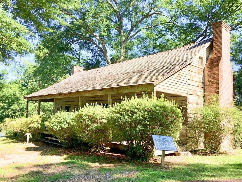
Scotia "Dog Trot" log house.
| Near Grand Gulf Road east of River Road. |
| On Grand Gulf Road, 1.1 miles north of Frazier Road, on the left when traveling north. |
| Near Unamed Road, 0.7 miles west of Natchez Trace Parkway, on the right when traveling west. |
| Near Natchez Trace Parkway (at milepost 54.8). |
| On Church Street (U.S. 61) south of Carroll Street, on the right when traveling south. |
| On Old Mill Road, 0.4 miles south of Bald Hill Road, on the right when traveling south. |
| On Church Street (U.S. 61) near Horton Street, on the right when traveling north. |
| Near Church Street south of Horton Drive, on the right when traveling north. |
| Near Church Street (U.S. 61) near Horton Drive, on the right when traveling north. |
| On Church Street (U.S. 61) south of Chinquepin Street, on the right when traveling south. |
| On Church Strery (U.S. 61) north of Oak Street, on the right when traveling north. |
| On Church Street (U.S. 61) at Walnut Street on Church Street. |
| On Church Street (U.S. 61) near Horton Drive, on the right when traveling north. |
| Near Shaifer Road, 1.5 miles west of Bessie Weathers Road, on the right when traveling west. |
| On Church Street (U.S. 61) near Horton Street. |
| On Horton Drive north of Brady Avenue, on the right when traveling south. |
| On Rodney Road, 1.6 miles west of Montgomery Road, on the left when traveling west. |
| Near Rodney Road (State Highway 552) 1.3 miles north of Rodney Westside Road, on the right when traveling north. |
| On Gunn Drive (U.S. 11) at Old Mill Creek Road, on the right when traveling north on Gunn Drive. |
| On Mississippi Route 47, 0.3 miles west of Pruitt Road, on the right when traveling west. |
| On State Highway 45, on the right when traveling north. |
| On Desoto Avenue (U.S. 49E) at North State Street (U.S. 61), on the right when traveling north on Desoto Avenue. |
| On Sunflower Avenue at 1st Street, on the right when traveling south on Sunflower Avenue. |
| Near Clark Street at Yahoo Avenue. |
| On Coahoma-Rich Road, 0.9 miles south of U.S. 61, on the right when traveling south. |
| On 2nd Street at Church Street, on the left when traveling north on 2nd Street. |
| On 2nd Street at Webb Street, on the left when traveling north on 2nd Street. |
| On West Georgetown Road near West Railroad Street S, on the right when traveling north. |
| On Chautauqua Drive, 0.5 miles west of U.S. 51, on the right when traveling west. |
| On Caldwell Drive (U.S. 51) at West Gallatin Street, in the median on Caldwell Drive. |
| On Eigth Street north of Cemetery Street, on the right when traveling north. |
| On East Railroad Avenue at Hotel Street, on the left when traveling north on East Railroad Avenue. |
| On Lake Mike Connor Road at Yates Road, on the left when traveling south on Lake Mike Connor Road. |
| On U.S. 51 south of West Commerce Street, on the right when traveling south. |
| On Bonhomie Road, 0.2 miles south of W.S.F. Tatum Boulevard, on the left when traveling south. |
| On Hardy Street at East Pine Street (U.S. 11), in the median on Hardy Street. |
| On Hardy Street (U.S. 98) at North 34th Avenue, on the right when traveling west on Hardy Street. |
| On West Pine Street (U.S. 11) at Forrest Street on West Pine Street. |
| On West Front Street (U.S. 11) at Dudley West Conner Street, on the left when traveling west on West Front Street. |
| On U.S. 49, 0.8 miles north of Newton Field Road, in the median. |
| On Macedonia Road at Morriston Road, on the right when traveling north on Macedonia Road. |
| On Sunrise Heights east of Sunrise Road, on the right when traveling east. |
| On Choctaw Road, 5 miles west of Shucktown Road, on the left when traveling west. |
| On Old Avera Road, 0.1 miles south of Kate James Road, on the right when traveling north. |
| On Dr Martin Luther King Jr Boulevard at Sunset Drive (State Route 8), on the right when traveling north on Dr Martin Luther King Jr Boulevard. |
| On South 2nd Street north of City Park Avenue, on the left when traveling north. |
| On Logtown/Possum Walk Trail, 1.5 miles west of State Highway 604, on the right when traveling west. |
| On Logtown/Possum Walk Trail, 1.5 miles west of State Highway 604, on the right when traveling west. |
| On Napoleon Boat Launch Road, 0.7 miles west of Old Napoleon-Westonia Road, on the left when traveling west. |
| On State Highway 607, 1 mile south of Old US Highway 11, on the right when traveling south. |
| On South Beach Boulevard south of Brown Road. |
| On U.S. 90 near Main Street, on the right when traveling east. |
| On Beach Boulevard (U.S. 90) at Bellman Street, on the right when traveling west on Beach Boulevard. |
| Near Porter Avenue at Beach Boulevard (Highway 90). |
| On Main Street. at Beach Boulevard (U.S. 90), on the right when traveling south on Main Street.. |
| On Bayview Avenue, 0.5 miles Interstate 110, on the right when traveling west. |
| Near Beach Boulevard at Porter Avenue, on the right when traveling west. |
| Near Beach Boulevard (U.S. 90) at Porter Avenue. |
| Near Porter Avenue near Beach Boulevard (Highway 90). |
| Near Church Avenue at Gorenflo Road, on the right when traveling south. |
| On Bay Shore Drive at Boney Avenue, on the left when traveling west on Bay Shore Drive. |
| On Santa Cruz Avenue at Bay Shore Drive, on the right when traveling south on Santa Cruz Avenue. |
| On Race Track Road at Central Avenue, on the right when traveling west on Race Track Road. |
| On Central Avenue at West Race Track Road, on the right when traveling south on Central Avenue. |
| On East Pass Road at Monet Street, on the right when traveling east on East Pass Road. Reported damaged. |
| On Rippy Road at Creosote Road, on the right when traveling east on Rippy Road. |
| On Three Rivers Road at Rippy Road, on the right when traveling north on Three Rivers Road. Reported missing. |
| Near Friendship Oak Circle west of Beach Park Place, on the right when traveling west. |
| On Jeff Davis Avenue at East 2nd Street, on the right when traveling north on Jeff Davis Avenue. |
| On Beach Boulevard East (U.S. 90) 0.1 miles west of East Azalea Drive, on the right when traveling west. |
| On Beach Boulevard East (U.S. 90) at Gulf View Avenue, on the right when traveling east on Beach Boulevard East. |
| On East Scenic Drive, 0.1 miles west of Menge Avenue. |
| On East Scenic Drive, 0.1 miles west of Davis Avenue, on the right when traveling west. |
| Near West College Street at Jefferson Street. |
| On Clinton Parkway at East Main Street, on the right when traveling north on Clinton Parkway. |
| On Natchez Trace Parkway (at milepost 88.1), 1 mile north of Interstate 20, on the right when traveling north. |
| On Jefferson Street north of Main Street, on the right when traveling north. |
| On Jefferson Street at West Main Street, on the right when traveling south on Jefferson Street. |
| On Lakeland Drive, 0.2 miles east of Interstate 55. |
| Near Lakeland Drive (State Highway 25) at Interstate 55 when traveling north. |
| Near Natchez Trace Parkway (at milepost 93.1), 0.5 miles north of Medgar Evers Boulevard (U.S. 49), on the left when traveling north. |
| Near U.S. 49, 8.8 miles north of Interstate 220, in the median. |
| On North Congress Street north of East Amite Street, on the left when traveling north. |
| On Lakeland Drive, 0.2 miles east of Interstate 55. |
| On Riverside Drive at Peachtree Street, on the left when traveling east on Riverside Drive. |
| On Gillespie Street at North Jefferson Street, on the left when traveling west on Gillespie Street. |
| On St Mary Street at Pinehurst Street, on the right when traveling north on St Mary Street. |
| On John R. Lynch Street at Valley Street, on the right when traveling east on John R. Lynch Street. |
| Near U.S. 49, 0.8 miles south of Kennebrew Road, in the median. |
| Near Highway 49, 0.7 miles south of Kennebrew Road, in the median. |
| On Cunningham Street just west of South Utica Street, on the left when traveling west. |
| On State Highway 27 at State Highway 18, on the right when traveling south on State Highway 27. |
| On North Jackson Street (U.S. 51), on the right when traveling south. |
| On Court Square (Mississippi Route 12/17) south of Oak Street, on the left when traveling south. |
| On Court Square at Wall Street (State Route 17), on the left when traveling east on Court Square. |
| On Martin Luther King Drive (U.S. 49E) at East Main Street, on the right when traveling north on Martin Luther King Drive. |
| On Mississippi Route 7 north of Fishco Road, on the left when traveling north. |
| On East Owens Street east of South Rose Street, on the right when traveling east. |
| On West Main Street at South Cummings Street, on the left when traveling west on West Main Street. |
| On East Main Street, 0.1 miles east of South Rose Street, on the right when traveling east. |
396 entries matched your criteria. Entries 101 through 200 are listed above.
⊲ Previous 100 —
Next 100 ⊳