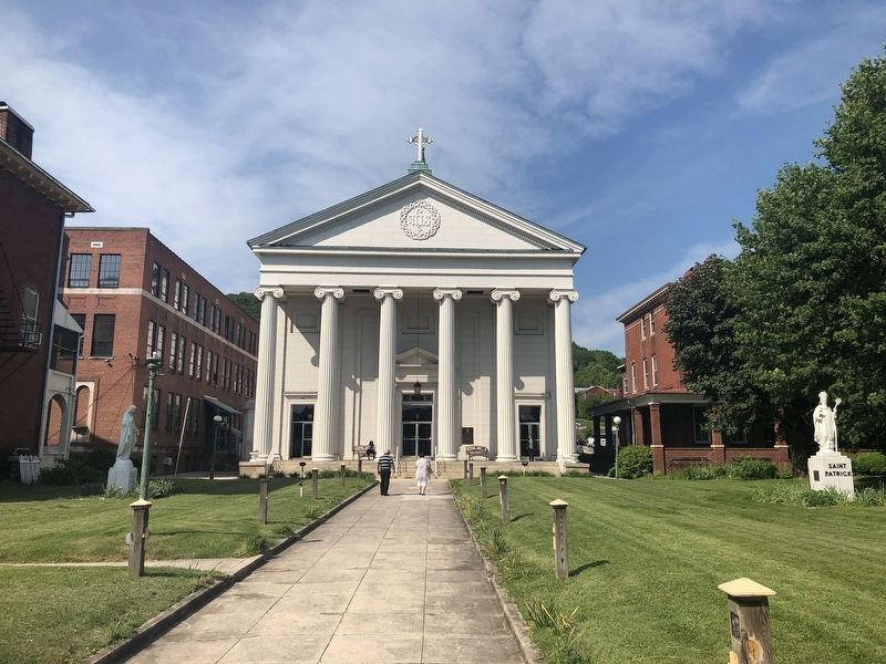
The Cumberland Roman Catholic Parish was established in 1790 by Father Dennis Cahill, a missionary working in Western Maryland. A log church dedicated to Mary the Mother of God was soon erected in 1791 at the front of the parish property. . . . — — Map (db m134395) HM
A log chapel dedicated to St. Mary was built on this site in 1791. The first parishioners were mostly English Catholics from Southern Maryland. A brick church replaced the log building in 1939. Cumberland became a major center of transportation and . . . — — Map (db m134394) HM
We the people of the United States, in order to form a more perfect Union, establish justice, insure domestic tranquility, provide for the common defence, promote the general welfare, and secure the blessings of liberty to
ourselves and our . . . — — Map (db m176348) HM
Downtown
The Downtown Cumberland Mall is the main shopping and dining district for the city. The brick street is lined with large multi-story commercial buildings, which were built in the late 19th and early 20th centuries. These buildings . . . — — Map (db m139110) HM
Downtown Cumberland
The Flood of March 29, 1924 inflicted almost $5 million worth of destruction in the City of Cumberland. Telephone, telegraph, roads and electric wires were washed away. Though not as bad, another flood occurred on May 12th . . . — — Map (db m139111) HM
In 1749 Christopher Gist, an agent for the Ohio Company, arrived at the junction of the Wills Creek and the North Branch of the Potomac River to erect a trading post. In anticipation of the French and Indian War a fort was constructed in 1754 . . . — — Map (db m139113) HM
Horatio Sharpe Lived: 1718-1790. Here as Governor of Maryland and the commander of the fort. Fort Frederick was built by his direction. Governor: 1753-1769. Sharpsburg, Md., was named in his honor. Daniel Boone Lived: 1734-1820. Here as a . . . — — Map (db m17681) HM
Fort Cumberland grew out of the efforts of The Ohio Company to speculate in land and establish a fur trade with the Indians between here and the Ohio Valley and the efforts of the British government to enforce land claims in these areas.
The . . . — — Map (db m139107) HM
The land west of the Allegheny Mountains was exclusively the Indians until the mid 1700's. The local Indians were part of the Shawanese tribe and a sub-division of the Algonquin Nation-one of the most warlike. With the coming of the white man, . . . — — Map (db m167128) HM
This great water - gap was discovered in 1755 by Lt. Spendelow, a naval officer with the ill - fated Braddock expedition. Cut by the stream now known as Wills Creek, widened by ages of frost and rain, and plunging down over 900 feet from the top of . . . — — Map (db m174246) HM
Built by Old German Lutherians
now owned by
First Christian Congregation
Clock awarded by town in contest
National Register of Historic Places — — Map (db m219219) HM
This site is believed to be the homesite and final resting place of Mr. Evart (Evitt) who, reportedly, was the first white settler in Allegany County.
He came here in the early 1700's to escape civilization and live as a hermit.
The . . . — — Map (db m95688) HM
Years before St. Michael’s Church was built,
Meshach Frost and his wife Catherine purchased
this property in 1812. When the Frosts bought the
property, construction of the National Road was
already underway. They soon found they were
feeding . . . — — Map (db m3551) HM
Frostburg can trace its history back to the very early 1800s, when the community was known as Mt. Pleasant and consisted of only three homes. By the time the National Road opened through in 1812, an early settler named Josiah Frost had lain off the . . . — — Map (db m96388) HM
Established: 1812
Elevation: 1820'
Population: 9,002
County: Allegany
Situated in the headwaters of the Georges Creek basin, Frostburg was settled in the early 1800's and served as a traveler's stop along the newly constructed National . . . — — Map (db m96390) HM
Years before St. Michael's Church was built, Meshach Frost and his wife Catherine purchased this property in 1812. When the Frosts bought the property, construction of the National Road was already underway. They soon found they were feeding and . . . — — Map (db m199913) HM
During colonial exploration and settlement the valley provided a route to the western frontier. In 1753, preceding the French and Indian War, George Washington traveled this route to deliver Gov. Dinwiddie's order that the French abandon their . . . — — Map (db m84736) HM
Near this spot, a vibrant African American neighborhood existed prior to the construction of the Frostburg State University campus.
The name and spirit of Brownsville emerged in the late 19th century largely due to the courage and dedication . . . — — Map (db m199904) HM
Contrary to popular belief that it was named for its frigid winter weather, Frostburg can trace its history back to 1800 when the community was known as Mt. Pleasant. By the time the National Road (authorized by Congress in 1806) opened through in . . . — — Map (db m167992) HM
A trolley car and horse and buggy descend the old National Road at Eckhart Hill, just east of Frostburg. In 1806 construction of the Cumberland (National) Road was authorized by Congress. Its purpose was to connect the populated east and "navigable . . . — — Map (db m96383) HM
The Clarysville Inn once stood in front of you to the right. In this tavern, and in a complex of buildings constructed around it, the United States established a general hospital during the Civil War. On March 6, 1862, U.S. soldiers commandeered . . . — — Map (db m37540) HM
The Potomac River meanders through six miles of bends here with steep cliffs dropping to the river, making the digging of a ditch canal nearly impossible. The canal company could have followed a natural fold (1) in the rock stratification to . . . — — Map (db m140022) HM
Dedicated to
the pioneers who
with heroic sacrifice
and undaunted courage
blazed this old trail
now known as
the National Highway
and thus opened
"The Gateway to the West" — — Map (db m199894) HM
Daniel Cresap, pioneer settler, gave his name to Dan's Mountain and Dan's Rock. Born in 1728 near Havre de Grace, MD., son of Colonel Thomas Cresap. Fought in French and Indian War. By first wife, unknown, had one son; by second wife, Ruth . . . — — Map (db m98538) HM
Founded in 1837 by the Georges Creek Coal and Iron Company, Lonaconing has endured its share of disasters. On September 7, 1881, a devastating fire wiped out the entire business district. Although the town rebuilt, the community suffered through . . . — — Map (db m139064) HM
Robert Twigg was the first Twigg to acquire land in what is now Allegany County, Maryland. In 1768 he purchased this land known as "Sink Hole Bottom". On this site, Austin D. Twigg (1863-1941) ran the Twiggtown General Store and Post Office as . . . — — Map (db m144697) HM
1694 - 1790
Pathfinder - Pioneer- Patriot
Founder of Oldtown about 1740
Surveyed first trail west 1751
Led in defense of settlers against hostile indians
Served in Provincial Assembly
Active in Sons of Liberty and
Committee of Safety . . . — — Map (db m177112) HM
He built his house, which can be seen nearby, about 1764. A trader, he cleared wilderness and fought Indians in “Cresap’s War” in Ohio, 1774. As a Captain he led riflemen, some painted Indian-style, to Boston at the start of the . . . — — Map (db m448) HM
The basin before you, above Lock 70, provided a landing for canal boats. A general store was built adjoining the original lockhouse. Across the lock a feed store was built. Boatmen could leave the hustle and bustle of Cumberland and tie up here to . . . — — Map (db m140010) HM
This site owned by Amos Garrett was surveyed as Lot 46 on James Stoddert's 1718 plan of Annapolis. The Lloyd Dulany family lived here from 1761 until 1783. The group of buildings known successively as Mann's Tavern, City Tavern and the City Hotel . . . — — Map (db m6194) HM
On March 25, 1655, colonial Governor William Stone landed Maryland militia at the Puritan settlement of Providence, located at the mouth of the Severn River. He planned to subdue the settlers who had asserted their independence from the government . . . — — Map (db m53178) HM
Has been designated a Registered National Historic Landmark Under the provisions of the Historic Sites Act of August 21, 1935. This site possesses exceptional value in commemorating or illustrating the history of the United States U.S. . . . — — Map (db m6199) HM
The oldest surviving map of Annapolis, drawn by James Stoddert in 1718, shows that the area now occupied by Corhill and Fleet Streets, had been set aside for Governor Francis Nocholson for use as a garden, summer house and vineyard. In 1771 Charles . . . — — Map (db m17689) HM
The first English settlers were a group of Puritans who established Providence, a settlement at the mouth of the Severn River, in 1649. The Puritans probably used Captain John Smith's Bay map to navigate here from Virginia. Their settlement was not . . . — — Map (db m114869) HM
Look around the harbor. Imagine what the first colonists saw more than 350 years ago when they first viewed this Chesapeake Bay peninsula: a pristine, abundant natural site with deep, protected harbors that had experienced little human settlement. . . . — — Map (db m19266) HM
Francis Street is named for Sir Francis Nicholson (1655-1728), royal governor of Maryland, who served from 1694 to 1698. When the capital of the colony moved from St. Mary's City to Annapolis, Nicholson devised the city's baroque plan featuring two . . . — — Map (db m114797) HM
Bloomsbury Square was named after a square in London where the Lords Baltimore, proprietors (owners) of Maryland, lived and where prospective settlers went in 1633 to get information concerning the proposed new colony of Maryland. Bloomsbury Square . . . — — Map (db m5419) HM
This granite block was dedicated as the cornerstone of a proposed fountain on 22 November 1908, the 200th anniversary of the Annapolis City Charter. The fountain was planned to commemorate the 1649 "Act Concerning Religion," known as the "Act of . . . — — Map (db m6386) HM
During winter 1988/89, the area known as Lot 70 in James Stoddert’s 1718 survey will be the site of a historical archeological excavation.
In 1718, this lot was owned by Charles Carroll, grandfather of Charles Carroll of Carrollton, who in 1734 . . . — — Map (db m2860) HM
From its earliest history until the 1920s, log canoes, merchant sailing ships, workboats, ferry and steam boats, comprised the majority of vessels in these waters. But after local businessmen developed marinas to accommodate pleasure craft, the . . . — — Map (db m19292) HM
Francis Nicholson became governor of the province of Maryland in 1694. He was largely responsible for the relocation of Maryland's capital from St. Mary's City to the more centrally located town on the Severn River that he named Annapolis. In . . . — — Map (db m114551) HM
One of the oldest surviving houses in Annapolis, Shiplap House served as a store and tavern in the eighteenth century. The house is named for the random-width flush siding (called shiplap) on the rear facade and northeast ell. The building now . . . — — Map (db m17690) HM
Sy Mohr's City Dock Harbormaster Collage speaks to the magical landscape that welcomes citizens and visitors alike to the City Dock and the historical City of Annapolis. His work takes us on a trip through time, progressively moving from the past in . . . — — Map (db m114802) HM
Wiley H. Bates was born into slavery on a North Carolina plantation in 1859, attending only three days of schooling in his lifetime. He built a legacy based on hard work and economic success, triumphing in what he called "the race of life." . . . — — Map (db m157087) HM
Built 1774 by Matthias Hammond, local patriot
Designed by William Buckland, Colonial Architect
18th Century furnishings
One of America's famous houses
Open to the public — — Map (db m127929) HM
This is the oldest house in Eastport. For nearly 100 years it belonged to the Williams family.
Jonas and Louisa Williams and their eight children moved here in 1876. They used the first floor as a grocery store, selling homemade sauerkraut . . . — — Map (db m114880) HM
You're looking out across the mouth of the Severn River where it meets the Chesapeake Bay. In the summer of 1608 Captain John Smith sailed within sight of this spot four times during his "voyages of discovery" up and down the Chesapeake Bay. His . . . — — Map (db m114871) HM
1600's
Captain John Smith and the Jamestown Expedition wrote:
Oysters "lay on the ground as thick as stones."
1700's
Chesapeake traveler Francis Louis Michel wrote:
"The abundance of oysters is incredible."
1870-1890 . . . — — Map (db m114862) HM
In 1649, a group of "non-conformist" Puritans landed on the shores of Whitehall Bay, fleeing religious persecution in Virginia and seeking new opportunities in Lord Baltimore's colony of Maryland. These devout Protestants took up land that had been . . . — — Map (db m221301) HM
During Parole's early years, the horse and wagon was a basic means of local transportation and livelihood. Many families sold vegetables from their horse-drawn wagons.
Gardening and farming were the main occupations for Camp Parole . . . — — Map (db m232511) HM
To Edward, Joshua, and John Dorsey, sons of Edward Dorsey who settled in Maryland in 1650. The patent was signed by Charles Calvert, then Lieutenant General, and later Third Lord Baltimore. This plantation has been the homestead of the Dorseys for . . . — — Map (db m2906) HM
The Civil War
The Civil War had a major impact on the people of Anne Arundel County. As a border state, Maryland was home to both Confederate and Union sympathizers. Like Baltimore, Annapolis was occupied by Union troops during the Civil . . . — — Map (db m232510) HM
To honor the three hundredth anniversary of the coming to Maryland circa 1652 of Alexander Magruder, founder and progenitor of the Magruder family in America, and to the men of his blood who have been students at St. John's College. — — Map (db m5417) HM
St. John's College has a long, rich history dating back to the founding of our nation. Its earliest incarnation, a grammar or preparatory school named after King William III, was founded in Annapolis in 1696, one year after Maryland's capital was . . . — — Map (db m63410) HM
The historic buildings you can see from here date back to before 1900, when the first bridge to Annapolis connected to the end of this street. In those days, Fourth Street was the bustling commercial heart of Eastport. Anything you wanted from . . . — — Map (db m114860) HM
Many African-American families settled here more than a century ago. these families, who have lived here for four generations, are the heart and soul of this neighborhood. Their religious, educational and cultural institutions are pillars of . . . — — Map (db m5653) HM
You are standing at the corner of "Murphy's Row." These ten row houses were built in 1888 by Charles James Murphy for laborers employed at his company, the Annapolis Glass Works.
The houses bear witness to Eastport's early years. The seventh . . . — — Map (db m170217) HM
Prestigious sailboat racing events have made Annapolis famous. But the real reason for Annapolis' reputation as "America's Sailing Capital" is the community of Eastport. There are more marine-related businesses here than anywhere on the East Coast . . . — — Map (db m5727) HM
This century-old farmhouse is one of the only reminders of the agrarian past of Eastport. Yet, in the eighteenth and early nineteenth centuries, horse racing and farming were the economic mainstays. As late as 1798, there were only two buildings . . . — — Map (db m170215) HM
This is where Eastport's famed boat building industry began. On this site in 1868, a German immigrant named Wilhelm Heller began crafting fine wooden boats. His reputation spread and business flourished. Heller's became the largest boatyard on Spa . . . — — Map (db m5734) HM
Eastport's distinctive history, character and identity grew from maritime roots. The marinas that now serve pleasure boaters were once filled with wooden workboats. So crowded was the shoreline, it was said that an enterprising cat could flit from . . . — — Map (db m5890) HM
Eastport's distinctive history, character and identity grew from maritime roots. The marinas that now serve pleasure boaters were once filled with wooden workboats. So crowded was the shoreline, it was said that an enterprising cat could flit from . . . — — Map (db m5891) HM
[photo of plants and tools] Early medicinal plants and tools
Colonial Medicine Chest
Where did the colonial doctor or housewife turn when they needed to treat the sick? The plants of the field, hedgerow and marsh were their pharmacy. . . . — — Map (db m22138) HM
Scattered Settlements
Early Chesapeake Bay colonists did not settle in the concentrated villages typical of their home in England. Instead, they lived on large plots of waterfront land that isolated them from their neighbors.
Cheap and . . . — — Map (db m22112) HM
[map of colonial Maryland] Detail from The State of Maryland, Samuel Lewis, 1795. Showing London Town, Annapolis and Baltimore.
Welcome
Historic London Town and Gardens is a 23-acre park where discover and learning are daily . . . — — Map (db m22140) HM
Have you wondered how we know so much about past cultures? Have you ever thought about future generation studying the present? What would they find?
Since no books or photographs were left behind by earlier civilizations to tell us how they lived, . . . — — Map (db m80878) HM
Native American Exhibit 250 yards, a 5 minute walk
Java Plantation Exhibit .5 mile, a 25 minute walk
Java Dairy Exhibits .75 mile, a 55 minute walk
Java’ Return to Nature Exhibits 1 mile, a 70 minute walk
Indians of the Chesapeake For . . . — — Map (db m80874) HM
Has been designated a Registered National Historic Landmark under the provisions of the Historic Sites Act of August 21, 1935. This site possesses exceptional value in commemorating or illustrating the history of the United States. — — Map (db m3420) HM
The ravine in front of you was once Scott Street. Rumney's Tavern, the Brown Carpenter Shop and the Brown House are on this side of the street. On the other side were a number of structures, some of which were commercial enterprises such as . . . — — Map (db m22141) HM
A Transportation Network
Ferries were a critical link in the colonial road system. The ferry crossing at London Town was part of a larger transportation network that extended from Virginia to New York, moving people and goods to market along . . . — — Map (db m22143) HM
[drawing of tenement house]
Lord Mayor's Tenement: An architectural drawing by Willie Graham, Colonial Williamsburg Foundation.
Discovering the Lord Mayor's Tenement
This building has been reconstructed on the footprint of the . . . — — Map (db m22145) HM
Location, Location, Location
One of the mysteries that still surrounds the lost town of London is the William Brown House. Built between 1758 and 1764 overlooking the South River, William Brown intended it to serve as his dwelling and an . . . — — Map (db m22137) HM
Surveyed, 1663, as Holland’s Hills for Francis Holland; bought 1665, by Richard Harrison, Quaker planter and shipowner, who owned about 6,000 acres. The house, built in three stages between 1665 and 1733 by Richard Harrison and his son Samuel, is . . . — — Map (db m2938) HM
Imagine life in the Carrie Weedon house in 1901. Kerosene lamps provided light for reading, sewing, or playing the piano. Water came from an outdoor hand pump. A privy, a small barn, and a shed were located out back. Food was grown in the garden or . . . — — Map (db m6200) HM
Cedar Park
Patented to Richard Ewen in 1666 as “Ewen upon Ewenton.” Brick house built c.1697 by Richard Galloway II around earlier frame structure possibly dating back to 1656. Known as “West River Farm” in 18th Century. . . . — — Map (db m65889) HM
One hundred years ago, Steamboat Landing was the hub of the community. The vessels that docked there linked Galesville to the world. Immigrants and vacationers arrived, while farm produce and seafood were shipped out to Baltimore and other ports. . . . — — Map (db m6203) HM
The members of the Galesville Heritage Society invite you to explore their historic village. First settled in 1654 on the banks of West River, Galesville and its history are fundamentally linked to the Chesapeake Bay. Native Americans, English . . . — — Map (db m6201) HM
600 acres patented in 1664 to Mareen Duval, Esq., great Hugenot and native of France. Appointed Commissioner for Advancement of Trade 1683, he died here 1694. The plantation remained the ancestral seat of a junior branch of the Duvall family for . . . — — Map (db m43527) HM
Freetown is one of the largest and oldest African American communities in Anne Arundel County, founded sixteen years before the start of the Civil War. The founders included free-born Blacks, formerly enslaved persons and run-aways, and indentured . . . — — Map (db m246452) HM
This site was originally settled in 1649 and was known as the Westminster parish. About 1780 it was the property of Francis Cromwell, a cousin of the monarch of England. It was obtained by the Curtis Creek Mining Co. in 1850 from the estate of John . . . — — Map (db m14158) HM
An African American community and church were established nearby in the mid 19th century. In 1918 the Benevolent Sons and Daughters of Abraham, a mutual aid society, purchased and donated land on this site for a two-room school which was built . . . — — Map (db m49729) HM
Charles Lord Baltimore and his council attended the meeting of the Assembly here Oct. 2 – Nov. 6, 1663. 31 towns and ports of entry were established at this session in the several counties along the bay. Practically none of these towns exist . . . — — Map (db m2945) HM
Designed by Frederick Douglass so that "As a free man I could look back across the bay to the land where I was born a slave". Built by Charles Remond Douglass. 1895 — — Map (db m6173) HM
Built circa 1820, the Benson-Hammond House is the headquarters of the Ann Arundell County Historical Society and is open to the public.
Annapolis and Baltimore Short Line
Organized in 1880, the Annapolis and Baltimore Short Line ran its . . . — — Map (db m3161) HM
Growth of railways advanced the development of suburban communities in the early 20th century. Linthicum Heights was platted in 1908 along two interurban railroads by the Linthicum family to take advantage of direct transportation to Washington, . . . — — Map (db m8142) HM
Portland Landing
and
Saint Jerome's
Surveyed 1700
Owned by Col. Henry Darnall
brother-in-law of Charles,
3rd Lord Baltimore and
Secretary of State. — — Map (db m3142) HM
Restoration of the exterior and the interior first floor of this building to represent a typical late 1930s, early 1940s Anne Arundel County farmhouse.
The farmhouse was built around 1925 by Henry Kinder and his wife Hilda (Yanke). The first . . . — — Map (db m99089) HM
Adam Shipley, who came to Anne Arundel County in 1668, on March 30, 1681, patented 200 acres on the south side of the Severn River. Dedicated during the Tercentenary Commemoration of the Shipleys of Maryland. May 25, 1968. — — Map (db m80457) HM
Built around 1925 by Henry Kinder and his wife Hilda (Yanke) would raise their 8 children in this American four square brick home.
This house has served as the heartbeat of the farm for over 50 years and in 1979 Henry Kinder's sons, Edward, . . . — — Map (db m145231) HM
Established in the mid 19th century on land owned by Capt. James Spencer, who served in the Union Army during the Civil War, Freetown illustrates the principles of self-sufficiency and cooperation typical of African American communities. The first . . . — — Map (db m13567) HM
Recorded on the
National Register
of
Historic Places
1975.
Second Marker (inside the facility):
Hancock's Resolution
Unusual for its stone construction, this house was built c1785 by Stephen & Belinda Ridgely Hancock, a . . . — — Map (db m9064) HM
Before the Park (1674-1896)
Native Americans have used this land for more than 5,000 years, leaving behind piles of oyster shell, along with shards of pottery and projectile points from the Lat Archaic (3,750BC-1,250BC) to the Woodland . . . — — Map (db m98465) HM
The Patapsco Park area, widely known as Pumphrey, is an historic African American enclave with roots dating to well before the American Civil War. The largely Black community remained homogeneous for many years and prided itself with . . . — — Map (db m240357) HM
During 2001-2004, Anne Arundel County’s Lost Towns Project conducted excavations in the neighboring community of Leitch in search of the lost town of Herrington (c. 1660), one of Maryland’s earliest legislated port towns. Established by the Maryland . . . — — Map (db m79981) HM
873 entries matched your criteria. The first 100 are listed above. Next 100 ⊳