David Hall, a revolutionary War veteran, purchased a plantation near here in 1803. Seven years later he opened a tavern and inn on the property. Granville Arnold purchased the site in 1854, operating the inn for the remainder of the 19th century. . . . — — Map (db m165936) HM
Although many residents still felt Oak Ridge was a wartime town, they were now encouraged to view their city as possibly becoming a permanent community. This transition was kicked off January 1 when the Manhattan Engineering District handed off . . . — — Map (db m112281) HM
Union Carbide agreed to manage X-10 as well as the Y-12 plant with their new defense mission, and the K-25 uranium enrichment plant. Carbide named Nelson Rucker as X-10 executive director who with Alvin Weinberg instilling a sense of stability as . . . — — Map (db m112282) HM
From April 1, 1943, until March 19, 1949, this was the site of Elza Gate. Elza Gate was the primary entrance to the secret community of Oak Ridge and along with six other entry points, it was manned by armed guards. Elza Gate took its name from a . . . — — Map (db m88625) HM
Centrally located between Jackson Square and Jefferson Center, Grove Center was one of three large commercial areas built for residents of Clinton Engineer Works in need of a place to run everyday errands and escape from the stressful demands of . . . — — Map (db m215323) HM
The Midtown Community Center first opened on February 2, 1945, in support of the World War II Manhattan Project workers and residents. The building's first use was a meeting place and recreation hall for the Middletown area, which included . . . — — Map (db m215324) HM
In 1943, Oak Ridge was created as the residential center for the Clinton Engineering Works. Located on the northeast corner of a 59,000-acre reservation acquired by the government in 1942, the community was designed by Skidmore, Owings, and Merrill, . . . — — Map (db m81358) HM
In November 1942, Army Engineers were ordered to build a town for 13,000 people. A year later their target grew to 42,000, and the actual population reached 75,000 in September 1945 – almost three times the city’s 2005 population. Shown on no . . . — — Map (db m112549) HM
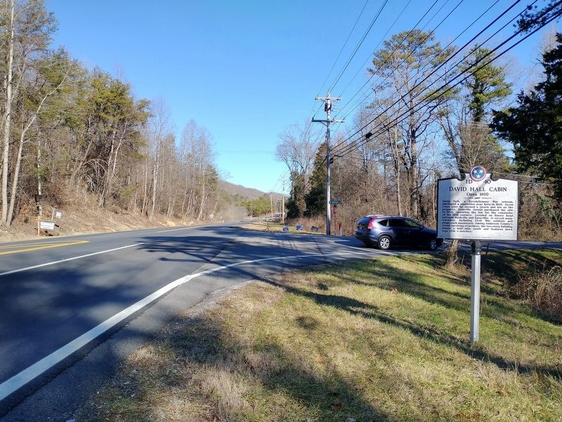
On a route that was first authorized to be "cut and cleared" in 1787, the Rock Pillar Bridge 60 yards to the north-northeast was built in the early 1900's. This road became known as the Emery Road and was one of the earliest routes used in the . . . — — Map (db m89677) HM
The Robertsville Community was settled in 1804 by Collins Roberts, who had received a 4,000-acre land grant in this region. Robertsville was one of four communities in the area that predated Oak Ridge. The community was dispersed in 1942 when the . . . — — Map (db m176887) HM
The Scarboro Community was founded by three brothers in the early 1790s. Jonathan, David and James Scarborough traveled from Virginia and settled here. Scarboro was one of four area communities that predated Oak Ridge. The community remained largely . . . — — Map (db m32575) HM
Before the Manhattan Project, a spring-fed lake known as the "Duck Pond once provided water for horses and cattle along Emory Road, an early route used in the settlement of Middle Tennessee. During World War II, a town sprung up seemingly . . . — — Map (db m215321) HM
Born in NC, 1783; veteran of the War of 1812; early Bedford County manufacturer; Whig political leader. In 1810 Cannon provided 100 acres of land for the site of the "Town of Shelbyville" and in 1817 donated 5 acres to Dickson Academy and a lot to a . . . — — Map (db m26807) HM
Son of Michael, an immigrant from Frankfurt on Main, Germany in 1760. Migrated by covered wagon, horseback and afoot from North Carolina in 1808 with his family and settled this tract of land on Thompson's creek. The land was granted to him by the . . . — — Map (db m80313) HM
Shelbyville was established in 1810 on 100 acres of land donated by Clement Cannon (1783-1860), local manufacturer and veteran of the War of 1812. The city was named in honor of General Isaac Shelby (1750-1826), statesman and noted Revolutionary War . . . — — Map (db m85443) HM
Wartrace is located on a 5000-acre North Carolina grant acquired by General Andrew
Jackson at an 1802 marshal's sale in Nashville. In 1805, Jackson came to the area to establish his boundaries for the opening of the lands for settlement by the . . . — — Map (db m152096) HM
In 1850, Rice Coffey gave eight acres to the Nashville and Chattanooga Railroad on which the main line would run with a depot and freight house at the junction of the branch line to Shelbyville. In 1851, town lots were laid off. The following year, . . . — — Map (db m88407) HM
An early post office of this name was opened Sept. 28, 1835, in the home of William H.H. Burton, which stood at this site. It remained here until Aug. 27, 1837, when it was moved to the public square of Camden and the name changed to "Camden." . . . — — Map (db m109047) HM
Born 1779, South Carolina, died 1860, Benton County Tenn. Citizen soldier, War of 1812, member of Benton County's first quarterly court February 1836. Patriot for whom Benton County was named. Presented to the Citizens of Benton.
(Base monument) . . . — — Map (db m74482) HM
"The river, a small rivercraft landing, its proximity to the N. B. Forrest State Park, and the Methodist assembly ground…make it attractive to visitors."
- Tennessee County History Series
The town of Eva began its . . . — — Map (db m183537) HM
(obverse)
Rhea County
Established 1807; named in honor of
John Rhea
Revolutionary veteran, who fought at King's Mountain. Delegate to the North Carolina Convention which ratified the U.S. Constitution; member of the Tennessee . . . — — Map (db m63645) HM
This village, 8 mi. W., was founded by a colony of Quakers from New Garden,
N. C., in the 1790's. The Newberry Meeting officially recognized it in 1808. The first Friends' organization in the county, it is the only one surviving. Friendsville . . . — — Map (db m150763) HM
About 2 miles northeast. Attacked Oct. 13, 1788, by 300 Indians under John Watts, the half breed. Defenders held out until ammunition was exhausted. 28 were taken prisoner; 17 slaughtered and bodies burned. Thereafter the locality was called the . . . — — Map (db m90458) HM
Established by James Houston in 1785, it stood about 300 yards east on Little Nine Mile Creek. From here, in 1786, John Sevier led 160 horsemen against the Cherokee towns. In 1788, the Kirk family was massacred about three miles south; shortly . . . — — Map (db m58500) HM
Site of the original settlement of Maryville. Here Captain John Craig in 1785 erected a fort on Pistol Creek to protect settlers from Indian raids. In 1793 as many as 280 men, women, and children lived within its walls for several months, surviving . . . — — Map (db m58839) HM
This Presbyterian church was founded in 1786 by Rev. Archibald Scott, of Virginia. In 1792, Rev. Gideon Blackburn built a log church here; the stones in the present wall are from a church which replaced it in 1829; the brick church replaced it in . . . — — Map (db m28733) HM
On the hill to the south, beside the Great War and Trading Path, later the Federal Road, Samuel Henry, Sr., built a fort by 1792. The half-breed John Watts and 200 followers attacked it in August, 1793. Henry’s first mill was authorized in 1795. He . . . — — Map (db m58508) HM
Erected near Indian
War Path
1790
Gift of descendants of
Josias Gamble
and Ann Gamwell
Marker placed by
Mary Blount Chapter
DAR 1940 — — Map (db m195414) HM
William B. Scott, Sr., a free Black, migrated to East Tennessee in 1847 after increased racial tension in North Carolina. He made harnesses and saddles in Blount County’s Quaker community of Friendsville until the Civil War. In Knoxville, during . . . — — Map (db m107600) HM
Early settlers coming down the Great War & Trading Path in 1784-85 camped here; it was the scene of their first death and burial. In 1786 the Rev. Archibald Scott of Virginia organized a Presbyterian congregation in the area; the church was built . . . — — Map (db m81365) HM
One mile south, near a large spring, Robert McTeer built a fort and mill in 1784. A branch of the Great War and Trading Path passed nearby. Reportedly, the first school in what later became Blount County was held here; it was also the first polling . . . — — Map (db m108216) HM
In the early 1900s family farms covered the valley. Self-sufficiency was the rule in those days, but most people made use of the mill, the country store, and the blacksmith shop. The buildings assembled here represent part of a typical mountain . . . — — Map (db m58475) HM
This Irish patriot, exiled from his homeland for revolutionary newspaper activities, settled in the cove about two miles from here in 1855. After a short stay he moved to Knoxville. The rest of his life was taken up with lecture tours and newspaper . . . — — Map (db m56818) HM
John McPherson entered Cherokee territory as a miller and was an early settler in the Eureka Valley. In 1834 he was one of five founding members of Candies Creek Baptist Church. An active Unionist during the Civil War, he was imprisoned by the . . . — — Map (db m177951) HM
Imagine, 800 years ago on this site a thriving Indian village. The people farmed, fished, and worshipped their ancestors. Carved and painted pillars, colorful mats and sculptured figures, decorated 3 temple mounds. Burials, pottery, weapons, tools, . . . — — Map (db m218640) HM
1.5 miles to the southeast on Cove Creek. Joel E. Stone built a dam, grist mill and a saw mill, which he and his family operated until 1934 when Norris Lake was raised. The mill served the surrounding area as a community center and whistle-stop for . . . — — Map (db m74243) HM
Campbell County
Established 1806: reportedly named in honor of Col. Arthur Campbell. Member of the Virginia House of Burgesses; Commanded 70th Regiment Virginia Militia, in the Revolution; Commissioner for negotiation of Indian Treaties in . . . — — Map (db m119950) HM
The East Fork Stone's River originates approximately 7 miles to the east, at a spring on
Short Mountain. Stone's River is named after
Uriah Stone, a member of a party of longhunters
who explored a section of the river in 1767.
Beginning in the . . . — — Map (db m150447) HM
Carroll County
Established 1822: Named in honor of
William Carroll
An officer in the War of 1812;
governor of Tennessee, 1821-27
and 1829-35; Served as governor
longer than any other man.
Gibson County
Established . . . — — Map (db m52132) HM
Established 1823; Named in honor of
Colonel John Gibson
who served with distinction under
General Andrew Jackson in the
Natchez Expedition, 1812 - 13,
and in the Creek Wars. — — Map (db m52134) HM
Lived and is buried about 3½ miles southeast. On December 9, 1822, he made a trail through the woods to the new county seat, carrying a crosscut saw. Arrived at Huntingdon, he sawed a door in the new log courthouse and thus, as Chairman of the . . . — — Map (db m52609) HM
Built about 1818 in the area to the east. Here also were held barbecues, barn dances, prize fights and cockfights. Here, according to court records, David Crockett “participated in an affray,” while attending the races. He was fined six . . . — — Map (db m52584) HM
About 3 miles SE, the lake was discovered in 1785 by Henry Rutherford, who surveyed the majority of west Tennessee. It was orginally named Boyd's Lake, for the Rev. Adam Boyd, chaplin [sic] of the North Carolina Regiment in the Revolution, who later . . . — — Map (db m81368) HM
James Monroe McKenzie, entrepreneur and philanthropist, was born in February 12, 1818. In 1860 he donated land for the depot and freight office where the Nashville and Northwestern Railroad crossed the Memphis and Ohio Railroad, resulting in the . . . — — Map (db m81369) HM
The home of R.E.C. Dougherty stood on the foundations of the house to the north. Here, as Chairman, he held the first meeting of the Carroll County Court, March 11, 1822. Members were, Daniel Barcroft, John Bone, Banks W. Burrow, Edward Gwin, John . . . — — Map (db m51405) HM
McLemoresville was settled in early 1800. In 1820 missionaries Rev. Benjamin Peeples and Rev. Lewis Garrett met at the Public Land Office to divide their territory. By 1859 a church was organized. From 1886 when the northern Methodist Episcopal . . . — — Map (db m194273) HM
First used as Post No. 2 by the 1785 surveyors, a town was later established on November 14, 1823, at John Christmas McLemore's Bluff, on the South Fork of the
Obion River. Goods were shipped down the river until 1854. Buckeye Point, 1 mile east, . . . — — Map (db m52130) HM
On the old McKenzie Road one mile north stands the historic home of Major Jack Hillsman, Civil War veteran, son of pioneer Reddick Hillsman from North Carolina who helped organize Carroll County in 1821. The two-story house, completed in 1869, was . . . — — Map (db m52192) HM
Nearby Buffalo Creek is one of numerous place names in the Southern Appalachian mountains that serve as reminders that the buffalo, or American bison, was once plentiful in the region. In 1769 Daniel Boone narrowly escaped being trampled by a . . . — — Map (db m184052) HM
John Carter
- 1781
Chairman of Watauga Association and of the five commissioners who established that first written compact for civil government by American-born freemen. Chairman of Committee of Safety. In Revolution, colonel of militia . . . — — Map (db m157908) HM
On this location the citizens of Elizabethton, Tennessee have dedicated a Time Capsule as the finale of their year long celebration of Elizabethton’s 200 Years. The capsule buried here is to be opened in the year 2099 AD. With this . . . — — Map (db m192864) HM
These stones are from the foundation of the academy established Sept. 13, 1806, with Maj. George Duffield, Chairman, Nathaniel Taylor, George Williams, Alexander Doran & John Greer, Trustees. In 1807, Andrew Taylor, Abraham Henry and Reuben Thornton . . . — — Map (db m46607) HM
In 1772 the first court west of the Alleghanies was held under this tree
Additional marker:
In 1772, four years before the Declaration of Independence, settlers in the Watauga Valley adopted the “Articles of the Watauga . . . — — Map (db m157905) HM
To the memory of the patriots who on their way to King's Mountain under Sevier, Shelby and Campbell assembled here September 25, 1780
Additional inscriptions:
Fort Watauga, First (Settlers) Fort Built West of the Alleghanies. 1770 . . . — — Map (db m170566) HM
During the early years of European settlement in this valley, Mary McKeechan Patton (1751-1836) operated a gunpowder mill along Powder Branch not far to the south of this spot. Mary McKeechan was born in England and her family immigrated to . . . — — Map (db m183985) HM
Bringing Sabine Hill Back to Life Sabine Hill remained in the Taylor family through the latter 1940s. In August 1936, W. Jeter Eason with the Historic American Buildings Survey (HABS) visited Sabine Hill and took detailed photographs . . . — — Map (db m174641) HM
Sabine Hill, the large Federal-style structure on the knoll to the south, is one of the oldest surviving homes in Carter County. General Nathaniel Taylor (1771-1816), a veteran, of the War of 1812, began the construction of Sabine Hill shortly after . . . — — Map (db m174643) HM
This plaque is dedicated to Samuel Tipton, founder of Elizabethton. Born in 1752, Samuel Tipton was the eldest son of Col. John and Mary Butler Tipton. A Revolutionary War soldier, he owned the land on which Elizabethton is now located. His Green . . . — — Map (db m157907) HM
Sycamore Shoals, located just to the north of this spot, was a significant place in early American history. The site is named for a stretch of shallow rapids along the Watauga River and for the abundant sycamore trees along its banks. The shoals . . . — — Map (db m157870) HM
In this neighborhood, on Sept. 26, 1780, Rev. Samuel Doak conducted religious services for the frontiersmen from Virginia and North Carolina, including the Watauga and other settlements in what is now Tennessee, upon the start of their decisive . . . — — Map (db m47152) HM
"Happy Valley" and Sabine Hill (1778-1853) In 1778, during the Revolutionary War, Andrew Taylor traveled from Virginia to what would later become eastern Tennessee. Taylor settled near this location on the Powder Branch of Buffalo . . . — — Map (db m174640) HM
In this valley, March 17, 1775, the Transylvania Company, led by Richard Henderson, John Williams and Nathaniel Hart, bought from the Cherokee, led by Chief Oconostota, all the lands between the Kentucky and Cumberland Rivers. Over 20 million acres . . . — — Map (db m47196) HM
Understanding Early Inhabitants East Tennessee has been the site of continuous human occupation for thousands of years. Archaeology is an important tool for understanding the early inhabitants of Sabine Hill. Through the study of . . . — — Map (db m174639) HM
After the July 21, 1776 attack, the second fort was built on land owned by Sevier, and joining the historic shoals on the Watauga River he and his family played a major role in the Watauga Association and the early settlement of Tennessee. . . . — — Map (db m157866) HM
400 yards northward and ½ mile northeast of the mouth of Gap Creek, stood Watauga Fort. Here, July 21, 1776, the settlers under Captain James Robertson repulsed the Cherokees under Old Abraham of Chilhowee, and Lt. John Sevier rescued . . . — — Map (db m47187) HM
Where the Watauga Association was formed in 1772, being the first place west of the Alleghenies where men joined together in a written compact for civil government and for the preservation of their ideals of liberty.
The Thirteen Commissioners . . . — — Map (db m135499) HM
Here, March 19, 1775, at the Sycamore Shoals, the Watauga Association, Charles Robertson, Trustee, bought from the Cherokee, with Oconostota as chief, lands along the Watauga, Holston and Great Canaway (now New) Rivers. The consideration for the . . . — — Map (db m47180) HM
6.5 miles northwest, at the mouth of Brush Creek, is a mill built by Jeremiah Dungan in 1779, and continuously operated since then. East of it was a stone fort erected by pioneers of the Watauga Settlement.
Dungan and other pioneers are buried . . . — — Map (db m45997) HM
Washington County, then part of North Carolina, was established in 1777 during the height of the American Revolution, replacing the earlier Washington District (1776) and Watauga Association (1772). On February 23, 1778, the first court of the new . . . — — Map (db m184139) HM
The Edmund Williams family, pioneers of
the area. owned the original log cabin at
this site. Owner Joshua Williams (1808-1895)
enlarged the house and in 1866 gave land
for Buffalo Institute. Now Milligan College,
it was established by Col. W. . . . — — Map (db m157849) HM
On this site in 1796, Braxton Lee and family settled on 640 acres of land along the Cumberland River. In 1807 Lee was commissioned captain of the 20th Tennessee Regiment, Davidson Militia and served as Justice of the Peace for many years. Many early . . . — — Map (db m165440) HM
Edwin Clifton and his wife, the former Nancy Folks are buried in the old cemetery on a hillside above Hwy.12, opposite the spring used by the early members when their meeting house stood nearby. Many graves there are not marked; however, Edwin's . . . — — Map (db m165457) HM
(Side A)
The church stood on a hill across Hwy. 12 on Neptune Rd. from 1888 until it was struck by lightning 5/16/1984 and burned to the ground. A grove of trees marks the historic spot. The church was named for Edwin Clifton who built first a . . . — — Map (db m165453) HM
Pioneer settlers arrived in the area from No. & So. Carolina as early as 1808. Civil War soldiers camped here on their way to Clarksville & Nashville. The community was named when a post office opened in 1882. In 1883 the village had blacksmith . . . — — Map (db m151790) HM
In the year 1790, Benjamin Darrow began operating a cotton gin and grist mill along
Sycamore Creek, In 1835, on the site of the old Darrow Mill, Robert and Edward Cheatham
along with Samuel Watson erected a powder mill which operated until the . . . — — Map (db m151807) HM
Across the river are the remains of an 800-year old town built by ancient Native American Indians. Almost surrounded by the river, it was also guarded by a high palisade wall. A large temple mound and several smaller mounds surrounded an open plaza. . . . — — Map (db m143825) HM
Located on the Daniel Young 2,059 acre Land Grant No. 2419 of June 29, 1784 and the Robert Weakley North Carolina 640 acre Grant No.342 of September 24, 1787 where John Turnbull of Natchez, MS corralled his herds adjoining the headwaters of Spring . . . — — Map (db m151810) HM
The town of Henderson was begun on this street in 1860. First known as Dayton, the town's name was changed to Henderson Station during the Civil War. In 1860, Polk Bray opened the first store. Confederates led by A.B. Crook captured the railroad . . . — — Map (db m148495) HM
Originally built in the Roby Community in 1876 by A.B. Fields and his wife Clearandie Stanfill Fields Ownership was passed down to their daughter Lessie Fields Woods and then to her daughter Ruby Nell Woods Brewer.
During the Bi-Centennial . . . — — Map (db m216012) HM
The Jacks Creek community was settled in the 1820s in Henderson (now Chester) County. It furnished men to the 13th Infantry, 18th Newsome's and 21st Wilson's Calvary units, C.S.A., and was the site of a skirmish 1 mi. N on Sept. 12, 1863, and an . . . — — Map (db m84789) HM
Born 1798 in Mifflin County, Pennsylvania. Colonel John Purdy came to Tennessee in 1819. During the 1820s he served as Surveyor-General of the Ninth Surveyor’s District, with his office-home in Mifflin, which he named in honor of his Pennsylvania . . . — — Map (db m218360) HM
First explored, 1750; Long Hunters used it until 1760, and Daniel Boone in 1769, cutting the Wilderness Trail through it in 1775. Hosts of pioneers followed even before the road was built in 1796. Postal service was established in 1795 and a post . . . — — Map (db m80232) HM
This stone monument was built to commemorate the Lincoln Tercentenary, a celebration held in 1937 of the Lincoln family having been in this country 300 years. The first ancestor to arrive was Samuel Lincoln, who landed in Boston on June 20, 1637. . . . — — Map (db m172415) HM
The 1791 Holston Treaty prohibited settlers from entering the Cherokee lands in the Powell Valley, but Tennesseans holding North Carolina land grants moved into the area. President Washington directed the pioneers to leave the valley. Captains . . . — — Map (db m142725) HM
Butler's Landing Daniel Boone, on his trip to the Western Territory in 1773, followed the old game and Indian trail to where two creeks flowed into the Cumberland River. He referred to them as the Twin or Double Creeks in his journal. On this . . . — — Map (db m74336) HM WM
On the knoll 400 yards to the east is the house, built between 1780 and 1782 by this Pennsylvania Quaker, who reportedly migrated here to avoid military service. At the time of its building, this territory was part of Washington District of North . . . — — Map (db m157353) HM
Hermitage Springs was first called Trace because of its location in Big Trace Creek valley. The community existed of only a few scattered residences and a small log church that became known as the Hermitage Springs Church of Christ. Established . . . — — Map (db m177398) HM
Tennessee
Cocke County
Established 1797, named in honor of Senator William Cocke (1796, 1797, 1799 to 1805)
An officer of the Revolutionary Army; one of the leaders of the State of Franklin and member of the Legislature of the . . . — — Map (db m40739) HM
The town of Newport was organized in 1867.
The county seat was established here in 1884.
L. Snease, Mayor
Aldermen
C.D. Fisher
Hugh Gray
W.E. McGaha
Frank Parks
James Murray — — Map (db m152049) HM
Born in Newport on October 13, 1870, Hooper was a successful Cocke County attorney.
He was elected governor and served two terms, 1911-15. His election is attributed to the influence of fusion, the coalition of the prohibition factions of both . . . — — Map (db m61778) HM
Side A
* Jefferson County *
Established 1792: named in honor of
Thomas Jefferson
Secretary of State; formerly member of the Continental Congress; principal author of the Declaration of Independence; later Governor of . . . — — Map (db m81373) HM
About 2 miles northeast, south of the mouth of Cosby’s Creek, William Whitson, Jr., established a fort on the east bank of Pigeon River in 1783. It was an important frontier outpost, since there was a ford there, and the west bank of the river was . . . — — Map (db m58404) HM
Near here, on Garrison Fork, this fort was established, about 1793, for the protection of settlers and travelers to and from the southwest. Until its abandonment, about 1804, it was an important stopping place and administrative center. — — Map (db m26050) HM
Coffee County
Established 1836; named in honor of
Major General John Coffee
Soldier, surveyor and close friend of Andrew Jackson. Tennessee troops under his command took a decisive part in the New Orleans Campaign, December 23, 1814 to . . . — — Map (db m81380) HM
In the second floor of the original Methodist Episcopal Church here, the first county court met. March 12, 1872, with Isaac Johnson Chairman, and Commissioners W.N. Beasley, John F. Sinclair, J.F. Robertson, David A. James, Asa Dean, Frank F. Wood, . . . — — Map (db m156333) HM
3½ miles west, this town, first called Harris' Bluff, later Harrisburg, was the first to be incorporated (Oct. 18, 1821) in west Tennessee. In 1833, the electors for the surrounding four counties delivered their returns here. Industries . . . — — Map (db m52999) HM
908 entries matched your criteria. The first 100 are listed above. Next 100 ⊳