On South First Street (Arkansas Route 161) at Lakeshore Drive, on the right when traveling south on South First Street.
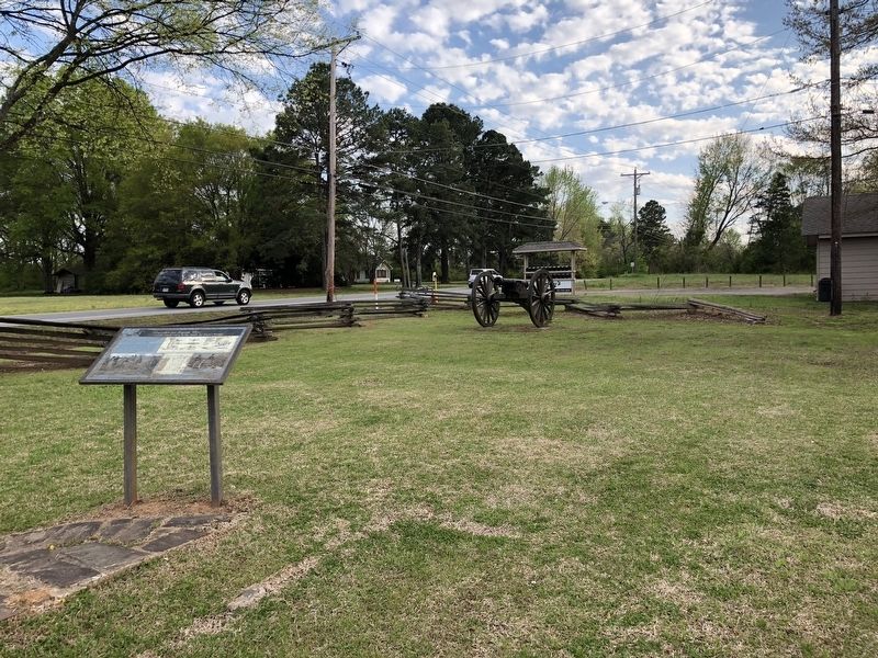
As Reed's Bridge burned and Confederate artillery broke up
the charge of the First Iowa Cavalry Regiment, Union artillery
opened fire on Brigadier General John S. Marmaduke at his
position near Lt. Charlie Bell's "little teaser" prairie gun. . . . — — Map (db m116569) HM
On August 27, 1863 the Federal army was advancing along the Military Road toward Little Rock when its Cavalry Division of 6,000 men under Gen. John W. Davidson attempted a crossing here and was met by a Confederate force of 4,000 under Gen. John S. . . . — — Map (db m116508) HM
On President Clinton Avenue, on the left when traveling east.
1898-Choctaw, Oklahoma & Gulf Railrod (CO&G) entered the Little Rock market by leasing (and later buying) the Little Rock & Memphis Railroad.
1899-CO&G built the Choctaw Station and the railroad bridge over the Arkansas River at . . . — — Map (db m208851) HM
Ferries: Early ferry services were established as a ford on the
Southwest Trail at "the point of rocks" between 1812 and 1819.
Eventually, there were ferries in at least three locations serving
the city, one just above the Old State House, . . . — — Map (db m117432) HM
Post-Civil War, railroads became vital to the Arkansas
economy. Point of Rocks was a natural support for
a railroad bridge on the river. In October 1872,
construction began at the Little Rock with several
tons of rock removed from the . . . — — Map (db m116541) HM
The Little Rock was not always as it is now. To support
the Junction Bridge and ensure an adequate channel for
river traffic, much of the Rock was removed in 1872 and
1884. No one knows how the Point of Rocks looked
before progress took its . . . — — Map (db m116557) HM
A section of the "Little Rock" located at the foot of Rock Street forming the south pier of the railroad bridge over the Arkansas River, being the first rock seen by the French explorer, Bernard De La Harpe, on his voyage from the mouth of the . . . — — Map (db m102141) HM
How the Locks Work
When a boat enters the lock
the gates close and the water
level inside the lock is raised to
the upstream level or lowered
to the downstream level,
depending on which way the
boat is moving. The locks are
filled . . . — — Map (db m208844) HM
Many people have asked about the 'monoliths' of concrete that are a feature of the plazas on the north
and south side of the Big Dam Bridge. These 'monoliths' are a part of the story of the Big Dam Bridge.
The Bridge is not only unique in . . . — — Map (db m208842) HM
On Cook's Landing Road, on the left when traveling east.
Four major bridges connect the various elements of the Arkansas River
Trail, allowing visitors to easily cross the river and explore different areas.
Big Dam Bridge
Dedicated on September 20, 2006, the Big Dam
Bridge is the longest . . . — — Map (db m208848) HM
On Dickerson St 0.3 miles east of South Bettis Street (U.S. 62), in the median.
This is the site of the Old Black River Bridge. After gaining congressional approval, the Arkansas State Highway Commission design the Bridge, and the Pittsburgh-Des Moines Steel Company of Pittsburgh Pennsylvania built it in 1934. The Bridge was . . . — — Map (db m180431) HM
On Golf Course Drive at Cottage Lake Drive, on the right when traveling north on Golf Course Drive.
Searcy Landing in the Civil War
Searcy Landing was a steamboat stop with cotton warehouses before the war. On May 9, 1862, Col. P.J. Osterhaus's 3rd Division of the Union Army of the Southwest built a bridge across the Little Red River, . . . — — Map (db m116325) HM
On South 2nd Street near Main Street, on the right when traveling south.
(lower plaque giving history of the bridge)
This plaque was mounted on the old bridge railing approach.
Mayor Thomas Huie obtained it from the state highway department.
It was restored by Paul Brown of American bronze craft of Judsonia, . . . — — Map (db m256068) HM
The Edward R. Campbell Bridge is a physical testament to the power of elected officials building bridges that benefit not only their constituents, but all future generations. Alameda County Supervisor Edward R. Campbell, having spent most of his . . . — — Map (db m204561) HM
On Alameda Avenue north of Tidal Way, on the right when traveling south.
Originally known as San Antonio Creek – a shallow, marsh-fringed inlet that ended near present-day Coast Guard Island – the Oakland Estuary was transformed into a working harbor under the direction of the Army Corps of Engineers. The harbor plan, . . . — — Map (db m218625) HM
Old Bridge and New Pier
As you walk onto the pier before you, constructed in 2019, you are stepping onto a
piece of transportation history. This pier is built upon two pylons that supported the original San Francisco Bay Bridge near the . . . — — Map (db m159373) HM
The opening of the San Francisco - Oakland Bay Bridge in
1936, and the Golden Gate Bridge in 1937, forever changed
the local economy and transportation habits of the Bay Area,
allowing easier travel and access to new places for work
and . . . — — Map (db m159887) HM
On Leimet Boulevard near Clemens Road, on the right when traveling west.
The Sausal Creek Arch Bridge, commonly known as the Leimert Bridge since its completion in 1926, is a graceful example of a fixed arch bridge. George Posey, Alameda County Surveyor and engineer of the Posey Tunnel connecting Alameda and Oakland, . . . — — Map (db m71767) HM
On Leimert Boulevard east of Park Boulevard, on the right when traveling east.
The Sausal Creek Arch Bridge, commonly known as the Leimert Bridge since its completion in 1926, is a graceful example of a fixed arch bridge. George Posey, Alameda County Surveyor and engineer of the Posey Tube connecting Alameda to Oakland, . . . — — Map (db m223950) HM
On Fourth Street at Harrison Street on Fourth Street. Reported permanently removed.
The Oakland Portal's elaborate Beaux Arts façade conceals eight massive fans that draw in
fresh air and expel foul air to prevent carbon monoxide buildup in the George A. Posey Tube, an underwater automobile tunnel that runs under Harrison Street . . . — — Map (db m145508) HM
Phoebe Hearst's Moorish-style mansion once stood where the Castlewood Country Club now stands, northwest of this location. The mansion was named Hacienda del Pozo de Verona, for its great marble wellhead imported from Verona, Italy.
Western . . . — — Map (db m194786) HM
On December 18, 1872 Ernst Reush, A jealous husband, shot and killed E.H. Erickson, A local saloon owner and Great Saint of Whiskey Pouring, at Erickson's saloon in Silver Mountain City. Reush believed that Erickson had been having an affair with . . . — — Map (db m285000) HM
The Massa Tunnel was dug in the 1850’s on Massa Brothers' land. The tunnel extends 126’ into the east vein of the Mother Lode. Little gold was found. The Kennedy Mine acquired the property in 1898. It and the Argonaut mined the richer west vein . . . — — Map (db m44587) HM
On Highway 32 at Gianella Road, on the right when traveling east on Highway 32.
Built cooperatively by Butte and Glenn Counties, 1908-1911. Designed by John B. Leonard (1864-1945), civil engineer, San Francisco. Built by Cotton Bros. and Co. Oakland. Recorded for the Historic American Engineering Record, 1984. Replaced and . . . — — Map (db m62233) HM
On Honey Run Road at Centerville Road, on the right when traveling north on Honey Run Road. Reported permanently removed.
Honey Run Bridge
Erected
1894
By George Miller
Gold Dredge
The first bucket line gold dredge to operate below the covered bridge used this tumbler – 1898. — — Map (db m29682) HM
Originally constructed on a site one and a half miles northeast of this location in 1856
Rededicated on July 30, 1977
on this Kelly Ridge site
to avoid inundation by the waters of
Oroville Reservoir
State of California - Edmund G. . . . — — Map (db m61597) HM
To commemorate The Mother Orange Tree of Butte County planted at this spot by Judge Joseph Lewis in 1856.
The Bidwell Bar Bridge, first suspension bridge of California, transported from New York via Cape Horn 1853. Completed 1856. . . . — — Map (db m100596) HM
On Main Street, on the right when traveling north.
(There are five markers and one dedication plaque affixed to the flagpole pedestal.)
History of Copperopolis
Copper (for ore) + opolos (for city)
Originally known as Copper Canyon, Copperopolis was established in 1860 when copper . . . — — Map (db m62356) HM
On O'Byrne Ferry Road (State Highway 49), on the right when traveling south.
In 1852 a chain cable bridge replaced the ferries that once crossed here, to be supplanted in its turn by a covered truss structure in 1862. Some writers claimed this was the locale of Bret Harte's Poker Flat. In late “49” there was a large camp . . . — — Map (db m13013) HM
On Boards Crossing Road/Forest Route 5NO2 5 miles south of Ebbetts Pass Scenic Byway (California Highway 4), on the left when traveling south.
A cooperative project of
Sierra Pacific Industries
and
Stanislaus National Forest.
Site of original 1962
bridge destroyed in
mudslide January 1, 1997. — — Map (db m33440) HM
On State Highway 49, on the right when traveling south.
Located on the Stockton-Murphy Road at the fourth crossing of the Calaveras River, this early mining settlement, once called Foremans, was famous in the 1850's for its rich placer ores. Later, it became an important stage and freighting depot and . . . — — Map (db m11969) HM
Center section of the former Colusa Bridge across the Sacramento River at the end of Bridge Street. Constructed 1899-1901 and replaced 1979-80. Nominated for inclusion on Federal Register 1978. — — Map (db m63416) HM
Near San Pablo Avenue 0.1 miles west of Merchant Street.
Alfred 'Al' Zampa was the first born son of Emilio and Maria Zampa, Italian immigrants who migrated to the USA from Abruzzi, Italy. Al was born on March 12, 1905 in Selby, California down river from where this plaque sits. He was the eldest of three . . . — — Map (db m91658) HM
On Mt. Diablo Boulevard near Broadway Plaza, on the left when traveling east.
Walnut Creek's namesake creek is formed under this plaza, where Las Trampas and San Ramon creeks merge. The two creeks bound land known as "Botelho's Island." which had been owned by the pioneer Botelho family. Broadway Plaza, opened in 1951, now . . . — — Map (db m93731) HM
On Duncan Street near North Main Street, on the left when traveling east.
Walnut Creek's namesake creek runs beneath Broadway at the end of this block. Before the creek was "underground" to prevent flooding, a bridge at the end of this street was essential to reach the homes and farms across the creek and to get to the . . . — — Map (db m93864) HM
Near Klamath Beach Road at Coastal Drive, on the right when traveling north.
During Christmas week in 1964, this area) was hit with the heaviest rain ever recorded in the region, Torrential storms dumped as much as 21 inches of warm rain over the mountains, melting the snow pack. Swollen creeks and rivers raged through . . . — — Map (db m285204) HM
On Mt Murphy Road at Coloma Road (California Route 49), on the right when traveling east on Mt Murphy Road.
Coloma’s first two bridges were located about ¼ mile upstream from here. During the summer of 1849 Jim Stephens built a foot-bridge with a 25 cent toll. In 1850 John Little and Edward Raun built a wagon bridge with a toll house that brought in . . . — — Map (db m215522) HM
On Marshall Parkway, on the left when traveling north.
Mining ditches were dug by ditch companies to carry vast amounts of water needed for placer mining. Thousands of miles of ditches and flumes were built in the gold country; some brought immense profits to their owners. As mining declined in the . . . — — Map (db m17484) HM
On Mt Murphy Road at Levee Trail, on the left when traveling east on Mt Murphy Road.
This area held a number of important homes and stores during the gold rush. The first large building in Coloma was built here in 1849 by John T. Little. It contained a store, hotel, restaurant and post office. Little also operated a ferry to cross . . . — — Map (db m215742) HM
On U.S. 50 near Ice House Road, on the right when traveling west.
These stone obelisks are all that’s left of the original four that once stood on the corners of the stone arch bridge spanning the American River from 1900 to 1930.
This monument erected by Caltrans District 3 History Committee and the . . . — — Map (db m23183) HM
On Kings River Road 0.1 miles south of Manning Avenue when traveling east.
In the early 1850's, before it became a town, Reedley was in Mariposa County. The only way to cross the Kings River was doing so at your own risk or to find a ferry and pay a fee to cross. The Reedley area could claim two operating ferries. . . . — — Map (db m77752) HM
Near Route 206 4 miles west of Newville Road (Route 200), on the right when traveling west.
Dedicated to the Noah Simpson family, early
settlers of Stony Creek Valley. The steel girders that form the arch were part of
the original bridge constructed in 1885 and
used until 1961. This site overlooks the
location of the original bridge . . . — — Map (db m172451) HM
On California Route 211 at Depot Street, on the left when traveling south on California Route 211.
Dedicated on November 16, 1911 and affectionately known as the "Queen of Bridges", it was the longest reinforced concrete arch structure in the world at the time of its construction. The bridge was designed by John B. Leonard, Civil Engineer, . . . — — Map (db m71907) HM
On Douglas Avenue 0.3 miles west of 12¾ Avenue, on the right when traveling west.
Founded in 1856 by L.A. Whitmore who operated first Kings River ferry crossing. After 1858 town became stopping place for Butterfield stages. Toll bridge superseded ferry in 1873. On December 26, 1873, Tiburcio Vasquez and bandit gang made bold raid . . . — — Map (db m158224) HM
On Royal Oaks Drive North at Oaks Avenue, on the left when traveling west on Royal Oaks Drive North.
With the 1907 extension of Huntington’s Pacific
Electric system through Duarte to Glendora,
a cut was created to level the railroad’s right
of way in front of L.L. Bradbury’s country home.
To provide access to his home, the site of which
is now . . . — — Map (db m137592) HM
On 6th Street 0.1 miles west of Boyle Avenue, on the right when traveling west.
The original Sixth Street Viaduct, constructed in 1932,
included art deco features, two pairs of iconic steel
arches, and was recognized as Los Angeles Historic
Cultural Monument 905. The 1932 viaduct was designed by
the City of Los Angeles . . . — — Map (db m203789) HM
On Barham Boulevard at U.S. 101, on the right when traveling south on Barham Boulevard.
Federal Works Agency,
Public Works Administration.
John M. Carmody,
Federal Works Administrator.
Franklin D. Roosevelt,
President of the United States.
Barham Blvd Bridge
over Cahuenga Blvd,
1940. — — Map (db m227121) HM
On Cesar E Chavez Avenue east of Alameda Street, on the right when traveling east.
Federal Emergency Administration
of Public Works Project No. 4561.
City of Los Angeles, Frank L Shaw - Mayor.
Board of Public Works...
Bureau of Engineering...
Members of the City Council...
General contractor: Bent . . . — — Map (db m229107) HM
On 6th Street 0.5 miles east of Alameda Avenue, on the right when traveling east.
The original Sixth Street Viaduct, constructed in 1932, included art deco features, two pairs of iconic steel arches, and was recognized as Los Angeles Historic Cultural Monument 905. The 1932 viaduct was designed by the City of Los Angeles Bureau . . . — — Map (db m227992) HM
On Temple Street at Figueroa Street, on the right when traveling west on Temple Street.
Federal Works Agency,
Public Works Administration.
John M. Carmody,
Public Works Administrator.
Franklin D. Roosevelt,
President of the United States.
Temple Street Grade Separation,
1939. — — Map (db m229200) HM
On Soto Street at Huntington Drive, on the right when traveling north on Soto Street.
The Soto Street Bridge was constructed in 1936 to separate vehicular traffic from the Pacific Electric
railroad. Railroads were first introduced to the intersection in 1909 when Pacific Electric, under the
leadership of Henry Huntington, . . . — — Map (db m228371) HM
On Riverside Drive north of Zoo Drive, on the right when traveling north.
A Dangerous Bottleneck
Prior to the Riverside Drive Bridge that you see today, there was once a wooden structure crossing the Los Angeles River in its place. However, this old wooden bridge was inadequate to serve the increasing . . . — — Map (db m223397) HM
On Riverside Drive north of Zoo Drive, on the right when traveling north.
Originally known as the Victory Boulevard bridge, the Riverside Drive bridge was constructed in 1938 to improve a bottleneck caused by an earlier wooden bridge. It was partially funded by President Franklin D. Roosevelt’s Works Progress . . . — — Map (db m129133) HM
Constructed by California Southern Railroad (a Santa Fe subsidiary),
built 1896.
Declared 1988, Historic-Cultural Monument No. 339, City of Los Angeles, Cultural Heritage Commission, Cultural Affairs Department. — — Map (db m205594) HM
On Soto Street just north of Valley Boulevard, on the right when traveling south.
The Soto Street tunnel served an important purpose in the early 1900s.
It provided much needed protection from the dangers of the nearby
Pacific Electric Pasadena Short Line (PE). The PE was a highly used
line with many red cars traversing to . . . — — Map (db m214722) HM
Near the Los Angeles River Bike Path near Chevy Chase Drive.
City of Los Angeles North Atwater Bridge construction completed 2019.
This bridge over the Los Angeles River was made possible by the City of Los Angeles and a generous donation from the La Kretz Family Foundation. Initiated by River LA, . . . — — Map (db m164818) HM
On Beacon Street at 9th Street, on the left when traveling south on Beacon Street.
Vincent Thomas Bridge
The Vincent Thomas Bridge is considered the Port of Los Angeles' official welcoming monument. It was built in 1963 to connect Terminal Island to San Pedro, replacing municipal ferry service.
Initially . . . — — Map (db m224136) HM
On Mulholland Drive at Skirball Center Drive, on the right when traveling west on Mulholland Drive.
In 2012 this bridge replaced the historic Mulholland Drive overcrossing that was demolished to accommodate the widening of the San Diego Freeway (I-405). Built in 1959, the original bridge was determined eligible for listing on the National Register . . . — — Map (db m125489) HM
On Toluca Street just north of 2nd Street, on the right when traveling north.
The 1st Street Viaduct over Glendale Boulevard is a
reinforced concrete bridge with a box girder design
constructed between 1940 and 1942. Designed by the
City of Los Angeles Bureau of Engineering, the viaduct
has Moderne-style architectural . . . — — Map (db m235247) HM
Near Oak Knoll Avenue at Hillcrest Avenue, on the right when traveling south.
Adobe Flores … Pasadena
Built by José Perez in 1839, Headquarters of the
Mexican General Flores, who drew up in this house the terms of
surrender to the American General Fremont.
The image displayed is a facsimile of the . . . — — Map (db m198138) HM
On Orange Grove Boulevard at Colorado Boulevard, on the right when traveling south on Orange Grove Boulevard.
Erected by the California Highway Commission and Division of Highways of the Department of Public Works - named by resolution of the 1953 State Legislature and dedicated to all Pasadena Pioneers, especially the twenty seven who founded this city . . . — — Map (db m161000) HM
On Colorado Boulevard 0.1 miles west of Orange Grove Boulevard, on the left when traveling west.
Waddell & Harrington of Kansas City, Missouri, designed the
Colorado Street Bridge in 1912. J.D.Mercereau Construction of Los
Angeles was the contractor. Dedicated and opened to traffic on
December 13, 1913. Designated as a Historic Civil . . . — — Map (db m161949) HM
This property is listed in the National Register of Historic Places by the United States Department of the Interior.
John K. Van De Kamp Bridge, formerly known as La Loma Bridge is an open-spandrel-arch reinforced concrete bridge . . . — — Map (db m235281) HM
On Colorado Avenue at Ocean Avenue on Colorado Avenue.
Federal Emergency Administration of Public Works.
Franklin D. Roosevelt, President of the United States.
Harold L. Ickes, Administrator of Public Works.
Colorado Avenue Viaduct - 1939. — — Map (db m250275) HM
After a breakwater was built in 1933 & 1934, Santa Monica Harbor became home to a proud collection of yachts, fleets of fishing boats, a cruise liner to Catalina and water taxis which served mobster Tony Cornero's infamous gambling ship, the "SS . . . — — Map (db m185313) HM
On Fair Oaks Avenue at Oaklawn Avenue, on the right when traveling south on Fair Oaks Avenue.
A singular example of functional public art by architects Charles and Henry Greene, this 1906 span was one of the country's first reinforced concrete bridges.
Recognized by Hampton Hotels Save-A-Landmark program as a site worth seeing. . . . — — Map (db m206059) HM
On Torrance Boulevard at Bow Avenue, on the right when traveling east on Torrance Boulevard.
Constructed in 1913, this bridge was a part of the Pacific Electric Railway system which was designated as a Local Historic Civil Engineering Landmark by the American Society of Civil Engineers, Los Angeles section, in 1973. Although the bridge no . . . — — Map (db m140110) HM
This structure replaces Bridge No. 27C0071, a contributing element to the Ross Historic Bridges District, eligible for inclusion in the National Register of Historic Places. The original bridge was completed on January 13, 1910 as part of a $12,500 . . . — — Map (db m63939) HM
A bridge existed in this area as early as 1895, perhaps built by the Northwestern Pacific Railroad to provide access to the train station. It was later replaced by a newer bridge, possibly in 1916. — — Map (db m197099) HM
On Francisco Boulevard East at Main Street, on the right when traveling north on Francisco Boulevard East.
History
The Richmond-San Rafael Bridge opened to traffic in 1956, following 2 years of planning and design and 4 years of construction. At the time, its 4.5 mile-length and double-decker design made it one of the most complex bridges in the . . . — — Map (db m223322) HM
Near Conzelman Road near U.S. 101, on the left when traveling west.
The Golden Gate Bridge, completed in 1937, is a monument of the last century, and could be damaged by a strong earthquake. Seismic retrofit construction is underway to transform the international icon into a strong and flexible structure that can . . . — — Map (db m102776) HM
Near U.S. 101, on the right when traveling north. Reported damaged.
The Golden Gate Bridge is a structure of striking form and elegance. Built in 1937, it remains an indispensable link in the Bay Area's transportation network and a historical monument of civil engineering and construction. The bridge was named for . . . — — Map (db m102433) HM
On Tiburon Boulevard, on the left when traveling north.
(Upper left photo:) The Tiburon Trestle, completed in 1883, was a 750-foot redwood structure that spanned mostly marshland before
attaching to earthen berms at each end. The trestle support beams, which are in front of you, and the berm, . . . — — Map (db m154604) HM
In 1969, a visionary named Sam Shapero (who served as Tiburon’s Town Treasurer), decided that Blackie’s Pasture needed to be preserved and protected.
Sam did two things. He bought one-third of the land and donated it to a foundation he created – . . . — — Map (db m204147) HM
For 84 years, from 1884 to 1967, Tiburon was a railroad town. It started when rail pioneer Peter Donahue moved his North Bay operations down from Petaluma to Point Tiburon to become the rail and ferry terminus for the San Francisco & North Pacific . . . — — Map (db m204399) HM
Near State Highway 49 10.2 miles south of State Highway 132, on the left when traveling south.
From a vista point near the 1,156 long, 130 foot high bridge, completed in 1966. The site of Bagby lies east under, and sometimes exposed beside, the back waters of Lake McClure. Bagby's history passed through three definite developmental eras. . . . — — Map (db m301006) HM
On Golden Chain Highway (State Highway 49) east of Moss Creek Lane, on the right when traveling east.
In the 1972 Federal Highway Administration Contest as the outstanding example of a bridge overpass, tunnel or other highway structure in the United States
On Old Highway Road, on the right when traveling east.
In 1852 Andrew Church established a trading post where a road from the San Joaquin Valley, crossed the Agua Fria Creek. The site, known as Bridgeport, was on the Fremont Grant, about five miles south of Aqua Fria, first county seat of Mariposa . . . — — Map (db m46846) HM
On Oakdale Road south of Turlock Road, on the right when traveling south.
This important Southern Pacific Route was called by many names, also including, "The Stockton-Tulare Railroad", "The Oakdale Line", "The Oakdale-Montpelier Railroad", and "The Eastside Route". There were North and South bound trains daily. . . . — — Map (db m91847) HM
On Colfax Highway (California Route 174), on the left when traveling south on Colfax Highway.
Since 1952 bridges near this site have served as the gateway to western Nevada County. This 1924 span was the first concrete bridge at this site and features a Roman style single arch design, constructed in a continuous pour method.
The Colfax . . . — — Map (db m76345) HM
On South Pine Street south of Spring Street, on the left when traveling north.
Third span of Deer Creek at this location. It is a replica of the single arch steel Gault Bridge (1908-1996) which replaced the suspension bridge (1862-1903) built by Andrew S. Hallidie, who later built the San Francisco Cable Car system. — — Map (db m40275) HM
On Purdon Road, on the right when traveling north.
Built by Cotton Brothers of Oakland, this steel bridge replaced several wooden bridges washed away in floods. It is the only bridge of the half-through truss design remaining in California. Purdon Crossing was a vital link of the main road from . . . — — Map (db m45068) HM
On Donner Pass Road, on the left when traveling east.
Dedicated to the pioneers who blazed the
Overland Trail through these mountains.
Built by the U.S. Bureau of Public Roads and the California Highway Commission
1925-1926.
This tablet placed by the Historic Landmarks Committee of the . . . — — Map (db m94763) HM
On Donner Pass Road, on the right when traveling east.
History
The bridge “eliminated for all time the terrors of the Donner grade from the state highway system of California.”
Automobile travel could be a harrying affair in the old days and Donner Summit was a difficult route. . . . — — Map (db m81898) HM
Near Pleasant Valley Road. Reported permanently removed.
Built in 1862 by David Isaac John Wood with lumber from his mill in Sierra County, this bridge was part of the Virginia Turnpike Company toll road which served the northern mines and the busy Nevada Comstock Lode. Utilizing a combination truss . . . — — Map (db m8540) HM
Near Pleasant Valley Road 7.5 miles north of Route 20, on the left when traveling north.
This covered bridge across the South Fork of the Yuba River at Bridgeport, Nevada Co., Calif. was built by David I. Wood in 1862 with lumber from his mill in Plum Valley, Sierra Co., Calif.
Erected by Columbia Parlor No. 70 N.D.G.W. French . . . — — Map (db m8528) HM
Near Pleasant Valley Road 7.5 miles north of Route 20, on the left when traveling north.
Bridgeport Bridge, or “Wood’s Crossing”, is the longest single span covered bridge in existence. Used since 1862, built by David I. Wood. This plaque is dedicated to those pioneer Americans who came to California in search of a new life and passed . . . — — Map (db m8539) HM
Near Pleasant Valley Road 7.5 miles north of Route 20, on the left when traveling north.
Built in 1862 by David J. Wood with lumber from his mill in Sierra County, the covered bridge was part of the Virginia Turnpike Company toll road that served the northern mines and the Nevada Comstock Lode. The associated ranch and resources for . . . — — Map (db m78339) HM
It was near this site on July 22, 1760 that Captain Gaspar de Portola joined by 63 men and two priests, stepped into history by crossing the Arroyo Trabuco during the first Spanish expedition into Alta California. Today, June 8, 1992, the County of . . . — — Map (db m196167) HM
It was near this site on July 22, 1760 that Captian Gaspar de Portola joined by 63 men and two priests, stepped into history by crossing the Arroyo Trabuco during the first Spanish expedition into Alta California. Today, June 8, 1992, the County of . . . — — Map (db m198396) HM
On Goldenrod Avenue west of 1st Avenue, on the left when traveling south.
This Bridge was built in 1928 for $10,884 and spans 243 feet across what was then known as "Pacific Gulch". It was built to provide convenient access to the beach for residents and visitors to the community.
At the time of construction the . . . — — Map (db m301522) HM
On Goldenrod Avenue north of Seaview Avenue, on the right when traveling north.
This Bridge was built in 1928 for $10,884 and spans 243 feet across what was then known as "Pacific Gulch". It was built to provide convenient access to the beach for residents and visitors to the community.
At the time of construction the . . . — — Map (db m301526) HM
For centuries the Acjechemen, Missionaries, and early settlers used River Street as the path down to the Pacific Ocean.
River Street was originally a path used by the Indigenous people of the area to reach Trabuco Creek. The Creek was one of . . . — — Map (db m276421) HM
3762 entries matched your criteria. Entries 101 through 200 are listed above. ⊲ Previous 100 — Next 100 ⊳