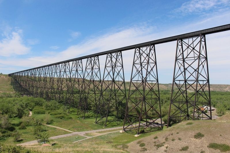
[English] This Canadian Pacific Railway viaduct, built between 1907 and 1909 across the Oldman River Valley, was an engineering triumph. More than 1,600 metres long and 95 metres high, this steel structure is the longest and . . . — — Map (db m196963) HM
[English] On August 7, 1919, Captain E.C. Hoy made the first crossing of the Canadian Rockies by air from Vancouver following a route over Vernon, Grand Forks, Cranbrook, and through Crawford Pass. His Canadian-built Curtiss JN-4 . . . — — Map (db m201700) HM
[English] In 1872, on the western bank of the Oldman River at the present site of the Federal Mine, Nicholas Sheran opened the first coal mine in Alberta. He broke his own trails, found his own markets, and hauled coal by ox-team . . . — — Map (db m220697) HM
Lloydminster City Hall is located on the site of the former Meridian School, which was built in 1925. The eastern entrance replicates the original design of the school, re-using the original brick and tyndall stone from the building. R.L. Wilkin . . . — — Map (db m212401) HM
In 1967, Canada’s centennial year, a caravan of motor vehicles travelled from Winnipeg to Vancouver to celebrate the final stages of construction of a new highway through the Rocky Mountains… the Yellowhead. These people were members of the . . . — — Map (db m212400) HM
Old Mannville was a cluster of commercial and residential buildings constructed on land originally homesteaded by Dan McLean. In anticipation of the arrival of the Canadian Northern Railway, J.B. Burch built a store here in 1904, along the . . . — — Map (db m206503) HM
This is a story about the history of this place from the Îyârhe [ee-YAH-hhay]. Îyârhe means “mountain people.” We are a branch of the Sioux/Dakota/Lakota/Nakoda people, who are now called the Stoney Nakoda Nation. When our grandfathers were . . . — — Map (db m203570) HM
In 1875 the Morleyville church was constructed entirely by hand from logs from surrounding timber. John McDougall, his father, his son and schoolmaster Andrew Sibbald labored to construct the church measuring 47' X 26' 7" wide and 21' 8" high. . . . — — Map (db m214299) HM
Chief Crowchild of the Tsuu T'ina people donated this cabin to be used by a caretaker for the church. The cabin was originally an Indian Agent's cabin on the Tsuu T'ina (Sarcee) Reserve west of Calgary. Workers dismantled it to be transported . . . — — Map (db m214301) HM
Robert Rundle introduced the Stoney people to Christian worship during his visit in 1842. Rundle promised to send missionaries to stay with the Stoney people. In 1873, Rev. George McDougall and his wife Elizabeth, along with sons John and . . . — — Map (db m214298) HM
[north tablet]To the Glory of God and in memory of Rev. George Millward McDougall and Rev. John Chantler McDougall, D.D. father and son and their devoted wives. Combined ministry 77 years. Pioneer missionaries of the . . . — — Map (db m214297) HM
The historic church at the end of this pathway was constructed in 1875. At that time native people were still hunting bison on the prairies. The young nation of Canada was only eight years old; the Canadian Pacific Railway still nine years in . . . — — Map (db m214300) HM
After it closed in 1921, the church was neglected until the early 1950s when a group of volunteers began restoration. A group of men from the United Church formed the Morley Church Restoration Society and began fund-raising to restore the . . . — — Map (db m214296) HM
Sacred to the memory of Rev. George MacDougall aged 54 years ——————————— The deceased was for 16 years Chairman of the Wesleyan Missions in the North-West. He lost his way on the prairie about 40 miles east of this place on January 24th . . . — — Map (db m214291) HM
Rev. George McDougall dedicated his life to frontier mission work. As a young man, George became interested in religion and while attending one of his first revival meetings he met a young Quaker girl, Elizabeth Chantler. They were married in . . . — — Map (db m214278) HM
The name "Stoney" is an English translation of their Assiniboine name which means "the people who cook with stones." The Stoney people are a branch of the Siouan Confederacy. They were comparative latecomers to the area and many of the local place . . . — — Map (db m214276) HM
In A History of Grande Cache, renowned Canadian artist Robert Guest described a typical fur cache. "The cache was made from sturdy logs to withstand the severe winter conditions and the predators such as wolverines and bears, which might try . . . — — Map (db m205223) HM
This building is dedicated to the efforts of Bros. A. C. Hockett and the late John A. Jeffery, Grand Organizers, who instituted Bassano Lodge No. 487 September 21, 1964 — — Map (db m301619) HM
This earth aqueduct was built under an agreement between the governments of Canada and Alberta. It replaces the original concrete flume, constructed in 1912-14 to carry irrigation water across the valley to the Patricia and Tilley areas. The new . . . — — Map (db m301889) HM
[English] A monument to the achievements of those civil engineers who developed irrigation in southern Alberta. [Français] Un monument en hommage aux ingénieurs civils qui ont . . . — — Map (db m301974) HM
Water flowed through the Brooks Aqueduct every year from 1915 until it was replaced in 1979. The engineers who built the Aqueduct planned a delivery rate of about 900 cubic feet (25 cu. m) of water per second. The Aqueduct never managed it. From the . . . — — Map (db m196947) HM
Getting the water in and out of the Aqueduct wasn't the only challenge. As it marched across the valley it would run smack into the CPR tracks. The Aqueduct as planned was not high enough for trains to go under it. And the construction required to . . . — — Map (db m196952) HM
Many settlers in the Eastern Irrigation Section had a hard time in the 1920s and 1930s. Low grain prices, deteriorating soils from alkali seepage into fields, and inexperience with irrigation farming techniques were some of the problems. Even though . . . — — Map (db m196954) HM
1916 “On April 6 … a camp … was located at the aqueduct for the purpose of tightening and repacking the metal bands at six expansion joints, and also of putting on additional bands … Total cost $160.00.”
1917 “Work was started on . . . — — Map (db m196955) HM
[English] The CPR built this reinforced concrete aqueduct between 1912 and 1914. It was part of a large irrigation scheme using water diverted from the Bow River to transform 55,000 hectares east of Brooks from semi-arid rangeland to farmland . . . — — Map (db m196937) HM
“So he grabbed hold of a pick, he just kind of lifted it up a bit and then drove it right through, right through the bowl. Well, as the pick went through the bowl his hair stood straight up on end, I can assure . . . — — Map (db m196950) HM
In the early 1900s the Canadian Pacific Railroad began construction of a huge irrigation project in Alberta comprising over a million hectares (3 million acres). Part of this original block land grant to the railway is now known as the Eastern . . . — — Map (db m196941) HM
Canadian Pacific Railway (CPR) first built a wooden rail station on this site
in 1892. The building burned down in 1928 and was replaced in 1929 with
this two-storey brick station, which cost $19,871 to construct. The CPR station
played a key . . . — — Map (db m289876) HM
The coming of the railway to Wabamun initiated many changes. Old Wabamun was moved across the lake to its present location. The rails ran through Wabamun in 1909 and a railway station was built. It consisted of office, waiting room, freight and . . . — — Map (db m212500) HM
The Windsor Hotel was built by Gordon Steeves and Tom
Madden in 1905. Tom and his wife, Ellen operated the hotel
and were renowned for their generosity, hospitality and
congeniality. The hotel was known for its high standards of
cleanliness and . . . — — Map (db m288970) HM
On September 30, 1896 a Blood Indian named Si'okskitsis, or
Charcoal, killed his wife's lover. Charcoal's wife's affair with her
cousin, Medicine Pipe Stem, broke one of the most fundamental
rules of Blood society. When they would not end their . . . — — Map (db m301882) HM
Who was Maskipeton? He was a Cree, born around 1807. He became chief and led a Cree band that hunted south of today's Edmonton, but that also ranged into Saskatchewan and Montana. He traded into the Missouri River area. He was a warrior, respected . . . — — Map (db m206506) HM
As you look at this structure, covered by a facade of glass and stucco, it's hard to imagine this is Red Deer's oldest building still located on its original site. Known as the Brumpton Store, it is reminiscent of a very different Red Deer — one . . . — — Map (db m206611) HM
At the end of World War II, life was getting back to normal. Soldiers returned home from the battlefields, families were reunited and the strain of wartime was replaced by a tangible feeling of prosperity. Businesses in Red Deer flourished, and the . . . — — Map (db m206759) HM
In the winter of 1890, the arrival of the Calgary and Edmonton Railway brought significant changes to the hamlet of Red Deer. Its strategic location midway between the larger centres positioned Red Deer as a focal point for the distribution of . . . — — Map (db m206609) HM
The smell of food wafting onto the street is as enticing now as it was when George Moon opened his first café in 1916. Had you been a patron of Moon's restaurant in the early years, you would have found that good food, plenty of company and a . . . — — Map (db m206694) HM
Hugh Farthing built this Prairie Vernacular style building in 1939. The main floor was used as his photography studio. The second floor had a six-roomed suite used as his residence. The signage was simply “Farthing’s.” Today the signage font and . . . — — Map (db m206763) HM
Red Deer's population grew rapidly during the Second World War due to the construction of military training camps and the onset of Alberta's energy boom. In response to the city's growth, the Federal Building, which housed the post office, was . . . — — Map (db m197005) HM
Is there a Roman influence in Red Deer? The Greene Block in front of you could make such a claim, as its origins can be traced to a Romanesque revival style of architecture that was pieced together with sandstone blocks from a local quarry. The . . . — — Map (db m206712) HM
In 1935, Mrs. Sadie Collins made the local newspaper when she offered cash to purchase this property on Ross Street. It was unusual for a woman to start a new business venture in the middle of the Great Depression, so Collins made the news several . . . — — Map (db m206778) HM
The October 26, 1955, edition of the Red Deer Advocate stated there would be big changes in downtown Red Deer — the old Horsley Pharmacy building located at this corner would be torn down and a new Horsley Block would take its place. Richard Earl . . . — — Map (db m206841) HM
Mable Lee Fong and Herschell N. Bryant constructed this building in 1947 to house the Paris Cafe. This solid, simply detailed masonry building symbolized post war Red Deer. It replaced a 40 year old structure that had also served as the Paris Cafe. . . . — — Map (db m206876) HM
The austere brick walls and Tyndall limestone columns of the Old Court House convey a sense of awe. This was intentional, as the building's Classical Revival style was meant to give the impression of power and civilization – attributes designed . . . — — Map (db m197003) HM
Built in 1914 in the Gothic Revival style, the Armoury was constructed as the headquarters of the 35th Central Alberta Horse Regiment. The Armoury served as a recruitment office and training centre for the Department of Militia and Defence for more . . . — — Map (db m197012) HM
[First plaque]
In proud and grateful
remembrance of those
who made the supreme
sacrifice in the wars
1914 – 1918
1939 – 1945
1950 – 1953
[Second plaque]
If ye break faith
with us who die
we shall not sleep . . . — — Map (db m197000) WM
Rev. Dr. Leonard Gaetz, founder of Red Deer, gazes down main street. A Methodist minister from Nova Scotia, Rev. Gaetz came to the Red Deer Valley in 1884. He quickly distinguished himself as a farmer, and became an outstanding and eloquent . . . — — Map (db m206970) HM
Standing at this spot in 1893, you would have heard whinnying horses and seen bustling activity at the North West Mounted Police stable. That year the police detachment moved from Fort Normandeau to the new community of Red Deer, and they built . . . — — Map (db m206882) HM
Looking toward Ross Street on your right, you see the beautiful sandstone structure of the Greene Block. In front of you, the historic brick building connects with the one beside it, stretching all the way down to the corner. These three buildings . . . — — Map (db m206972) HM
Originally Presbyterian, this church was built — and most likely designed — by Andrew and Robert Chapman in 1909 to replace the smaller, white clapboard structure of 1901. The 200-seat church was consecrated in February 1910. In 1925, the members . . . — — Map (db m202496) HM
CNR Water Tank History
Heinsburg became a terminal and turn around point for the Canadian National Railway (CNR) Coronado sub-division in the 1920's after the proposed Heinsburg-Frenchman Butte link was cancelled. A water tank was needed at . . . — — Map (db m197045) HM
The turntable was one means of turning steam locomotives and an essential component of the roundhouse complex. It consisted of a revolving bridge, balanced on a centre bearing, in a circular pit. After dumping their fires at the ash pit, locomotives . . . — — Map (db m197013) HM
Every divisional point had an engine house or “shop” as it was commonly referred to. It was in these structures that after each run, steam locomotives were checked, cleaned, and miscellaneous light repairs performed. The “roundhouse,” known as such . . . — — Map (db m197014) HM
The Alberta Company of the Daughters of the Utah Pioneers dedicate this site in the memory of the early Mormon Pioneers who came to Canada in 1903 and settled here. They had the foresight to see that this barren stretch of prairie land, with a lone . . . — — Map (db m202487) HM
In 1897 a rancher drove the first herd of cattle into the Vermilion area, to a site about two miles east of the present day town, but it was only after the region was surveyed in 1902 that significant numbers of settlers from Eastern Canada, . . . — — Map (db m212197) HM
Like many other communities in Alberta, Wainwright is where it is today because of a railway. The Grand Trunk Pacific Railway (GTPR) surveyed the townsite in 1908, forcing the moving of buildings from Denwood 2.5 miles to the new town. Following its . . . — — Map (db m197033) HM
West of Wainwright the railway met a deep challenge, a glorious valley that was home to the Battle River. In 1907, the concrete footings of the bridge that would span the valley were poured. Farmers and other contractors hauled supplies to the site . . . — — Map (db m197037) HM
[World War I plaque]
These went and came not again
In memory of those from
this community who gave
their lives in the Great War.
H.C. Barss • J. Berry • P.A. Conneau • J. Coutts • J. Crompton • A. Dalton • J. Edmonds • J. Elliott • . . . — — Map (db m197042) WM
Old Town Hall is a neo classical two storey brick building built in 1929. Prominent features of this style include the building's symmetrical facade, decorated cornice with dentil detailing and decorate lintels above the window and door openings. . . . — — Map (db m197041) HM
ENGLISH INSCRIPTION
Western Canada’s first producing oil was drilled in this valley at the turn of the 20th century. This success spurred further activity in this area, attracting more drilling and workers. A.P. Patrick, an investor . . . — — Map (db m82965) HM
(Panel 1)
Bears Discover Oil?!
Oil seeps in this area were well known to Aboriginal peoples, who may have found them while observing bears. Bears are attracted by the smell of oil and may roll in it to rid themselves of . . . — — Map (db m242308) HM
Did you know Waterton contains two national historic sites? Many more are nearby, some managed by Parks Canada and some by other agencies and groups. National historic sites celebrate over 1,500 places, persons and events important to Canadians. . . . — — Map (db m82964) HM
[English:]
Welcome to Waterton Lakes National Park of Canada
National Parks protect the natural landscapes of Canada and also provide great places for outdoor adventures and connecting with nature.
As you enjoy the park . . . — — Map (db m82962) HM
According to legend, when the first CPR train pulled in at the 12th siding west of Medicine Hat in 1883, a group of VIP passengers got off the train to see the Blackfoot Reserve. One of these men was Count Gleichen (pronounced Glaiken), an investor . . . — — Map (db m202492) HM
When the railway reached Claresholm in 1891 a converted box car served as the first train station. It was replaced in 1895 by a wood frame building. By 1910 the growing Town of Claresholm required a larger, more permanent train station.
The . . . — — Map (db m196986) HM
Born in Frankville, Ontario, a graduate of Ottawa Normal School, Louise McKinney, with her husband and child, settled at Claresholm, Alberta, in 1903. An active member of the WCTU and the IODE and a tireless worker for social causes . . . — — Map (db m289875) HM
Born in Montreal, Henrietta Muir founded the Working Girls' Association in that city and, with her sister, edited "The Working Woman of Canada". Moving west she continued her espousal of social reform. An early member of the National . . . — — Map (db m289872) HM
The Oldman River was often impassable due to spring run off or heavy rains. In 1903, during a particularly bad flood, several people drowned trying to cross the river and residents petitioned the Territorial and Dominion governments to build a . . . — — Map (db m196980) HM
[English] Between 1888 and 1905 the Government of Canada built a dozen court houses to serve the new settlements on the prairies. Most of these buildings were phased out of service and eventually demolished following the implementation of the . . . — — Map (db m196983) HM
The earliest trade route between eastward and northward flowing waters followed the Clearwater River and the Methye Portage.
Discovered by Peter Pond in 1778 and used continuously for more than a century by fur-traders and explorers, including . . . — — Map (db m8814) HM
In the early 1800s both the North West and Hudson's Bay companies recruited men from Iroquois settlements around Montreal, Quebec, and Cornwall, Ontario, to work as canoemen, hunters and trappers. Their skills in these occupations gave them an . . . — — Map (db m203626) HM
Sproat Lake is named for Gilbert Malcolm Sproat, scholar, author, anthropologist, businessman, and avid British Columbian from his arrival in 1860. He co-founded Port Alberni's first sawmill in 1861, was British Columbia's first agent-general in . . . — — Map (db m188030) HM
[Upper Marker]:
Pedro de Alberni, Captain of the Catalan Volunteers and Commander of the Spanish Establishment at Santa Cruz de Nootka, 1790-1792.
Offered by the Government of Spain on the occasion of the visit of the Spanish . . . — — Map (db m9155) HM
Harvesting of the forest has long been an important aspect of life on the Pacific Coast. The native people were the first to utilize this valuable resource in the construction of dwellings, canoes, and implements. In the nineteenth . . . — — Map (db m9192) HM
Amphitrite Point was named after the naval warship, H.M.S. Amphitrite, in 1859 by Captain George H. Richards of the Royal Navy. Captain Richards was responsible for surveying much of Vancouver Island's coastline during this period.
The original . . . — — Map (db m198567) HM
The last spike in Canada's second trans-continental railroad was driven near this site on April 7, 1914. The Grand Trunk Pacific became the most important factor in the dvelopment of Central British Columbia. However, financial problems plagued the . . . — — Map (db m187999) HM
In 1952, the Kenney Dam was constructed on the Nechako River to service the new Alcan aluminum smelter at Kitimat, resulting in the creation of the Nechako Reservoir and the relocation of over 75 families. The damming also linked the rivers and . . . — — Map (db m8855) HM
Perry Collins, an American, envisioned a land route to link America and Asia by telegraph. All attempts to lay a cable across the Atlantic had failed.
Western Union had completed 800 miles northerly from New Westminster in 1865-66, when the ocean . . . — — Map (db m187980) HM
The mound in the centre of the quarry was of an inferior grade of limestone and therefore not quarried. Left intact, it provided a natural viewpoint amid the developing garden beds. Jennie Butchart planted a pair of arbor vitae (trees of . . . — — Map (db m74451) HM
Eagle with Salmon, Orca, Bear with Salmon
This Totem Pole, carve in Contemporary Coast Salish style by master carver Doug LaFortune of the Tsawout First Nation, was dedicated on September 9th, 2004 in celebration of the 100th anniversary of . . . — — Map (db m74456) HM
Under the sponsorship of Mr. and Mrs. Ian Ross, the Victoria Symphony Orchestra performed summer concerts on the main lawn between 1953 and 1967. Conducted by Hans Gruber they featured many international artists such as Teresa Stratas, Bernard . . . — — Map (db m74461) HM
Once the location of a large Japanese teahouse, the view from the fountain is a commanding one of the Butchart Residence across the Main Lawn. — — Map (db m74485) HM
The Aeolian Pipe Organ played at The Butchart Gardens is an early twentieth century residence instrument equipped with its own pneumatic player. Built by the Aeolian Company of New York this model, once owned by Vancouver department store owner, . . . — — Map (db m74479) HM
The present Rose Garden was built in 1929 and 1930 on the site of the Butchart's vegetable garden. The design was developed by Butler Sturtevant, a Seattle landscape artist, and adapted by Jennie Butchart. The head gardener at the time, Bob . . . — — Map (db m74483) HM
This smaller quarry was a source of limestone in the 1860s. It was here that Ian Ross, grandson of Mr. and Mrs. Butchart, devised his spectacular fountain with the assistance of his plumber, Adrian Butler and his electrician, Vic Dawson. The Ross . . . — — Map (db m74441) HM
Directly behind the Ross Fountain lies Tod Inlet and the site of the Vancouver Portland Cement Company established in 1904. Adjacent to the plant at Tod Inlet was a village that housed the employees. — — Map (db m74444) HM
In 1903, the land now occupied by the Butchart Gardens was purchased from a local dairy farmer, Mr. Fernie. Reservoirs were excavated in 1969 to ensure a water supply for irrigation. The single jet fountain was installed to aerate the water supply . . . — — Map (db m74459) HM
The factory buildings have been demolished and the land is now designated as provincial parkland. The one remaining chimney is within The Butchart Gardens and stands as a beacon to the cement industry it once served. — — Map (db m74447) HM
This pond was designed by Mr. Butchart for his collection of ducks in 1931. Beyond is the entrance to the Italian Garden through a Lawson cypress hedge. — — Map (db m74549) HM
Limestone was also quarried up the hill from the Sunken Garden. It was transported in ore buckets suspended on cables high above ground from some half a mile away. — — Map (db m74432) HM
The original Porcellino, or little pig, sits on the south side of the Straw Market in Florence, Italy. For generations his nose has been affectionately rubbed to bring good luck, so that today his snout is finely burnished.
About 1620 Pietro . . . — — Map (db m74552) HM
Jennie Butchart began to shape this magnificent landscape in 1904. She established, in the style of the grand estates of the period, several distinct gardens to evoke a range of aesthetic experiences. An abandoned limestone quarry was . . . — — Map (db m74419) HM
8437 entries matched your criteria. Entries 201 through 300 are listed above. ⊲ Previous 100 — Next 100 ⊳