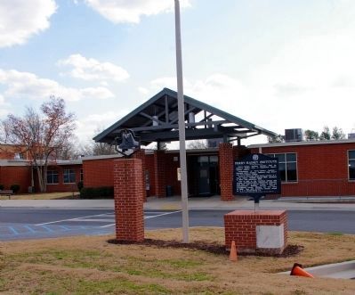
On 6th Avenue at 7th Street, on the right when traveling east on 6th Avenue.
Perry-Rainey Institute founded 1892 by Mulberry Baptist Assn. at Appalachee Baptist Church, Auburn.
Predecessors of Perry-Rainey Institute - Harmony Grove Academy, Mulberry High School and Perry-Rainey College.
Named for Reverend Hiram . . . — — Map (db m14883) HM
Near Christmas Avenue (Georgia Route 11) at Manger Avenue, on the right when traveling south.
Oldest Methodist Church in Barrow County, organized in the 1780’s. Services first held two miles N.E. in log house. In 1790 a church was built nearby. The present site was originally a camp ground with an arbor, tents & cottages for camp meetings. . . . — — Map (db m46843) HM
On Old Thompson Mill Road 0.1 miles south of Farm Market Road, on the right when traveling south.
Clayborn Dalton built an arbor for public Worship across Mulberry River in Jackson County in the early 1800’s. It was called “Dalton’s Stand”. In 1813 the church was moved on this side of Mulberry River near the Maynard Cemetery. Rev. . . . — — Map (db m16125) HM
On Atlanta Highway Southeast 0.3 miles east of Jefferson Street, on the right when traveling east.
First Georgia Chapter Future Farmers of America was located at Statham Consolidated High School, Statham, Georgia.
Organized October 1928 and chartered by State Association January 16, 1929.
Officers were:
William R Bowdoin, President . . . — — Map (db m180659) HM
Near Broad Street at Elizabeth Street, on the right when traveling west.
First Georgia Chapter Future Farmers of America was located at Statham Consolidated High School, Statham, Georgia.
Organized October 1928 and chartered by State Association January 16, 1929.
Officers were:
William R. Bowdoin, President . . . — — Map (db m181830) HM
On Broad Street 0 miles east of Elizabeth Street, on the left when traveling east.
Educator; 52 years service in education. Born Feb. 12, 1900 Ila, Ga., Graduate of University of Georgia. Taught: Maysville, Cornelia, Buford 1920-1933. Principal - Coach Statham School 1933 - 1957. Supt. Barrow County Schools 1957 - 1965. Professor . . . — — Map (db m17364) HM
On Broad Street at Wise Court, on the right when traveling east on Broad Street.
Built circa 1850. Owned by M. John C. Statham. He provided homes for widows of Civil War Veterans; donated land for right-of-way of railroad; streets for town, and a lot for a Methodist Church -- now the city cemetery. Statham, incorporated Dec. 20, . . . — — Map (db m17348) HM
On Georgia Route 82 at milepost 4, 0.1 miles east of Steed Road, on the right when traveling east.
Served 3 years in Revolutionary War from Dinwiddie Co., Va. in Buford’s Detachment.
Lost an arm at Waxhaws, May 29, 1780.
Remembered as successful business man, educator and civic worker, but most outstanding as devout Methodist minister. . . . — — Map (db m19763) HM
On North Broad Street (Georgia Route 11) at West Athens Street ( Route 211), on the right when traveling south on North Broad Street.
Barrow County was created by Act of July 7, 1914 from Gwinnett, Jackson and Walton Counties. It was named for David Crenshaw Barrow, Chancellor of the University of Georgia for many years. Born in Oglethorpe County, October 18, 1852, he died in . . . — — Map (db m19070) HM
On Thompson Mill Road (Georgia Route 211) 0.1 miles north of Will Maynard Road, on the right when traveling north.
On July 31, 1864, at the Battle of Sunshine Church (19 miles NE of Macon), Maj. Gen. Geo. Stoneman [US] surrendered with 600 men to Brig. Gen. Alfred Iverson, Jr., [CS], after covering the escape of Adams’ and Capron’s brigades of his cavalry . . . — — Map (db m23454) HM
On Porter Street 0 miles west of North Broad Street ( Route 53), on the right when traveling east.
This steam locomotive was presented to the City of Winder and Barrow County in 1959 by the Seaboard Air Line Railroad Company. It was placed here as a permanent exhibit in memory of the important service engines of this type rendered to the country. . . . — — Map (db m14528) HM
On Fort Yargo Road 1 mile south of Loganville Highway ( Highway 81), on the right when traveling south.
In Memory of Charles O. Maddox 1887 – 1973 Banker, Farmer, Conservationist Purchased and held for 18 years 1800 acres of land In 1954 he transferred the land to the State of Georgia at no personal gain His vision was then fulfilled . . . — — Map (db m187403) HM
On West Athens Street (Georgia Route 211) 0 miles east of Church Street, on the left when traveling east.
In 1836 Byrd Betts, Pioneer Steward of the Concord Methodist Church, later to become the First Methodist Church of Winder, gave 10 acres land for the church and cemetery. Those known buried here.
On Fort Yargo Road 0.2 miles east of South Broad Street (State Highway 81), on the left when traveling south.
Between the Oconee & Ocmulgee In the late 1700s, the (Muscogee) Creek village of Snoden, present-day Winder, was located within the unbroken forests of Georgia's wilderness. Numerous waterways crisscrossed the landscape supplying . . . — — Map (db m187100) HM
On Broad Street 0.4 miles south of South Broad Street ( Route 81), on the left when traveling south.
This remarkably preserved log blockhouse was built in 1793, according to historians. There are several references to Fort Yargo as existing prior to 1800. Its location is given as three miles southwest of “Jug Tavern,” original name for Winder. . . . — — Map (db m22396) HM
Near Fort Yargo Road east of South Broad Street ( Highway 81), on the left when traveling south.
At one time, settlers used beehive ovens to bake all kinds of foods. Taking its name from its shape, the beehive oven can be found in all parts of the world even today. They are simple to build from clay and straw so there is little or no cost — . . . — — Map (db m312017) HM
Near Fort Yargo Road east of South Broad Street ( Highway 81), on the left when traveling south.
Imagine this log building being occupied by 30 to 50 people while under attack by Indians. That was its purpose when it was built in 1792. Settlers in the area took refuge in the fort during times of threat or attack. When it was not being used for . . . — — Map (db m187377) HM
Near Fort Yargo Road east of South Broad Street ( Highway 81), on the left when traveling south.
Small forts sprang up across Georgia's Indian lands during and after the Revolutionary War. The Creek, Cherokee, and other native peoples were drawn into the conflict by the British and fought skirmishes against the settlers who were establishing . . . — — Map (db m187300) HM
Near Fort Yargo Road east of South Broad Street ( Highway 81), on the left when traveling south.
Settlers established farms as they arrived in new areas. They cleared forest and brush and built fences to corral their livestock, to mark their boundaries, and to keep out predators. The type of fence they built depended on available materials and . . . — — Map (db m187366) HM
Near Fort Yargo Road east of South Broad Street ( Highway 81), on the left when traveling south.
Fort Yargo benefits from a group of volunteer living historians who assist in maintaining the original 1790s blockhouse structure, as well as providing demonstrations of the lifeways and skills of the late 18th and very early 19th centuries. The . . . — — Map (db m187354) HM
Near Fort Yargo Road east of South Broad Street ( Highway 81), on the left when traveling south.
Fort Yargo resembles many log cabins built across the southern highlands, especially those of Appalachia. It is one and one-half stories, with front and back doors opposite to each other for air flow during the warmer months. It has a shake roof . . . — — Map (db m187400) HM
Near Fort Yargo Road east of South Broad Street ( Highway 81), on the left when traveling south.
Fort Yargo's smokehouse is a reconstruction and is in use most winters. Smokehouses served to cure meat or fish with smoke and salt. Before the invention of refrigeration, fresh meat would not last very long unless it was "smoked" or frozen. In the . . . — — Map (db m187402) HM
On King Street at Wood Street, on the right when traveling north on King Street.
Glenwood Elementary and High School was established in 1951 as one of Georgia’s first public consolidated schools for African Americans. Part of a statewide equalization effort to improve school buildings and preserve segregation, Glenwood became . . . — — Map (db m56487) HM
Near Park Avenue at East Athens Street, on the right when traveling south.
Hal Jackson was a native of Winder, Georgia born on October 1, 1910 to J. Roy and Emma Jackson. Other than the time he served in the Army Air Force during World War II, Winder was his home. He married Katherine Adair on December 25, 1943, and they . . . — — Map (db m187287) HM
On West Athens Street (Georgia Route 211) at North Broad Street ( Route 11), on the right when traveling east on West Athens Street.
This obelisk marked the intersection of the boundaries of Jackson, Walton, and Gwinnett Counties from which Barrow County was formed in 1914. The obelisk location was the center of the intersection of Broad and Athens Streets. This obelisk . . . — — Map (db m187291) HM
On Fort Yargo Road 1 mile south of Loganville Highway ( Highway 81), on the right when traveling south.
Built under the Watershed Protection and Flood Prevention Act 83rd Congress — 1954 by Barrow County, Georgia Oconee River Soil and Water Conservation District City Government of Winder Department of State Parks of Georgia with assistance . . . — — Map (db m173170) HM
On Gainesville Highway (Georgia Route 53) at Rockwell Church Road, on the right when traveling north on Gainesville Highway.
Organized 1839 — second oldest Universalist Church in Georgia. Located here near original site of Rockwell School, oldest school in this section, and Rockwell Masonic Lodge. Confederate Soldiers enlisted and drilled here 1861-1865. Church . . . — — Map (db m19548) HM
On Atlanta Highway SE (U.S. 29) 0 miles east of Russell Cemetery Road, on the right when traveling east.
The Russell House was built in 1912 by Richard Brevard Russell, Sr., B. 1861 - D. 1938, and his wife, Ina Dillard, B. 1868 - D. 1953, who were married June 24, 1891. Fifteen children were born of this marriage. Judge Russell was elected Chief . . . — — Map (db m17288) HM
On North Broad Street (Georgia Route 11) at Laura Street, on the right when traveling south on North Broad Street.
Closing in on Atlanta in July, 1864, Maj. Gen. W.T. Sherman found it "too strong to assault and too extensive to invest." To force its evacuation, he sent Maj. Gen. Geo. Stoneman's cavalry [US] to cut the Macon railway by which its defenders were . . . — — Map (db m17307) HM
On West Athens Street (Georgia Route 211) at Church Street, on the left when traveling east on West Athens Street.
For years inestimable the CREEK INDIAN VILLAGE of SNODON stood here. In 1793 ALONZO DRAPER, HOMER JACKSON and HERMAN SCUPEEN and their families became the first white people to establish homes in SNODON. This same year SNODON became JUG TAVERN. . . . — — Map (db m17349) HM
On Cottage Lane east of Fort Yargo Road, in the median.
Completed in 1971, Will-A-Way Recreational Area was the nation's first comprehensive outdoor recreational facility designed for people with disabilities. Beginning in 1966, the Georgia Department of State Parks met with multiple agencies to develop . . . — — Map (db m229236) HM
On Ellenwood Drive at College View Street, on the right when traveling north on Ellenwood Drive.
This park is the last piece of unused land of the original campus of Bowdon College (1856-1936). It was also the backyard of the McDaniel-Whatley home, the last remaining building of that institution. Mr. Vachel D. Whatley Sr. graduated from Bowdon . . . — — Map (db m108112) HM
On City Hall Avenue 0 miles east of Wood Alley, on the right when traveling east.
Bowdon is near the geographical center of the last land in Georgia owned by the Creek Nation and ceded to the U.S. This tract, approximately 550 sq. mi. in area, is 80 mi long and 10 mi. wide at its widest point.
When Carroll County was . . . — — Map (db m31329) HM
On West College Street (Georgia Route 166) 0 miles west of College View Street, on the right when traveling west.
Bowdon College was Georgia’s fifth chartered institution of higher education and first coeducational institution. Bowdon was a frontier community of merchants and yeomen who nourished the growth of a school where earnest students of limited means . . . — — Map (db m31328) HM
On U.S. 27 at Interstate 20, on the right when traveling north on U.S. 27.
When Georgians B.F. White and E.J. King compiled the songbook, The Sacred Harp, in 1844, they were continuing a singing tradition, which would ultimately become identified with the book. Thousands of southerners would be exposed to music . . . — — Map (db m10036) HM
On Rome Street at Alabama Street, on the left when traveling north on Rome Street.
Carrollton was incorporated December 22, 1829, and named in honor of Charles Carroll, last living signer of the Declaration of Independence.
In 1830, the town was surveyed and lots were laid out, with the central feature being the town square, . . . — — Map (db m115249) HM
On Newnan Street (Georgia Route 166) at Dixie Street, on the right when traveling east on Newnan Street.
Carroll County, created by an act of the Georgia legislature in December, 1826, proudly bears the name of Charles Carroll, of Carrollton.
Charles Carroll was born in Annapolis, Maryland, in 1737. He attended preparatory schools in this country . . . — — Map (db m12872) HM
On Dixie Street 2 miles south of West Avenue, on the left when traveling south.
During the war between the states Carrollton was spared a bloody battle but she sustained four raids by Union troops. The last raid occurred 15 days after the surrender at Appomattox when troops commended by Union General John Croxton, returning . . . — — Map (db m12871) HM
On Maple Street (Georgia Route 166) 0 miles east of W. Lake Drive, on the right when traveling west.
In 1936, a young attorney from the Victory community began investigating the possibility of bringing electric service to rural farms and homes in the West Georgia area. Together with rural merchants, farmers, a preacher and a mail carrier, they . . . — — Map (db m12804) HM
On Newnan Street (Georgia Route 166) east of South Tanner Street, on the right when traveling east.
Born within a few miles of each other were six people who are recognized as giants of industry in the southeast. Asa G. Candler of Villa Rica was founder and first president of Coca-Cola; Sam Candler Dobbs, president of Coca-Cola; Arthur Acklen, . . . — — Map (db m61023) HM
On Maple Street at Front Campus Drive, on the right when traveling west on Maple Street.
In January, 1908, the Fourth District Agricultural and Mechanical School opened here with 96 students under Principal John Holland Melson. In 1933 the state withdrew support from its agricultural high schools and also Bowdon College, eleven miles . . . — — Map (db m195815) HM
On Bankhead Highway (U.S. 78) just west of South Candler Street, on the right when traveling east.
The Bank of Villa Rica was Carroll County’s oldest financial institution, and one of the oldest financial institutions in the State of Georgia. The bank was chartered with $15,000 of capital when it opened in 1899. This was one of the few banks that . . . — — Map (db m107248) HM
On South Carroll Street near South Carroll Road and Montgomery Street (U.S.78) (U.S. 78), on the left when traveling south.
The Villa Rica bus station, formerly located on this site, was on the route of the 1961 Freedom Riders that departed Washington, D.C. on May 4, 1961 with New Orleans, Louisiana, as its final destination.
Freedom riders were civil rights . . . — — Map (db m42416) HM
On Rockmart Road (Georgia Route 101) 0.2 miles north of North Dogwood Street, on the right when traveling north.
The Fullerville Jail served the city of Fullerville, Ga. from 1916 to 1956. According to former Fullervillions, the city’s first jail was made of wood and burned to the ground. According to former Fullervillions who witnessed the burning of the . . . — — Map (db m108708) HM
On Tyson Road 0.5 miles north of Flat Rock Road, on the right when traveling north.
In the mid-1600s, John Tyson traveled from the British Isles to Virginia. Over the next 200 years, his descendents migrated to North Carolina and on to Georgia. Alexander, Clement, and Jehu Tyson and their mother Penelope settled this land in 1853. . . . — — Map (db m10041) HM
On North Carroll Road at East Church Street, on the right when traveling east on North Carroll Road.
This Amphitheater is located on the site of what was once the heart of commerce in Villa Rica for more than 100 years.
By 1900, the two–block area to the east of here was developed by the Villa Rica Cotton Oil Mill, whose . . . — — Map (db m111229) HM
On West Bankhead Highway (Georgia Route 78) at South Dogwood Drive, on the left when traveling west on West Bankhead Highway.
Thomas Andrew Dorsey, composer of over 400 blues and gospel songs, lived here following his birth in Villa Rica on July 1, 1899. At Mt. Prospect Baptist Church he was exposed to shape-note singing and at home learned to play a used pump organ, . . . — — Map (db m10043) HM
On North Carroll Road at Main Street ( Route 61) when traveling south on North Carroll Road.
Thomas Andrew Dorsey was born July 1, 1899, in Villa Rica. He learned to play the piano as a young man. His blues style combined with southern Christian praise songs earned him the title “The Father of Gospel Music.”
His best known . . . — — Map (db m111198) HM
On Bankhead Highway (U.S. 78) at South Candler Street, on the left when traveling west on Bankhead Highway.
Around 11:00 a.m. on December 5, 1957, a natural gas leak under Berry’s Pharmacy caused an explosion that destroyed four buildings and damaged several others in Villa Rica’s downtown. The explosion killed twelve and injured twenty. The tragedy . . . — — Map (db m10044) HM
On West Bankhead Highway (U.S. 78) at South Candler Street, on the right when traveling west on West Bankhead Highway.
This monument is placed in memory of those lives lost in the explosion of Villa Rica Dec. 5, 1957
Margaret Berry
Rob Broom
Dr. Jack Burnham
Carolyn Davis
Johnny Dyer
O.T. Dyer
Kenneth Hendrix
Oscar Hixon
Rozella Johnson
Bobby . . . — — Map (db m272392) HM
On Main Street (Georgia Route 61) at North Candler Street, on the right when traveling east on Main Street.
In the early 1900’s several textile mills and warehouses lined Villa Rica’s Main Street. The mills provided an economic stimulus for decades as the transition was made from agricultural to industrial products. The cotton mills paid cash wages . . . — — Map (db m107275) HM
On West McIntosh Circle 2 miles south of Route 5, on the right when traveling east.
Here at the home of Creek Chief Wm McIntosh, a treaty establishing a new boundary between the CHEROKEE and CREEK Indian Nations was drafted and signed. The north boundary was later used in the first survey of Carroll County in 1826-27. — — Map (db m12547) HM
On West McIntosh Circle 2 miles south of Route 5, on the left when traveling south.
William McIntosh, Scotch-Coweta Chief of the Coweta Towns, distinguished soldier in the battle of Autossee and Horseshoe Bend, and in the Seminole Wars with the rank of Brigadier-General, was killed by Upper Creeks and is buried here, the site of . . . — — Map (db m12548) HM
On West McIntosh Circle (Georgia Route 5) 2 miles south of Route 5, on the right when traveling east.
It was relocated from near Centre, Alabama by W.O. Kilgore Construction with funds provided by the Department of Natural Resources and private sector funds raised by the Abraham Baldwin Chapter, NSDAR as requested by Carroll County, Georgia. . . . — — Map (db m110846) HM
On Gilmer Ferry Road (Georgia Route 372) at Valley Street, on the left when traveling west on Gilmer Ferry Road.
Two and one-half miles to the east, near the confluence of Long-Swamp Creek and the Etowah River, is the traditional site of Taliwa, scene of the fiercest and most decisive battle in the long war of the 1740's and 50's between the Cherokee and Creek . . . — — Map (db m15481) HM
Near Mount Caramel Church Lane 2 miles east of Fincher Road ( Route 108) when traveling east.
Dedicated to all who earned with pride "Qualified in Submarines" and to all our shipmates still on "Eternal Patrol"
United States Navy Submarine Service
Established April 11, 1900
Sponsored by
Grayback Base - Atlanta, Georgia . . . — — Map (db m214500) WM
On West Main Street (Georgia Route 205) at South Church Street, on the left when traveling east on West Main Street.
Created December 3, 1832, from Cherokee Indian Lands, and named in memory of the Cherokees. Early settlers tried to start silk production, but were not successful, and today there remains no trace of this except Canton, hopefully named for the . . . — — Map (db m21824) HM
On North Street 0.1 miles west of North Church Street, on the right when traveling west.
Cherokee County, located along Georgia’s gold belt, figured prominently in the gold rush of the 1830’s and 40’s. Several mines operated along a five mile area near the Etowah River in the northeastern part of the county, including the . . . — — Map (db m225896) HM
On Marietta Highway (State Highway 5), on the right when traveling south.
The Crescent Farm Rock Barn was constructed in 1906 by Augustus (Gus) Lee Coggins. One of a rare number of rock barns constructed in Georgia, the Rock Barn, together with the nearby Georgian Revival style main house, constitutes the core of the . . . — — Map (db m11491) HM
Near Mount Caramel Church Lane 2 miles east of Fincher Road ( Route 108) when traveling east.
Scott Hudgens was a Georgia native, a family man and a well respected, self-made businessman and philanthropist. He was a veteran of World War II. Having served in the U.S. Army in the European Theater. During his tour of duty, he landed on Omaha . . . — — Map (db m214497) HM
On Cumming Highway (Georgia Route 20) at Dobson Circle, on the right when traveling east on Cumming Highway. Reported missing.
One-half mile north is the site of Fort Buffington, built in the 1830’s by local militia. It was one of about 25 stockades in the Cherokee Indian Nation used by Federal and State troops during the Cherokee Removal in 1838. In May and June, 1838, . . . — — Map (db m51190) HM
On Crisler Street at Burge Street, on the right when traveling south on Crisler Street.
Canton's Historic Stumptown neighborhood established itself as a tight-knit community and safe haven for Canton's Black residents throughout the early 20th century and remained as such into the 1980s. Named for the tree stumps left underneath house . . . — — Map (db m265196) HM
On East Marietta Street 0 miles north of Elizabeth Street, on the right when traveling north.
Born April 15, 1821 in Pickens District, South Carolina, he grew up in Union County, Georgia. He taught to pay for his education and while teaching in Canton he read law at night, being admitted to the bar in August, 1845. He graduated from the . . . — — Map (db m21891) HM
On Clark Howell Highway at Blalock Industrial Boulevard (State Highway 331), on the right when traveling north on Clark Howell Highway. Reported missing.
Res. of Wm. Thames (1796-1892) pioneer citizen of Clayton, formerly Henry, County; veteran of the War of 1812; owner of a saw & grist mill on Flint River; pastor of Tanner’s Church.
Aug. 31, 1864. Troops of the Federal 23rd & 4th A. C., . . . — — Map (db m36727) HM
On Georgia Route 85 0 miles north of West Lee's Mill Road, on the right when traveling south.
The Federals, having lifted siege operations N. & W. of Atlanta Aug. 25, moved on the A. & W.P. R.R. below East Point & by the 29th began its destruction. In an effort to protect the M. & W. (Central of Ga.) R.R., Hardee’s A.C. [CS] hastily built & . . . — — Map (db m42137) HM
Near Sullivan Road at Harrison Road, on the left when traveling east.
This cemetery, its oldest grave dating to 1877, contains the remains of many of the earliest settlers of the surrounding Flat Rock community. Cochran, Dodson, Green, Hart, Liveoak, Stephens, and Turner are but a few of the more than one hundred . . . — — Map (db m268805) HM
On West Fayetteville Road (Georgia Route 314) at East Fayetteville Road, on the right when traveling south on West Fayetteville Road.
Aug. 29, 1864. The 10th Mich. reg't, in advance of Davis’ 14th A. C. [US], en route from Red Oak to Jonesboro, encountered Armstrong’s & Martin’s cav. [CS] posted at the church, where a spirited delaying action forced the 10th to withdraw.
Aug. . . . — — Map (db m18904) HM
On West Fayetteville Road (Georgia Route 314) at East Fayetteville Road, on the right when traveling south on West Fayetteville Road.
This pioneer sanctuary stood some 200 ft. W., atop the hill. Long since vanished, its site is indicated by the HUTCHESON CEMETERY. It was cited as a landmark on maps of military operations by Federal armies moving E. toward the Macon . . . — — Map (db m18889) HM
On Stagecoach Road at Panola Road, on the right when traveling south on Stagecoach Road.
This road is one of the oldest in North Georgia. In the Indian days it connected Hightower Trail to the Etowah Mounds and Cherokee country with trails to Coweta Falls (Columbus), the Chief McIntosh home on the Chattahoochee River and the Creek . . . — — Map (db m36758) HM
On Morrow Road 0.1 miles west of Old Dixie Highway (U.S. 19/41), on the left when traveling west.
Philadelphia Presbyterian Church was established on December 26, 1825, when fourteen founders congregated under the leadership of the Rev. John S. Wilson. Philadelphia is the oldest church in Clayton County that has remained on the same plot of . . . — — Map (db m284685) HM
On Flankers Road at Hood Avenue, on the right when traveling east on Flankers Road.
Commemorating action of General Iverson’s cavalrymen of Wheeler’s Corps in this vicinity who attempted to protect the railhead of Macon & Western Railroad for retreating Confederate troops after the fall of Atlanta. — — Map (db m59220) HM
On Flankers Road at Ashmore Road, on the left when traveling east on Flankers Road.
Named in honor of Lt. Gen. Alvan C. Gillem, Jr.
Enlisted as a Private in the 17th Infantry in 1910 at Ft. McPherson, Georgia and returned after 37 years of service spanning the globe from China and Siberia to Europe and Mexico, to serve as . . . — — Map (db m57964) HM
On Club Drive at Hood Avenue, on the left when traveling east on Club Drive.
Named in honor of Lieut. General William Joseph Hardee (USMA 1838), CSA. A Corps commander during the Atlanta Campaign, he fought a delaying action on Depot site during the retreat. Later, he commanded the Department of South Carolina, Georgia and . . . — — Map (db m59279) HM
On Hood Avenue at North 36th Street, on the right when traveling east on Hood Avenue.
Named in honor of General John Bell Hood (USMA 1853), who was a Lieut. General in command of the 2nd Corps, Army of Tennessee, CSA, during Atlanta Campaign in 1864. He succeeded General Joseph E. Johnston as commanding general of Confederate forces . . . — — Map (db m59328) HM
On Hood Avenue at Wheeler Drive, on the right when traveling west on Hood Avenue.
Named in honor of General John Bell Hood (USMA 1853), who was a Lieut. General in command of the 2nd Corps, Army of Tennessee, CSA, during Atlanta Campaign in 1864. He succeeded General Joseph E. Johnston as commanding general of Confederate forces . . . — — Map (db m59381) HM
On Hood Avenue at North 36th Street, on the right when traveling west on Hood Avenue.
Named in honor of Brig. General Alfred Iverson, Jr., CSA. He became a first lieutenant, First U. S. Cavalry, 1856. In 1861 he resigned commission in U. S. Army and joined the Confederacy as a Colonel. Promoted to Brig. General in November 1862. He . . . — — Map (db m59295) HM
On Hood Avenue at Moreland Avenue (U.S. 23), on the right when traveling east on Hood Avenue.
Named in honor of Brig. General William McIntosh, U.S. Army. Chief of the Coweta Tribe of the Creek Nation, he negotiated a treaty ceding this territory to the United States, which included the land on which the Depot now stands. The son of a . . . — — Map (db m59345) HM
On Wheeler Drive at Hood Avenue, on the right when traveling south on Wheeler Drive.
Named in honor of Maj. General Joseph Wheeler (USMA 1859), commander of the 2nd Cavalry Corps, Army of Tennessee, CSA.
A renowned raider, he guarded the flanks of the Confederate Army, with headquarters near present Depot site, covering the . . . — — Map (db m170084) HM
On Tara Boulevard (U.S. 41) at McDonough Road, on the right when traveling north on Tara Boulevard.
On the night of Nov. 15, 1864, the 3rd Cavalry Division of General Sherman’s army [US], which had left Atlanta early that morning on its destructive March to the Sea, camped on the west bank of Flint River near Jonesboro (6 miles N). This division, . . . — — Map (db m42325) HM
On Tara Boulevard (U.S. 41), on the right when traveling south.
This is a memorial to Harry S. Dixon and his Fraternity Brothers in Company D, Twenty-Eighth Mississippi Volunteer Calvary, Confederate States of America. Having become members of the Sigma Chi Fraternity in college before the war, they met in an . . . — — Map (db m43071) HM
On McDonough Road 0.1 miles west of Freeman Road, on the right when traveling west.
Men such as Stephen Green Dorsey represented the peak of the planter class as it existed in this locality. His father moved into what became Clayton County and built a two story log cabin shortly after the Treaty of Indian Springs in 1821 opened the . . . — — Map (db m70117) HM
On Fayetteville Road (Georgia Route 54) at North Avenue ( Route 138), on the right when traveling south on Fayetteville Road.
Gen. Hood's move to checkmate the Federal foray at Jonesboro on the one remaining railroad entering Atlanta, resulted in two major engagements August 31 & September 1, 1864. Aug. 31. A concerted attack on the Fed. 15th A. C. between the town & . . . — — Map (db m18288) HM
On North Avenue (Georgia Route 138) at Hynds Springs Road, on the right when traveling west on North Avenue.
Aug. 31, 1864. This immediate area was occupied by the Army of the Tenn. [US], commanded by Gen. O. O. Howard. These troops, Logan’s 15th, Ransom’s 16th & Blair’s 17th corps, marched to this position from Fairburn the previous day; the 15th & . . . — — Map (db m18824) HM
On Jonesboro Road (Georgia Route 54) at Adamson Drive, on the right when traveling south on Jonesboro Road.
Sept. 1, 1864. The area bounded by the McPeak house (N), the Warren house (S), the R. R. (E), & U.S. 41 (W), was the scene of the final pitched battle of the Atlanta Campaign (begun May 7, '64). Hardee’s A. C. [CS], posted in a salient angle at . . . — — Map (db m18185) HM
On Courthouse Way at North McDonough Street, on the right when traveling west on Courthouse Way. Reported unreadable.
On Friday, August 19, 1864, 4,400 Federal cavalrymen under General H. Brigadier Judson Kilpatrick galloped into Jonesborough (Jonesboro). An Illinois trooper described the town as "a row of stores, dwellings and shops on each side of the . . . — — Map (db m285179) HM
On Tara Boulevard (U.S. 19/41) at Veterans Parkway, on the right when traveling south on Tara Boulevard.
One of few natural landmarks of the battle fought here Aug. 31, 1864, is the deep gully S. of marker -- the bed of a small stream flowing W. to Flint River. N. of, & parallel to it, was the refused line of Harrow’s div. of the 15th, prolonged by . . . — — Map (db m41702) HM
On North McDonough Street at King Street, on the right when traveling north on North McDonough Street.
Clayton County was created by Act of Nov. 30, 1858 from Fayette and Henry Counties. It was named for Augustine Smith Clayton, born at Fredericksburg, Va., Nov. 27, 1783, who moved to Georgia before 1800. A graduate of the U. of Ga., he was a lawyer, . . . — — Map (db m18956) HM
On South McDonough Street at Courthouse Way, on the left when traveling south on South McDonough Street.
Dedicated to all veterans of Clayton County who have served honorably in the Armed Forces of our country and especially those individuals who have paid the supreme sacrifice to preserve our heritage of freedom. — — Map (db m285175) WM
On Fayetteville Road (Georgia Route 54) at West Mill Road, on the right when traveling south on Fayetteville Road.
Aug. 31, 1864. The three divs. of Hardee’s A. C. [CS] Lowrey’s, Brown’s & Maney’s (under Gen. Cleburne), moved W. from Jonesboro to attack the flank of the intrenched Federal 15th A. C. 400 yds. N. This called for a wheel to the right (or N.) & . . . — — Map (db m18294) HM
On Jonesboro Road (Georgia Route 54) at Battlecreek Road, on the right when traveling north on Jonesboro Road. Reported missing.
Aug. 31, 1864. Lee’s troops [CS] were withdrawn from Atlanta’s defense lines evening of the 30th when Hood learned that Federal forces, after wrecking the West Point R.R. to the S.W., were threatening the Macon R.R. at Jonesboro.
Lee’s . . . — — Map (db m50862) HM
On North Main Street (Georgia Route 54) 0 miles north of West Mimosa Drive, on the right when traveling north.
Sept. 1, 1864. The withdrawal of S. D. Lee’s A. C. toward Atlanta left Hardee facing the same Federal forces of the preceding day. To meet an attack on his rt., he shifted Cleburne’s & Carter’s divs. [CS] to an extended line forming a salient angle . . . — — Map (db m36755) HM
On Tara Boulevard (U.S. 41) at Battle Creek Parkway, on the right when traveling north on Tara Boulevard.
Aug. 31, 1864. The night march of Hardee’s A. C. (followed by Anderson’s div. of S. D. Lee’s) [CS] from East Point & Rough and Ready to Jonesboro, was not without incident. About 3 A. M. the head of Brown’s column encountered Federal pickets at . . . — — Map (db m18175) HM
1703 entries matched your criteria. The first 100 are listed above. Next 100 ⊳