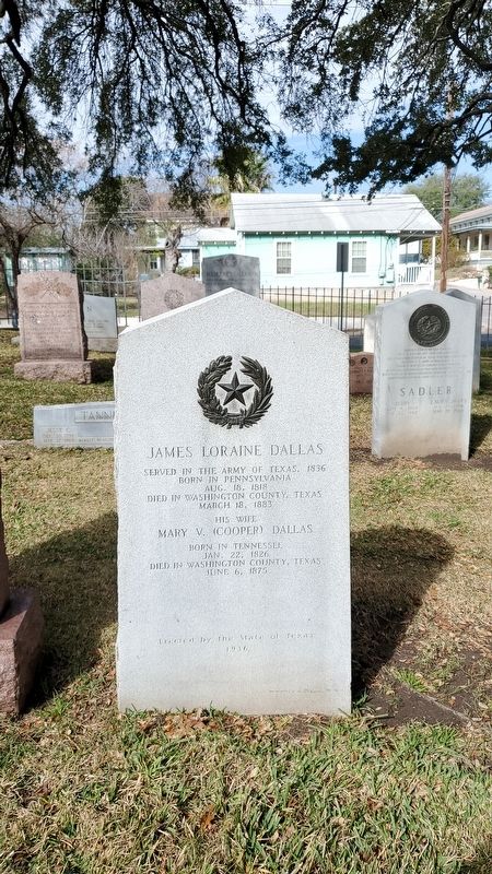
Near Navasota Street at Inks Avenue, on the right when traveling north.
Served in the Army of Texas, 1836 · Born in Pennsylvania Aug. 18, 1818 · Died in Washington County, Texas March 18, 1883 His wife Mary V. (Cooper) Dallas · Born in Tennessee Jan. 22, 1826 · Died in Washington County, Texas June 6, 1875 — — Map (db m167064) HM
Near Park Road 12 0.5 miles east of Farm to Market Road 1155.
In 1960, 28-year-old Gus F. Mutscher was elected State Representative from Washington County, Texas. In 1965, he introduced a bill appropriating $800,000 for construction of a "Worthy Museum, at the Birthplace of Texas that would be a Star upon a . . . — — Map (db m217338) HM
On Congress Avenue just south of East 18th Street.
The initiator of Anglo-American settlement in Texas. Moses Austin was a native of Durham, Connecticut. After his marriage to Mary Brown in 1785, Austin became a leading figure in the development of the American lead industry. His business took him . . . — — Map (db m158896) HM
On Park Road 12, on the right when traveling west.
To the memory of
those courageous souls,
the delegates to the
Constitutional Convention
held here March 1-17, 1836
who declared Texas free,
organized a Republic, and
framed its constitution
Jessie B. Badgett
Dr. George . . . — — Map (db m131017) HM
Near Boonville Road (Farm to Market Road 158) 0.1 miles east of Austins Colony Parkway.
The State of Texas consists of 254 counties. Washington County, with its settlements of Independence and Washington on the Brazos, was one of the 23 counties created in 1836 following Texas independence. Most of the area of present day Brazos . . . — — Map (db m170365) HM
On State Highway 14 0.5 miles north of County Highway 662, on the right when traveling north.
The Brown Family Cemetery traces its origin to the settlement of North Carolina native Ervin Brown (1801 1875) and his wife Matilda (1807-1871) in Washington County, Texas. In 1846, Ervin and Matilda moved their family to a 1600 - acre farm, in . . . — — Map (db m159060) HM
On Farm to Market Road 1603 at Rice Road on Route 1603.
Chatfield, a prosperous farming community, was the site of the organization of the Baptist General Association of Texas on July 17, 1868. Originating in the mid-1840s as a trading post established near a spring by Indian trader Norman Chatfield, it . . . — — Map (db m217188) HM
The congress of the Republic of Texas, meeting at Washington-on the-Brazos, chartered Baylor University on February 1st, 1845. The idea of a Baptist university in Texas originated with William Milton Tryon, who with Robert Emmett Bledsoe Baylor, . . . — — Map (db m166758) HM
On County Route 203 at Peaceful Valley Road, on the right when traveling west on County Route 203.
Alabama native Sampson Connell, Jr. (b. 1822) came to Texas with his family in 1834. Sampson, his father, and his brother participated at the Battle of San Jacinto in 1836. For his efforts, Sampson received a land grant in Washington County. He . . . — — Map (db m92902) HM
Near Farm to Market Road 183 0.7 miles south of U.S. 84, on the left when traveling south.
John Raney Bertrand was born in Brazoria County, the son of French immigrants who came to Texas before the Texas Revolution. He was a partner in a mercantile business in Washington County for several years before leaving to join the Confederate Army . . . — — Map (db m217408) HM
Near Navasota Street at East 8th Street, on the right when traveling north.
William Carey Crane, Born In Richmond Va. March 17, 1816. Died in Independence Tex. Feb. 27, 1885. He gave his life to the cause of education and religion in Ga. Ala. Miss. La. and Texas. The remains of Dr. Crane were removed from Washington . . . — — Map (db m168016) HM
On Waters Lane at Old Baylor College Road, on the left when traveling west on Waters Lane.
A native of North Carolina, John Prince Coles brought his family to Texas in 1821 with Stephen F. Austin's "Old Three Hundred" colonists. Arriving in present Washington County on New Year's Day in 1822, Coles received a Mexican land grant . . . — — Map (db m156743) HM
Near Park Road 12 0.5 miles east of Farm to Market Road 1155.
Government and the river brought new life to Washington.
The Republic of Texas made Washington the capital in 1842. Washington became the new home of Texas' Congress, courts and administrative offices. The growth attracted new residents . . . — — Map (db m217254) HM
On West Buck Street south of South Main Street (Loop State Highway 83), on the right when traveling west.
In rich Brazos River basin; had settlers early as 1825. Site in 1830 of Tenoxtitlan, one of 3 forts built by Mexico in Texas, situated above El Camino Real (The King's Highway) crossing on Brazos River. North of the road was Sterling Robertson's . . . — — Map (db m201845) HM
On Farm to Market Road 1363 0.1 miles east of Front Street (County Highway 315), on the right when traveling west.
A leader in Texas colonization, Alexander Thomson, Jr., was born in St. Matthew's Parish, South Carolina, the only son of Alexander and Lucy (Fontaine) Thomson. He later lived in Georgia before moving to Tennessee. There, in 1830, he became a . . . — — Map (db m210613) HM
David Finney Stuart was born in Brooke County, Western Virginia, to William and Mary Cummins Stuart. Upon the death of his parents, Stuart moved to Texas to live with his sister Elizabeth, wife of the Rev. Dr. James Weston Miller. A brother-in-law, . . . — — Map (db m122989) HM
On East Main Street (Business U.S. 290), on the left when traveling west.
Washington County was the most populous in the state during the Civil War. It served as a center for production, warehousing, transportation, communications, and had a large quartermaster depot. Local wartime factories made spinning jennies, lumber, . . . — — Map (db m125650) HM
On Century Circle at Heritage Drive, on the left when traveling west on Century Circle.
This grand structure is one of the top ten examples of Greek Revival residential architecture in Texas. This was the second home of Honorable J.D. Giddings, Brenham's most prominent forefather, and his wife, Ann. An architectural feat, the . . . — — Map (db m165119) HM
On South Missouri Street just south of West High Street (State Route 8), on the right when traveling south. Reported missing.
The silent stones of the front foundation wall are all that remain of Durham Hall, a magnificent frontier mansion built here by Moses Austin in 1798-1799.
Named for Durham, Connecticut, where Austin was born in 1761, the home was the . . . — — Map (db m307734) HM
Near Lt Billy Webb Avenue 0.1 miles north of Cook Street. Reported unreadable.
In the years preceding the war with Mexico, the United States and Mexico were two nations headed in opposite directions.
The United States, inspired by the concept of “Manifest Destiny,” confidently expanded its territories westward. Meanwhile, . . . — — Map (db m231522) HM
A member of Stephen F. Austin's Colony, George Washington Gentry came to Texas in 1835 with his father and brother. Settling what is now Washington County, he worked as a farmer and surveyor. He participated in the Texas Revolution, several Indian . . . — — Map (db m158029) HM
A veteran of the War of 1812, David Ayers brought his family to Texas in 1833. On behalf of the American Bible Society, they distributed bibles to new settlers. Settling first in San Patricio, Ayers moved to Washington County, where he became a . . . — — Map (db m127585) HM
On South Main Street (U.S. 77) at East Richmond Street, on the right when traveling north on South Main Street.
County seat of Lee County. Named for Jabez D. Giddings (1814-78), of Washington County, one of four brothers from Pennsylvania who were Texas transportation pioneers and business leaders.
The town was established as a shipping point when . . . — — Map (db m150321) HM
Near MP Daniel Esplanade at South 5th Street, on the right when traveling north.
World's largest Baptist University. Founded under charter issued by Congress of Republic of Texas on Feb. 1, 1845, and in continuous operation ever since.
Named for Judge R. E. B. Baylor (1791-1873), a native of Kentucky, an 1820s United . . . — — Map (db m180289) HM
Rebecca Jane Kilgore Stuart became principal of Live Oak Female Seminary in Washington County, Texas, in 1853. In 1854 she married Dr. George Clark Red and continued teaching. The Reds moved to Austin in 1876, and opened Stuart Female Seminary at . . . — — Map (db m26346) HM
On Old Masonic Cemetery Road (County Highway 56) 0.1 miles north of Duprie Drive, on the right when traveling north.
Numerous gravestones dating from the early 1840s indicate that this burial ground was in use well before December of 1847, when it was formally deeded to the Graham Masonic Lodge #20 by Chauncey B. Shepard (1812-1892). Brenham's citizens buried . . . — — Map (db m164537) HM
On State Highway 36 south of Jungle Lane, on the right when traveling north.
A native of North Carolina, Robert Starke Armistead moved with his family to Alabama in 1818. He married Ann Sylvesta Carney in 1826 and they came to Texas in 1835. Armistead served in the Republic of Texas army in 1836 and with forces defending San . . . — — Map (db m125651) HM
On Farm to Market Road 1155 0.6 miles south of Farm to Market Road 2193, on the left when traveling north.
When Texas seceded from the Union on March 2, 1861, and became part of the Confederate States of America, Confederate training grounds and Union prisoner of war camps were established in the area. Camp Felder was established as a cavalry base . . . — — Map (db m217120) HM
Near Buchanan Drive (State Highway 29) at Fort Croghan Drive.
One of "Old 300" of Stephen F. Austin's first colony from Pennsylvania, took part in 1836 War for Texas Independence, he made and lost several stakes.
In 1851 bought a league and labor of Burnet County land, including site of Fort Croghan. . . . — — Map (db m29150) HM
On Ebenezer Cemetery Rd (County Road 714) 1 mile south of State Highway 7, on the right when traveling south.
James A. Head was a Texas Ranger, veteran of the War for Independence, and Republic of Texas legislator. Born in Georgia in 1797, he moved to Texas in 1835, enlisting at San Felipe de Austin in Silas Parker's ranging company and securing a land . . . — — Map (db m293422) HM
On Wesley Church Lane 0.4 miles south of Farm to Market Road 2502, on the left when traveling south.
Austin County Historic School Site This was the location of: Wesley School 1863 - 1900 An early Austin County School, this plaque commemorating this historic site was made possible by citizens of Austin County under sponsorship of Austin . . . — — Map (db m165434) HM
On Market Street at South Elm Street, on the right when traveling east on Market Street.
Harris County was 1861 center for 492 miles of state railroads, with Texas & New Orleans going from here to Orange; Houston & Texas Central to Millican; Houston Tap & Brazoria to Columbia; Buffalo Bayou, Brazos & Colorado to Alleyton; and . . . — — Map (db m170799) HM
On State Highway 7 at Ebenezer Church Road (County Highway 462), on the right when traveling east on State Highway 7.
Bardin King (1819-1891) and Elizabeth Susan Salter (1822-1879) married in Lowndes County, Alabama in 1842. The following year, they traveled west by wagon with their young son William and Susan’s parents and siblings, settling in Louisiana. Bardin . . . — — Map (db m156969) HM
On Century Circle at Heritage Drive, on the left when traveling west on Century Circle.
This house was completed in 1870 for prominent Brenham banker, lawyer, and landowner Jabez Giddings (1814-1878) (for whom Giddings, Texas, is named) and his wife Ann (1822-1902). It was later owned by their daughter, Mary Louise, and her husband, . . . — — Map (db m165118) HM
Near Poplar Street at Church Street, on the right when traveling east.
Chappell Hill Male and Female Institute (founded 1850) pioneered in higher learning in Texas. Under Methodist Church after 1854. Women's branch was chartered separately, 1856. Rebuilt after a fire in 1871; this bell, cast 1873, is only relic of . . . — — Map (db m165003) HM
Near Park Road 12 1 mile Farm to Market Road 1155.
This is the birthplace of the Independent Republic of Texas. The words written here changed the course of history. The building you're looking at is a replica of the original Texas Independence Hall. It was an unfinished storefront that housed . . . — — Map (db m217148) HM
Near Park Road 12 5 miles east of 23400 Park Road 12.
On This Spot
Was Made
The Declaration
of Texas
Independence
March 2, 1836
The Necessity of Self-Preservation Therefore, Now Degrees Our Eternal Political Separation — — Map (db m217168) HM
Near Park Road 12 0.5 miles east of Farm to Market Road 1155.
When delegates met here in 1836 to declare independence, Washington was a new and tiny town.
In 1836 Washington was a small community built around a ferry landing where the La Bahia Road crossed the Brazos River. It had good water from . . . — — Map (db m217170) HM
Near Park Road 12 0.5 miles east of Farm to Market Road 1155.
Sticking with ferries meant Washington missed the boat.
The Brazos River was Washington's lifeline during the 1840s and 1850s. The town was as far up the river as boats could reliably travel. Riverboats brought goods from Galveston, New . . . — — Map (db m217263) HM
Near Park Road 12 0.5 miles east of Farm to Market Road 1155.
An original resident of Washington still survives.
This tree has seen the Texas Revolution, and the birth and decline of Washington. But the towering pecan tree isn't a native Texan. It's a product of the same forces that drove . . . — — Map (db m217275) HM
On Farm to Market Road 2502 0.1 miles north of Farm to Market Road 332, on the right when traveling south.
Czech immigrants came to this area in 1859 and renamed it Wesley community. Professor Josef Masik tutored children in his home. The Bohemian Slovakian Reading Club of Wesley provided the first area school building about 1863. School was taught in . . . — — Map (db m165385) HM
On Farm to Market Road 539 0.2 miles south of Polly Lane, on the left when traveling north.
Joseph Henry Polley (1795-1869) was born in Whitehall, New York to Jonathan and Rachel Hubbard Polley. He later moved to Missouri, where he was a friend of Moses Austin, with whom he traveled to Texas in 1820. The next year, he returned to Texas . . . — — Map (db m167557) HM
In Late March 1836, the Texian Army was in retreat ahead of Santa Anna's advancing Mexican forces. The retreat spurred the "Runaway Scrape" - a wave of settlers fleeing for their lives. To prevent the enemy from benefitting from San Felipe's . . . — — Map (db m206186) HM
With his Empresario contract in hand, Stephen F. Austin searched out a suitable location for the "capital" of his colony. Together with surveyors and guides, Austin selected a site where a ferry crossed the Brazos River. By late October . . . — — Map (db m206331) HM
Near East 26th Street at North Washington Avenue, on the right when traveling west.
Brazos County, part of Stephen F. Austin’s colony, was created from Washington County in 1841. It was first named Navasota County, with Boonville as the county seat. In 1842 the name was changed to Brazos County. Through the Civil War, Millican, . . . — — Map (db m119591) HM
On West Buck Street at South Main Street (Loop State Highway 83), on the right when traveling west on West Buck Street.
In 1840 the Republic of Texas Congress annexed to Milam County all of Washington County north of Yegua Creek and west of the Brazos River. The name Caldwell, which honored Mathew "Old Paint" Caldwell, a noted pioneer and a signer of the Texas . . . — — Map (db m125666) HM
Near North Street (Business U.S. 59) north of Griffith Boulevard, on the right when traveling north.
Republics often point to one person whose vision and leadership led to their creation. For the Republic of Texas (1836-1845) that person is Stephen Fuller Austin.
Austin, the son of Moses and Maria Brown Austin, was born on the Virginia . . . — — Map (db m313281) HM
On Waul's Legion Road (County Road 51) 1 mile west of State Highway 36, on the left when traveling west.
Born and educated in Scotland, Thomas Affleck (1812-1868) emigrated in 1832 to the United States, where he became one of the most well-known agriculturalists of his time. A prolific writer, Affleck was associated with several agricultural and . . . — — Map (db m28316) HM
On Old Baylor College Road at Waters Lane on Old Baylor College Road.
The Independence Historical Society moved the Coles Cabin and Independence Log House buildings to this site to ensure their preservation.
"Walking through the house, we can visualize Coles (with his spectacles on his forehead) conducting . . . — — Map (db m157275) HM
On W Buck Street at S Hill Street, on the right when traveling south on W Buck Street.
Founded 1840 by Lewis L. Chiles, a veteran of Battle of San Jacinto. Named for Mathew "Old Paint" Caldwell, Indian fighter and signer of the Texas Declaration of Independence. This was county seat, Milam County, in 1845; since 1846 county seat of . . . — — Map (db m286766) HM
On West Buck Street at South Moore Street, on the right when traveling west on West Buck Street.
This congregation was organized by the Rev. Hugh Wilson, an early Presbyterian missionary noted for his active work on the Texas frontier. Although the first account of the church appears in an 1850 document, it is likely that the congregation was . . . — — Map (db m204236) HM
On County Highway 271 0.5 miles north of Farm to Market Road 60, on the right when traveling north.
Prussian born Johann Joachim Giesenschlag (1817-80), his wife Anna (Schulze), and their children came to Texas in 1855. Settling first in Washington County, they moved to Burleson County in the 1870s and bought over 1,000 acres here. Giesenschlag . . . — — Map (db m220041) HM
Near Landa Park Drive at Monument Drive, on the right when traveling north.
Panel 1
The first German settlements in Texas were Industry in Austin County, founded by Friedrich Ernst in 1831, Biegel in Fayette County, founded by Joseph Biegel in 1832, Cat Spring in Austin County, founded by the von Roeder, Kleberg, . . . — — Map (db m210312) HM
Near Speight Avenue east of South 7th Street, on the left when traveling east.
Old Main, completed in 1887, was the first building constructed on the Baylor Campus after the university's move from Independence, Washington County. Because of Baylor's limited resources, the building served as the primary location for both . . . — — Map (db m183666) HM
On East 9th Street at Navasota Street, on the right when traveling west on East 9th Street.
After 23 years as principal of Live Oak Female Seminary, Washington County, Rebecca K. Stuart Red (1826-1886) founded her own school in 1875. Her husband, G.C. Red, M.D., had a two-story stone dormitory – academic building erected on this . . . — — Map (db m26608) HM
On Boehenmann Road (County Highway 19) 1 mile west of Farm to Market Road 389, on the right when traveling west.
Located on land granted to Josiah Lester by the Mexican government prior to Texas independence, this cemetery began in the 1850s after subsequent landowner Erwin Brown set aside land for a school and church. The site also served as a community . . . — — Map (db m165382) HM
On Cottonwood Street at Botts Street, on the right when traveling north on Cottonwood Street.
Organized with 18 members in 1877, this congregation grew out of the early missionary efforts of A.J. Bush and W.J. Jones. Many prominent Washington County settlers were among its earliest members. The fellowship worshiped at various locations . . . — — Map (db m165254) HM
On Crockett Street 0.1 miles east of Gay Hill Street, on the right when traveling west.
Jabez Deming Giddings (1814-1878) of Pennsylvania bought this land in 1837. A lawyer, businessman, and civic leader, he built this residence of hand-hewn cypress boards before his marriage in 1843 to Ann Tarver (1822-1907). An unusual rooftop . . . — — Map (db m165316) HM
Historic Beginnings
A heated exchange between Union soldiers and local citizens in September 1866 led to the eventual development of the City of Brenham's flagship park. The soldiers, part of an infantry company, took issue with comments . . . — — Map (db m171633) HM
On State Road 53 at Airville Road, on the left when traveling east on State Road 53.
Jan Zabcik Sr. (1810–1881), his wife, Anna Hruska (1825–1900), and daughters Johanna and Katerina traveled to Galveston, Texas from Moravia in 1856 along with Jan’s brother, Martin Zabcik, and sister, Anna Zabcik. Once in Texas, the Zabciks made . . . — — Map (db m290683) HM
On Loop State Highway 540 at South 4th Street, on the left when traveling west on State Highway 540.
Founded 1894 by Cecil A. Beasley (1862 - 1908), on the Texas & New Orleans Railroad. First called "Dyer" for Isabel Dyer (1871 - 1933), whom Beasley later married. Post office opened as "Beasley," May 13, 1898. The town boomed in 1910, as Stern & . . . — — Map (db m168553) HM
On South Main Street (Loop State Highway 429) at West Buffington Avenue, on the left when traveling south on South Main Street.
On road used 1690 by Spanish explorer Alonso de Leon. In 1821 Andrew Millican began settlement. Henry Fanthorp opened his inn 1834, a post office 1835. Kenneth Anderson, last Vice-President, Republic of Texas, died at Fanthorp's, 1845. After his . . . — — Map (db m118977) HM
On Church Street at Johnson Street, on the left when traveling north on Church Street.
Born in Amelia County, VA. The Neal family moved to Washington County, Texas, in 1866. Neal, after attending Baylor University, was admitted to the Bar in 1876. He married Fannie C. Brooks in Oct. 1880, moved to Navasota in 1881, and purchased this . . . — — Map (db m213690) HM
On State Road 21 3.1 miles west of Old San Antonio Road, on the right when traveling east.
A fur trapper by trade, Daniel Larrison was an early Anglo Texas settler who received a Mexican Land Grant in 1833, which included the area later organized as Madison County. Born in Washington County, Pennsylvania, Larrison served under Zachary . . . — — Map (db m268125) HM
On North Memorial Street (State Highway 6) at East Frederick Street, on the left when traveling north on North Memorial Street.
Fertile soil, good water, and available rail transportation attracted cotton farmers to this area after the Civil War. They were soon joined by German settlers from Washington County led by the Rev. Friedrick von Schleumbach. A nearby postal station . . . — — Map (db m208793) HM
On 124 near County Road 248, on the left when traveling north.
Panola County pioneer Isaac R. Youngblood was born about 1793. Не and his wife, Elizabeth, moved to Texas from Washington County, Georgia, before 1846. In 1847 the county commissioners named him overseer of Grand Bluff Road and part of a . . . — — Map (db m268526) HM
Near Locust Street at Main Street (Business U.S. 82).
During the 4 years, 4 months after secession, Texas sent 18 lawmakers to the Confederate capitols. Her delegates to the Provisional Congress, Feb. 1861 to Feb. 1862, were John R. Gregg, Freestone County; John Hemphill, Travis County; Wm. B. . . . — — Map (db m96899) HM
On West Alamo Street at Joseph Street, on the left when traveling east on West Alamo Street.
In 1914, noted Texas educator Columbus H. Hogan became a founding partner in the Washington County Undertaking Co. on South Park Street in Brenham. It was then the only funeral home in the county for African Americans. Hogan later became sole . . . — — Map (db m165377) HM
On West High Street (Missouri Route 8) at South Missouri Street, on the right when traveling east on West High Street.
Early mining center, named for the famous South American silver mine, Potosi was established by Moses Austin as the seat of Washington County, organized, 1813.
Austin came here, 1797, after receiving a 3 square mile Spanish land grant, including . . . — — Map (db m119802) HM
On Sempronius Road at Phillipsburg Church Road, on the left when traveling west on Sempronius Road.
In 1890, Phillipsburg residents formed the St. Paul Lutheran Church. Later that year, Henry Stern deeded eight acres of land for a church and school and one acre for a cemetery. The first burial is that of the infant son of Mr. and Mrs. Carl . . . — — Map (db m202575) HM
Born to Cyrus C. Campbell (1810-1883) and Rebecca Elizabeth Robbins (1818-1846), Cyrus Maxwell Campbell was raised near Travis (Austin County). At the age of 21, he enlisted in the Confederate Army at the beginning of the Civil War, serving in the . . . — — Map (db m207091) HM
On County Road 344 near Highway 3442, on the left when traveling west.
This church reflects the rich German heritage of this area of Hill County. German immigrants, who settled first in Washington County, began moving here in the 1880s. On June 6, 1886, fifteen families joined together to organize the Salem Lutheran . . . — — Map (db m289834) HM
On Farm to Market Road 531 0.2 miles south of Alternate U.S. 77, on the left when traveling north.
Stephen Bennett (1789-1874), a veteran of the War of 1812, and his wife Mary Ann "Polly" Breazeal Bennett (1798-1877), were born in South Carolina and lived many years in Alabama. They led a wagon train to Washington County in the Republic of . . . — — Map (db m291837) HM
On East Stone Street at South Market Street (Business U.S. 290), on the left when traveling east on East Stone Street.
Established in 1844 Named in honor of Dr. Richard Fox Brenham 1810 - 1843 Surgeon in the Army of the Republic of Texas Member of the Mier Expedition Killed at Salado, Mexico February 11, 1843 — — Map (db m241021) HM
On Crockett Street 0.1 miles east of Gay Hill Street, on the right when traveling west.
This is the oldest standing structure in Brenham. It was the second house built in Hickory Grove, as Brenham was called in those days. This was the first home built by Honorable J.D. Giddings, Brenham's most prominent forefather. It was a . . . — — Map (db m165317) HM
On West Third Street at South Day Street, on the left when traveling west on West Third Street.
German immigrants began settling in Washington County in the 1840s. The first German Lutheran congregation began in 1855 in the community of Berlin. The growing German Lutheran community in Brenham organized this congregation, first known as the . . . — — Map (db m165132) HM
On East Alamo Street (Business U.S. 290) at South Baylor Street, on the left when traveling east on East Alamo Street.
Composed of a chief justice (now county judge) and four county commissioners, these elected governing boards directed vital Civil War programs. Provided arms, clothing, horses and saddles for troops from county. Gave aid to wartime factories. . . . — — Map (db m125649) HM
On East Main Street (Business U.S. 290) west of South Baylor Street, on the left when traveling west.
Built in 1940 with funds granted by the Public Works Administration, this is the fourth courthouse to serve Washington County since its formation in 1835. Constructed during the tenure of County Judge Sam Low, the massive white limestone . . . — — Map (db m111920) HM
The Baylor trustees began construction on Main Building in 1860. Onset of the Civil War and financing problems halted work. A one-story shell of stone remained untouched until sufficient fund were attained to resume construction in 1880. Also . . . — — Map (db m164165) HM
On Flat Prairie Road (County Highway 112) 1 mile east of Farm to Market Road 2726, on the right when traveling east.
Reverend J.L. Lawson and community members organized the Mercy Seat Baptist Church in 1894. Located in what was then called Graball, the original church building was built on property south of the current location. In 1953, the membership voted to . . . — — Map (db m217121) HM
On Alexander Road 1 mile west of Farm to Market Road 974.
There was a schoolhouse near this site in 1854 when, according to tradition, the first interment was made here. That early grave, for a child by the name of Whitley, had no marker and has been lost.
This land was part of a one-league headright . . . — — Map (db m292078) HM
On County Highway 225 0.2 miles north of County Highway 208, on the left when traveling north.
About 1870 this area of Burleson County was settled by Czech-Moravian immigrants in search of fertile land and the religious freedom denied them in their native European homeland. Informal services were held twice a year in the family home of Joseph . . . — — Map (db m220013) HM
On Thornberry Drive at 8th Street, on the right when traveling east on Thornberry Drive.
First shovel of earth for Somerville Dam was turned Sept. 22, 1962, by Lyndon B. Johnson then Vice President of United States.
Dam was built to control flooding on Yegua Creek in the 46 years prior to 1958, Yegua had flooded 43 times, costing . . . — — Map (db m203943) HM
On 8th Street at Avenue L, on the right when traveling south on 8th Street.
As the Somerville Independent School District (SISD) emerged from the great depression, the school board filed a Works Progress Administration project proposal on October 3, 1938, to build a gymnasium. The proposal was accepted and construction on . . . — — Map (db m203941) HM
On Farm to Market Road 1772 0.2 miles south of State Road 53, on the right when traveling south.
The town of Barclay was founded in 1877 when William Anderson Barclay (1849-1927) opened a general mercantile store here. A leader in farming, business, commercial, and industrial circles throughout central Texas, W.A. Barclay also operated a large . . . — — Map (db m290656) HM
On Harbor View Boulevard at Tri City Beach Road, in the median on Harbor View Boulevard.
Once located southwest of this site was the home of Henry Falvel Gillette (1816-1896). A native of Connecticut, Gillette came to Texas in 1840 at the urging of his cousin, Ashbel Smith. He became a noted educator in Harris, Washington, and Polk . . . — — Map (db m53615) HM
On Mt. Olive Street 0.1 miles south of State Highway 105, on the right when traveling east.
Brenham’s African American and Anglo community leaders first discussed the Brenham Normal and Industrial College (BNIC) in a public meeting in March 1905, when Daniel Porter (1863-1916) came to the area seeking land and a building to create a . . . — — Map (db m131045) HM
On Farm to Market Road 390 south of Longpoint Road, on the right when traveling west.
As a boy Gideon Lincecum moved with his father to various frontier sites in his native Georgia and in Mississippi. It was during this time that he developed insights about natural habitats and cultivated an understanding of Indian culture which . . . — — Map (db m93501) HM
The Methodist church established four colleges in Texas prior to the Civil War: Rutersville College (1840), Wesleyan College (1844), McKenzie Institute (1848), and Soule University (1856). The Rev. Dr. Francis Asbury Mood (1830-1884) was named . . . — — Map (db m4909) HM
On Lakeview Parkway near Shoosmith Road, on the left when traveling north.
During the first 18 months of the Civil War, President Abraham Lincoln chose not to act upon recommendations of Frederick Douglass, and others, to enlist Black men in the Union Army in the fight against the Confederacy. After the much-needed Union . . . — — Map (db m314862) HM
On Charles Street at Sumans Avenue, on the left when traveling west on Charles Street.
The Robert Moxley Band was a group of African-American musicians, mostly local slaves, who formed a military-style brass band in the years before the Civil War. The band held regular concerts in what is now Jacob Wheaton Park. In 1863 the U.S. . . . — — Map (db m107363) HM
On Farm to Market Road 1094 at Swearingen Road, on the right when traveling west on Highway 1094.
Austin County pioneer and Texas War for Independence veteran, Elemelech Swearingen, was born in Shepherdsville Kentucky (Bullitt Co.) in 1805. He married Angelina Weeks (1811-1883) in 1827 and in 1831, moved with his family to Texas. The Swearingens . . . — — Map (db m202526) HM
Near Navasota Street near East 7th Street, on the right when traveling north.
A veteran of the War of 1812
Internationally famous botanist
Friend of Darwin
Born in Georgia
Died at Long Point
Washington County, Texas
November 28, 1873 — — Map (db m74930) HM
On Main Street (Farm to Market Road 1155) north of Cedar Street, on the right when traveling south.
Chappell Hill began as an agricultural community in 1847 but had no bank until a population boom in the early 1900s brought wealth and economic prosperity.
Farmers State Bank organized in March 1907 and opened in September of that year with J. . . . — — Map (db m111933) HM
Sacred
to the memory of
Mrs. Eliza M.
The wife of
Lieut. W. E. Jones,
U.S. Mounted Rifles.
She was born on the 3rd of May 1884 in Washington County, Virginia, was married on the 15th of January 1852, and was drowned on the 26th . . . — — Map (db m20414) HM
A native of Scotland, Alexander Beaton came to the United States in 1843. He migrated to Texas in 1848 after serving in the U.S. Army during the Mexican War. In 1850 he settled in Corsicana and began the practice of law. He was chairman of the . . . — — Map (db m60493) HM
"It turned out that a traveling carnival had set up there several years earlier and then didn't make enough money to pay the rent for the pasture. So they just left their 24-horse Carousel there. We got those hobby horses for a very reasonable . . . — — Map (db m177280) HM
Thin black lines indicate changes in relevance. Between each pair of lines entries are ordered geographically but all have the same relevance.
* Inflectional forms of words are their plurals, singulars, and possessives as well as gramatical tenses and similar variations.