4096 entries match your criteria. Entries 101 through 200 are listed.⊲ Previous 100 — Next 100 ⊳
Historical Markers and War Memorials in Kentucky
By Tom Bosse, November 4, 2017
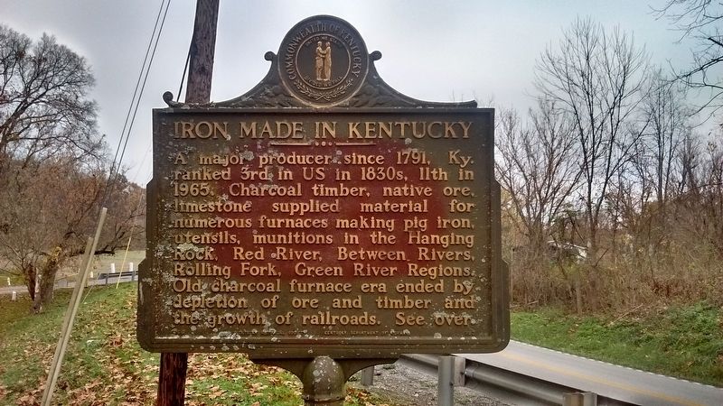
Iron Made in Kentucky Marker
| 101 ► Kentucky, Bath County, Owingsville — 993 — Bourbon Iron Works / Iron Made in Kentucky — |
| On Kentucky Route 36, on the left when traveling north. | |||
| 102 ► Kentucky, Bath County, Owingsville — 1528 — Capt. John “Jack” Jouett, Jr. — |
| Near West Main Street (U.S. 60). | |||
| 103 ► Kentucky, Bath County, Owingsville — 592 — Courthouse Burned — |
| Near West Main Street (U.S. 60). | |||
| 104 ► Kentucky, Bath County, Owingsville — 862 — Gen. Hood Birthplace — |
| On East Main Street (U.S. 60), on the right when traveling west. | |||
| 105 ► Kentucky, Bath County, Owingsville — 1193 — Owings House / Thomas Dye Owings — |
| On West Main Street, on the left when traveling west. | |||
| 106 ► Kentucky, Bath County, Salt Lick — 1050 — Clear Creek Furnace / Iron Made in Kentucky — |
| On Main Street (Kentucky Route 211), on the right when traveling north. | |||
| 107 ► Kentucky, Bath County, Salt Lick — Unwind with Us — Cave Run Lake Country — |
| On Main Street (Kentucky Route 211), on the right when traveling north. | |||
| 108 ► Kentucky, Bath County, Sharpsburg — 2509 — Henry Tureman Allen — |
| On Camp Street, on the right when traveling south. | |||
| 109 ► Kentucky, Bell County, Clear Creek Springs — First Camp Site In Kentucky — |
| On Paula Drive (County Road 190) just west of U.S. 25E, on the right when traveling west. | |||
| 110 ► Kentucky, Bell County, Clear Creek Springs — 1286 — Henderson Settlement — Settlement is 17 miles west on Ky 190 — |
| On State Highway 190 at U.S. 25E, on the right when traveling east on State Highway 190. | |||
| 111 ► Kentucky, Bell County, Ewing — Indian Rock — |
| Near Pinnacle View Road, 0.7 miles south of Kentucky Route 986, on the right when traveling south. | |||
| 112 ► Kentucky, Bell County, Middlesboro — "This American Gibraltar" — |
| Near Pinnacle Road, on the right when traveling east. | |||
| 113 ► Kentucky, Bell County, Middlesboro — 521 — A Masterful Retreat — |
| Near Old Wilderness Road (Kentucky Route 988) at Pinnacle View Road, on the right when traveling north. | |||
| 114 ► Kentucky, Bell County, Middlesboro — An Object Lesson Road — Cumberland Gap National Historical Park — National Park Service, U.S. Department of the Interior — |
| Near Sugar Run Overlook Road (Kentucky Route 988). | |||
| 115 ► Kentucky, Bell County, Middlesboro — An Object Lesson Road — Cumberland Gap National Historical Park — National Park Service, U.S. Department of the Interior — |
| Near Sugar Run Overlook Road (Kentucky Route 988). | |||
| 116 ► Kentucky, Bell County, Middlesboro — 129 — Colonel Arthur Campbell — |
| On North 24th Street at Gloucester Avenue, on the right when traveling north on North 24th Street. | |||
| 117 ► Kentucky, Bell County, Middlesboro — Community Park to National Park — Cumberland Gap National Historical Park — |
| Near Bartlett Park Road, 0.4 miles south of Pinnacle View Road, on the right when traveling south. | |||
| 118 ► Kentucky, Bell County, Middlesboro — 2450 — Cumberland Gap / Grant Visits Cumberland Gap — |
| Near Old Wilderness Road (Kentucky Route 988) at Pinnacle View Road, on the right when traveling north. | |||
| 119 ► Kentucky, Bell County, Middlesboro — Daniel Boone Trail — |
| On Wilderness Road Trail. | |||
| 120 ► Kentucky, Bell County, Middlesboro — Daniel Boone's Trail — |
| Near Wilderness Road Trail. | |||
| 121 ► Kentucky, Bell County, Middlesboro — Daniel Boone's Trail — |
| On Wilderness Road Trail. | |||
| 122 ► Kentucky, Bell County, Middlesboro — Defense of the Gap |
| Near Pinnacle Road, on the right when traveling east. Reported permanently removed. | |||
| 123 ► Kentucky, Bell County, Middlesboro — Dirt-and-Log Forts — Cumberland Gap National Historical Park |
| On Pinnacle View Road, 1.7 miles east of Kentucky Route 988. Reported missing. | |||
| 124 ► Kentucky, Bell County, Middlesboro — Dirt-and-Log Forts — Cumberland Gap National Historical Park — |
| Near Pinnacle View Road, 1.7 miles east of Old Wilderness Road (Kentucky Route 988), on the left when traveling east. | |||
| 125 ► Kentucky, Bell County, Middlesboro — Forts and Batteries, North and South — Cumberland Gap National Historical Park — |
| Near Pinnacle View Road, 1.1 miles east of Old Wilderness Road (Kentucky Route 988), on the right when traveling east. | |||
| 126 ► Kentucky, Bell County, Middlesboro — Gateway to Kaintuck — |
| On Pinnacle Road, on the right when traveling east. | |||
| 127 ► Kentucky, Bell County, Middlesboro — Gateway to Kaintuck — Cumberland Gap National Historical Park — |
| On Pinnacle View Road, 2.5 miles east of Old Wilderness Road (Kentucky Route 988), in the median. | |||
| 128 ► Kentucky, Bell County, Middlesboro — Gateway to Kaintuck — Cumberland Gap National Historical Park — National Park Service, U.S. Department of the Interior — |
| On Pinnacle View Road, 2.5 miles east of Old Wilderness Road (Kentucky Route 988), in the median. | |||
| 129 ► Kentucky, Bell County, Middlesboro — Invasion through the Gap |
| Near Pinnacle Road, on the right when traveling east. Reported permanently removed. | |||
| 130 ► Kentucky, Bell County, Middlesboro — Leave Nothing Useful Behind — Cumberland Gap National Historical Park — |
| On Wilderness Road Trail, on the left when traveling west. | |||
| 131 ► Kentucky, Bell County, Middlesboro — 2217 — Lewis and Clark in Kentucky Cumberland Gap — Cumberland Gap — |
| On U.S. 25E, on the right when traveling east. | |||
| 132 ► Kentucky, Bell County, Middlesboro — Middlesboro Country Club — |
| On Cirencester Avenue at North 28th Street, on the right when traveling west on Cirencester Avenue. | |||
| 133 ► Kentucky, Bell County, Middlesboro — 1262 — Middlesboro Golf Club — |
| Near North 28th Street, 0.2 miles north of Cirencester Avenue, on the left when traveling north. | |||
| 134 ► Kentucky, Bell County, Middlesboro — 2225 — Middlesboro Meteorite Crater Impact Site — |
| On 12th Street (U.S. 25E), on the right when traveling north. | |||
| 135 ► Kentucky, Bell County, Middlesboro — 832 — Middlesborough — |
| On North 20th Street south of Lothbury Avenue, on the right when traveling south. | |||
| 136 ► Kentucky, Bell County, Middlesboro — 1227 — Mountain Vision — |
| On Cumberland Avenue. | |||
| 137 ► Kentucky, Bell County, Middlesboro — 1228 — Oldest House — |
| On 19th Street (Route 2079) at Hurst Road, on the right when traveling north on 19th Street. | |||
| 138 ► Kentucky, Bell County, Middlesboro — Pinnacle of Perfection — Cumberland Gap National Historical Park — |
| 139 ► Kentucky, Bell County, Middlesboro — Pinnacle Overlook — |
| On Pinnacle Road, on the right when traveling east. | |||
| 140 ► Kentucky, Bell County, Middlesboro — Pinnacle Overlook — Cumberland Gap National Historical Park — |
| Near Pinnacle View Road, 2.5 miles east of Old Wilderness Road (Kentucky Route 988), in the median. | |||
| 141 ► Kentucky, Bell County, Middlesboro — St. Mary's Episcopal Church — |
| On Englewood Road, 0.2 miles west of North 20th Street, on the left when traveling west. | |||
| 142 ► Kentucky, Bell County, Middlesboro — Stories of a journey through the Wilderness, into Kentucke.. — |
| On U.S. 25 East, on the right when traveling east. | |||
| 143 ► Kentucky, Bell County, Middlesboro — The Emigrant's Dream — |
| On Pinnacle Road, on the right when traveling east. | |||
| 144 ► Kentucky, Bell County, Middlesboro — The Old Home Place — Cumberland Gap National Historical Park — |
| On Sugar Run Overlook Road (Kentucky Route 988), on the right when traveling north. | |||
| 145 ► Kentucky, Bell County, Middlesboro — Top Guns — Cumberland Gap National Historical Park — National Park Service, U.S. Department of the Interior — |
| Near Pinnacle View Road, 2.5 miles Old Wilderness Road (Kentucky Route 988) when traveling east. | |||
| 146 ► Kentucky, Bell County, Middlesboro — Tri - State Heroes — Desert Storm — Preserving World Peace — |
| On 20th Street. | |||
| 147 ► Kentucky, Bell County, Middlesboro — Two Armies, One Railroad — Cumberland Gap National Historical Park — |
| Near Pinnacle View Road, 1.1 miles east of Old Wilderness Road (Kentucky Route 988), on the right when traveling east. | |||
| 148 ► Kentucky, Bell County, Middlesboro — Two-Way Traffic — Cumberland Gap National Historical Park — National Park Service, U.S. Department of the Interior — |
| On Pinnacle Road, on the right when traveling east. | |||
| 149 ► Kentucky, Bell County, Middlesboro — Waiting for the Battle that Never Came |
| Near Pinnacle Road, on the right when traveling east. Reported permanently removed. | |||
| 150 ► Kentucky, Bell County, Middlesboro — Warriors' Path — Cumberland Gap National Historical Park — National Park Service, U.S. Department of the Interior — |
| Near Thomas Walker Trail, 0.2 miles east of Pinnacle View Road, on the right when traveling east. | |||
| 151 ► Kentucky, Bell County, Middlesboro — 1402 — Watts Furnaces / Iron Made in Kentucky — |
| On 12th Street (U.S. 25E) at 14th Street East, on the right when traveling south on 12th Street. | |||
| 152 ► Kentucky, Bell County, Middlesboro — Wilderness Road — Then and Now — Cumberland Gap National Historical Park — |
| Near Pinnacle View Road. | |||
| 153 ► Kentucky, Bell County, Pineville — Bell County War Dead Memorial — |
| On Kentucky Avenue. | |||
| 154 ► Kentucky, Bell County, Pineville — Chained Rock — |
| Near Chained Rock Road, 4 miles east of 382, on the right when traveling east. | |||
| 155 ► Kentucky, Bell County, Pineville — 1426 — Cumberland Ford — |
| On Bob Madon Bypass (U.S. 25E) at Pine Street (State Highway 66), on the right when traveling west on Bob Madon Bypass. | |||
| 156 ► Kentucky, Bell County, Pineville — Daniel Boone's Trail — |
| On Courthouse Square. | |||
| 157 ► Kentucky, Bell County, Pineville — 683 — Invasion and Retreat — |
| On State Park Road (Kentucky Route 382) west of Chained Rock Road, on the right when traveling north. | |||
| 158 ► Kentucky, Bell County, Pineville — 198 — Joshua Fry Bell — |
| On Kentucky Avenue at Pine Street (Kentucky Highway 66), on the right when traveling east on Kentucky Avenue. | |||
| 159 ► Kentucky, Bell County, Pineville — Mountain Gateway — |
| On Kentucky Avenue at Pine Street (Kentucky Highway 66), on the right when traveling east on Kentucky Avenue. | |||
| 160 ► Kentucky, Bell County, Pineville — 2045 — Naming of the Cumberland River — |
| On U.S. 25E, on the right when traveling north. | |||
| 161 ► Kentucky, Bell County, Pineville — The Wilderness Road — |
| On State Park Road (Kentucky Route 382), on the right when traveling north. | |||
| 162 ► Kentucky, Bell County, Pineville — 54 — The Wilderness Road — |
| On Bob Madon Bypass (U.S. 25E) south of Park Avenue, on the left when traveling south. | |||
| 163 ► Kentucky, Bell County, Pineville — 1272 — Wallsend Mine — |
| On Bob Madon Bypass (U.S. 25E) at Tennessee Avenue, on the right when traveling west on Bob Madon Bypass. | |||
| 164 ► Kentucky, Bell County, Pineville — Wilderness Road Cemetery — |
| On Asher-Clear Creek Road at U.S. 25E, on the right when traveling east on Asher-Clear Creek Road. | |||
| 165 ► Kentucky, Boone County, Bullittsburg — 2367 — Bullittsburg Baptist Church — |
| On Bullittsburg Church Road (Kentucky Route 8) near Interstate 275, on the left when traveling north. | |||
| 166 ► Kentucky, Boone County, Burlington — Burlington Methodist Church — Burlington Historic District — 1837 — |
| On North Jefferson Street at Gallatin Street, on the right when traveling north on North Jefferson Street. | |||
| 167 ► Kentucky, Boone County, Burlington — Burlington Presbyterian Church — Burlington Historic District — 1833 — |
| On North Jefferson Street at North Alley, on the right when traveling north on North Jefferson Street. | |||
| 168 ► Kentucky, Boone County, Burlington — Duncan House — Burlington Historical District — c. 1910 — |
| On Gallatin Street, on the right when traveling west. | |||
| 169 ► Kentucky, Boone County, Burlington — Erastus Tousey House — Burlington Historic District — c. 1822 — |
| On North Jefferson Street at North Alley, on the left when traveling north on North Jefferson Street. | |||
| 170 ► Kentucky, Boone County, Burlington — Foster-Sandford House — Burlington Historic District — c. 1831 — |
| On North Jefferson Street south of North Alley, on the right when traveling north. | |||
| 171 ► Kentucky, Boone County, Burlington — 2412 — From Craig’s Camp / To Burlington — |
| On Kentucky Route 18 at Kentucky Route 338, on the right when traveling west on State Route 18. | |||
| 172 ► Kentucky, Boone County, Burlington — 2415 — George Speri Sperti (1900-1991) / Boonetucky Farm — |
| Near Sperti Lane, on the right when traveling south. | |||
| 173 ► Kentucky, Boone County, Burlington — Historic Burlington, KY — The New County Seat — |
| Near Washington Street (Kentucky Route 18) at Jefferson Street, on the right when traveling west. | |||
| 174 ► Kentucky, Boone County, Burlington — Historic Burlington, KY — Settling In and Getting Around — |
| Near Washington Street (Kentucky Route 18) near Jefferson Street (Kentucky Route 338). | |||
| 175 ► Kentucky, Boone County, Burlington — Historic Burlington, KY — Making a Living... — |
| Near Washington Street (Kentucky Route 18) near Jefferson Street, on the right. | |||
| 176 ► Kentucky, Boone County, Burlington — Hogan House — c. 1860 — Burlington Historic District — |
| On North Jefferson Street (Kentucky Route 338) west of Temperate Street, on the right when traveling west. | |||
| 177 ► Kentucky, Boone County, Burlington — James Runyan House — Burlington Historic District — c. 1840 — |
| On North Jefferson Street north of North Alley, on the right when traveling north. | |||
| 178 ► Kentucky, Boone County, Burlington — Latimer-Walden House — Burlington Historic District — c. 1867 — |
| On Washington Street (Kentucky Route 18) at Union Square, on the right when traveling west on Washington Street. | |||
| 179 ► Kentucky, Boone County, Burlington — Mary Draper Ingles — |
| Near Taylor Drive north of Burlington Pike (Kentucky Route 18). | |||
| 180 ► Kentucky, Boone County, Burlington — Old Boone County Courthouse — Burlington Historic District — 1889 — |
| On Kentucky Route 18 at Kentucky Route 338, on the right when traveling west on State Route 18. | |||
| 181 ► Kentucky, Boone County, Burlington — Old Burlington Cemetery — |
| On Bullittsville Road at Park Street, on the right when traveling south on Bullittsville Road. | |||
| 182 ► Kentucky, Boone County, Burlington — Passage To Freedom From Slavery — Memorial to the Undergrond Railroad in Boone County, Kentucky — Another Marker in Rabbit Hash — |
| Near Lower River Road. | |||
| 183 ► Kentucky, Boone County, Burlington — Rabbit Hash, Kentucky — circa 1813 — Ohio River Mile 506.1 below Pittsburgh — |
| On Lower River Road, on the right when traveling north. | |||
| 184 ► Kentucky, Boone County, Burlington — Renaker House — Burlington Historic District — c. 1830 — |
| On Union Square north of Washington Street (Kentucky Route 18), on the right when traveling west. | |||
| 185 ► Kentucky, Boone County, Burlington — Senator S. Walker Tolin House — c. 1887 — Burlington Historic District — |
| On Washington Street (Kentucky Route 18) at Garrard Street, on the right when traveling west on Washington Street. | |||
| 186 ► Kentucky, Boone County, Burlington — Stephens-Yelton House — Burlington Historic District — c. 1884 — |
| On North Jefferson Street south of North Alley, on the right when traveling south. | |||
| 187 ► Kentucky, Boone County, Burlington — 2420 — The Dinsmore Homestead — |
| On Brlngon Pike (Kentucky Route 18), on the right when traveling south. | |||
| 188 ► Kentucky, Boone County, Florence — 1253 — Boone County, 1798 — |
| 189 ► Kentucky, Boone County, Florence — Clinton Blankenbeker House — |
| On U.S. Highway 42 at New Uri Avenue, on the right when traveling south on U.S. Highway 42. | |||
| 190 ► Kentucky, Boone County, Florence — Dr. Gladys Rouse House — 1926 — |
| On Main Street at Dortha Avenue, on the right when traveling east on Main Street. | |||
| 191 ► Kentucky, Boone County, Florence — 2630 — First Baptist African American Church, Florence — |
| On Center Street at Girard Street, on the right when traveling north on Center Street. | |||
| 192 ► Kentucky, Boone County, Florence — 2368 — Hopeful Lutheran Church — |
| On Hopeful Church Road (Kentucky Route 842) east of Clayton Road, on the right when traveling east. | |||
| 193 ► Kentucky, Boone County, Florence — 2540 — John Uri Lloyd (1849-1936) / Stringtown on the Pike — |
| On Main Street at Dixie Highway (U.S. 42), on the right when traveling east on Main Street. | |||
| 194 ► Kentucky, Boone County, Florence — 550 — Skirmish at Florence — |
| On Dixie Highway (U.S. 25) at U.S. 42, on the right when traveling south on Dixie Highway. | |||
| 195 ► Kentucky, Boone County, Hebron — 2393 — 1937 Flood at Constance / Anderson Ferry — |
| On Kentucky Route 8, on the left when traveling east. | |||
| 196 ► Kentucky, Boone County, Hebron — 1640 — Center of Population of U.S. in 1880 — |
| Near Kentucky Route 236, on the right when traveling south. | |||
| 197 ► Kentucky, Boone County, Hebron — 2343 — Crash of AA 383 — |
| On Kentucky Route 8, on the right when traveling east. | |||
| 198 ► Kentucky, Boone County, Hebron — 2344 — Crash of TWA Flight 128 — |
| On Petersburg Road (Kentucky Route 20) at Aviation Boulevard, on the left when traveling east on Petersburg Road. | |||
| 199 ► Kentucky, Boone County, Hebron — 2380 — Crash of TWA Flight 694 — |
| On North Bend Road (Kentucky Route 237) at Wright Boulevard, on the right when traveling south on North Bend Road. | |||
| 200 ► Kentucky, Boone County, Petersburg — Charles Clinton Fleek (1947-1969) / Medal of Honor Recipient — |
| On Belleview Road (Kentucky Route 20/3608) 0.4 miles east of Mill Street, on the right when traveling north. | |||
4096 entries matched your criteria. Entries 101 through 200 are listed above. ⊲ Previous 100 — Next 100 ⊳