110 entries match your criteria. The first 100 are listed. ⊳
Entries Containing All of the Phrases «washington county» AND «virginia»
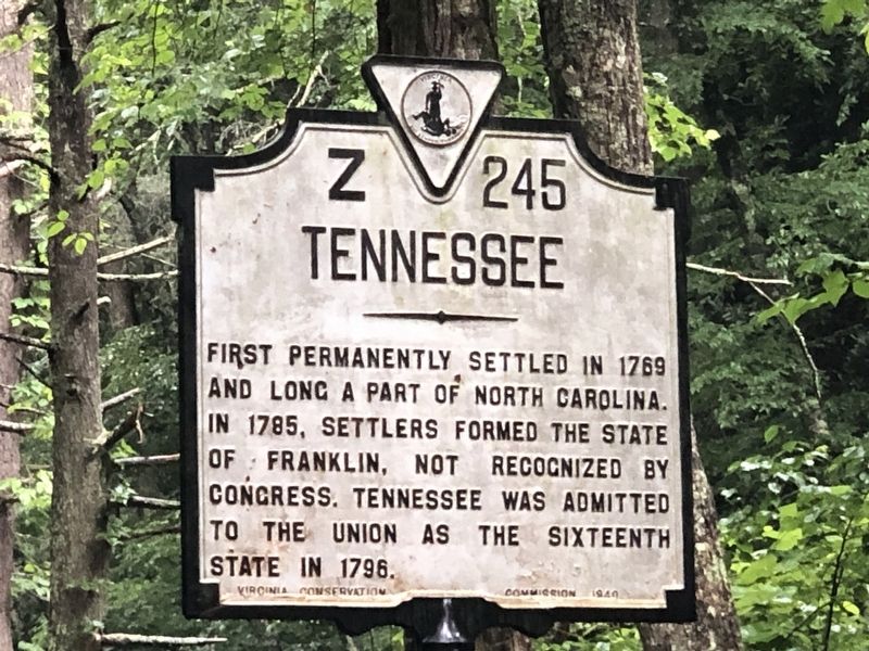
By Duane and Tracy Marsteller, June 24, 2023
Tennessee side of marker
RANKED BY RELEVANCE
1 ► Tennessee, Johnson County, Laurel Bloomery — Z-245 — Washington County, Virginia / Tennessee — Area 604 square miles / —  |
| On State Highway 91 1.6 miles south of Jeb Stuart Highway (U.S. 58), on the right when traveling south. | |||
| 2 ► Virginia, Washington County, Abingdon — Washington County, Virginia Revolutionary War Memorial — |
| Near Russell Road NW (Alternate U.S. 58) north of West Main Street (U.S. 11), on the left when traveling north. | |||
| 3 ► Virginia, Smyth County, Marion — Fight Like Devils! — Overmountain Victory National Historic Trail — |
| Near Seven Mile Ford Road (State Road 642) west of Spring Branch Road, on the right when traveling west. | |||
| 4 ► Kentucky, Boyle County, Danville — Isaac Shelby — 1750-1826 — |
| Near South 2nd Street. | |||
| 5 ► Virginia, Washington County, Abingdon — Women in Military Service for America — |
| Near Cummings Street (Alternate U.S. 58) at Mont Calm, on the left when traveling north. | |||
| 6 ► Pennsylvania, Washington County, Clarksville, East Bethlehem Township — The Abraham Tegarden Family — |
| On 10 Mile Street at County Park Road, on the right when traveling east on 10 Mile Street. | |||
| 7 ► Pennsylvania, Washington County, Donora, Carroll Township — Rabe Manor — |
| On 2nd Street Extension at Grant Avenue, on the right when traveling west on 2nd Street Extension. | |||
| 8 ► Virginia, Washington County, Abingdon — K-55 — Washington County Courthouse — |
| On East Main Street (U.S. 11) west of Court Street NE. | |||
| 9 ► Virginia, Washington County, Abingdon — Star-Spangled Banner — |
| Near Lieutenant Billy Webb Avenue 0.1 miles north of Cook Street. | |||
| 10 ► Virginia, Washington County, Abingdon — U.S.-Mexican War |
| Near Lt Billy Webb Avenue 0.1 miles north of Cook Street. Reported unreadable. | |||
| 11 ► Virginia, Washington County, Abingdon — Bronze "Yellow" Ribbon Monument — "Until You're Home Again" — |
| On Cummings Street at Grove Terrace Drive SW on Cummings Street. | |||
| 12 ► Virginia, Bristol — Bristol Trailhead — Mendota Trail — Mile 0.0 — |
| On Mendota Trail east of Island Road, on the right when traveling east. | |||
| 13 ► Virginia, Washington County, Abingdon — Animals in Service — "Always Faithful" — |
| Near Cummings Street (Alternate U.S. 58) at Mont Calm, on the left when traveling north. | |||
| 14 ► Virginia, Washington County, Abingdon — Cold War — 1947-1991 — |
| Near Lieutenant Billy Webb Avenue 0.2 miles north of Cook Street. | |||
| 15 ► Virginia, Washington County, Abingdon — For God and Country — |
| Near Cummings Street (Alternate U.S. 58) at Mont Calm, on the left when traveling north. | |||
| 16 ► Virginia, Washington County, Abingdon — K-59 — Governor John B. Floyd — |
| On West Main Street (U.S. 11) north of Partington Place, on the right when traveling north. | |||
| 17 ► Virginia, Washington County, Abingdon — History of Veterans Day — |
| Near Lieutenant Billy Webb Avenue 0.2 miles north of Cook Street. | |||
| 18 ► Virginia, Washington County, Abingdon — Medal of Honor — |
| Near Lieutenant Billy Webb Avenue 0.1 miles north of Cook Street. | |||
| 19 ► Virginia, Washington County, Abingdon — Poppies — |
| Near Lieutenant Billy Webb Avenue 0.2 miles north of Cook Street. | |||
| 20 ► Virginia, Washington County, Abingdon — POW★MIA — You Are Not Forgotten — |
| On Cumming Street SW at Grove Terrace Drive SW, on the right when traveling south on Cumming Street SW. | |||
| 21 ► Virginia, Washington County, Abingdon — Purple Heart — |
| Near Lieutenant Billy Webb Avenue 0.1 miles north of Cook Street. | |||
| 22 ► Virginia, Washington County, Abingdon — Spirit of 1776 — |
| Near Lieutenant Billy Webb Avenue 0.1 miles north of Cook Street. | |||
| 23 ► Virginia, Washington County, Abingdon — Split Rail Fence & The American Chestnut — (Castanea dentata) — |
| On Cummings Street SW at Grove Terrace Drive SW, on the right when traveling south on Cummings Street SW. | |||
| 24 ► Virginia, Washington County, Abingdon — The Minutemen — "Citizen Soldiers" — |
| On Cummings Street at Grove Terrace Drive SW, on the right when traveling south on Cummings Street. | |||
| 25 ► Virginia, Washington County, Abingdon — The War on Terrorism — |
| Near Lieutenant Billy Webb Avenue 0.2 miles north of Cook Street. | |||
| 26 ► Virginia, Washington County, Damascus — Transition from Rail to Trail — |
| On Virginia Creeper National Recreation Trail west of Mountain View Drive, on the left when traveling west. | |||
| 27 ► Pennsylvania, Washington County, Washington, North Franklin Township — Augusta Town — |
| On Franklin Farms Road 0.4 miles south of Franklin Farms Road and US 40, on the right when traveling south. | |||
| 28 ► Tennessee, Hamblen County, Morristown — 1B65 — Colonel Robert McFarland — 1759-1837 — |
| On Tennessee Route 160, on the right when traveling north. | |||
| 29 ► Virginia, Washington County, Damascus — Founders of Damascus — The Damascus History Tour — |
| Near South Beaver Dam Avenue just south of West Laurel Avenue (U.S. 58), on the left when traveling south. | |||
| 30 ► Ohio, Washington County, Belpre — 22-84 — Underground Railroad Crossings / Near Border War — |
| On Ridge Street at Locust Street, on the left when traveling west on Ridge Street. | |||
| 31 ► Virginia, Smyth County, Adwolfe — Mountain View Plantation: Antebellum Home Of The Abijah Thomas Family — |
| Near Thomas Bridge Road (County Route 657) at Octagon House Road, on the left when traveling south. | |||
| 32 ► Pennsylvania, Allegheny County, Jefferson Hills, Large — Yohogania Courthouse — |
| On 5th Street (Pennsylvania Route 837) 0.3 miles east of Glass House Road, on the right when traveling east. | |||
| 33 ► Virginia, Washington County, Abingdon — K-58 — Governor David Campbell — |
| On Cummings Street (Alternate U.S. 58) at Mont Calm Street, on the right when traveling north on Cummings Street. | |||
| 34 ► Virginia, Washington County, Abingdon — K-61 — John Campbell — |
| On Cummings Street (Alternate U.S. 58) at Mont Calm Street, on the right when traveling west on Cummings Street. | |||
| 35 ► Virginia, Washington County, Abingdon — The Virginia Creeper — |
| On Green Spring Road at Gibson Street SE, on the left when traveling south on Green Spring Road. | |||
| 36 ► Virginia, Washington County, Abingdon — World War I — |
| Near Lieutenant Billy Webb Avenue 0.2 miles north of Cook Street. | |||
| 37 ► Virginia, Washington County, Glade Spring — Mrs. Eliza M. Jones — |
| On Lee Highway (U.S. 11). | |||
| 38 ► Virginia, Washington County, Abingdon — Pvt. Michael Widener — Continental Army — Virginia Militia — Revolutionary War — |
| Near Lieutenant Billy Webb Avenue 0.1 miles north of Cook Street. | |||
| 39 ► Illinois, Morgan County, Jacksonville — Revolutionary War Patriots — |
| Near Myrtle Street. | |||
| 40 ► North Carolina, Tyrrell County, Creswell — Pettigrew Birthplace — ... and Last Resting Place — |
| Near Magnolia Road (County Route 1118) 0.3 miles south of Lake Shore Road, on the left when traveling south. | |||
| 41 ► Virginia, Russell County, Hansonville — Z-91 — Russell County / Washington County — |
| On Porterfield Highway (U.S. 19) 0.5 miles south of Clinch Mountain Road, on the right when traveling south. | |||
| 42 ► Virginia, Washington County, Abingdon — Black's Fort — Site of Washington County's First Court January 28, 1777 — |
| On Green Spring Road at Gibson Street SE, on the right when traveling north on Green Spring Road. | |||
| 43 ► Virginia, Washington County, Abingdon — Walnut Grove — Yeary Cabin — |
| On Plumb Alley east of Brewers Alley, on the left when traveling east. | |||
| 44 ► Kentucky, Washington County, Springfield — Nancy Hanks and Thomas Lincoln — |
| Near Beechland Road (Kentucky Route 438) at Lincoln Park Road ( Route 528), on the left when traveling east. | |||
| 45 ► Virginia, Alexandria, Old Town — 3 — Retrocession — City of Alexandria, Est. 1749 — Alexandria Heritage Trail — |
| On North Union Street at Queen Street, on the right when traveling north on North Union Street. | |||
| 46 ► Virginia, Smyth County, Seven Mile Ford — K-20 — William Campbell’s Grave — |
| On Lee Highway (U.S. 11) at Wadill Lane, on the right when traveling west on Lee Highway. | |||
| 47 ► Virginia, Washington County, Abingdon — Abingdon in the Civil War — Wyatt's Revenge — Stoneman's Raid — |
| On West Main Street (U.S. 11) at Cummings Street SW (Alternate U.S. 58), on the right when traveling east on West Main Street. | |||
| 48 ► Virginia, Washington County, Abingdon — Celebrate! A Social History of Abingdon — Designed and Painted by Ellen Elmes — Abingdon, Virginia, 2014 — |
| On West Main Street (U.S. 11) at Wall Street, on the left when traveling east on West Main Street. | |||
| 49 ► Virginia, Washington County, Damascus — Water Tanks — The Damascus History Tour — |
| On North Beaver Dam Avenue (U.S. 58) 0.2 miles north of West Laurel Avenue (U.S. 58), on the right when traveling north. | |||
| 50 ► Kentucky, Washington County, Springfield — Lincoln Homestead State Park — |
| On Beechland Road (Kentucky Route 438) at Lincoln Park Road ( Route 528), on the left when traveling east on Beechland Road. | |||
| 51 ► Tennessee, Union County, Maynardville — 1D 21 — Racoon Valley — |
| On Main Street (Tennessee Route 33) at Ailor Gap Road, on the right when traveling east on Main Street. | |||
| 52 ► Virginia, Orange County, Lake of the Woods — United States Colored Troops at the Battle of the Wilderness — May 6-7, 1865 — Civil War Study Group | Battle of the Wilderness... literally in OUR yards! — |
| On Lakeview Parkway near Shoosmith Road, on the left when traveling north. | |||
| 53 ► Virginia, Wythe County, Austinville — KD-5 — Fincastle County — |
| On Fort Chiswell Road (U.S. 520) just south of Austinville Road (County Route 619), on the left when traveling south. | |||
| 54 ► Maryland, Allegany County, Cumberland — Abandonment of Ft. Cumberland — Fort Cumberland Trail — |
| Near Prospect Square. | |||
| 55 ► Maryland, Frederick County, Knoxville — Frederick County / Washington County — |
| On U.S. 340, on the right when traveling north. | |||
| 56 ► Maryland, Washington County, Boonsboro — Washington Monument State Park — Home of First Completed Monument to Honor George Washington — |
| On Washington Monument Road 0.3 miles north of Zittlestown Road, on the right when traveling north. | |||
| 57 ► Pennsylvania, Allegheny County, Leetsdale — In Memory of Daniel Leet — Soldier and Patriot 1748-1830 — |
| On Broad Street. | |||
| 58 ► Tennessee, Carter County, Elizabethton — The Taylor Family — Sabine Hill State Historic Site — |
| Near West G Street (Tennessee Route 67) 0.1 miles west of Sabine Street, on the left when traveling west. | |||
| 59 ► Virginia, Bristol — K-123 — Walnut Grove Plantation — |
| On Lee Highway (U.S. 11/19) 0.1 miles west of Forsythe Road, on the right when traveling west. | |||
| 60 ► Virginia, Prince Edward County, Farmville — M-33 — Longwood Estate — |
| On Johnston Drive 0.1 miles south of Longwood Avenue, on the right when traveling south. | |||
| 61 ► Virginia, Washington County, Abingdon — K-53 — Barter Theatre — |
| On West Main Street (U.S. 11) at Partington Place, on the right when traveling north on West Main Street. | |||
| 62 ► Virginia, Washington County, Abingdon — Landon Boyd — Treason-Trial Juror |
| On A Street South East at Stone Street, on the left when traveling east on A Street South East. Reported permanently removed. | |||
| 63 ► Virginia, Washington County, Abingdon — The Muster Grounds — |
| On Muster Place at Colonial Road SW, on the right when traveling south on Muster Place. | |||
| 64 ► Alabama, Morgan County, Lacey's Spring — Lacey's Spring — |
| On U.S. 231 0.2 miles north of State Route 36, on the right when traveling north. | |||
| 65 ► Florida, Calhoun County, Altha — F-482 — Richards Cemetery |
| On Chipola Street (County Route 274) 1.3 miles west of North Main Street (Florida Route 71), on the right when traveling west. Reported missing. | |||
| 66 ► Kentucky, Washington County, Springfield — The Lincolns Move West — |
| Near Beechland Road (Kentucky Route 438) at Lincoln Park Road ( Route 528), on the left when traveling east. | |||
| 67 ► Maryland, Washington County, Williamsport — Confederate Hospitals in Williamsport — |
| On East Potomac Street (U.S. 11) west of North Artizan Street. | |||
| 68 ► Maryland, Washington County, Williamsport — Welcome to Williamsport — |
| Near Potomac Street (U.S. 11) at Commerce Street. | |||
| 69 ► Pennsylvania, Allegheny County, Coraopolis — Vance Fort |
| Near Fifth Avenue (Pennsylvania Route 51) 0.1 miles south of Mill Street, on the right when traveling south. Reported missing. | |||
| 70 ► Tennessee, Carter County, Johnson City — The Robertson Home, Site of First Court of Washington County — |
| Near Emmanuel Drive north of Cedar Grove Road, on the left when traveling north. | |||
| 71 ► Tennessee, Sullivan County, Blountville — Sullivan County — Tennessee's Second Oldest County — |
| On Bristol Highway (Tennessee Route 126) west of Anderson Road, on the right when traveling west. | |||
| 72 ► Texas, Burleson County, Caldwell — 7556 — City of Caldwell — |
| On West Buck Street at South Main Street (Loop State Highway 83), on the right when traveling west on West Buck Street. | |||
| 73 ► Texas, Washington County, Brenham — Community of Support & Respect for our Past — Flying Horses Carousel — |
| Near North Park Street at Davis Street. | |||
| 74 ► Virginia, Washington County, Abingdon — Lewis & Clark Expedition — |
| Near Lt Billy Webb Avenue 0.1 miles north of Cook Street. | |||
| 75 ► Maryland, Washington County, Hagerstown — Hagerstown Female Seminary — |
| On East Baltimore Street (U.S. Alt 40) at King Street, on the right when traveling west on East Baltimore Street. | |||
| 76 ► North Carolina, Chowan County, Edenton — Edenton Bell Battery — C.S.A. — |
| On South Broad Street, on the right when traveling south. | |||
| 77 ► North Carolina, Washington County, Plymouth — Why Plymouth? — Willing Citizens, Opportunity, Transportation — |
| On West Water Street at Monroe Street, on the right when traveling west on West Water Street. | |||
| 78 ► Pennsylvania, Greene County, Rices Landing — Railroad — |
| Near Main Street north of Rices Landing Road (County Route 1010), on the left when traveling north. | |||
| 79 ► Tennessee, Knox County, Knoxville — Sarah Hawkins — First Wife of Gov. John Sevier — 1746-1780 — |
| Near Main Street Southwest at South Gay Street, on the right when traveling east. | |||
| 80 ► Texas, Harris County, Houston, Washington Avenue Coalition / Memorial Park — 15726 — David Finney Stuart, M.D. — (August 15, 1833 - September 8, 1909) — |
| Near Washington Avenue. | |||
| 81 ► Virginia, Washington County, Abingdon — The Chase Begins — Abingdon Mustering Ground — |
| On Muster Place at Colonial Road SW on Muster Place. | |||
| 82 ► Maryland, Washington County, Hagerstown — United States Colored Troops — |
| On Charles Street at Sumans Avenue, on the left when traveling west on Charles Street. | |||
| 83 ► Maryland, Washington County, Williamsport — Shielding the Army — Where are the Confederates? — Gettysburg Campaign |
| On Greencastle Pike (Route 63), on the right when traveling north. Reported missing. | |||
| 84 ► Ohio, Perry County, New Reading — 14-64 — Randolph Mitchell House / Reading Township, Perry County — |
| On Rush Creek Road (Local Road 26) at Local Road 32, on the left when traveling east on Rush Creek Road. | |||
| 85 ► Ohio, Washington County, Marietta — The Fight for Freedom / Marietta College Activism — |
| On Putnam Street at Foster Lane, on the right when traveling east on Putnam Street. | |||
| 86 ► Oregon, Clackamas County, Oregon City — Joseph L. Meek — Born 1810 - Died 1875 — |
| On McLoughlin Boulevard (Pacific Highway) (State Highway 99) at 6th Street on McLoughlin Boulevard (Pacific Highway). | |||
| 87 ► Pennsylvania, Allegheny County, Rennerdale, Collier Township — The Panhandle Trail — Walkers Mill Station — Collier Township — |
| On Walkers Mill Road (County Route 3028) 0.1 miles south of Noblestown Road (County Route 3048), on the right when traveling south. | |||
| 88 ► South Carolina, Spartanburg County, Chesnee — Approaching Cowpens — Overmountain Victory National Historic Trail — |
| On North Carolina Avenue just north of West Cherokee Street (State Route 11), on the left when traveling north. | |||
| 89 ► Tennessee, Grundy County, Tracy City — Frank White House — Town of Tracy City — |
| On 10th Street south of 3rd St, on the left when traveling south. | |||
| 90 ► Texas, Austin County, San Felipe — Founding the Town — Lot 47 — |
| Near 2nd Street at Farm to Market Road 1458. | |||
| 91 ► Texas, Nacogdoches County, Nacogdoches — 9246 — Stephen Fuller Austin — (November 3, 1793 - December 27, 1836) — |
| Near North Street (Business U.S. 59) north of Griffith Boulevard, on the right when traveling north. | |||
| 92 ► Virginia, Russell County, Dickensonville — X-4 — Old Russell County Courthouse — |
| On Trail of the Lonesome Pine (Alternate U.S. 58) east of Upper Copper Creek Road (County Route 671), on the left when traveling east. | |||
| 93 ► Virginia, Smyth County, Saltville — Saltville Defenses — Saltville and Salt Manufacturing — |
| On West Main Street (Virginia Route 91) at King Avenue, on the right when traveling west on West Main Street. | |||
| 94 ► Virginia, Washington County, Abingdon — Veterans Memorial Park — |
| On Lt Billy Webb Avenue 0.1 miles north of Cook Street, on the right when traveling north. | |||
| 95 ► Virginia, Washington County, Abingdon — Washington County Iraq Memorial — |
| Near Lt Billy Webb Avenue 0.1 miles north of Cook Street. | |||
| 96 ► Kentucky, Jefferson County, Louisville — You Stand on Historic Ground — |
| Near Old Stage Coach Road 0.1 miles east of Long Run Road, on the right when traveling east. | |||
| 97 ► Kentucky, Washington County, Springfield — Captain Abraham Lincoln, Sr. — |
| On Beechland Road (Kentucky Route 438) 0.2 miles north of Lincoln Park Road ( Route 528), on the right when traveling north. | |||
| 98 ► Maryland, Montgomery County, Seneca — Seneca Mill — |
| On Old River Road. | |||
| 99 ► Maryland, Washington County, Hagerstown — Washington Confederate Cemetery — |
| On outh Potomac Street (Maryland Route 65), on the right when traveling north. | |||
| 100 ► Missouri, Washington County, Potosi — Durham Hall - 1798 — "The Cradle of Texas" |
| On South Missouri Street just south of West High Street (State Route 8), on the right when traveling south. Reported missing. | |||
110 entries matched your criteria. The first 100 are listed above. The final 10 ⊳
Thin black lines indicate changes in relevance. Between each pair of lines entries are ordered geographically but all have the same relevance.
* Inflectional forms of words are their plurals, singulars, and possessives as well as gramatical tenses and similar variations.
Nov. 13, 2026