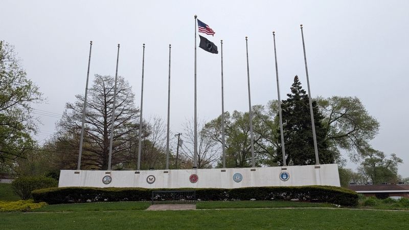
The National Council for the Encouragement of Patriotism, Inc. in 1970 urged the governors of Michigan, Wisconsin, Illinois, Indiana, Kentucky, Tennessee, Georgia and Florida to officially dedicate U.S. Route 41 as the "Highway of Flags" a tribute . . . — — Map (db m302173) HM WM
A rare conifer thought to be long extinct, was rediscovered in 1945, at Szechuan, China.
Foliage, fern like in spring, turns a pale pink before dropping in the fall.
The tree grows here in honor of the 1300 missing in action of the Vietnam . . . — — Map (db m302177) HM WM
In 1966, Mrs. Mary Lou Kieswetter of Munster, Indiana, mother of a young serviceman, became concerned by the lack of respect for the American flag. She launched a personal crusade that has ignited a flame of patriotism throughout our country. . . . — — Map (db m302175) HM
Here, the Potawatomi Indian Trail, a southern branch of the old, historic Ft. Wayne - Ft. Dearborn Trail, proceeded in a southwesterly direction through old Lake Station (East Gary), Liverpool, and on past the Indian ceremonial grounds at Wiggins . . . — — Map (db m254701) HM
This bank or sidehill barn built in 1916 using the latest and best bracing and roof design was the farm's most important structure. It served many functions, including the increasingly profitable dairy operation. The upper floor was mainly hay . . . — — Map (db m286283) HM
Irish immigrants Dennis and Catherine Buckley fled the Potato Famine in the mid-1800's and purchased the original 79 acre homestead for 50¢ per acre from soldiers who had received land grants after the war. Thrilled to own his own land, Dennis . . . — — Map (db m286188) HM
Grain brought to the 1916 double-crib granary was stored in bins overhead and ear corn in the cribs along either side. Slatted walls in the cribs allowed air circulation to dry and preserve the farmer's most important crop. The central driveway, . . . — — Map (db m286669) HM
The oldest brick house in Lake County,
home of Melvin Halsted, founder of
Lowell, was built in 1849. His pit and
kilns were located just across Cedar
Creek.
Acquired for the community through the
combined efforts of interested . . . — — Map (db m231125) HM
The main house's original kitchen built in the 1850's adjacent to the NE corner of the house was moved north of the present kitchen in 1917 for use as separate living quarters and later to this present location for use as an office. This replica of . . . — — Map (db m286284) HM
This is the site of the Main Street School grades 1 thru 12, built in 1896 with bricks from the Lowell brick yard. The high school students moved to a new high school in 1916. This school closed in 1973. — — Map (db m231122) HM
Milkhouse
The milkhouse was built about 1916 to cool milk from the Buckley's purebred Holstein cows. Milkcans were set in a tank with cool water pumped in by a windmill. Milk was shipped by train daily to sell in Chicago. Some of the milk . . . — — Map (db m286286) HM
The original Buckley Schoolhouse built on this site, used for classes 1850's-1922, was moved southwest 3 miles to use for farm storage and later torn down. This replica uses bricks from the original foundation along the front. Southern Lake County . . . — — Map (db m286228) HM
Dedicated 1905
In honor of those who served in the Civil,
Mexican, and Spanish-American Wars
and the War of 1812 by the Women of Tri-Creek. — — Map (db m307767) WM
The west part of the near 1920 garage extended the domestic work area for washing and boiling clothes, summer cooking, milk separating, and possibly food preserving and soap-making. Thus it kept the main house cooler and cleaner in the summer. This . . . — — Map (db m286268) HM
After settling and living in a log house for the first few years, the Buckleys built the original or front part of the present house in the early 1850's. It is a typical I-house (found in Indiana, Illinois, and Iowa) and characterized by . . . — — Map (db m286269) HM
Originally built about 1850 probably by William Holmes six miles east of here, the log house was discovered under siding and plaster during demolition. The logs were reused to build this house, a sample of mid-1800's southern Lake County. No indoor . . . — — Map (db m286231) HM
Henry D. Palmer, M.D. (1809-1877) located at this site in 1836. First physician in Lake County, he was also counselor to the pioneers for 40 years and member of the underground railroad aiding escaped slaves. — — Map (db m27716) HM
Part of a transcontinental trail used by prehistoric peoples of North America, it passed through modern Detroit, Rock Island and Davenport in the Midwest. The trail was important into the 19th century. — — Map (db m254794) HM
From Danvers, Massachusetts
Entered claim and built log cabin 1835.
Brought family in 1836.
Erected first grist mill in Lake County 1838
Set aside this Commons and planted elms.
Advocated and practiced honesty, morality,
temperance, . . . — — Map (db m270776) HM
In 1680 the Pottawatonie Indians came from Wisconsin and lived in this area. In 1830 an Indian village was found just south of 330 and east of Broadway. McGwinn's Village contained a large dancing floor with 16 trails converging, also a burial . . . — — Map (db m254789) HM
37 fiberglass tulip structures, which were organized and made possible by the Munster Civic Foundation, are located around town. Indiana University Northwest student, Tyler Kaufman, designed the tulip structures. The tulips represented the first . . . — — Map (db m301768) HM
The Bieker's home and barn sat on 44 acres of land. In 1969, Helen Kaske Bieker, pictured to the right, sold 32 acres of the land on the westside of Columbia Avenue to the Munster Parks Department and the Munster School Board for $50,000.
The . . . — — Map (db m299111) HM
Brass Tavern
In 1837, David Gibson built a log stagecoach inn near the corner of today's Ridge Road and Columbia Avenue.
Julia Watkins Brass, pictured to the left, and husband Allan Brass took over the property in 1845. The building, . . . — — Map (db m298820) HM
Munster's Beginnings Until 1763, the Munster area was under French rule. The area was then under British rule until after the Revolutionary War.
In 1816, Indiana became the 19th state, but the Munster area was an undeveloped swamp.
In . . . — — Map (db m299094) HM
Oak Woodland Restoration
Heritage Park is located on the narrow sand ridge, once the Lake Michigan shoreline, and is home to native Black and White Oaks. Without management for 75 years, the woodland had become crowded with non-native or . . . — — Map (db m298701) HM
Monarch migration path
Did you know?
Munster Indiana is on the direct path that Monarchs fly north from Mexico in the spring and south from Canada in the fall.
We help by providing Milkweed as their host plants for the caterpillars, and . . . — — Map (db m301770) HM
Schools
The area's first school opened in 1852 by the North Township Trustee. It was a one-room schoolhouse on the corner of Ridge Road and present-day Greenwood Avenue. The small 14 by 16 foot building cost $16. Chauncey Wilson was the first . . . — — Map (db m299976) HM
Site of Brass Tavern
Only one on Chicago Trail through Lake County.
Tablet placed on horse block from Brass Homestead by the Julia Watkins Brass Chapter of the Daughters of the American Revolution Crown Point, Indiana 1926 . . . — — Map (db m298512) HM
Stallbohm Barn-Kaske House
Circa 1890 Circa 1910
have been placed on the
National Register
of Historic Places
by the United States
Department of the Interior
April 1, 1998 — — Map (db m302171) HM
The earliest known windmills were developed in Persia more than a thousand years ago. However, the early windmills were not nearly as efficient as they are today. Even as late as the 1400's, large European windmills had to be turned by hand to . . . — — Map (db m298481) HM
Aartje Jabaay
Accompanying her husband Peter, they were the first Dutch immigrants to acquire land along Old Pike (Ridge Road).
Martha Dyer Hart
Martha and her husband Aaron owned most of south Munster, substantial tracts in Crown . . . — — Map (db m301719) HM
The "Ideal Section," a portion of the Lincoln Highway (US 30), was a prototype of construction technology intended to make it the finest road in the world.
The section begins one half mile west of US 41 and extends 1.3 miles westward to Bank . . . — — Map (db m213121) HM
Built, 1853, approximately one half mile south; closed, 1907; moved to this site and restored for educational and community uses, 1993-1994. One of twelve St. John Township schools; structure typical of early one-room school buildings in Indiana. — — Map (db m64172) HM
This plaque is dedicated to the history of America's first transcontinental highway, which passed 137 feet south of this spot. A section of Macadam is displayed in the sidewalk. The highway in the Schererville area followed the Sauk . . . — — Map (db m204887) HM
Early History
Schererville can trace its history to the days of Native Americans and their trails across Northern Indiana.
• Much of the region was marsh and wetlands north of the Kankakee River and south of Lake Michigan.
• The best . . . — — Map (db m302179) HM
The Lincoln Highway. United States' first transcontinental highway, constructed 1913-1928, from New York City to San Francisco. Dedicated to the memory of Abraham Lincoln. Conceived by Carl G. Fisher to encourage building "good roads." . . . — — Map (db m213118) HM
Cyclists Initiate Road Advocacy - The idea that America needed better roads did not originate with the invention of the automobile, rather with bicyclists known as "wheelmen." Challenged by both rutted roads of gravel and the antagonism of . . . — — Map (db m301870) HM
As the saying goes,"You cannot have a great building on a weak foundation." The same thought applies to building a business, and for the Schrage Family and Centier Bank, the same applies to building a culture as well. While Henry and Walter Sr. . . . — — Map (db m256564) HM
Henry Schrage (1844-1932) was born into one of the first families of Whiting. An entrepreneurial spirit, he learned a strong work ethic from his humble beginnings as a German immigrant. Upon returning home after serving in the Union Army in the . . . — — Map (db m256487) HM
On this site the former Immaculate Conception Church and School stood from 1924 until it was razed in 2018. Rev. Michael Kosko celebrated the first Mass at Midnight, on Christmas Eve, 1924. The last Mass was celebrated on Sunday, March 2, 2014, at . . . — — Map (db m256574) HM
The original Schrage family mansion is located at 2006 Schrage Avenue. Henry Schrage lived in this home with his wife, Carolina, and their six children. Henry was a naturalist, whose hobbies included beekeeping and birdwatching. He jokingly . . . — — Map (db m256485) HM
In Thanksgiving to God and in lasting memory ot the men and women who served their country in all wars
Renovation Contributors:
City of Whiting, Whiting City Council, School City of Whiting, American Legion Post 80, American Legion Auxiliary . . . — — Map (db m256399) WM
During the course of America's involvement in Vietnam, over 58,000 U.S. service men and women lost their lives. Although it was never officially classified as a "war," Vietnam was America's longest period of continuous combat, 1959 - 1975, prior to . . . — — Map (db m256396) WM
For over eight decades, White Castle fed the souls of craver generations on this very site. Creating countless memorable moments, and feeding the souls of craver generations along the way. In fact, we estimate that we served over 105 million . . . — — Map (db m256393) HM
Detachment A-Team
101 Company C
5th Special Forces
came under
attack by a North Vietnamese tank unit on
February 6, 1968 in the Battle of Lang Vei.
LaPorte native, Green Beret Master Sergeant.
Charles W. Lindewald
was . . . — — Map (db m77158) WM
Proposed in 1905 as a 742 mile, straight-line, high speed route, without crossings; estimated ten hours travel time at a cost of ten dollars. Just under twenty miles, between La Porte and Chesterton, were constructed, 1906-1911. — — Map (db m43376) HM
Two Civil War training camps: Colfax and Jackson, were located near La Porte. The 9th and 29th Indiana Volunteer Infantry regiments were organized and trained here. — — Map (db m43375) HM
(Left Tablet)
The LaPorte Historical Society
Here places the names of the men who built the stockade:
A.P. Andrews, Jr. - Commander -
Peter White - Captain -
William Adams • Elijah Brown • Daniel Carpenter • Jacob Coleman • . . . — — Map (db m77076) HM
1832 - First log school
1883 - Two story brick school for grades 1 - 8
1900 - Grades 9 - 11 added
1912 - Grades 9 - 11 discontinued
1948 - New one story school with 4 classrooms and gym
1955 - Four classrooms added
1963 . . . — — Map (db m77098) HM
LaPorte Centennial
1832 – 1932
On this site was built
the first log cabin in LaPorte
Here was held the first session
of the County Commissioners
Erected in memory of the pioneers
by Miriam Benedict Chapter
Daughters of . . . — — Map (db m77178) HM
The Ordinance Line located here was intended to form northern borders of Ohio, Indiana and Illinois, but these resp. borders were shifted northward at statehood. Called “Indian Boundary Line” in Indiana, it formed here borders between . . . — — Map (db m77262) HM
Side One
Northwest Territory formed 1787; Indiana Territory formed 1800. Admission of Ohio 1803 and formation of Michigan Territory 1805 established Indiana Territory's northern boundary at southern tip of Lake Michigan. When Indiana became . . . — — Map (db m43369) HM
(Front Side)
Afghanistan
Iraq Kuwait
A nation that forgets its defenders
is a nation itself that
will be forgotten
(Rear Side)
Fallen Heroes
Sgt. David M. Heath
Cpl. Sascha Struble
Sgt. Kraig D. . . . — — Map (db m78201) WM
La Porte University. La Porte University was established in the early 1840s to include law, literary, and medical departments. The medical department, later Indiana Medical College, began classes by 1842. Its distinguished faculty attracted . . . — — Map (db m202849) HM
(Panel 1)
Dedicated to Viet Nam Veterans
We gave our full measure of devotion
Veterans helping veterans
(Panel 2)
Together We Can
Viet Nam Veterans
Chapter Three
LaPorte Co. Indiana
"Honor to those . . . — — Map (db m78202) WM
In Honor Of
Wilbur A. Higlendorf
Arthur C. Woodcox
Robert J. Hartman
Clarence G. Niendorf
Who in the time of our country’s need, willingly laid aside their duties, to enter the military service, offering their lives, fortunes and sacred . . . — — Map (db m77332) WM
Side One
County formed by Indiana General Assembly and La Porte selected county seat 1832. Three courthouses built on this site: first 1833, second 1847-1848. Present courthouse constructed 1892-1894 of Lake Superior Red Sandstone; designed . . . — — Map (db m43373) HM
Side One
La Porte's first public library was established 1896. La Porte City School Board was awarded $27, 500 Carnegie grant 1916; by 1919 local support had been secured to meet grant requirements. Architect Wilson B. Parker designed the . . . — — Map (db m43371) HM
1 Potawatomi Indian Women
2 First Log Cabin
3 Paul Bowman, early mail carrier
4 Aerial view of Pine Lake and Holmes Island
5 Girl riding Crown Bicycle
6 The Door Prairie Barn, 1876
7 Cart from Belle Gunness farm
8 1921 girl reading . . . — — Map (db m242135) HM
Meinrad Rumely
Meinrad Rumely was the founder and guiding spirit of the Rumely Companies for more than 50 years. He came to America from Germany in 1848, and in 1853 on this site opened a blacksmith shop that was to grow into a large . . . — — Map (db m43463) HM
A tribute to
Harry August Backus • John William Burns • Chester L. Coplin • Hamon Gray • John E. Hawn • William L. Hubner • John E. Hunt • Chester Stewart Kiff • George Luebker • John C. Naill • Louis Edward New • Roy E. Newell • Norman Lay . . . — — Map (db m77331) WM
(Front Side)
Operation
Desert Storm
1991
Duty, Honor, Country
(Rear Side)
In Honor
Of the LaPorte County
Servicemen and Women
Who, Through
"Operation Desert Storm",
Participated in
The Liberation of Kuwait . . . — — Map (db m78203) WM
The Pinhook Bog area features two very different habitats. The Upland Trail highlights a rich Beech and Maple forest growing on top of a glacial moraine formed about 15,000 years ago. The Bog Trail leads to a depression in the moraine created when a . . . — — Map (db m75623)
Near here settled pioneer Quakers, including the Aaron Stanton Family. In 1836 William Bond agreed to convey the Society of Friends three acres of land for a meeting house lot and burial ground. Bond died in 1837 and in 1841 the La Porte Circuit . . . — — Map (db m77105) HM
This marks the site of Meinard Rumely’s Blacksmith Shop where in 1853 he built his first threshing machine.
In the factory later erected here were produced pioneering steam engines and steam plowing engines, and in 1908 parts for the first . . . — — Map (db m43432) HM
How It All Began
The time was 1912. One million plus motor vehicles were in use in America, primarily in urban settings. To that time only eight recorded motor car travelers had ventured a trip across America. Paved roads were . . . — — Map (db m77213) HM
French fur traders came to Northwest Indiana in the 1600's. A natural opening through the forest served as a gateway to the prairies beyond. They called this opening, La Porte, meaning, “the door”, from which the county received its . . . — — Map (db m77215) HM
Meinrad Rumely (1823-1904), a German immigrant, founded a blacksmith shop here 1853, which grew into a dominant company through reorganizations and acquisitions. Rumely companies in La Porte benefited from available rail transportation plus . . . — — Map (db m43362) HM
Given to the people of Michigan City as a cultural and civic center by Mrs. Catherine Barker Hickox in 1968. The original house was built on this site (circa) 1858 by John Barker Sr. (1814-1878). It was reconstructed in 1901 by John H. Barker . . . — — Map (db m77403) HM
The mansion before you was built by freight car magnate John Barker, Sr. in 1857.
Barker lived in this home with his wife, Katherine, and daughter, Catherine. Tragically, both parents died in 1910, making Catherine the world's richest . . . — — Map (db m273351) HM
In the aftermath of George Rogers Clark’s conquest, skirmishers from Cahokia led by Capt. B. Hamelin and Lt. T. Brady, who had raided Fort St. Joseph, were defeated and captured near here by fur-trader Etienne Champion and Potawatomi allies of the . . . — — Map (db m72908) HM
One of three Civil War training camps in La Porte County. Site is one fourth mile west. Named for Colonel Edward Anderson. Used 1863-1864 to train Indiana Union volunteers of the 127th, 128th, and 129th regiments. — — Map (db m969) HM
Westcott Park, a gateway to Michigan City, is dedicated in memory of Charles R. Westcott, whose lifetime of extraordinary service, especially to children, significantly enriched our community.
For nearly 50 years, Westcott . . . — — Map (db m202852) HM
The U.S. Fish & Wildlife Service and Great Lakes Fishery Commission work in partnership with the Indiana Department of Natural Resources to control sea lampreys in the Great Lakes. Tributaries harboring larval sea lampreys are periodically treated . . . — — Map (db m299132) HM
The role of education is well-evidenced in two of the largest buildings in the district. The Public Library and the Central School were constructed on opposite sides of East 8th Street. While other schools were constructed in Michigan City, . . . — — Map (db m202871) HM
One of the town's founding families, the Barker's, have patronized Trinity Episcopal Church throughout its history. Among the earliest recorded services at the church was the 1841 wedding of Cordelia Collamer to John Barker, Sr. He and his son, . . . — — Map (db m310322) HM
As retail crept south from the original center of town near 4th and Franklin, several churches became a part of the commercial district which had been constructed long before retail businesses moved south. Three churches in the district, St. John's . . . — — Map (db m310319) HM
The first commercial business in Michigan City was established by Samuel Miller in 1833. Miller started a store supporting grain trade by farmers who brought products to the port. Several more warehouses were built as vessels on Lake Michigan began . . . — — Map (db m310336) HM
In 1845 Lodner Darvontis Phillips invented and launched the first submarine on the Great Lakes in Trail Creek at the foot of the Old Lighthouse. Phillips designed his submarines for salvage and warfare. His cigar-shaped design was the forerunner of . . . — — Map (db m244320) HM
The original plat of Michigan City was enlarged during the 1850s on the east and west sides. The Haskell & barker Historic District comprises approximately twenty-five blocks lining Washington and Wabash Streets on the near west side of downtown . . . — — Map (db m244464) HM
Hoosier Slide was located directly across the harbor. Standing over 200 feet high, it was for centuries a landmark for the Indians traveling the lake and later for French explorers. In modern times it was a great tourist attraction. With the . . . — — Map (db m244319) HM
Presented by
The Daughters of Union Veterans
of
the Civil War - 1861-1865
In memory of
our Fathers and
The Grand Army of the Republic
June 12, 1939 — — Map (db m72910) WM
This lighthouse built in 1858 replaced 1837 lighthouse built at water's edge. Remodeled in 1904. Light placed at end of pier. Seven keepers and fourteen assistant keepers served here 1837-1940. — — Map (db m75722) HM
1941 — 1945
Dedicated To
The Memory
Of These
Our Boys
And All Who Served in
World War II
Gilford Albertson S.M. 3/C • Sgt. James Allie • Lt. Walter Baranowski • Cpl. Stanley Batuzik • Pvt. Bernard Baxter • Ens. John T. . . . — — Map (db m77402) WM
347 entries matched your criteria. Entries 101 through 200 are listed above. ⊲ Previous 100 — Next 100 ⊳