Pioneer Kennebec Loyalist Scott Family
Settled by Salmon River Arden 1855
Daniel Scott [1822-1911] & Phoebe Parks [1815=c1891]
Children: Eunice, David, William, Dolly, Daniel
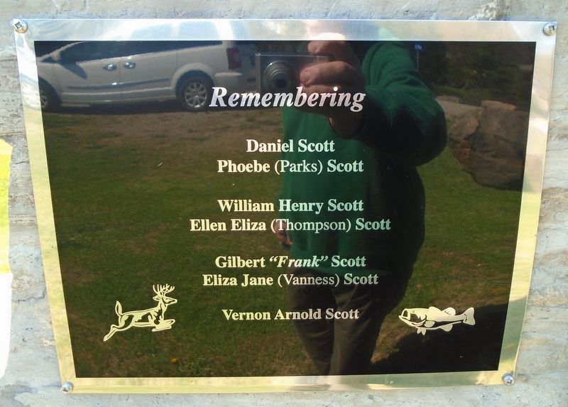
Remembering
Daniel Scott · Phoebe (Parks) Scott . . . — — Map (db m273621) HM
[Former Township Logo reads]
Township of Kennebec
Flying above the Rest
Incorporated 1862
—————————
This boulder comes from Buck Lake
site of the first settlement in an area
that has been known for over 180 years
by the Algonquin . . . — — Map (db m273618) HM
Surveyed in 1852-53 by Thomas Fraser Gibbs, Provincial Land Surveyor, this route was opened as part of a network of "colonization roads" planned by the government to encourage settlement in the southern region of the Precambrian Shield. Under the . . . — — Map (db m273701) HM
The World's War 1914 - 1918
While on Active Service
Died
No. 835541 · Pte H.R. Abbott · Mt. Grove 1916
Gassed
No. 835443 · Corp. A. Lewis · Avion June 4, 1917
Killed
No. 2129416 · Pte H.R. Cronk · Roy Road . . . — — Map (db m273678) WM
More than a pretty flower
The blue flag is a native herb, found in marshes, swamps, moist fields, and meadows from southern Saskatchewan to the Maritimes. In 1999, this large member of the iris family was adopted as the . . . — — Map (db m273734) HM
Benton's Cut was named by local railroaders in memory of K&P foreman Chancy Benton. When Colonel George Flower of New York took over the building of the railway, he was faced with the need of experienced men to supervise the work. He brought . . . — — Map (db m273963) HM
The caboose carried the conductor and
brakeman at the end of a freight train, so
they could monitor the air brakes, watch
for derailments, and throw track switches
when necessary. This caboose was built
in Montreal by CN Rail in 1976, and . . . — — Map (db m273807) HM
This livestock pen is a reproduction of the enclosure that stood on this site in the early twentieth century, to hold livestock brought to trackside by farmers for shipping to an abattoir. The reproduction was constructed of local hemlock and . . . — — Map (db m273809) HM
The building on the right in the photo with the wooden steps and porch is Sharbot Lake's first railway station. It was located here. The station was built by the Kingston and Pembroke Railway shortly after its track was laid through in 1876. . . . — — Map (db m273952) HM
This bell was once in the Presbyterian Church which was built in 1880 on the site of the current Masonic Lodge on Road 38 in Sharbot Lake. In 1923, the church was sold to the Masonic Lodge along with the bell. However, when the building burned . . . — — Map (db m273862) HM
These signs indicate the distance to the next station. They were originally placed on telegraph poles, and later on their own posts.
CPR drawing, 1915 [reads]
MILE PLATE
For detail, see punched out bridge No Plate above. . . . — — Map (db m273771) HM
This "speeder" manufactured by
Railcar Canada of South Lancaster ON
moved work or inspection crews
along the track. In the late 20th century
speeders were replaced by pickup
trucks with auxiliary "hi-rail" wheels.
[Illustration] . . . — — Map (db m273791) HM
Before the days of radio communication, train movement was controlled by a timetable and train order system. Orders were issued by a centralized dispatcher and sent to outlying station operators or agents via telegraph or telephone. The order . . . — — Map (db m273913) HM
During the steam era of the railway, the Pump House and its machinery played a pivotal role in ensuring the essential resource of water was available to the steam locomotives. Steam locomotives consumed large amounts of coal and water to produce . . . — — Map (db m286035) HM
This small motorized cart was probably manufactured by Fairmont Railway Motors of Minnesota. It was used by section crews to transport 1-2 workers along the track with their tools and spikes. More supplies could be carried on the trailer. The . . . — — Map (db m273762) HM
The items laid out on the trailer or "lorry" pulled behind the motor car, are typical tools used by a section gang. This crew was responsible for repairing and maintaining a section of track, and their tools had remained basically the same since . . . — — Map (db m273787) HM
This tree planted in memory of
Shirley Peruniak, 1926 - 2020
By the Central Frontenac Railway Heritage Society
and the Granite Ridge School Council
Shirley was the driving force in gathering local history,
stories and . . . — — Map (db m273910) HM
This box was used for holding a variety of materials at the Canadian National Railways Pointe St. Charles Shops in Montreal, where our Railway Heritage Park caboose was built in September 1976. The box was moved with a fork lift.
Photo by Ron . . . — — Map (db m273848) HM
In 1987, Sharbot Lake Beach was the site of 12 year old Simon Whitfield's first Kids of Steel Triathlon. In 2000, Simon became the inaugural gold medal winner in triathlon at the Sydney Australia Olympics.
Olympic Distance: 1500m swim, 40k . . . — — Map (db m273956) HM
The Angry Farmer
In the early days of the K&P, a local farmer, Bill Francis, who lived near the rail line, discovered that two of his cattle were killed after wandering onto the tracks. Feeling that the crew involved weren't showing the . . . — — Map (db m273841) HM
Before large trucks, reliable, refrigeration and the ability to freeze meat for transport existed, livestock was shipped by rail, in cattle cars. To facilitate this, stock pens for receiving and shipping the livestock were built in small . . . — — Map (db m273811) HM
On May 8, 1876, the Kingston and Pembroke Railway crossed The Narrows of Sharbot Lake on this rock-filled causeway. In 1882, as the construction of the Ontario and Quebec Railway (later the Canadian Pacific Railway) pushed through Sharbot Lake, . . . — — Map (db m273971) HM
From here, the Kingston and Pembroke Railway headed
north. Incorporated in 1871, the Kingston and Pembroke
Railway Company was chartered to run between the two
towns with the purpose of gaining access to the forests and
minerals found in the . . . — — Map (db m273759) HM
This bar with a point on one end can be used for aligning rails, "nipping" a tie to start a spike, or for prying. It can also serve as a jack handle, but the round end should not be used in a bolt hole to roll a rail!
[Uncaptioned photo of . . . — — Map (db m273789) HM
Because the trackbed of the Kingston & Pembroke Railway was built during the "hard times" of the depression in the 1870s, as little money as possible was spent on it. Grades were steep and curves were plentiful. With stops every 5 miles or so, . . . — — Map (db m273840) HM
Kingston and Pembroke Railway
Affectionately known as the Kick and Push, it was incorporated in 1871 to run from Kingston to Pembroke. The K&P crossed Sharbot Lake on a rock-filled causeway, May 8, 1876. The line was opened to . . . — — Map (db m273856) HM
[Kingston and Pembroke Iron Mining Company stock certificate excerpt]
With the arrival of the railway in 1876 came new prosperity. Sawmills & mines now had easy access to markets. Sharbot Lake soon had several stores, hotels & 3 doctors. . . . — — Map (db m273921) HM
In 1888, the Kingston & Pembroke Railway built the Union Hotel on this site at the junction of the K&P and the CPR lines. The hotel catered to labourers, tourists and fishermen. When Herb and Millie Moyst purchased the hotel in 1946, it became . . . — — Map (db m273918) HM
The station was built circa 1884 by the Canadian Pacific Railway. The William C. Van Horne inspired
design was a simple two-storey building with the Agent's quarters on the second floor and a waiting
room, ticket office (the protruding windows) . . . — — Map (db m273738) HM
Known locally as the "fisherman's hotel", the Union Hotel
was built circa 1889 and named to reflect the junction of the
K&P, Ontario and Quebec Railways. Built by the Kingston
and Pembroke Railway, it was later called the Sharbot
Lake Hotel, . . . — — Map (db m273912) HM
This is the former site of a 40,000 gallon water tower which was removed in 1964. The original wooden one (inset) was replaced with a more modern steel version. Lake water was pumped to the tower and flowed through underground piping to . . . — — Map (db m273817) HM
Signalmen used these small carts to hold their tools and supplies. The carts were pushed along the track but could be lifted off when a train was approaching. This one was built by Transport Products
Corp. in Louisville, Kentucky. — — Map (db m273767) HM
This gasoline-powered tug manufactured by the Whiting Corp. is used for moving railway cars on the track. It has road wheels as well as steel wheels (missing on this example) so it can move from track to track, and be stored off the track. Its . . . — — Map (db m273824) HM
This motor was used to turn locomotives around, and is similar to a motor seen here on the K&P turntable in Kingston.
It was mounted vertically on the side of the turntable (see the detail photo) and was powered by compressed air produced by . . . — — Map (db m273838) HM
Dedicated in honour of
all Veterans who served in
the Armed Forces of Canada
1914 - 1918
1939 - 1945
The Korean War
[Dedicated] November 11, 1987 — — Map (db m273919) WM
Sharbot Lake was the intersection of the original Canadian Pacific Toronto to Montreal mainline and the Kingston & Pembroke Railway. You are now just east of where the lines separated after sharing a right of way from south of the village. See . . . — — Map (db m273808) HM
This sign indicates an area where trains are allowed to move at restricted speed with verbal permission from a yardmaster, rather than under signal light control. A yellow lamp can be placed
behind the round hole.
CPR [Yard Limit sign . . . — — Map (db m273804) HM
English:
Designed by the Montréal architectural firm of Hopkins, Lawford and Nelson, the Kingston Custom House was built in 1856-59 for the government of the united Canadas. The symmetrical composition of the two-storey ashlar . . . — — Map (db m140194) HM
[English] A commanding figure in Canadian Methodism during the late 19th and early 20th centuries, Carman was born in Iroquois and educated at Victoria College, Cobourg. He worked briefly as a teacher and was then . . . — — Map (db m255699) HM
By 1790 the mill, tavern and stores established here near the Bay of Quinté had stimulated the growth of a settlement. Named “Belleville” in 1816, the village progressed steadily as a milling and shipping centre, and in 1834, the thriving community . . . — — Map (db m255695) HM
[English] This imposing structure was erected in 1872-73 to house the public market and administrative offices of the rapidly expanding municipality of Belleville. It was designed by John Evans, a local architect, . . . — — Map (db m260657) HM
Belleville Collegiate Institute and Vocational School, the city's only public high school for over a quarter of a century, stood on this site on land set aside for educational purposes in the municipality's original town plan in 1816. The . . . — — Map (db m262551) HM
[English] Meyers gained fame as a loyalist spy during the American Revolution. He recruited soldiers, gathered intelligence, and carried dispatches through enemy lines for the British army in his native New York. . . . — — Map (db m255607) HM
It is essential to protect the commemorative architectural features of Glenmore National Historic Site for all Canadians, now and in the future. After more than a century of exposure to the elements, the built-in gutter system and slates were badly . . . — — Map (db m255917) HM
In 1867 contractor John Forin built this stone building with brick façade to house a fire station, police office and cells. Belleville Town Council met here until 1873. In 1916 a permanent firefighting force replaced volunteers. Firemen were on . . . — — Map (db m262268) HM
[English] The largest Protestant denomination in Canada during the late 19th and early 20th centuries, the Methodist Church (Canada, Newfoundland, Bermuda) was established in 1884. Its formation marked the . . . — — Map (db m255697) HM
Wolf Tausendfreund served the City of Belleville as a Councillor, valued citizen and later as a Superior Court Judge. During his 15-year tenure as a Councillor, Wolf strived for community improvement and wellness initiatives. As a Councillor, he . . . — — Map (db m262514) HM
[north arch pier] George Zegouras was known as “the Mayor of the people” he served as a City Councillor from 1973 to 1980 and as Mayor from 1980 to 1991 and again from 2000 to 2003. George Zegouras was the Mayor when . . . — — Map (db m262316) HM
[English] This imposing house is a fine example of the Second Empire style which was popular in Canada in the 1870s and 1880s. Local architect Thomas Hanley skillfully blended the characteristic Second Empire mansard . . . — — Map (db m255912) HM
This grand house, designed by local architect Thomas Hanley, was built in 1882-1883 for wealthy banker John P. C. Phillips and his wife Harriet. Glanmore is an outstanding example of domestic Second Empire architecture. One of the most notable . . . — — Map (db m255914) HM
[English] The Grand Trunk was incorporated in 1853 to run from Sarnia to Portland, Maine. Although it took over existing lines, new ones had to be built, including sections of the key Toronto to Montreal line . . . — — Map (db m255700) HM
Until modern ice control measures were instituted, spring flooding of the Moira River was a regular occurrence. Contributing factors were deep snow, sudden thaws and heavy rains, ice jams and the frozen bay. The first flood on record was noted by . . . — — Map (db m262098) HM
Belleville’s splendid opera house, the Griffin, originally the Belleville Opera House and subsequently the Carman Opera House, opened at this location on January 24, 1884. The imposing red brick exterior was highlighted with stone arch details and . . . — — Map (db m262097) HM
Recreating Glanmore's original porches and landscape were important elements of the exterior restoration project. A Historic Landscape Conservation Study (1995) closely investigated the grounds, past and present. Historic photographs, the remnants . . . — — Map (db m255915) HM
Foster Ward historically has been one of the most colorful areas of Belleville, with all its characters and the shenanigans that occurred in this area south of the CPR tracks. During the Prohibition era of the 1920s, major shipments of whiskey and . . . — — Map (db m262571) HM
[English] A co-discoverer of insulin, J.B. (Bert) Collip was one of Canada's most prolific medical researchers in the first half of the 20th century. Born and raised in Belleville, Collip received a PhD in . . . — — Map (db m255555) HM
This park dedicated in honour of Mayor Jane Forrester Alderman 1955-1956 Mayor 1956-1957 During her tenure as Belleville’s first woman mayor she worked for the city’s prosperity, growth, health, beauty and good governance. Her vision of extensive . . . — — Map (db m262564) HM
Former Councillor Kay Manderville served five consecutive terms on City of Belleville Council. During her 15-year tenure as a Ward 1 Councillor, Kay chaired several committees including the Planning, Heritage, Social Services, the Parrott . . . — — Map (db m262344) HM
The market has played a major role in Belleville’s history. The original town plan of 1816 reserved land for a market, immediately east of this site. In the 1840’s this site was chosen and a market building was erected at the east end in 1849. A . . . — — Map (db m262099) HM
[English] Born in England, this printer and publisher represented North Hastings in Parliament from 1867 to 1892, and thereafter held a seat in the Senate until 1917. He served in the cabinets of Macdonald, Abbott, . . . — — Map (db m255554) HM
A Methodist Episcopal Church, known as The Tabernacle, was erected on this site in 1877. It replaced a smaller church known as The Brick Chapel which was erected in 1845 just north of this location. Tabernacle Church became part of the United . . . — — Map (db m255698) HM
[English] This historically important site was purchased from the crown in 1797 by Alexander Chisholm. Following a succession of owners the site was purchased by David Demorest Bogart in October of 1871. He hired . . . — — Map (db m260669) HM
For nearly a century, a converted wooden boat house housed the City of Belleville's most colourful & controversial institution. Every civic election, aspiring politicians would nervously endure caustic jabs & verbal skewering by Foster Ward's . . . — — Map (db m262262) HM
The Belle of the Bay While United Empire Loyalists are given credit for establishing the present community of Belleville at the mouth of the Moira River, there is evidence that the river was a transport route for natives and there are some . . . — — Map (db m262544) HM
By the early 1700s, the Mississaugas (Anishinaabeg) had established settlements along the north shore of Lake Ontario. This territory had been occupied by the Mohawk (Iroquois) prior to the Mississauga moving into the region after the mid-17th . . . — — Map (db m255696) HM
Bay of Quinte Carrying Place
Following the peace settlement of 1783 the British sought alternative trade routes north of the new boundary. Among these was the communication, via river and portage, between Lakes Ontario and Huron. . . . — — Map (db m275387) HM
[left panel]
Murray Canal
Cutting straight through the narrow strip of land connecting Prince Edward County with the north shore of Lake Ontario, the Murray Canal is an 8 kilometre canal cut linking Lake Ontario with the Bay of . . . — — Map (db m275427) HM
The Important Connection
Sir John A. Macdonald's government supported creating the Murray Canal linking Lake Ontario to the Bay of Quinte to reduce shipping accidents off of the southern shore of Prince Edward County.
The . . . — — Map (db m275368) HM
Warrant Officer Michael Stewart Kerby, RCAF, was born in Ivanhoe Ontario, worked on the farm and in the hardware store business when he joined the RCAF at Toronto. He received his training at Picton, Trenton and Camp Borden, to go overseas in . . . — — Map (db m273162) HM WM
Battle of Vimy Ridge 100th Anniversary
The early morning of April 9th 2017 marks the 100th Anniversary of Canada's involvement in Vimy Ridge. Many brave men went over the top that Easter morning, not knowing what lied ahead of them. Vimy . . . — — Map (db m273180) HM WM
The only chaplain in World War II to receive the Victoria Cross, Foote was born and raised in Madoc. He entered the Presbyterian ministry in 1934 and enlisted in the Canadian Chaplain Service five years later. Assigned to the Royal Hamilton Light . . . — — Map (db m273168) HM WM
Mills constructed about 1832 by Donald MacKenzie, a Belleville merchant, and the ironworks erected by American entrepreneurs Uriah Seymour and John Pendergast formed the nucleus of a settlement here on Deer Creek. A post-office, Madoc, was . . . — — Map (db m273505) HM
This property to be used as a
community park was presented
to the Village of Madoc by
Thomas Henry Thompson M.P.
and family November 20th. 1926 — — Map (db m273509) HM
Erected in honour of the
men of Madoc and Vicinity
who gave their lives in the
Great War 1914 1918
Somme • Festubert • Vimy Ridge
Passchendaele • Ypres • Mons
John J. Alexander • Robert Alexander • John S. Allt • Charles Ayrhart . . . — — Map (db m273524) HM
Born at Deseronto, Kerr attended schools here and in
Toronto. With the outbreak of the First World War he
enlisted on September 22, 1914 with the 3rd Battalion,
Canadian Expeditionary Force, and arrived in France the
following . . . — — Map (db m308021) HM
Ontario's rich forests provided the raw materials for Deseronto's nineteenth century timber industries. The Rathbun family built a sawmill here in 1848 to export lumber to the United States.
The Rathbun Company's businesses expanded rapidly. . . . — — Map (db m308033) HM
Led by Deserontyun (Captain John), a group of Mohawks, supporters of the British during the American Revolution, in 1784 became this areas first settlers. Lands to the east of the Mohawks reserve were patented by John Culbertson in 1837. He began . . . — — Map (db m308027) HM
Henry Gauen, 1822-1899 Mary Fanny (Soffe), 1831-1873 Henry Gauen served as Carpenter's Mate on HMS Investigator, under Captain Robert McClure RN, during the ship's last voyage into the Canadian Arctic in search of Sir John Franklin. The Investigator . . . — — Map (db m262504) HM
Near this site stood a mill, built by Charles Lummiss and William Bonter and officially opened for business on October 5th, 1927. It was a three story structure, innovatively built close to the railway to allow a grain chute to extend directly to . . . — — Map (db m262432) HM
Deputy Minister of the Ontario Department of Mines for twenty-two years, “Rick” Rickaby was respected for his contributions to science and to the mining industry. Awarded the Croix de Guerre by France in the First World War, he returned to the . . . — — Map (db m262399) HM
[English] The Miners depicted in this sculpture were inspired by the watercolor of “Upper Canada’s First Mine” by Susanna Moodie. Established in 1821, the Charles Hayes Iron Works centered on two huge blast . . . — — Map (db m262398) HM
In the early 1800s, Marmora was a hive of activity. On the banks of the Crowe River, Ironmaster Charles Hayes operated Marmora's first Ironworks. Driven by great waterwheels along the Crowe River, the large blast furnace was completely powered by . . . — — Map (db m262478) HM
A spur line was built from the Central Ontario Railway to Marmora and on northwards to the goldmines of Cordova. On its way, it passed through the length of the park. Before the era of the automobile, residents of the village could hear the . . . — — Map (db m262430) HM
Marmora is Upper Canada’s first pioneer irontown, established in 1821. The iron ore works gave life to mines in Blairton, Belmont and Marmora. As word of the area’s geological diversity spread, mining for other minerals began in Malone, Cordova and . . . — — Map (db m262400) HM
Perhaps one of the most prosperous businesses in Marmora's history was the Pearce Lumber Company. Thomas Pearce, who was also Reeve and Warden in the late 1800s, built mills in Marmora in 1873, launching the Pearce family into a number of . . . — — Map (db m262488) HM
Born at Marysville on December 6, 1884, James Francis Kenney was educated at a nearby local school and in Belleville. He entered the University of Toronto in 1903 and following graduation in 1907, he studied history at the University of Wisconsin . . . — — Map (db m255100) HM
[List of Known Interred Pioneers]
Adelaid Anderson 1865 • Jas. Anderson 1873 • John W. 1873 • Edwin Wilbert 1861
George B. Cruickshanks 1881 • Albert Golding 1872 • Aner Clorine Golden 1868
Samantha H. Golding 1864 • Agnes Green 1892 • . . . — — Map (db m273103) HM
1192 entries matched your criteria. The first 100 are listed above. Next 100 ⊳