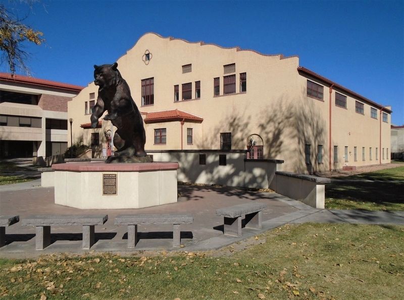
According to Outdoor Life (April, 2004), Old Mose was the most famous grizzly ever to appear in their publication. This one bear was responsible for a myriad of depredations. Known for his distinctive footprint (he was missing two toes on . . . — — Map (db m160761) HM
The only Adams State College football team to
play in a NAIA Division 1 National Championship
Coaching Staff
Head Coach - Jeff Geiser
Assistant Coaches
Lynn Schuett, Chris DeLorenzo, Deano Crumley,
Bill Stone, Dan McMinimee, John . . . — — Map (db m160787) HM
Shortly after its creation in 1921, Adams State Normal School got caught in a political crossfire and received no state funding for construction. But Alamosa residents, quick studies when it came to higher education, raised the money to keep the . . . — — Map (db m160878) HM
The first U.S. citizen known to have seen the site of present-day Alamosa, Lt. Zebulon M. Pike, was arrested nearby in 1807 for trespassing on Spanish soil. But the Spanish were trespassers themselves—the Utes occupied the land. The conflicting . . . — — Map (db m160914) HM
[Map captions, clockwise from top right, read]
• Penitente Canyon [informational]
• Great Sand Dunes National Park [informational]
• Stations of the Cross Shrine [informational]
• The Fort Garland Museum is a . . . — — Map (db m160927) HM
This monument is placed here to preserve the important history of the start of the whole San Luis Valley, by the Denver and Rio Grande Railroad's entrance to Alamosa.
The work train arrived in Alamosa in late 1877, and the first passenger train . . . — — Map (db m160877) HM
Colorado's first home railroad was begun in 1871. William J. Palmer, Civil War veteran and founder of the Denver and Rio Grande, felt that transportation was the key to success in this new, undeveloped land.
"Narrow gauge" railroad was a new . . . — — Map (db m160929) HM
Designated
Landmark
City of Alamosa
Historic Registry
————————————
Dickey-Springer
Post No. 113
American Legion
Laid by
Charles G. Dawes . . . — — Map (db m160804) HM
Emblematic of the courage, fortitude, and vision of those stalwart pioneers and valiant railroad builders who foresaw a great future in the Southwest, this monument is installed to guide the way for posterity in this mighty empire.
The SPMDTU was founded on November 26, 1900, and is the oldest Hispanic civil rights organization in the United States. It was founded in Antonito, by Celedonio Mondragón and six others to fight discrimination in the fields, in the mining . . . — — Map (db m281520) HM
First Lieutenant Thomas C. Bland — Co-Pilot Captain William T. Grimm — Navigator Captain Arthur Galvin — Fire Control Officer Captain Dixon L. Walters — Electronic Warfare Officer Staff Sergeant Damon V. Kanuha — Flight Engineer Staff Sergeant Mark . . . — — Map (db m295632) HM WM
[northwest face of memorial] To challenge social and economic injustice a civil rights movement spread across the USA after World War II. The 1960s and 1970s were prominent years in that struggle. The Chicano Movement became a . . . — — Map (db m295601) HM
[left panel] This is the site of the late “Mexican School” where Hispano-American students were forced to attend, separate from whites, despite being US citizens and being proficient in English. It is also here where Hispano . . . — — Map (db m281521) HM
William H. “Billy” Adams Adams State University's founder and namesake, William H. “Billy” Adams (1861-1954), was a strong advocate for rural education. For a period of 50 years, Billy Adams held several offices in Colorado . . . — — Map (db m294413) HM
The Utes called this valley “Tavi-we-a-gat” or Big Valley. They came here following in the footsteps of their ancestors along this Camino; their dogs pulled their belongings along the now paved byway. This fertile valley provided . . . — — Map (db m71876) HM
You have entered the land of the Río Bravo del Norte, the northernmost outpost of sixteenth century Spain. To the Spanish people, the San Luis Valley was a wild and unexplored place known only to the Native people. Amidst the beauty and towering . . . — — Map (db m71878) HM
Travel the route of these explorers and read Lt. Pike’s own words from his journal.
U.S. Army Expedition to explore the United States new southwest boundary with New Spain.
The men:
Lt. Zebulon M. Pike Dr. John H. Robinson Sgt. . . . — — Map (db m71882) HM
Isolated from the rest of Colorado, the San Luis Valley is often a forgotten place. For Native American tribes including the Utes, Apache, Navajos, and others, this Valley is a source of life - a place where humans and spirit enter and leave . . . — — Map (db m71875) HM
¡Bienvenidos! Caminantes!
Come! Take a walk with us. We know an old song, El Caminante, which tells of taking a long walk along the ancient roads. Like the first prehistoric inhabitants, you too are a ‘caminante’, or one who walks upon . . . — — Map (db m71877) HM
“We can see the Dunes and the Crestone Needles from all over our ranch. When we are lost, that’s what we navigate by.”
--local rancher
Whether traveling on foot, by horseback, Model A, or the . . . — — Map (db m71051) HM
"Totally Unique and Unexpected!"
—park visitor
Welcome to the high elevation desert that is Great Sand Dunes! Does this landscape strike you as amazing, bizarre or totally out of place. If so, you’re not . . . — — Map (db m71050) HM
The scale of the Great Sand Dunes can be difficult to judge. The dunes you see from here are only the front lines of a sea of dunes that covers many square miles.
How far do the dunes extend into the distance? The dunes are 8 miles (13km) . . . — — Map (db m104717) HM
This landscape is the result of dramatic climate changes that affected plants, animals, and humans. In ancient times, large shallow lakes existed on today's valley floor, and American Indians of the Clovis culture pursued great herds of large . . . — — Map (db m160699) HM
In an attempt to settle unknown territory, the Mexican government offered a large gift of land, la merced, for anyone brave enough to attempt to settle the San Luis Valley. Mexican land grants made it possible for even a poor man to . . . — — Map (db m160677) HM
Pioneer conservationist
and founding member
of the Moffat - Hooper - Mosca
Service League for his many years
of dedicated service to the
preservation of the natural beauty
of the San Luis Valley — — Map (db m160692) HM
You have entered the land of the Río Bravo del Norte, the northernmost outpost of sixteenth century Spain. To the Spanish people, the San Luis Valley was a wild and unexplored place known only to the Native people. Amidst the beauty and towering . . . — — Map (db m160674) HM
Travel the route of these explorers and read Lt. Pike’s own words from his journal.
U.S. Army Expedition to explore the United States new southwest boundary with New Spain.
The men:
Lt. Zebulon M. Pike Dr. John H. Robinson Sgt. . . . — — Map (db m160680) HM
29th January. Thursday. Finding the distance too great to attempt crossing immediately to the river, in a direct line, we marched obliquely to a copse of woods, which made down a considerable distance from the mountains. Distance 17 miles. Saw . . . — — Map (db m145393) HM
Different Life Zones Exist in the Mountains
Imagine climbing the mountain in front of you. You might notice it gets cooler as you ascend. As the temperature drops, moisture in the air condenses, precipitation increases, and creates different . . . — — Map (db m71056) HM
On January 27, 1807, U.S. Army Lt. Zebulon Pike and nine soldiers (affectionally called "Dam'd Set of Rascals" by Pike) crossed the Sangre de Cristo Mountains over Medano Pass to enter the territory of New Spain. On orders of his commander, Pike's . . . — — Map (db m160702) HM
You are about to step into the Great Sand Dunes Wilderness. Its mood changes with the seasons, from the spacious solitude of winter, to spring and summer fun and play. Whatever the season of your visit, this unexpected wilderness offers . . . — — Map (db m71057) HM
Mountains and passes were important in the formation
of the sand dunes.
You are looking at the Sangre de Cristo Mountains. Prevailing southwesterly winds carrying sand across the San Luis Valley were blocked by the mountains.
As the . . . — — Map (db m71055) HM
As you travel through these sandy grasslands, notice the bright white surface deposits visible along the highway to the west. The sabkha forms where sand is seasonally saturated by rising ground water. When the water evaporates away in late . . . — — Map (db m160687) HM
You are looking across a sandy grassland that is a vital part of the Great Sand Dunes geological system. The sand sheet lies between the dunefield and the sabkha. Its deepest portions may be remnants of an ancient lake system, but the surface is . . . — — Map (db m160700) HM
¡Bienvenidos! Caminantes!
Come! Take a walk with us. We know an old song, El Caminante, which tells of taking a long walk along the ancient roads. Like the first prehistoric inhabitants, you too are a ‘caminante’, or one who walks upon . . . — — Map (db m160668) HM
Ready or not, with the Treaty of Guadalupe Hidalgo in 1848, Hispano settlers (pobladores) of the San Luis Valley became Americans overnight. The pobladores of the large land grants were legally granted citizenship of the United . . . — — Map (db m160679) HM
On January 28, 1807, Lt. Zebulon Pike and his small band of tattered, hungry, foot-sore soldiers camped near here, having just crossed this snowy Sangre de Cristo Mountains. Under orders from General James Wilkinson to explore the southwestern . . . — — Map (db m71884) HM
Language carries the culture. Read in English, the meanings here may differ from those of the traditional Spanish language of this area. The language, reminiscent of sixteenth century Spain, is a cornerstone of the culture. For half a century . . . — — Map (db m282900) HM
This memorial is the
property of the State of Colorado
Cumbres Pass
Near Continental Divide between the
waters of the Rio Grande and the San Juan
”Cumbres” is Spanish for “Summits”
Altitude 10,022 Feet
Railroad . . . — — Map (db m125500) HM
[Español]Sociedad Protección Mutua de Trabajadores Unidos (S.P.M.D.T.U.) 26 de Noviembre 1900 ————— Los Primeros Oficiales De La Sociedad Protección Mutua De Trabajadores Unidos Celedonio E. Mondragón — Presidente . . . — — Map (db m281555) HM
Deeply rooted in the Catholic religion, the Hispano settlers of the San Luis Valley shared unique spiritual beliefs. On the edge of the frontier, they were extremely isolated with only the occasional priest visiting to administer mass, rites, or . . . — — Map (db m282974) HM
Frederick Fitzjarrald Haberlein (1944-2018), grew up at the Conejos Ranch on the Conejos River just west of Antonito. He graduated from Antonito High School and then attended Colorado State University on an art scholarship where he graduated with a . . . — — Map (db m282918) HM
Because our locomotives are powered by steam, they drink a lot of water.
When the D&RG laid the track, crews built tanks at about ten-mile intervals. The first water tank at Osier was built in 1880. The present tank is a replacement. Both were . . . — — Map (db m282850) HM
The D & RG paid attention to comfort.
Tourists meant revenue and potential new settlers. Ads boasted special excursion trips through the scenic Rockies. In the 1930s, the San Juan refitted its 1880s vintage passenger cars with closed vestibules . . . — — Map (db m282835) HM
“It is believed that the penitente lay fraternity was founded in the 13th century by followers of St. Francis of Assisi in Europe. The practice of penance and strong devotion came to the Western Hemisphere with the Spaniards and made its way . . . — — Map (db m291779) HM
Ranchers relied on the D& RG to ship livestock to Denver, Kansas City, and other markets.
In 1935 alone, shippers ordered 1,087 stockcars, most double-deck sheep cars. From the 1880s until the 1950s, ranchers drove grazing livestock into . . . — — Map (db m282833) HM
You have entered the land of the Rio Bravo del Norte, the northernmost outpost of sixteenth century Spain. To the Spanish people, the San Luis Valley was a wild and unexplored place known only to the Native people. Amid the beauty and towering . . . — — Map (db m293899) HM
Until the railroad arrived, there was no town where Antonito exists today. The Denver & Rio Grande Railroad (D&RG) had originally intended to establish its southern operations in the village of Conejos. Settlers there, some of the earliest to the . . . — — Map (db m282935) HM
The Section House, built in 1881, provided living quarters for railroaders stationed here.
A cook, sometimes the forman's wife, prepared food for everyone at the site. Larger than many on the Cumbres route, Osier's section house had rooms to . . . — — Map (db m282852) HM
Rising Rockies!
The Rocky Mountains started uplifting about 65 million years ago, during what's called the Tertiary Period of the Cenozoic Era.
As they rose, the mountains often fractured along fault lines, which are still visible. About 35 . . . — — Map (db m282827) HM
Antonito grew out of the race to build the first railroad through the southern Rockies. The Denver & Rio Grande Western arrived in 1880, built the town, then kept pushing westward over a rugged, remote stretch of the San Juan Mountains. To save . . . — — Map (db m280799) HM
In a great race to reach the gold and silver mines of Silverton, the San Juan Extension of the Denver & Rio Grande built a railroad over Cumbres Pass. In 1880, a narrow gauge railway was the quickest and cheapest way to transport people and . . . — — Map (db m293898) HM
Once the tracks had been laid through Cumbres Pass toward Chama and Durango, another building crew arrived at Cumbres Pass to construct the facilities the railroad would need to operate its trains. In 1881, a little settlement took shape. . . . — — Map (db m282868) HM
The horse represented more than a new mode of transportation to the American Indian — it represented a new way of life. The animals began filtering north from Spanish settlements in the seventeenth century, and the once-impenetrable great Plains . . . — — Map (db m280794) HM
“Over 100 years ago my uncle, Alejandro Garcia, a rancher, gathered cows near here. He always carried his geologist pick with him on his horse, and given the opportunity, he would stop to investigate the land looking for gold, silver, or other . . . — — Map (db m293897) HM
Fred Warshauer was born in the Province of Posen in 1859 — a part of modern day Germany and Poland. He was Jewish and fled Europe to avoid being drafted into the Prussian army. He lived in poverty until coming to the United States and settling in . . . — — Map (db m282911) HM
¡Bienvenidos Caminantes! Come! Take a walk with us. We know an old song, El Caminante, which tells of taking a long walk along the ancient roads. Like the first prehistoric inhabitants, you too are a “caminante”, or one who . . . — — Map (db m293990) HM
What is a National Heritage Area? A national heritage area is a region recognized by the United States Congress for its unique qualities and resources — natural, scenic, cultural, historic, and recreational. Rich in history, religion, . . . — — Map (db m282922) HM
[left panel] Colorado's vast plains, rugged mountains, and grand plateaus, so magnificent in their beauty and variety, seem at times to overshadow the state's history and people. But look closely. The story of Colorado is . . . — — Map (db m280985) HM
This tract was selected by Bishop Machebeuf, for the first permanent church in Colorado. Here was built a jacal (picket) church, later replaced by a larger church. The first parish of Colorado was erected 100 years ago with Our Lady of Guadalupe as . . . — — Map (db m281594) HM
The bunkhouse provided sleeping quarters for the men who did seasonal track work, snow removal, and improvement to the railroad.
Built in 1880, it was an adjunct to the section house. Some crews were served by bunk and kitchen cars on work trains . . . — — Map (db m282849) HM
We burn coal to boil water to make steam, to drive the pistons, to turn the wheels, to make our locomotives go, go, go!
Coal was the lifeblood of the D&RG and still fuels the C&TSRR. Coal platforms like this one dotted the line. Crews shoveled . . . — — Map (db m282855) HM
Built in 1880, the depot is small because Osier handled very little freight and passenger business. Nevertheless, the agent issued all-important train orders and processed message traffic each day of the year. Furnishing included a telegraph desk, . . . — — Map (db m282863) HM
At 9,637 feet, Osier was one of the D&RG's most remote stations.
As early as 1882, it operated as one of the few open train order telegraph offices along the Cumbres Pass route and was especially busy during stock shipping season and winter snow . . . — — Map (db m282866) HM
Foot paths and unpaved toll roads led early travelers through these mountains prior to the coming of D&RG.
In 1878, Osier marked the halfway point from Conejos, Colorado, and Chama, New Mexico, on the Park View-Ft Garland toll road. You can . . . — — Map (db m282865) HM
How do you turn around on a one-track railroad?
The D&RG used three methods. Tracks configuring a "wye" allowed a locomotive to leave the main line, then back around another curved track to end up heading in the opposite direction. A loop track, . . . — — Map (db m282854) HM
Bob Howsam was born February 28, 1918 in Denver, Colorado. His parents, Lee and Mary, moved the family to La Jara in 1926 to produce honey. Bob was an All Valley basketball player for the La Jara Wildcats in 1936. He attended the University of . . . — — Map (db m294492) HM
District Number 1Organized January 25, 1915, for the betterment of rural education. The first consolidated school in the San Luis Valley. ——— This tablet is the property of the State of Colorado ——— Monument erected by The State Historical . . . — — Map (db m281581) HM
“Swift, deep and wide ran the Río Grande through the San Luis Valley. Untapped by irrigation, crossing the Río Grande was a death defying experience for anyone who attempted it. The 1694 de Vargas entrada is the first record of a Spaniard . . . — — Map (db m294494) HM
“Swift and wide ran the Rio Grande through the San Luis Valley. Untapped by irrigation, crossing the Rio Grande was a death defying experience for anyone who attempted it. The 1694 de Vargas entrada is the first record of a Spaniard successfully . . . — — Map (db m294497) HM
Established in 2006 through an act of Congress, the purpose of the Rio Grande Natural Area is to “conserve, restore and protect the natural, historic, cultural, scientific, scenic, wildlife and recreational resources” of the lower Rio Grande in . . . — — Map (db m294498) HM
This monument is dedicated to Mary Celia Dempsey mother of William Harrison "Jack" Dempsey born June 24, 1895
He fought his way to become
world heavyweight champion on July 4, 1919
and became known as the legendary "Manassa Mauler"
My . . . — — Map (db m80896) HM
In 1878, Mormon pioneers came from the southern states and Utah, settling first at Los Cerritos. In 1879, they organized the town of Manassa, built homes, a school house, and place of worship from native logs. Settlements of Ephraim (1879) and . . . — — Map (db m281593) HM
“In order to survive the Valley's first of many harsh winters, the earliest settlers needed to build shelter quickly. Jacales were constructed by digging a trench, setting vertical posts and covering them with adobe stucco. Annual travelers . . . — — Map (db m291699) HM
Near here, on the banks of the Conejos River, Zebulon M. Pike built a log stockade in early February, 1807, and for the first time raised an American flag over what is now Colorado. Pike's trek of 1806-07 was the second official United States . . . — — Map (db m22701) HM
The D500 is a chain-drive diesel-mechanical locomotive built in Mesita, CO, 25 miles south of Blanca, at the workshops of the Colorado Aggregate Co. during 1954-56. It was designed and built by Channel Wilcox of Denver, CO and George Oringdulph of . . . — — Map (db m281439) HM
Rail transportation reached the San Luis Valley in the form of the narrow gauge Denver & Rio Grande Railway, completed to Alamosa in 1878. The track was standard-gauged in 1899. Meanwhile, efforts to cultivate the Valley demonstrated the soil's . . . — — Map (db m281433) HM
Trails throughout the San Luis Valley tell many stories of those who have lived and visited here. They speak of prehistoric animals, bands of native hunters and gatherers, Spanish explorers, Mexican traders, American soldiers, and many others. . . . — — Map (db m295403) HM
Honoring with Pride Costilla County Veterans
A list of veterans from the Civil War through Operation Desert Shield is engraved on the marker. — — Map (db m64065) WM
This property was presented to the State Historical Society by the Fort Garland Historical Fair Association, which saved the fort for posterity. Established November 30, 1945, as a memorial to the first Colorado settlers, and the U.S. Army troops . . . — — Map (db m281275) HM
This memorial is the
Property of the State of Colorado
———
Fort Garland
United States military outpost
to protect settlers from
hostile Indians. Named for
Brig. Gen. John Garland . . . — — Map (db m22731) HM
Front
The Soldier’s Life
Fort Garland housed infantry and cavalry units. During the 1870’s the famed Buffalo Soldiers—African-American cavalrymen—were also posted here. For all soldiers—and their families—life at Fort Garland was . . . — — Map (db m71032) HM WM
Western expansion and the need to keep peace between settlers and indigenous people fueled the need for frontier forts. Fort Garland was established in 1858, replacing the earlier Fort Massachusetts, just six miles to the north. Five of the . . . — — Map (db m295462) HM
Secured by the U.S. Military from attacks by native peoples, new settlements and mining camps began developing in the San Luis Valley. Long used trails and wagon roads were updated and turned into toll roads. “ 'I had a dream' wrote William . . . — — Map (db m295486) HM
Two U.S. military forts, only six miles apart, on the fringes of the frontier? What gives? Since the early 1800s, Hispano people from northern New Mexico had attempted to settle in the San Luis Valley on land granted from Spain or Mexico. To . . . — — Map (db m295482) HM
What is a National Heritage Area? A national heritage area is a region recognized by the United States Congress for its unique qualities and resources — natural, scenic, cultural, historic, and recreational. Rich in history, religion, . . . — — Map (db m295451) HM
The majestic Sangre de Cristo Mountains facing you, or “La Sierra,” are the life of this community. This land was part of the Sangre de Cristo Land Grant, issued to Narciso Beaubien and Stephen Lee in 1843 by the Mexican government. With . . . — — Map (db m294298) HM
The acequia (ah-say-kya) system, a thriving example of environmentally wise self-government, merges influences from Spain and North Africa. Acequias are long, gently sloping ditches that carry water from rivers and streams to the fields. All . . . — — Map (db m293699) HM
Hispano pioneers founded Colorado's first permanent settlements. Settlers began pushing northward from Taos toward present Colorado in the early 1800s, and in 1844 the Mexican government gave the Sangre de Cristo land grant to two Taos residents. . . . — — Map (db m281598) HM
The oldest continuously used ditch in Colorado, with court decree priority No. 1, and dating from April 10, 1852. Dug by the pioneer settlers of Colorado. Colorado's greatness is built upon irrigation. ——— This tablet is the property of . . . — — Map (db m281600) HM
Located within the National Historic Landmark District of La Plaza de San Luís De La Culebra Listed to the National Register of Historic Places on December 22nd, 1978 — — Map (db m294294) HM
The Sacred Circle Mission Churches lie in Costilla County, Colorado — nestled at the foot of the Sangre de Cristo mountain range. Construction of the nine original historic buildings in the Sacred Circle began in the mid-1850s and continued until . . . — — Map (db m294299) HM
131 entries matched your criteria. The first 100 are listed above. The final 31 ⊳