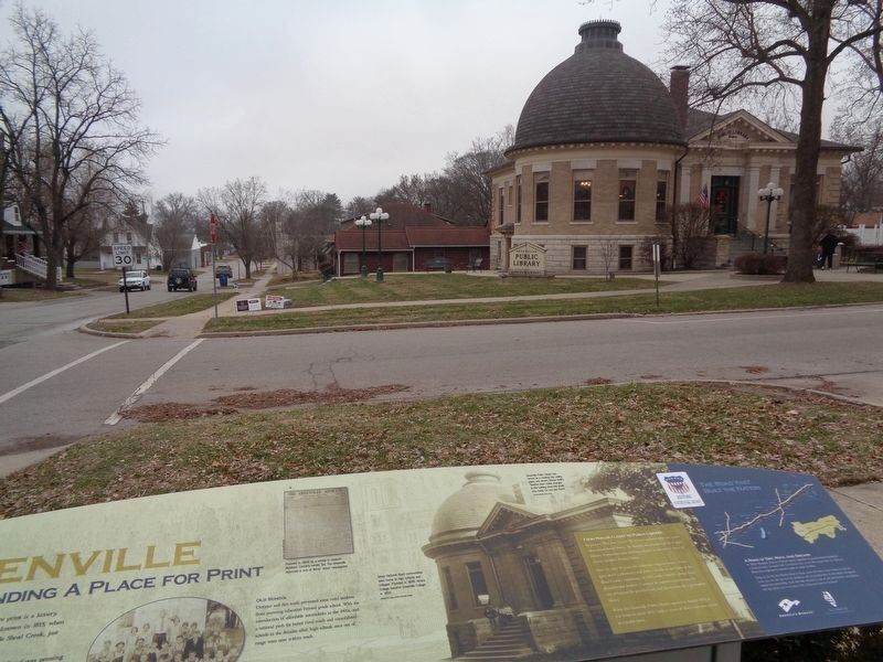
Imagine a world without books--a frontier where print is a luxury, often out of reach. It's the world you would have known in 1815, when George Davidson settled the bluff overlooking Little Shoal Creek, just a short walk from where you stand. . . . — — Map (db m144131) HM
Illinois Confederacy Indians roamed this prairie land, rich in game, which became Illinois County of Virginia. Ceded in 1784 to the United States it was successively included in the Northwest, Indiana; and in 1809, Illinois Territory. Formed in . . . — — Map (db m34169) HM
Built in 1918, this site was headquarters for Wells Judd Tire Sales, a Goodyear Tire Dealer for over 50 years. Managed by Earl Wildermann, it served the local tire and battery trade, as well as customers traveling on the National Trail. Restored in . . . — — Map (db m144108) HM
In the 1820s, not far from where you stand, passengers could board a stagecoach traveling west to Alton, Ill., or east to the Illinois Capitol at Vandalia.
According to local lore, if passengers at the town tavern were waiting for a coach, the . . . — — Map (db m144132) HM
The village square may be quiet today, but from the mid-1800s through the early 1900s, the ring of hammers bending iron and shaping steel echoed down these streets.
Northwest of where you stand, blacksmiths shaped horseshoes, linked chains, . . . — — Map (db m144110) HM
Where the Illinois Central Railroad saw land it didn't need, Henry Hedrick Smith saw opportunity.
In the mid 1800s, Smith, an ambitious outspoken entrepreneur, bought 800 acres of Bond County prairie from Illinois Central. When the St. Louis, . . . — — Map (db m169984) HM
It's a story often told on the National Road. Two towns, both poised to prosper, grow up within walking distance of one another. One thrives. The other fades into the footnotes of history.
In the 1830s, Ewing Chancellor settled land along an . . . — — Map (db m152559) HM
With the opening of the National Road through this area, small communities began to the established along the route, one of which was Casey. The first settler was John Lang, a native of Scotland. Lang and family arrived from Ohio in 1838 and bought . . . — — Map (db m152488) HM
With the completion of the National Road (Cumberland Road) through Clark County in 1834, a settlement known as Cumberland was established in this vicinity. The settlement consisted mainly of workmen who moved here for the purpose of securing . . . — — Map (db m188290) HM
Built at the intersection of Illinois' first state road and America's first federal highway, Marshall was a gateway community for immigrants traveling west. It was founded in 1835 by Illinois Gov. Joseph Duncan and Col. William B. Archer. . . . — — Map (db m152562) HM
This Bridge was completed by Army Engineers sometime between 1834 and 1837 as part of the Old National Road, between Cumberland, Maryland and Vandalia, Illinois, was authorized by the enabling act of 1803 and was the Nation's first federally . . . — — Map (db m71127) HM
This structure was erected in 1841 by Col. Wm. B. Archer, founder of Marshall, and John Bartlett and has been in continuous use as a hotel. It was an important stage coach stop on the early Cumberland Road where many prominent people, including . . . — — Map (db m152564) HM
Imagine you're traveling the National Road in the late 1800s. Your wagon is one of many trundling toward town. The dirt road is rough and the ride uncomfortable, but you welcome the trip. It's a day to visit with friends, catch up on news, and trade . . . — — Map (db m152560) HM
The Linn Family
The ancestors of the Linn Family immigrated from Ireland in 1809. They eventually settled in Parker Township in Clark County Illinois, near Westfield in 1864. Walter Linn and his family moved to Martinsville in the late . . . — — Map (db m242006) HM
[column 1:]
"History of The National Road"
Settlers had been moving west since the early 1700's. By 1802, so many farms and towns had been settled in the Ohio Valley that people living in the territory were calling for . . . — — Map (db m155631) HM
Historic Bridge Re-Created
177 years after the original Jackson Covered Bridge was constructed on this site a new bridge now spans the Embarass River. This structure re-creates as an original covered timber bridge that once stood on this . . . — — Map (db m152477) HM
He was a man of vision. When William C. Greenup co-founded this village in 1834, the land around it was wilderness. But as Illinois Superintendent of the National Road, Greenup saw tremendous potential in the area adjacent to America's highway. . . . — — Map (db m152532) HM
[column 1:]
1830 - Original Jackson Truss Bridge
Excerpts from inspection report made in 1833:
[Doc. No. 117] 23d Congress, 1st Session, HO. Of Reps. War Dept.
May 14, 1834
"Inspection Cumberland Road and its . . . — — Map (db m155370) HM
During the late 1800s, communities on the National Road were watching a new path to prosperity make its way across Illinois. By the time J.W. Conlogue, a superintendent with the St. Louis, Vandalia and Terre Haute Railroad, platted Altamont in 1870, . . . — — Map (db m169991) HM
The National Road, sometimes called the
Cumberland Road or the Old Pike. Ran from
Cumberland, Maryland, to Vandalia, Illinois
the Illinois portion of the road was begun
in 1830 and opened in the summer of 1838
it extended 89 miles from the . . . — — Map (db m161424) HM
From 1871 to 2007, this courthouse was the heart of Effingham County government. For many cities on the National Road, a courthouse promised growth and prosperity. For others, it stood as silent testimony that fortunes change, and promises aren't . . . — — Map (db m152529) HM
In 1870, the St. Louis, Vandalia and Terre Haute rail line replaced the National Road as the fastest, most reliable route across Illinois. Drummers, or traveling salesmen, rode the rails from one town to the next.
At the depot, the drummers' . . . — — Map (db m152531) HM
They traveled West by horse and wagon, oxen and Conestoga, and by foot. They represented a staggering assortment of crafts, talents and trades. They emigrated from Germany in search of affordable land, economic opportunity, and political and . . . — — Map (db m152530) HM
Nearly 100 years before Brownstown businesses offered fuel, food, and lodging to motorists following US 40 across America, there was Ezra Griffith and Twin Pumps.
A New York native, Griffith followed the National Road to Fayette County, Ill., . . . — — Map (db m144228) HM
St. Elmo's history is rooted in the dust of a settlement named Howard's Point. Hamlets like Howard's Point relied on the National Road to sustain their businesses.
Some of these small settlements grew into cities. Others faded as their . . . — — Map (db m144229) HM
Vandalia was the western terminus of the Cumberland or National Road which extended eighty feet wide for 591 miles from Cumberland, Maryland through Pennsylvania, Ohio, and Indiana. Illinois construction by the Federal Government began in 1811 and . . . — — Map (db m42345) HM
N·S·D·A·R Memorial
to the
Pioneer Mothers
of the
Covered Wagon Days
The Cumberland Road.
Built by
the Federal Government.
Was authorized by Congress
and approved by
Thomas Jefferson in 1806.
Vandalia marks the . . . — — Map (db m42341) HM
In 1828 Joseph Shriver surveyed the National Road from Indiana to the Illinois capital at Vandalia. Between the Wabash and Kaskaskia rivers, he found little more than wilderness.
By the mid-1830s, the National Road had spawned settlements in . . . — — Map (db m144226) HM
Come inside and live the story of the Historic National Road, the road that built the nation. Just thirty years after declaring independence from the British, the young nation was feeling the growing pains of westward expansion. President Thomas . . . — — Map (db m144185) HM
Born in Maryland. Clerk of First General Assembly of Illinois Territory, Kaskaskia 1812. Clerk of House of Representatives and of Legislative Council, 1815. Clerk of Constitutional Convention 1818. Secretary of Senate 1818-20. Chief Surveyor of . . . — — Map (db m42374) HM
Imagine Main Street in the early 1900s. Horses pull supply wagons stocked with fruits, vegetables, and dry goods to shops facing the thoroughfare. Trolleys bounce and clang as they trundle down rails at the street's center. Bicyclists weave between . . . — — Map (db m144068) HM
During the era of stagecoach travel, the building before you played an important role. It anchored a relay station.
Coach journeys were broken into stages of about 10 miles. At the end of each stage, drivers stopped at a relay station like . . . — — Map (db m144107) HM
In the mid 1800s, roughly a quarter-mile east of where you stand, Madison County residents carved a settlement from farm fields, prairie grass, broken forests, and the National Road.
Here, the National Road was little more than a scraped-earth . . . — — Map (db m144106) HM
Today, many families find Troy an ideal place to live because of its physical location - close to St. Louis, near Scott Air Force Base and in the midst of the I 55 -70 - 270 exchange.
Early settlers and townspeople found much the same . . . — — Map (db m176313) HM
"It looks like home." That's what Frederick Mersinger might say if he could see the cabin in this park. The building was reconstructed from photos of a log home purchased by Mersinger in 1859. Generations of Mersingers grew up in the house, south . . . — — Map (db m144083) HM
In 1806, President Thomas Jefferson signed legislation creating America's first federal highway. The National Road would join the bustling cities of the East to the resource-rich wilderness of the West, connecting state capitals, county seats, . . . — — Map (db m144040) HM
Between 1880 and 1920, nearly 24 million immigrants arrived in the United States. Many found work in the mines, mills, and factories of America's rapidly expanding industrial sector.
In 1913 American Zinc, Lead and Smelting Company . . . — — Map (db m167916) HM
Brazil, just like her sister US 40 communities, prospered due to its location on the National Road. With the 1926 designation of the National Road as US 40, Brazil instantly became linked with the rest of the nation. Almost every raw material, . . . — — Map (db m233271) HM
Historic National Road
Information on the Move
Information always travels by the best available technology. In the 19th century, the National Road (Main Street, along which you now stand, represented the latest in state-of-the-art . . . — — Map (db m289088) HM
Information always travels by the best available technology. In the 19th century, the National Road (Main Street) along which you now stand, represented the latest in state-of-the-art communications.
Today many of us rely on sophisticated . . . — — Map (db m130948) HM
A waitress named Marge. A red vinyl stool at the counter. The pie case and the bottomless cup of coffee. Diners were America's first fast-food restaurants.
As automobile traffic increased on the National Road in the 1920s, diners sprang up . . . — — Map (db m233274) HM
Constructing the National Road through Indiana in the early 19th century was a monumental task. The road, which crossed the rich soil of Indiana, connected people, wealth, and commerce and linked the state to the rest of the nation.
Increased . . . — — Map (db m233244) HM
Knightstown—first town platted on National Road after survey, 1827—named after noted surveyor Jonathan Knight.
Home of American Communications Network founded, in 1966, to preserve and perpetuate the “Ideals that built . . . — — Map (db m139247) HM
The Capital Commission, meeting near what would become the junction of the National Road and White River, identified the location as the site for the new state capital in 1822. Alexander Ralston and Elias P. Fordham, influenced by Pierre Charles . . . — — Map (db m238989) HM
The American Association of State Highway and Transportation Officials dedicates this brick pathway as its 2000 inaugural Legacy Project, designed to promote the spirit of community and transportation partnership. This Legacy Project commemorates . . . — — Map (db m239047) HM
In 1842 former President Martin Vin Buren was unceremoniously toppled from his carriage on the muddy National Road in Plainfield, Indiana. The Hoosier "welcoming committee" was still angry over his veto of a bill to provide much needed funding to . . . — — Map (db m239039) HM
Sitting at the junction of the National Road and the Wabash River, Vigo County has played a vital role in the transportation of goods to and from Indiana markets. Terre Haute means "high ground" and reflects early French influence in the area. Paul . . . — — Map (db m238840) HM
National Old Trail Road in Wayne County is marked by the 18-foot high Madonna of the Trail statue. The National Road was a primary route for immigration into Indiana and provided access to essential eastern markets for Hoosier companies. Two such . . . — — Map (db m238934) HM
This milestone marks the crossing of the National and Michigan Roads.
Over these roads came many pioneers, who, by their courage and industry founded the great commonwealth of Indiana.
The one hundredth anniversary of the admission of Indiana . . . — — Map (db m174861) HM
Side A National Road in Marion County
Workers built the National Road through this area in the 1830s, nearly four decades before Irvington’s founding.
A constant stream of travelers on the road drew business to the area. The first commercial . . . — — Map (db m174717) HM
An Important Road
The National Road is a true American icon, conceived by George Washington, authorized by Thomas Jefferson, and traveled by Abraham Lincoln.
In 1806 construction of the National Road was approved by the US Congress to . . . — — Map (db m232658) HM
You are standing on Washington Street—the route of the Historic National Road in Indiana. In the early 19th century, this broad street had no sidewalks and was lined with log buildings and frame taverns that crowded near the newly constructed . . . — — Map (db m132794) HM
During westward migration along old National Road, thousands of horses were watered at this widely known public watering place. Town pump and trough maintained as community service by Bridgeport Lodge No. 162, F. & A. M., organized 1854. — — Map (db m174953) HM
"Are we there yet?" For emigrants traveling along the National Road in Indiana, the answer was a resounding "YES!"
Many of us move for the same reasons: new jobs, attractive settings, and nice houses. In the 19th century, thousands moved west . . . — — Map (db m233272) HM
The Historic National Road, begun in 1806, is the nation's first inter-state highway and the first road to be federally funded, stretching from Cumberland, Maryland, to Vandalia, Illinois. This road covers 156 miles across Indiana to link the . . . — — Map (db m260026) HM
The road in front of you was once the most important highway in the United States. Head west and you could go all the way to San Francisco. Head east and you could drive to Atlantic City. Depending on your choice, you'd have the opportunity to . . . — — Map (db m233365) HM
An Important Road
The National Road is a true American icon, conceived by George Washington, authorized by Thomas Jefferson, and traveled by Abraham Lincoln.
In 1806 construction of the National Road was approved by the US Congress to open . . . — — Map (db m233002) HM
U.S. Highway 40, the old National Road which opened the West for settlement, and U.S. Highway 41, a major North-South route, were designated part of the original Federal Highway System in 1926. Their intersection in Terre Haute at Wabash Avenue and . . . — — Map (db m8925) HM
A transportation center, platted 1836 along the Whitewater River, the Cumberland/National Road, and the Whitewater Canal route. Four steam railroads served the town; interurban electric railroad opened 1903. Cambridge City Historic District listed . . . — — Map (db m63949) HM
Built by John Huddleston of bricks made on this farm. Located on the old National Road now U.S. Highway 40.
The house is typical of the architecture of the period.
Pioneers going west in covered wagons found food and shelter here. . . . — — Map (db m152014) HM
(Side One)
The National Road--along which you now stand—arrived here in Centerville in 1832. Centerville was an early "pike town". Regularly spaced about a day's journey apart by wagon, pike towns welcomed travelers and catered to . . . — — Map (db m69309) HM
An Important Road
The National Road is a true American icon, conceived by George Washington,
authorized by Thomas Jefferson, and traveled by Abraham Lincoln.
In 1806 construction of the National Road was approved by the US Congress . . . — — Map (db m139348) HM
N.S.D.A.R. Memorial to the Pioneer Mothers of the Covered Wagon Days.
A Nation's Highway! Once a wilderness trail over which hardy pioneers made their perilous way seeking new homes in the . . . — — Map (db m244) HM
The Madonna of the Trail statue, commissioned by the National Society Daughters of the American Revolution, was designed and sculpted by August Leimbach of St. Louis, Missouri. It symbolizes the courage, faith, and spirit of the pioneer mothers who . . . — — Map (db m138880) HM
One of the most picturesque spots around Cumberland. Discovered by Spendelow after the road over Wills Mountain had been constructed by General Braddock. Adopted as the route of the Cumberland Road (The National Road) 1833. The old stone bridge . . . — — Map (db m187070) HM
A log chapel dedicated to St. Mary was built on this site in 1791. The first parishioners were mostly English Catholics from Southern Maryland. A brick church replaced the log building in 1939. Cumberland became a major center of transportation and . . . — — Map (db m134394) HM
About this sign
The outline drawing above represents the heritage-themed mural to your right. The mural is organized chronologically into sections. Each section is described here, with accompanying historic images..
. . . — — Map (db m259330) HM
In 1749 Christopher Gist, an agent for the Ohio Company, arrived at the junction of the Wills Creek and the North Branch of the Potomac River to erect a trading post. In anticipation of the French and Indian War a fort was constructed in 1754 . . . — — Map (db m139113) HM
Downtown Cumberland
The Flood of March 29, 1924 inflicted almost $5 million worth of destruction in the City of Cumberland. Telephone, telegraph, roads and electric wires were washed away. Though not as bad, another flood occurred on May 12th . . . — — Map (db m252248) HM
The City of Cumberland was established on January 20, 1787, by an act of the Maryland State Legislature. Cumberland began its life as a British fort serving notable figures like George Washington, and it quickly grew to become a thriving town, . . . — — Map (db m310786) HM
The City of Cumberland was established on January 20, 1787, by an act of the Maryland State Legislature. Cumberland began its life as a British fort serving notable figures like George Washington, and it quickly grew to become a thriving town, . . . — — Map (db m310787) HM
The City of Cumberland was established on January 20, 1787, by an act of the Maryland State Legislature. Cumberland began its life as a British fort serving notable figures like George Washington, and it quickly grew to become a thriving town, . . . — — Map (db m310789) HM
The City of Cumberland was established on January 20, 1787, by an act of the Maryland State Legislature. Cumberland began its life as a British fort serving notable figures like George Washington, and it quickly grew to become a thriving town, . . . — — Map (db m310790) HM
The City of Cumberland was established on January 20, 1787, by an act of the Maryland State Legislature. Cumberland began its life as a British fort serving notable figures like George Washington, and it quickly grew to become a thriving town, . . . — — Map (db m310792) HM
The City of Cumberland was established on January 20, 1787, by an act of the Maryland State Legislature. Cumberland began its life as a British fort serving notable figures like George Washington, and it quickly grew to become a thriving town, . . . — — Map (db m310793) HM
Will's Creek Settlement, later known as Cumberland, served as a major gateway for trade, military campaigns against the French, and settlement beyond the mountains in our growing nation. "The New Storehouses" of the Ohio Company were across the . . . — — Map (db m259329) HM
At first, the National Road climbed west from Cumberland up and over Haystack Mountain. In the 1830s, when the road was rebuilt, a new route was chosen. It would be a mile longer but the grade was substantially decreased so that horse teams could . . . — — Map (db m4926) HM
At first, the National Road climbed west from Cumberland up and over Haystack Mountain. In the 1830s, when the road was rebuilt, a new route was chosen. It would be a mile longer but the grade was substantially decreased so that horse teams could . . . — — Map (db m243570) HM
The National Pike was also called the National Road (used national funds) or the Cumberland Road (began in Cumberland). Behind you and to the right along the base of the hill, were the storehouses of The Ohio Company. The earliest trails were made . . . — — Map (db m167058) HM
You are standing at the starting point of this country's first federal road building project, the National Road. A vision of George Washington as a means to develop the continent and to unite the country, his idea was championed by Thomas . . . — — Map (db m17716) HM
You are standing at the starting point of this country's first federal road building project, the Cumberland or National Road. A vision of George Washington as a means to develop the continent and to unite the country, his idea was championed by . . . — — Map (db m310795) HM
The National Road enjoyed a revival from about 1910-1960, with the rising popularity of the automobile. Tourist travel began in earnest when cars became reliable enough for the average person to take a long trip. “Waysiders,” people who catered to . . . — — Map (db m4922) HM
“We this day passed the ‘Aligany’ Mountain (Big Savage Mountain) which is a rocky ascent of more than two miles, in many places extremely steep…”
Captain Robert Orme, June 15, 1755
British General Edward Braddock led a 2,100-man army . . . — — Map (db m177978) HM
Years before St. Michael’s Church was built,
Meshach Frost and his wife Catherine purchased
this property in 1812. When the Frosts bought the
property, construction of the National Road was
already underway. They soon found they were
feeding . . . — — Map (db m3551) HM
The National Road has sustained Frostburg
for almost two centuries. As the road was
being surveyed in 1811, Josiah Frost began
laying out lots. Businesses, serving passing
stagecoaches and wagons, soon lined a
developing Main Street.
By . . . — — Map (db m3553) HM
The National Road has sustained Frostburg for almost two centuries. As the road was being surveyed in 1811, Josiah Frost began laying out lots. Businesses, serving passing stagecoaches and wagons, soon lined a developing Main Street.
By the . . . — — Map (db m199906) HM
Years before St. Michael's Church was built, Meshach Frost and his wife Catherine purchased this property in 1812. When the Frosts bought the property, construction of the National Road was already underway. They soon found they were feeding and . . . — — Map (db m199913) HM
Contrary to popular belief that it was named for its frigid winter weather, Frostburg can trace its history back to 1800 when the community was known as Mt. Pleasant. By the time the National Road (authorized by Congress in 1806) opened through in . . . — — Map (db m167992) HM
Dedicated to
the pioneers who
with heroic sacrifice
and undaunted courage
blazed this old trail
now known as
the National Highway
and thus opened
"The Gateway to the West" — — Map (db m199894) HM
First toll gate house on the old National (Cumberland) Road. Erected about 1833 after this portion of the road was turned over to the State of Maryland by the United States government. There was one other toll gate in Maryland on this Road. — — Map (db m442) HM
Toll houses were built along the National Road as a result of a 25 year national debate as to whether or not the federal government should be responsible for funding road improvements. While there was agreement on the idea that those who used the . . . — — Map (db m443) HM
Toll houses were built along the National Road as a result of a 25 year national debate as to whether or not the federal government should be responsible for funding road improvements. While there was agreement on the idea that those who used the . . . — — Map (db m199902) HM
Toll houses were built along the National Road as a result of a 25 year national debate as to whether or not the federal government should be responsible for funding road improvements. While there was agreement on the idea that those who used the . . . — — Map (db m310806) HM
Was the first of the internal improvements undertaken by the U.S. Government. Surveys were authorized in 1806 over the route of “Braddock’s Road,” which followed “Nemacolin’s Path,” an Indian trail, over which George Washington traveled in 1754 to . . . — — Map (db m167131) HM
The long, winding ascent of Town Hill reaches a height just beyond that of Sideling Hill, but was much more easily crossed. However, early automobiles were still no match for the steep grades and tight turns along this section of the National . . . — — Map (db m20986) HM
The long, winding ascent of Town Hill reaches a height just beyond that of Sideling Hill, but was much more easily crossed. However, early automobiles were still no match for the steep grades and tight turns along this section of the National . . . — — Map (db m199930) HM
355 entries matched your criteria. The first 100 are listed above. Next 100 ⊳