155 entries match your criteria. The first 100 are listed. The final 55 ⊳
MotorCities National Heritage Area Historical Markers
The MotorCities National Heritage Area, designated by Congress in 1998, celebrates the auto industry and its impact on the Detroit area, southeastern Michigan, and communities as far away as Saginaw, Flint, Lansing, and Kalamazoo.
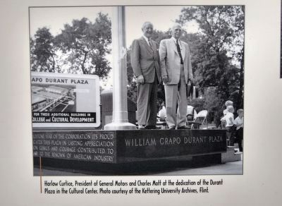
Photo courtesy of the Kettereing University Archives, Flint.
Creating a cultural core for the city,
the Flint College and Cultural Center was established in the 1950s. C. S. Mott donated 36 acres of his land for the complex, which now includes Mott Community College and the University of . . . — — Map (db m143624) HM
Could it be done here?
Hardy was vacationing in Europe when he noticed the advancements being made there in automobiles. Hardy realized the auto's potential in America, but was unable to convince Flint's carriage makers to turn to . . . — — Map (db m143768) HM
Kearsley Street was home to many automotive leaders
through the early decades of the 20th Century. The street was lined with their large Victorian homes, like Whaley House you see here. Dallas Dort and Charles Mott built large country . . . — — Map (db m143842) HM
Josiah Dallas Dort took care of much more than business.
Dort was a founding partner of the Durant-Dort Carriage Company and later a president of Dort Motor Car Company. But he was also actively involved in the Flint Institute of Music, the . . . — — Map (db m180447) HM
Charles Stewart Mott lived for his community.
During his 60 years of service on the General Motors board of directors, he established and endowed the Mott Foundation in 1926 to improve Flint's civic welfare. Mott's generous . . . — — Map (db m234053) HM
Before automobiles were common on American roads, they were found in barns and workshops of tinkerers who explored their mechanics. Judge Charles H. Wisner and Dr. Hiram H. Bardwell, two of Flint's gentleman tinkerers, worked on . . . — — Map (db m224683) HM
The road, cutting across downtown Lansing, was given the name "Olds Freeway' in honor of Ransom E. Olds. The new freeway reflected a national trend as workers moved out of the cities to suburban homes. I-496 spurred growth in the suburbs, but . . . — — Map (db m104215) HM
Following Flint's example, Lansing Amalgamated United Auto Workers Local 182 concluded a successful sit-down strike at Reo in April 1937. A subsequent effort to organize Capital City Wrecking Company resulted in the firing of workers, picket lines . . . — — Map (db m104154) HM
After fire destroyed the new Olds Motor Works plant in Detroit on March 9, 1901, the Lansing Business Men's Association offered Olds land originally acquired in hopes of permanently hosting the State Fair. He took it. His new plant produced only the . . . — — Map (db m104114) HM
P.F. Olds founded a prosperous machine shop here on River Street, repairing and building steam and gasoline engines. His was one of many Lansing Manufacturing plants that produced small engines, carriages, windmills and other equipment used by . . . — — Map (db m104130) HM
Travelers or neighbors, all were welcome here.
Two of the most important roads of Michigan's settlement era - the Monroe Pike (M-50) and the Chicago Road (US 12) crossed at Cambridge Junction. Settlers and stagecoach riders . . . — — Map (db m205428) HM
Everything changed when the trains came to Hamburg in the 1880s.
The village had been connected to neighboring towns only by old Native American trails and dirt roads. Travel was slow and difficult on foot, horse or wagon, and village . . . — — Map (db m168379) HM
The Hotel brought the world to the little village of Hamburg.
Built in 1835 beside Horsehoe Creek, it sheltered many early settlers to the region and, by 1850, visitors coming to enjoy hunting and fishing in the woods and lakes. Two . . . — — Map (db m168152) HM
The Humpback Bridge used to be here,
crossing the Grand Trunk Railway. The narrow wooden span was built in 1900 to carry vehicles on state route M-36 over the Grand Trunk Railway line (now the Lakeland Trail). Unsuited to . . . — — Map (db m202504) HM
Ice harvesting was the major winter activity
in Hamburg Township for over thirty years. Until electrical refrigeration became common in the 1940s, food was best preserved during warmer months in "iceboxes" with ice blocks . . . — — Map (db m202142) HM
Train wrecks were a constant worry
in Hamburg Township, though they were not common. Accidents jolted communities around the world as trains became common in the 1800s. In fact, worldwide time zones were established, in part, . . . — — Map (db m202465) HM
On November 18, 1899 the first electric streetcar arrived in Romeo.
It moved up a track in the center of Main Street, connected by long rods to overhead electrical lines. Later, it turned west on St. Clair Street to the new Detroit United . . . — — Map (db m123383) HM
Romeo's foundry industry was well-established
when Lyman Holmes contacted Ford Motor Company in 1907. Ford was having problems getting engine parts for the Model N automobile from foundries in Detroit. Holmes managed the Romeo Foundry, that . . . — — Map (db m123458) HM
This shop has sheltered many types of work over the years.
Built on its original South Bailey Street site in 1864, its owners included a tinsmith and a furniture upholsterer. Later, blacksmith Clyde Craig worked in the building for 50 . . . — — Map (db m123327) HM
Romeo was a world of wheels, long before the automobile.
In the mid-1800s, a carriage industry developed here which was responsible for much of the prosperity of the Village of Romeo. This is still seen in the beautiful old homes built . . . — — Map (db m123364) HM
There had to be a better way to travel
through the countryside when Michigan was young. In the mid-1800s, the new Gratiot Turnpike between Detroit and Mt. Clemens was a swampy and rutted dirt road. To improve things, in 1846 the State of . . . — — Map (db m120549) HM
During World War II, new cars were not available
and people came to Frenchy's Auto Parts to keep their cars running. Owners Dumitru and Anna Simionescu experienced difficulties — rebuilding from a 1949 fire and financial struggles . . . — — Map (db m120723) HM
Ground was broken here in many ways.
At this site along Gratiot Avenue, Michigan's first commercial airport was established in 1919, and in 1954 Michigan's first shopping center opened here. Packard Motor Car Company, a leading American . . . — — Map (db m120651) HM
Interurban service became the most successful mode of transportation
through Roseville in the early 1900s. Starting in 1895, the Rapid Railway Company ran electric interurbans along Gratiot Avenue between Detroit and Mt. Clemens, a . . . — — Map (db m120631) HM
The outdoor theater was a delightful landmark in Roseville
and in the memories of people who enjoyed the Gratiot Drive-In for 36 years. It first opened in 1948 and offered entertainment until it closed in September 1984. People fondly . . . — — Map (db m120666) HM
Packard is remembered and celebrated
by people around the world. No company sold more luxury cars between 1925 and 1942, and the distinctive tombstone-shaped grill was a company trademark. The Packard Motor Car Company was originally . . . — — Map (db m137591) HM
The Lodge is a landmark, just north of the main gates
of the Packard Proving Grounds. Designed by famous architect Albert Kahn in the English Cotswold style, it opened in 1928 as the site's base of operations. The site manager and his . . . — — Map (db m137579) HM
Packard combined luxury and quality
like no other automobile. The Packard Motor Car Company continually tested its products, even under extreme conditions. Two 25,000-mile tests were run here on the Packard Proving Grounds track, one in . . . — — Map (db m137675) HM
Packard answered the call to arms,
turning its automotive expertise to the production of thousands of trucks and Liberty aircraft engines in World War I. The world again turned to Packard's "Master Motor Builders" during World War II, as . . . — — Map (db m137634) HM
The high-speed testing track was the key.
The 2 1/2-mile oval had 31-degree banked curves which allowed drivers to reach high speeds. On June 14, 1928, after winning that year's Indianapolis 500, race car driver Leon . . . — — Map (db m137683) HM
There were wide open spaces here
when the Packard Motor Car Company purchased almost a full square mile of land to the west for a new testing facility. The site opened in 1928 with a high-speed 2 1/2-mile oval track . . . — — Map (db m137619) HM
The "Master Motor Builders" at Packard
made some of the world's best engines for both automobiles and aircraft. Packard first manufactured aircraft engines during World War I and continued after that war. Packard used the nearly mile-long . . . — — Map (db m137673) HM
It wasn't just an industrial testing facility.
The Proving Grounds was also home to superintendent Charles H. Vincent and his family, from its opening in 1928 to 1942. Charlie and his wife Lucille raised three daughters in the Lodge at the . . . — — Map (db m137605) HM
It has been a building of many uses for many people.
It was built as Clarkston High School in 1910 and students learned and played here until 1930. In recent years, it was a community center and the Independence Township Hall. But in 1940 the . . . — — Map (db m128228) HM
Long before our everyday journeys,
people traveled along this important road. This was once the Grand River Trail, a pathway Native Americans followed across Michigan before European settlement. Farmington founder Arthur Power came here along . . . — — Map (db m85441) HM
Behind these gates lies the country estate
built in 1927 by William E. Scripps, heir to the Detroit News fortune and a talented early aviator, inventor, and radio pioneer. He joined his nephew James Scripps Booth in forming the . . . — — Map (db m133626) HM
This landmark building commands attention
as the Pettibone Creek Hydroelectric Station. It was built in 1938-39 to harness the precious power of water for Ford's Carburetor Plant, now gone. It remains as a reminder of Milford's "village . . . — — Map (db m125348) HM
Henry Ford chose to build a "village industry" here in the 1930s,
one of seventeen small factories he built in rural settings to produce small parts for Ford vehicles. Ford found benefits to building the carburetor plant here — dams . . . — — Map (db m125380) HM
The focus of the Novi community...
the intersection of Grand River Avenue and Novi Road. Various buildings have come and gone, within walking distance of this crossing — stores, churches, a school, a hotel, restaurants, village . . . — — Map (db m155616) HM
A wonderful tumble of attractions grew beside Walled Lake
in the early 20th Century. The lake had been known for fishing, swimming and boating, but the development of automobiles and highways brought great numbers of mobile city dwellers . . . — — Map (db m164432) HM
Novi has grown with major transportation,
and Grand River Avenue has been the community's corridor of history. The route's first segment was cut through the landscape in the 1830s from Detroit to Brighton, and many of Novi's earliest . . . — — Map (db m178336) HM
The crowds loved the high-pitched "shriek" of its engine
and drivers were barely able to control its power. The legendary Novi Special stood out with 450 horsepower at its first Indianapolis 500 race in 1941 and the supercharged engine . . . — — Map (db m155908) HM
An intersection of history...
where the Pere Marquette Railroad crossed Grand River Avenue. Built in the 1850s, Grand River Avenue was an important route between Detroit and Lansing, but transportation was limited to horseback, wagon or . . . — — Map (db m165134) HM
The Michigan State University Tollgate Farm
is the latest in a line of stewards of this precious land. 160 acres were first settled by John and Ervilla Bassett in 1837 here at Twelve Mile and Meadowbrook Roads. The farm grew with access to . . . — — Map (db m164611) HM
The huge dance floor was the center of things
for the people who drove to Walled Lake Casino for forty years. The word "casino" originally meant a large building for civic or entertainment activities, and early automobiles allowed city . . . — — Map (db m164669) HM
It was a destination for all of southeast Michigan
"The Picnic Wonderland," made possible by the automobile and the creation of major highways like Grand River Avenue. Interurban trains didn't travel to Walled Lake, so visitors came in . . . — — Map (db m164752) HM
Beautiful lakes and rolling fertile land
hold quite an attraction. Native Americans first lived in the woodlands among the waterways and trails. By 1820 settlers built roads and opened the land to farming, mostly growing apples and raising . . . — — Map (db m176372) HM
Two railways came together here.
The West Bloomfield Trail follows the path of the Grand Trunk Railroad, built through the region in the 1880s. If you were standing here in 1900, you also would see a light rail trolley line that ran along . . . — — Map (db m174212) HM
The Orchard Lake Museum has been an intersection
where paths cross and people meet. The first building here was a small tavern named the Orchard Lake House, built in 1857 for stagecoach travelers. Various owners rebuilt and . . . — — Map (db m105083) HM
Transportation transformed the landscape of rural West Bloomfield
as electric trolleys and automobiles appeared around the turn of the 20th century. Many people traveled here for the first time from Detroit and Pontiac, and . . . — — Map (db m105114) HM
The trolleys made it easy to travel
through the lakes of Oakland County. In the early 1900s people got off or waited at platforms that were built for access to the track. The Detroit United Railway (DUR) bought land from local . . . — — Map (db m105074) HM
To change directions, trolleys had to turn around.
At this location, at the back of what had been the parade grounds of the Michigan Military Academy, the Detroit United Railway (DUR) built a "wye." This Y-shaped track allowed . . . — — Map (db m105150) HM
Skills, quality and leadership came naturally
to the Fisher brothers. By the time they formed Fisher Body Company in Detroit in 1908, they had adapted their carriage-making to the needs of automobile bodies and were ready for early . . . — — Map (db m174262) HM
Before loan money was available,
the early market for automobiles was limited in Pontiac and elsewhere. Car dealers couldn't afford inventories of more than a few vehicles and many people couldn't afford to buy cars at all. By offering . . . — — Map (db m175272) HM
They built this city.
An exodus of people left southern America for the north in the early 20th Century, attracted by the explosive growth in the automobile industry. Many cam to Pontiac for jobs in the auto plants, and many others brought . . . — — Map (db m175586) HM
Horses did all the work in Pontiac's early days.
By 1850, several builders of "horse-drawn" vehicles — wagons and carriages — had workshops around Lawrence Street, using wood cut at lumbermills powered by the Clinton River. Carriage-makers . . . — — Map (db m174213) HM
"The Corner" was an intersection of people
who came for jobs offered by the explosive growth of Pontiac's automobile industry. In the early 1900s, large numbers of mostly-rural Southerners settled near factories on the southwest side of the . . . — — Map (db m175369) HM
No location has been more vital to the development of modern highways
and the automobile. Built along the Native American Saginaw Trail, Woodward Avenue in the 1800s was the most important pathway of growth between Detroit and . . . — — Map (db m234986) HM
In 1817, Michigan surveyors left their mark, right nearby.
Before Michigan became a state, it was part of the Northwest Territory. To map this unknown terrain, our young federal government dispatched survey crews, to mark off township . . . — — Map (db m173662) HM
A booming automobile industry challenged resources.
The first Daniel Whitfield School was opened in 1852 to meet the needs of Sylvan Lake's children. Four decades later a bigger building replaced this small, one-room wooden schoolhouse. The . . . — — Map (db m173598) HM
They needed and got a good dose of being wanted.
The Detroit Free Press began the Fresh Air Camp in 1906 to give underprivileged Detroit children the experience of two weeks of recreation in the countryside. Most were on their first trips . . . — — Map (db m173562) HM
Many founding members toiled long days
in the early automobile factories to gather $500 to buy this site on Sylvan Lake. The first meetings were held in an old shed used for a boat livery. In 1916 the Boat Club was built with rooms for . . . — — Map (db m173460) HM
Demand for housing began to skyrocket
in the early 1900s as thousands came to southeast Michigan for jobs in the burgeoning automobile industry. Kit homes were an innovative way to help address housing needs. Manufacturers shipped out . . . — — Map (db m173757) HM
Sylvan Lake is called "The Prettiest Little City in Michigan."
Its name means "wooded shady lake" for its unique natural beauty. A trip to Sylvan Lake gave people a new attitude on life. After the 1890s, trolleys and automobiles allowed . . . — — Map (db m175770) HM
Merrill B. Mills had many plans in the early 1890s
for his land around Sylvan Lake. His Sylvan Lake Improvement Association developed lakeside subdivisions and a resort hotel. The Sylvan Lake Inn was built in 1893 on this Point, including a . . . — — Map (db m173569) HM
The world got bigger for most people around 1900
Trolleys and automobiles appeared in southeast Michigan around then, and more people could enjoy distance places. Travel time from Detroit to Sylvan Lake's natural beauty and attractions was . . . — — Map (db m173418) HM
It was a time of exciting change,
as the first automobiles tangled with horses and trolley cars in the streets and countryside. On June 23, 1902 a group of leading businessmen and industrialists came together at the Detroit . . . — — Map (db m105226) HM
Cass Lake was the quiet pleasure
of farmers and merchants until the first trolley rail system was built through the area in 1895, bringing "weekenders" from Pontiac and Detroit to the area. In 1912 real estate developer Joseph . . . — — Map (db m105182) HM
Many Detroiters escaped to nature on the trolleys
of the Detroit United Railway (DUR) in the early 1900s. The Orchard Lake Beach stop was located here, where the parallel Grand Trunk Railroad and DUR trolley tracks crossed . . . — — Map (db m105107) HM
The sparkling lake has been a gift to the generations
Pine Lake Country Club began as a treasured rustic destination for Automobile Club of Detroit road tours in the early 1900s. By 1910, the clubhouse on Pine Lake had become a . . . — — Map (db m105200) HM
The heart of the lake country was well-served by the trolleys
in the early 1900s. No stop in the entire Detroit United Railway (DUR) trolley system was more popular than the Orchard Lake stop located here, where the parallel . . . — — Map (db m105135) HM
The West Bloomfield Trail was once a railbed of the Grand Trunk Railroad, built through the region in the 1880s to serve far-flung agriculture and industry. The light rail electric trolley track that was built in 1899 is noticeable at Cass Lake . . . — — Map (db m174210) HM
The lakes and landscape of Oakland County weren't ready
for the automobile in the early 1900s. Weekend visitors, in noisy "self-propelled" vehicles, churned up dust on unpaved roads and trespassed on private property. To . . . — — Map (db m105049) HM
They turned on their porchlights to signal the bus
to pick them up for the ride to work at the Chrysler plant in Highland Park. In 1939 nine Westacres residents bought a used bus to share the cost of commuting to work. They formed the . . . — — Map (db m175749) HM
Railroad locomotives thundered through this countryside
for more than 130 years. The Michigan Air Line Railroad was completed in 1884, a branch of the historic Grand Trunk Railroad that became a vital shipping network between manufacturing . . . — — Map (db m155852) HM
Born with great purpose in the Great Depression
Westacres endures as a strong West Bloomfield Community. In 1936, U.S. Senator from Michigan, James Couzens pooled $550,000 of his own money with $300,000 of federal funds to establish this . . . — — Map (db m175669) HM
He was a man of vision and achievement,
and he called Haven Hill his "nerve retreat," his restful refuge. The only child of Henry and Clara Ford, Edsel Ford was born in 1893 and became the youngest president of Ford Motor Company in 1919. . . . — — Map (db m99082) HM
Michigan state parks welcomed the newly-mobile drivers
of automobiles in the early 1900s. Genevieve Gillette made it her life's work to preserve precious natural settings and make them available to the travelling public. In 1920 she began . . . — — Map (db m99055) HM
The centerpiece of Edsel Ford's working farm at Haven Hill
was this barn, built in the early 1930s and partially blown down by high winds in 2008. This huge barn was an expression of the merging agriculture and industry, a . . . — — Map (db m203192) HM
It was a garage and a playhouse.
The Carriage House was planned to be the chauffeur's home and to shelter Ford family vehicles. But the chauffeur moved into the Lodge, and the Carriage House became a playhouse for the Ford children — . . . — — Map (db m99117) HM
An expression of deep respect for the land,
this complex was called the Farm Group Buildings. Edsel Ford learned from his father Henry Ford who wrote in 1932 that "with one foot in industry and another foot in the land, human society is . . . — — Map (db m99131) HM
The Gatehouse was the formal entryway
into the 2,422 acre Haven Hill Estate, Edsel Ford's chosen "weekend getaway." While Edsel gathered property for his country estate in the 1920s, Packard Motor Car Company and General Motors bought large . . . — — Map (db m99066) HM
It was an expression of new wealth and mobility
created by the early automobile industry. Twenty years after his father founded Ford Motor Company in 1903, Edsel Ford began buying the hilly property that became his family's rural retreat . . . — — Map (db m99106) HM
They were discovering America, all over again.
In the summer of 1956, over 5,000 Girl Scouts from around the coutry and around the world gathered at Highland Recreation Area for the first Girl Scout Senior Roundup. The aim was to give the . . . — — Map (db m159639) HM
They came from around the world.
In the early 1920s, "weekend jaunts" in automobiles and on new roads brought day travelers to this countryside like never before, and also brought prominent people from around the world. The world of Edsel . . . — — Map (db m99075) HM
A city and industrial complex were born here
at almost the same time. In the 1950s, Ford Motor Company chose the Wixom Road site for a new automobile assembly plant. It had unique advantages, including nearby railroad tracks to use for . . . — — Map (db m159756) HM
Trains came from all directions,
and made Wixom a hub of commerce. In 1871, Willard Clark Wixom founded the village on property at the intersection of planned railroad lines. One line (later named Pere Marquette, now CSX) was built through . . . — — Map (db m136763) HM
This road is a story with many chapters.
On Pontiac Trail people have traveled on foot, on horseback and on wheels, tracing the story of Wixom and southeast Michigan. It was vital in prehistory as a Native American footpath, and in 1828 it . . . — — Map (db m136792) HM
Something had to be done.
Constructed in 1898 and in service for over 75 years, this firehouse combined two separate volunteer fire companies into one centalized fire station. A paid department and a dedicated building represented a major . . . — — Map (db m98474) HM
Manufacturing here spanned most of the 20th Century,
reflecting the changing economy in Ypsilanti and in America. In 1907 the Ypsilanti Hay Press Company first built a factory here by the Huron River and the railroad tracks to make . . . — — Map (db m98955) HM
You can get hungry building B-24 bombers.
The Bomber Restaurant was first given its name in 1942 by Florence Bladwin [sic] Averill. The massive Ford B-24 bomber plant had just opened at nearby Willow Run Airport to supply aircraft . . . — — Map (db m98698) HM
This lovely building has been many homes.
It was built in the Italianate style in 1860, as our nation's Civil War approached, for the family of bank president Asa Dow. It continued as a home for families until 1922. As apartments, it . . . — — Map (db m96994) HM
Along the road, a welcoming tradition.
The road was once called the Sauk Trail, the Military Chicago Road, Congress Road, and, eventually, Michigan Avenue. For travel by foot, horse, stagecoach, truck, or automobile, it has endured as a . . . — — Map (db m98488) HM
The building has stories to tell
It can tell about first being built as an electric plant before being converted to manufacturing in 1905. There are memories of 1916 when it became the first Dodge dealership outside Detroit, later becoming a . . . — — Map (db m94320) HM
The early automotive industry came to Ypsilanti
just after World War I. In 1919, Apex Motor Corporation built a small factory on River Street just south of Michigan Avenue to manufacture various "Ace" vehicles. But by 1925 three . . . — — Map (db m98724) HM
Henry Ford wasn't the first to harness the flowing Huron River.
In the 1880s, dams built along the river through Ypsilanti provided waterpower to mills processing paper, wool, lumber, and grain. In 1931, Ford bought property along the river . . . — — Map (db m98723) HM
It's hard to count all the brands of automobiles
that were sold on the south side of Michigan Avenue. Right here, between the Huron River Bridge and Park Street, 17 auto dealers sold 31 different brands of cars and trucks during the 1900s. . . . — — Map (db m98722) HM
It was America's "first completely new car in fifty years"
and the vision in 1945 of Preston Tucker, who lived at 110 North Park Street in Ypsilanti. He was the general manager of his family's Ypsilanti Machine & Tool Company at 103 North . . . — — Map (db m98420) HM
Canton's loamy soil was a natural draw
to the region's settlers. From 1825 to the 1960s farming was the main vocation in Canton. At first, self-sustaining farms provided the only food and income for a family. By the 1920s, automobiles, . . . — — Map (db m99847) HM
At Cherry Hill Village, Henry Ford did something different.
In front of you, at the southwest corner of Cherry Hill and Ridge Roads, was one of his "village industries," small factory sites which produced Ford parts with special local . . . — — Map (db m99544) HM
155 entries matched your criteria. The first 100 are listed above. The final 55 ⊳