Seminole Wars
1814-1858
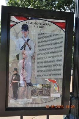
I am Private Pet Younger of the 4th US Infantry Regiment. I joined the Regular Army in November 1835 at age 15. I was specially trained as part of the light infantry company whose main jobs were scouting and . . . — — Map (db m85604) WM
I am Private Darbin Abolt of the 7th US Infantry Regiment, part of which is commanded by Captain Zachary Taylor, our future president. I was already in the Army when we declared war on the British in June 1812. We were fed up with the British . . . — — Map (db m85617) WM
[Written on the initial marker, provided for context]
Our Constitution names the President of the United States the Commander in Chief of all the Armed Forces. Presidents who have served in our military are displayed on the following . . . — — Map (db m92384) HM WM
From the front of his home, John Drennen could overlook the bustling port town of Van Buren, including the wharf originally known as Phillips Landing.
Until after the Civil War, the Arkansas River and the steamboats that plied its . . . — — Map (db m120427) HM
Established in 1849 and named in honor of General Zachary Taylor, after the Rough and Ready Company of miners from Wisconsin, this was one of the principal towns of Nevada County. In 1850, articles of secession were drawn up establishing the . . . — — Map (db m10560) HM
Named for U.S.S. Portsmouth commanded by Capt. John B. Montgomery, after whom Montgomery Street was named. It was here on the plaza that Capt. Montgomery first raised the American flag near the Mexican adobe custom house on July 9, 1846. This plaza . . . — — Map (db m143438) HM
This marker consists of six plaques arranged in a 2 X 3 pattern. The top left plaque is the title plaque and may contain some text. The top right plaque displayed an arrow which points in the direction of the named street. Other plaques contain . . . — — Map (db m72545) HM
Born in Dagsboro, Delaware, 1796. Graduate of Yale College 1815. Member of Delaware House of Representatives 1824. Secretary of State of Delaware 1826-1828. United States Senator 1829-1836, 1845-1849 and 1853 until his death, 1856. Chief Justice of . . . — — Map (db m4748) HM
This historic building lies within a 1,750
acre Duke of York land patent called Saw Mill
Range granted to Henry Bowman in 1680. The
first known resident of this portion of the
tract was Joseph Booth, who purchased 510
acres from the Bowman . . . — — Map (db m37393) HM
Built in 1845 by John M. Clayton (1796-1856) Secretary of State in President Taylor's cabinet. He also served Delaware as U.S. Senator, jurist and Secretary of State. He drafted the Clayton-Bulwer Treaty, which eventually guaranteed that the Panama . . . — — Map (db m146605) HM
On June 10, 1848, Congressman Abraham Lincoln traveled to Wilmington, Delaware, for the purpose of addressing a meeting of members of the Whig political party. He was accompanied by Delaware Representative John W. Houston and two other members of . . . — — Map (db m94199) HM
Settled at the site of a gristmill on Pepper Creek,
this village was originally known as Blackfoot
Town. The present name of the community is
derived from that of John Dagsworthy. A New
Jersey native who moved to this area in the
mid- 18th . . . — — Map (db m37239) HM
Site of
Joshua Tennison's Hotel 1818. John Strother 1821. Basil Williamson 1824. Frederick Barnard 1828. Proprietor of Mansion Hotel, Azariah Fuller American House 1833. City Hotel 1843. Willard's Hotel 1847-1901.
Distinguished Guests . . . — — Map (db m6618) HM
Col. Zachary Taylor had Fort Basinger built in 1837, during the Seminole Wars, on the Kissimmee River 17 miles above its mouth. It was a small stockade which served as a temporary fort and supply station on the line of forts extending from Tampa to . . . — — Map (db m54083) HM
Side 1
Commanded from here, 1838-1840
the United States Army
in the 2nd Seminole Indian War
Erected by the Hillsborough County Historical Commission 1966
Monument restored by Hart with the Streetcar Extension in 2010
. . . — — Map (db m103266) HM
In these woods on Christmas Day 1837, was fought the Battle of Okeechobee, in which a large band of Seminole Indians, under Chief Wild Cat, Alligator, and Sam Jones was routed by a brigade led by Colonel Zachary Taylor, consisting of the First, . . . — — Map (db m97075) HM WM
In this immediate vicinity was the site of Fort Fraser. Established by General Zachary Taylor November, 1837 on his march against the Seminoles culminating in the Battle of Okeechobee. Erected by the Fourth Infantry and garrisoned by the Second . . . — — Map (db m95102) HM
A few miles east of here, on the banks of the Kissimmee River stood Fort Gardiner. Named for Captain George Washington Gardiner who died in the Dade Massacre in 1835. Established December 2, 1837 by Colonel Zachary Taylor on his march to the Battle . . . — — Map (db m212853) HM
1 • Mount Vernon Red Maple Planted in honor of the Founders of the City of Sanford, Florida on February 10, 1992. This red maple has been grown from seeds collected at Mount Vernon, President George Washington's beloved home on the . . . — — Map (db m214875) HM
Located at the mouth of the Steinhatchee River, Deadman Bay was on Spanish maps by the early 1500s. Spanish Conquistador Panfilo de Narvaez came through the area in 1529 followed by Hernando de Soto ten years later. DeSoto crossed the Steinhatchee . . . — — Map (db m67599) HM
This County created by Act of the Legislature Aug. 18, 1905, is named for Jefferson Davis, President of the Confederacy. Born in Kentucky, Davis later moved to Mississippi. He was educated at Transylvania U. and West Point serving 7 years in the . . . — — Map (db m21822) HM
In this cemetery are buried the following eminent Georgians:
JOHN MILLEDGE (1757-1818), Revolutionary officer, Congressman, Governor (1802-1806). He gave the land on which the University of Georgia is built.
GEORGE WALKER CRAWFORD . . . — — Map (db m14871) HM
Taylor County was created by Act of Jan. 15, 1852 from parts of Macon, Marion and Talbot Counties. It was named for Zachary Taylor (1784-1850), 12th President of the U.S., Major-General, Commander of the Army of the Rio Grande. Known as “Old . . . — — Map (db m27232) HM
Singleton had succumbed "Hook and Line" to the Democrats, stated Lincoln in 1854. He and Quincyan James W. Singleton had been fellow Whigs and disciples of Henry Clay. They had campaigned together in 1848 during Whig Zachary Taylor's . . . — — Map (db m150599) HM
"The points you propose to press upon Douglas, he will be very hard to get up to" ):Lincoln letter to Henry Asbury, 1858). Originally a Kentucky Whig, Henry Asbury was one of the founders of the Republican Party in Illinois along with . . . — — Map (db m58753) HM
To commemorate
the establishment of
Fort Edwards
built by
Maj. Zachary Taylor
3rd U.S. Infantry
September, 1814
Abandoned July, 1824 — — Map (db m243906) HM
Much of the nation's history has unfolded along the Mississippi River. During the War of 1812, this location provided a commanding view of the river, and was the site of strategically important forts.
The First Defense
The region's first . . . — — Map (db m243903) HM
In 1832 when Black Hawk and his Sauk and Fox followers returned to Illinois, 1500 mounted volunteers advanced along the banks of the Rock River to capture them. 505 men under Colonel Zachary Taylor followed in supply boats and late at night on May . . . — — Map (db m78266) HM
Lincoln reportedly had a "very defective taste" in hats. At various times he was known to have worn fur caps, straw or palm hats, and broad, low-brimmed wool or felt hats. He is best known for the "plug" or stovepipe hats he wore as a lawyer . . . — — Map (db m48875) HM
Pyrmont. John Wagner built a dam, race and saw mill about a mile South in 1833 and added a grist mill. He sold to John Fisher who sold to John Fetterhoff who built a large frame mill. Joel Wagoner, James Allen, Elias Morkert, J. J. Cripe, Wm. . . . — — Map (db m40455) HM
Two blocks South of this marker
on March 6, 1814, was born
Sarah Knox Taylor
Daughter of
Capt. And Mrs. Zachary Taylor
Miss Taylor married Lieut. Jefferson Davis
at Louisville, Kentucky on June 17, 1835
and died in West Feliciana . . . — — Map (db m23263) HM
This stone marks the site, and commemorates the One Hundredth Anniversary of the Heroic Defense, of Fort Harrison by a small body of United States Soldiers, assisted by the settlers against the Indians.
September 4, 1812
The . . . — — Map (db m58391) HM
Built by Gov. Harrison, Oct., 1811, enroute to Tippecanoe to disperse the Indians at Prophet's Town.
Capt. Zachary Taylor defended the Fort against a savage Indian attack, Sept., 1812.
De-activated in 1822. — — Map (db m19796) HM
Born in New Hampshire and a veteran of the War of 1812, Governor Cass was a skilled maker of treaties.
In 1831 President Andrew Jackson appointed Governor Cass Secretary of War. He later served as Minister to France.
In the mid 1840's, . . . — — Map (db m76578) HM
Marker Front: In 1829, William C. Redfield declared that Davenport lay opposite the future terminus of a “geographical trunk-line route” between the Atlantic and the Mississippi. Nine years later, in 1838, the Iowa Sun and Davenport and . . . — — Map (db m224582) HM
Marker Front: In 1829, William C. Redfield declared that Davenport lay opposite the future terminus of a “geographical trunk-line route” between the Atlantic and the Mississippi. Nine years later, in 1838, the Iowa Sun and Davenport and . . . — — Map (db m224581) HM
This reconstructed infantry barracks, one of two at Fort Scott, serves to remind us of life for an infantry soldier here in the 1840s and 50s.
During wartime, infantry fought on foot, but during peacetime, life in the infantry meant isolation, . . . — — Map (db m36186) HM
"The ax, pick, saw and trowel, has become more the implement of the American soldier than the cannon, musket or sword."
Colonel Zachary Taylor, 1820
In 1836, President Andrew Jackson authorized $100,000 to build a military road from Fort . . . — — Map (db m33939) HM
Delaware, 1st State
December 7, 1787
1609 • Henry Hudson visited Delaware Bay
1638 • Swedish colonists established Fort Christina, Delaware's first permanent settlement, and founded the colony of New Sweden
1655 • Dutch captured New . . . — — Map (db m47214) HM
Home site of John Pollard Gaines.
1795-1857. Fought in War of 1812.
In state legislature, 1825-36.
Major in the 1st Kentucky Cavalry and
an aide-de-camp to Gen. Winfield
Scott, in Mexican war. Elected to
Congress, 1847-49, while prisoner
of . . . — — Map (db m133213) HM
Crittenden HouseThis building, before west portion was added, was home of John J. Crittenden, 1819 until death 1863. Built in 1800 by Doctor Joseph Scott on land once owned by Aaron Burr. In May, 1837, Daniel Webster and family visited here. In . . . — — Map (db m84399) HM
Liberty Hall A National Historic Landmark This Georgian mansion was begun 1796, by John Brown and named for Lexington, Virginia academy he attended. His wife Margaretta and Elizabeth Love began first Sunday School west of Alleghenies in . . . — — Map (db m84387) HM
Born in Dublin he arrived in America c. 1768. Present at 1776 Delaware crossing and battles of Trenton, Princeton, Brandywine, Germantown & Monmouth; wintered 1777-78 at Valley Forge: captured at Charleston 1780 with Lt. Col. Jon. Clark: witnessed . . . — — Map (db m127917) HM
Col. Richard Taylor of Va., veteran of French and Indian War and the Revolution, built original part of "Springfield" ca. 1790. Boyhood home of son "Old Rough and Ready" Zachary Taylor (1784-1850), veteran of 1812 and Black Hawk wars. Mex. War hero . . . — — Map (db m100859) HM
Gen. Zachary Taylor (1784 – 1850), distinguished lifelong soldier and twelfth President of the United States, buried here in family cemetery. Commissioned Lt. in 1808. Served in War of 1812; Black Hawk War, 1832; Seminole War, 1836 – 43. . . . — — Map (db m21405) HM
Campbellsville
First settled about 1800. Town, established by Legislature, 1817, was made seat of government when county was formed. It was named for Adam and Andrew Campbell who with three brothers came from Va., settling on father's land . . . — — Map (db m99229) HM
Three Louisiana men played prominent roles in the Mexican-American War. Though John Slidell was born in New York, he moved to New Orleans in 1819, started a successful law practice, and eventually became an important leader of the Democratic Party . . . — — Map (db m114832) HM
Panel 1 Fifteen years before Americans began fighting each other in the Civil War, they were at war with their neighbors to the south in Mexico. The Mexican-American War began in 1846 and lasted less than two years with the Americans achieving a . . . — — Map (db m114839) HM
In 1825, four military barracks were built to support the U.S. Army arsenal that occupied much of today's Capitol Park. A fifth barrack that completed the pentagon arrangement was built so poorly it was demolished shortly after construction. . . . — — Map (db m96740) HM
To honor
Zachary Taylor
U.S. Army General and twelfth President
of the United States
Known to Americans as
"Old Rough and Ready"
and who lived for a time some 200 yards
southwest of this spot
This marker placed in 1951 by . . . — — Map (db m87482) HM WM
"Old Rough and Ready," America's 12th president, lived on this site in the home pictured above. He called the cottage Buena Vista after his famous 1847 victory in the Mexican War. The pale horse pictured was Taylor's favorite, "Whitey." It would . . . — — Map (db m87824) HM
Corporal, Capt. Thomas Co., LA. Militia, War of 1812. Son of George Kleinpeter who was first to successfully grow sugarcane on these highlands; grandson of Johann George Kleinpeter, the original German settler of 1784, builder of first steam sugar . . . — — Map (db m92837) HM
President Thomas Jefferson negotiated the Louisiana Purchase with French Emperor Napoleon Bonaparte in 1803. The Louisiana Purchase was the largest peacetime land acquisition in U.S. history, containing territory that eventually comprised 15 states. . . . — — Map (db m106110) HM
In April 1864, life along tranquil Cane River was brutally disrupted when the Civil War reached area residents. In an operation known as the Red River Campaign, Union naval and land forces advanced up the Red River valley from occupied portions of . . . — — Map (db m106514) HM
[Panel 1]:
On and near this site since 1718 has centered the military activities of both regular and citizen soldiers of France, Spain, the Confederacy and the United States. On either side were the redoubts forming the “Great . . . — — Map (db m24684) HM
"I trust some future historian will treat this matter as it deserves to be treated, because it is a subject in which the whole country should feel an interest..." Rear Admiral David D. Porter May 16, 1864 Assembling the Troops In March . . . — — Map (db m38368) HM
Established in 1822 under Gen. Zachary Taylor as a major American fort on the southwestern frontier. It later became known as the Cradle of the Mexican War. — — Map (db m106138) HM
The History of the St. Leonard Garden of Remembrance (1990 - Present)
The Original Garden
The Road and Garden of Remembrance began in the spring of 1990 as a project of a committee of the St. Leonard Area Citizens Association . . . — — Map (db m181827) HM
Spanning the Cassleman River and supporting 200 years of hooves, boots, sleigh runners, and wheels of every type and description, the Cassleman River Bridge begins its third century on the National Road in Grantsville, Maryland. It is one of the . . . — — Map (db m135702) HM
Spanning the Casselman River and supporting 200 years of hooves, boots, sleigh runners, and wheels of every type and description, the Casselman River Bridge begins its third century on the National Road in Grantsville, Maryland. It is one of the . . . — — Map (db m167079) HM
[Side 1]
Gateway to the West
The overarching theme in the Heritage Area is Garrett County's relationship to the opening and development of America's western frontier in the late 18th and early 19th centuries. In fact Garrett County is . . . — — Map (db m223083) HM
Nicholas Snowden's mansion was built early in the 19th century on the present site of Pallotti High School. His daughter Louisa was the wife of Horace Capron who was important in developing the Laurel Cotton Mill. The mansion was home for succeeding . . . — — Map (db m128063) HM
The National Road was the first Federally-funded road project authorized by Congress. A gateway to the western frontier, it began in Cumberland and extended to Vandalia, Illinois. Heavily used from the time it opened, it was America's first . . . — — Map (db m148826) HM
The waters off Chatham are notoriously dangerous because of the treacherous shoals and currents. The need for lights to warn mariners was recognized in early days of the country, and in 1806, nine years after the erection of the first lighthouse on . . . — — Map (db m154912) HM
Marker 1 (in front of the Town Hall)
In 1847 Taylor became an independent township named after General Zachary Taylor who later became president. Taylor's first Township Hall was built in 1886 and housed the services of the Township Board, . . . — — Map (db m94612) HM
Appointed by President Zachary Taylor in 1849, Alexander Ramsey came to Minnesota as the territory's first governor. Ramsey stayed in Minnesota for his remaining fifty-four years and, during a successful political career as a Whig and then a . . . — — Map (db m132702) HM
Camp Twiggs was named in honor of Army General David E. Twiggs, the commanding general of the Western Division, the geographical area of the southeast U.S. in 1849. Twiggs replaced Zachary
Taylor when Taylor was elected President in November, 1848. . . . — — Map (db m102359) HM
Round Island is easily seen three miles south of the Pascagoula River entrance. In the summer of 1849 it was the site of an event which drew attendance by soldiers of fortune from all over the South and required intervention by the President of the . . . — — Map (db m122533) HM
The French were the first Europeans to claim this area, clled "Petit Gouffre", "Petit Golphe", "Petit Gulf", or "Little Gulf". In 1763, as a result of the French and Indian War, the area became the dominion of Great Britain. Spain captured British . . . — — Map (db m119887) HM
Troy, laid out on the site of Woods' Fort in 1819, lies on an old Sac and Fox Indian campsite where first settlers Joseph Cottle and Zadock Woods built their cabins, 1801. It was the Sac and Fox tribes, outraged by their 1804 land cession which . . . — — Map (db m138510) HM
This marks the site of
Woods Fort
where the settlers gathered
for protection from the
Indians in the War of 1812.
It was the headquarters
of Lieut. (afterwords President)
Zachary Taylor. — — Map (db m140746) HM
From Frontier to Major City
In the early 1800s, Buffalo was a sleepy village known as New Amsterdam, on the edge of America's then western frontier. Holland Land Company surveyor Joseph Ellicott, inspired by Pierre L'Enfant's radial . . . — — Map (db m92798) HM
The Mexican War increased the nation’s size by over 20 percent and continued the rapid territorial expansion of the United States. In 1846, after a number of incidents along the border between Texas and Mexico, the United States declared war . . . — — Map (db m22277) HM
Born on June 26, 1819 in Ballston Spa, N.Y. he resided in his childhood at a home located at the corner of Washington and Fenwick, a few blocks from here.
He attended schools at Auburn and Cooperstown, NY. He was an 1842 graduate of the . . . — — Map (db m64584) HM WM
In January 1864, General Robert E. Lee wrote to Confederate President Jefferson Davis that "a bold party" could descend the Neuse River to New Bern at night, capture Federal gunboats and use them to assist an assault on Union-held New Bern by a . . . — — Map (db m193703) HM
To honor General Zachary Taylor and all U.S. Soldiers (Dragoons) who served during the Mexican War to preserve U.S. Territory.
May 13, 1846 May 30, 1848 — — Map (db m166190) WM
Side A:
On this site stood the home of Elisha and Polly Mygatt Whittlesey and their ten children. Also here was his law office and a records office that was moved in 1965 to Pioneer Village at the Canfield Fairgrounds. Already an attorney in . . . — — Map (db m65433) HM
Site selected and named 1842, by Gen. Zachary Taylor, later Pres. of U.S. Fort established 1842 by 2nd Dragoons, occupied by several rifle, infantry, cavalry, and artillery companies. Built to protect the Chickasaw and Choctaw Indians from the . . . — — Map (db m81743) HM
During the early 1800's, present Southeastern Oklahoma was a major transportation crossroads. Roads connected Fort Towson in the Choctaw Nation to military installations to the North, South and West. On the Texas side of the Red River, Jonesboro was . . . — — Map (db m52580) HM
Samuel D. Sturgis, born in Shippensburg in 1822, was the son of hat-shop operator "Squire" James Sturgis who later constructed this elegant Greek Revival dwelling. After graduating from West Point in 1846, Samuel Sturgis served under General . . . — — Map (db m120023) HM
WAR OF 1812
(1812-1815) A second war with Great Britain arose over maritime rights. This war forged the US Navy into a capable fighting force. The most prominent American warship was the frigate USS Constitution ('Old Ironsides'), . . . — — Map (db m231985) WM
Carved out of a remote wilderness, McConnellsburg served the flood of travelers heading west in the late 18th century. Taverns, like the Fulton House, sprang up all along the packhorse trail from Philadelphia to Pittsburgh.
Whether by . . . — — Map (db m167242) HM
Indian wigwams, a hickory tree, and a spring - that was old center square "Hickory Town" prior to 1730. In that year, however, significant changes occurred as Andrew and James Hamilton laid out Lancaster Townstead with an open square. Streets . . . — — Map (db m5151) HM
A residence and farm, a stagecoach stop, a tavern, an office building and a museum!
In 1812, Scotch-Irish immigrant Alexander Johnston (who lived to be almost 100 yrs.) began erecting this landmark structure. The stone for the building and . . . — — Map (db m167362) HM
By the fall of 1864, the Civil War was not going well for the Confederacy. The Union invasion of the Deep South continued to ravage both the military and civilian population of the war-torn region. In an attempt to halt the advance, Confederate Lt. . . . — — Map (db m146440) HM
City Recorder of Pulaski
Member, Tennessee State Legislature
Governor of Tennessee 1847 - 1849
United States Minister to Russia 1850 - 1853
Speaker of the Tennessee House of Representatives
A native Giles countian, Neill S. Brown was born . . . — — Map (db m151141) HM
A. Waterproof, Louisiana
Mile 381.0 AHP
This small community was moved four times due to floods and the towns caving banks. The original location is now said to lie in the Mississippi River. During its third washout, a newspaper reported . . . — — Map (db m115163) HM
In May 1846 when war was declared against Mexico, the U.S. Congress authorized the raising of 50,000 volunteer troops to supplement the regular U.S. Army. General Zachary Taylor was quickly inundated with volunteer soldiers arriving at Brazos . . . — — Map (db m35287) HM
Created February 12, 1848
Since 1535 men of all nations of the earth sailed
the blue waters of the Gulf of Mexico to the green
valley of the Rio Grande in search of happiness,
and each found it in his own time and in his own way. . . . — — Map (db m118636) HM
Built 1850 by Wm. C. Douglas, who arrived with Gen. Zachary Taylor during Mexican War.
In 1852 by order of U. S. Congress, first Federal Court in Brownsville was held in back room here by Judge John Watrous.
Recorded Texas . . . — — Map (db m202024) HM
The Port of Matamoros was established in 1824. Commercial cargo, shipped mainly from New Orleans and other U.S. ports, was unloaded at the Port and transported overland to Matamoros, Reynosa, Camargo, Monterrey, and Mier. Mexico maintained a . . . — — Map (db m16542) HM
Marker Front:
Two local companies of volunteers were with Ben McCulloch in San Antonio, Feb. 16, 1861 when U.S. Arsenal was surrounded by Texans and surrender demanded. An encounter in a charged atmosphere which could have become the first . . . — — Map (db m128122) HM
At this site in early days stood the South Plains' most significant trees-- twin hackberry groves, on 1870s trail used by buffalo hunters, surveyors, law officers, and early settlers.
On public domain, the site was unappropriated until mid-1880s . . . — — Map (db m91295) HM
American military leader honored in this county in name of an early town (12 mi. W). Born in North Carolina, Bragg was in Texas in 1840s with army of General Zachary Taylor, to fight in Mexican War.
Made a brigadier general of the Confederacy, . . . — — Map (db m202012) HM
Born in Spanish Florida of a black mother and Seminole father in 1812, John Horse (also known as Juan Caballo, Juan Cavallo, or Gopher John) was a prominent leader of Seminole blacks during the 2nd Seminole War. After a valiant fight alongside . . . — — Map (db m186847) HM
In 1846 Zachary Taylor's army marched from Corpus Christi to the Rio Grande. On March 10, 11, 12, 13, the four regiments in succession camped at this spot on Santa Gertrudis Creek.
War with Mexico over the boundary of Texas began soon. The . . . — — Map (db m117527) HM
Battle road of General Zachary Taylor and largest U.S. Army fielded in first half of the 19th century.
After annexation of former Republic of Texas was approved in 1845, the United States sent Taylor to occupy area below the Nueces—to . . . — — Map (db m118051) HM
135 entries matched your criteria. The first 100 are listed above. The final 35 ⊳