In 1693 the French began construction of Fort Royal to guard the harbour at Placentia. When it was completed in 1703, several batteries and outworks supported the main fortifications. The defences, however, were precariously maintained . . . — — Map (db m78917) HM
English
Cape Spear, Newfoundland’s oldest surviving lighthouse, has served as the chief approach light for St. John’s harbour since 1836. Constructed by local builders Nicholas Croke and William Parker, it consists of a stone towner . . . — — Map (db m79112) HM
English
In 1940, the American and Canadian Joint Board of Defence decided to protect the approaches to St. John’s harbour by installing heavy artillery at Cape Spear. Gun emplacements, magazines, and shelters were constructed by 1941 as . . . — — Map (db m79463) HM
Captain Robert Abram Bartlett
Born in Brigus, Newfoundland, "Captain Bob" followed a
family tradition of life at sea. He commanded the ROOSEVELT
during Peary's arctic expedition of 1905-06, accompanied
Peary to the last relay . . . — — Map (db m289808) HM
Hawthorne Cottage
Probably built in the early 1830's for John Leamon, a local merchant, Hawthorne Cottage was originally located 10 kilometres away. Although an unusual design for Newfoundland, this cottage in the Picturesque . . . — — Map (db m302015) HM
The Brigus Tunnel was built for Capt. Abraham Bartlett
by the Cornish miner John Hoskins during the
summer of 1860. Its purpose was to provide easy
access to the Bartlett wharf which projected into
the deep water at its outer end. Since the . . . — — Map (db m289809) HM
Built for the Reid Newfoundland Company this one storey wooden structure is a fine example of the style used during the early years of the Newfoundland railway. It was used as a station until March 31, 1984 when rail service to
Carbonear was . . . — — Map (db m285964) HM
Former Carbonear Railway Station
This combined freight and passenger station is a rare surviving
example of station design from the heyday of railway
construction under the Reid Newfoundland Company. Built in
1917 on the site . . . — — Map (db m285963) HM
Two plaques are mounted on this monument. English:
Near this site stood the “Mansion House” built between 1621 and 1625 by Captain E. Wynne, resident governor of the Colony of Avalon, for the proprietor, Sir George Calvert . . . — — Map (db m79466) HM
A “Fishing Capital” and Colony
This was one of the first harbours in the New World to be frequented by European fishing ships. From the early 1500s The Pool was well known to the Portuguese, Spanish and French fleets. Ferryland is . . . — — Map (db m79471) HM
A battery of one 9 pdr cannon was erected on this site in 1812. As a protection
against raids by American privateers and was maintained until 1815. — — Map (db m285952) HM
English:
This illustration depicts the burning of a house that once stood at this location and was excavated in the mid-1990s. The large stone fireplace foundation has been left as it was found. The rectangular depression marks . . . — — Map (db m79472) HM
Harbour Grace Court House
During the 19th century Harbour Grace was an important
centre in Newfoundland and for much of this period it
boasted, along with St. John's, one of two court houses in
the colony. The present building, . . . — — Map (db m285954) HM
Born in Ireland, Coughlan, under the inspiration of John
Wesley, segved for ten years as an itinerant preacher in
England. When Charles Wesley challenged the validity of his
ordination by a Greek bishop, he moved, in 1765, . . . — — Map (db m301984) HM
This Queen Anne residence was first built in Brigus for Captain
Azariah Munden whose daughter, Elizabeth, married into the Munn
family of Harbour Grace. Her son Robert and his wife Elizabeth had
the house deconstructed and rebuilt in its present . . . — — Map (db m302009) HM
Transatlantic Flights
Between 1919 and 1937 many pioneer aviators, displaying courage and a spirit of high endeavour, undertook uncharted flights across the North Atlantic. The airfield, built on the summit of this hill by the . . . — — Map (db m301982) HM
On May 20, 1932 Amelia Earhart Putnam became the
World's First Woman Pilot to fly solo across the Atlantic Ocean.
The flight, in a Lockheed Vega, originated at the aerodrome here in
Harbour Grace, Newfoundland.
Statue Inspiration & Funding . . . — — Map (db m302012) HM
At the time of Confederation, Newfoundland and Labrador's education system was significantly behind the standards set in other provinces. Of its 1,187 schools, 778 were one-room structures like Otterbury Schoolhouse. Many had no running water or . . . — — Map (db m301989) HM
Otterbury Schoolhouse was a traditional, one-room educational
institution for Roman Catholic youth in the Riverhead and Ottertiury
areas of Harbour Grace. A wood-burning stove provided heat for the
students and teacher. Students were . . . — — Map (db m302204) HM
This structure-once home to cable-operator Edgar Hopkins - is
one of eight houses commissioned by the Western Union Telegraph
Company after taking over transatlantic cable operations in 1912.
Built by Carbonear-based Saunders and Howell, these . . . — — Map (db m285982) HM
English
Gaillardin Redoubt
Built originally of logs and subsequently of drywall masonry, this small enclosure surrounded by a breastwork was intended to keep an enemy from taking possession of Gaillardia Mountain, which overlooked . . . — — Map (db m78970) HM
English
Welcome to
Castle Hill
National Historic Site of Canada
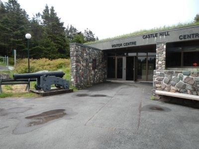
By 1600, France and England dominated the European migratory fisheries to Newfoundland. Small-scale English settlements began in 1610, and in 1662 France . . . — — Map (db m78919) HM
A fort consisting of a semi-circular redoubt mounting twelve guns, a guard house, barracks and storehouse surrounded by a palisade was erected on this site in 1721 and was named after H.R.H. Prince Frederick, then Prince of Wales.
Although the . . . — — Map (db m78918) HM
English
Built in the Vauban style, Fort Royal was designed to protect against attackers with siege artillery and muskets. It contains three demi-bastions and one full bastion. The overlapping faces of the demi-bastions form a flank that . . . — — Map (db m78935) HM
English
Fort Royal, 1709
Following an English naval attack on Plaisance in 1692 the French decided to erect a hilltop fortification to defend the town’s seaward approach. Fort Royal was begun the next year and completed around . . . — — Map (db m79009) HM
This monument includes three panels outlining the history of the Royal Newfoundland Constabulary. Panel 1:
1729-1870 Policing in a Young Colony
Fishing Admiral Justice
The 15th century fishery off Newfoundland was primarily a . . . — — Map (db m79138) HM
Caption, bottom, left (English / French):
The shaded area shows the extent of the 1892 fire. This was the last of several fires that shaped the development of St. John's in the 1800s. / La zone ombrée représente la partie de la ville . . . — — Map (db m79013) HM
This Italianate style building, Newfoundland’s first commercial bank building, constructed in 1849 to the design of Halifax architect David Stirling. The mansard roof was added in 1885. Burnt out and rebuilt after the 1892 fire, it retains a very . . . — — Map (db m79056) HM
This hill was the site of the decisive assault by British troops on the French lines, September 15, 1762, in the last phase of the battle in North America between the forces of Great Britain and France. The victorious attack, led by . . . — — Map (db m78938) HM
Captions, clockwise from the top left. (English / French):
The Cabot Tower’s cornerstone was laid on 23 June 1897 to mark the 400th anniversary of John Cabot’s North American Landfall and the 60th year of Queen Victoria’s reign. The . . . — — Map (db m78971) HM
English
Two adjoining barracks were constructed on this site between 1837 and 1840. The two story complex stretched the length of the present parking lot. It was converted to stores in 1842 because of problems with smoke, cold and . . . — — Map (db m78936) HM
This memorial is dedicated
by
Canadian Marconi Company
to the government and people of Newfoundland to commemorate an outstanding event in the history of Newfoundland and a new era in world communications
The first transatlantic wireless . . . — — Map (db m78920) HM
Captions, clockwise from the top right. (English / French):
St. John’s is both a fishing port and a supply base for the fleets of many countries. / Saint- Jean est à la fois un part de pêche et un centre d’approvisionnement pour les . . . — — Map (db m78972) HM
English
This Italianate style building recalls evolution of banking in Newfoundland, Designed by Halifax architect David Stirling for the Bank of British North America, it opened in 1850 at a time when British investors . . . — — Map (db m79034) HM
English
This remarkable building served as the headquarters and terminus of the Newfoundland railway system. Begun in 1881, the railway played a significant role in the development of the island. Its benefits were evident by the eve of . . . — — Map (db m79109) HM
Built as a Methodist church from plans by English architect Elijah Hoole
after the 1892 Great Fire, it is the third on this site since 1816. Its
Romanesque Revival style with Gothic features is marked by round-arch windows, arched corbels, and . . . — — Map (db m285980) HM
This plaque is dedicated to the memory of
Herbert J. Russell, C.B.E.
Mr. Russell began his carrer with the Newfoundland Railway on September 12, 1906, as an express messenger and stenographer. He rose quickly through various management . . . — — Map (db m79111) HM
Captions, clockwise from the top left. (English / French):Pack Ice, frozen sea water up to 70 cm (27in.) thick, can be present in the waters off St. John’s from February through April. The worst conditions occur in . . . — — Map (db m79011) HM
English
Educator, suffragist, and prominent nursing leader, Mary Southcott led the campaign to professionalize nursing in early 20th-century Newfoundland. Trained in London, England, she founded the St. John’s General Hospital . . . — — Map (db m79031) HM
Built to replace the Long’s Hill Temple destroyed by fire in 1892, the cornerstone of this building was laid by Sir William Whitewall on August 23, 1894. The Temple is the largest brick fraternal lodge in the province, and with its classical revival . . . — — Map (db m79057) HM
For at least 150 years, the arrival of noon hour in St. John’s has been announced by the firing of a gun on Signal Hill. It began as a military time signal, but the practice was continued by the colonial government after the British . . . — — Map (db m79012) HM
This building was constructed for Richard O’Dwyer, a prominent merchant from Waterford, to house his officies and retail stores, but also to accommodate other merchants. With its classically-detailed, granite block facade, the building would have . . . — — Map (db m79061) HM
Caption, top, left (English / French): The importance of Signal Hill to St. John’s goes beyond its guns, signal masts and hospitals. Poet, songwriters and artists alike have celebrated the Hill’s timeless strength. It has become a proud . . . — — Map (db m79014) HM
This plaque is dedicated to the memory of
Sir Robert Gillespie Reid
(1842-1908)
Sir Robert Gillespie Reid was a bridge builder and railway contractor of international fame. Many of the structures that he engineered throughout the United . . . — — Map (db m79110) HM
English
Begun in 1847, under the direction of Bishop Feild, this cathedral was designed by the noted British architect George Gilbert Scott and is an internationally important monument of the Gothic Revival style. Its historical . . . — — Map (db m79058) HM
English
The St. John’s Court House, built 1900-1094, is by far the most striking and elaborate courthouse in the province. Set into a steep hill it commands a dramatic view of the harbour. The Romanesque Revival building was designed by . . . — — Map (db m79032) HM
Captions, clockwise from the top right. (English / French):
Processing seal pelts, St. John’s around 1900. / Transformation des peaux de phoques, Saint-Jean vers 1900.
From 1793 to the early 1980’s, the departure of sealing ships . . . — — Map (db m78974) HM
Built after the 1846 fire, this structure housed a wide range of enterprises including Lash’s Bakery, the Railway Hotel, and McNamara and Thompson, both jewelers. Constructed with a timber frame, stone foundation and a brick exterior, it was among . . . — — Map (db m79059) HM
[English:]
At Signal Hill on 12 December 1901, Guglielmo Marconi and his assistant, George Kemp, confirmed the reception of the . . . — — Map (db m78937) HM
English
Born in Scotland, Carson came to Newfoundland as a physician in 1808, and became an ardent advocate of social and political reform. He was leader in the campaign for an elected legislature, established in 1832, and helped bring . . . — — Map (db m79033) HM
Government House
Built between 1827 and 1831 by the Royal Engineers for Sir
Thomas Cochrane, this building was the official residence
of the governor of Newfoundland until Confederation in
1949, when it became the residence of . . . — — Map (db m285986) HM
This home was built by William Harris in Georgestown - the city's
earliest suburb-beyond the reach of the citywide fires of 1846 and
1892. Harris and his son William were carpenters who erected many
nearby homes. Hon. John Harris, who found . . . — — Map (db m294790) HM
Rennie's Mill Road Historic District
In the aftermath of the city's Great Fire of 1846, Rennie's Mill Road was developed as a residential area where the prosperous residents sought tranquil and safe accommodations away from the . . . — — Map (db m302017) HM
Built atop the foundation of a home that burned in the Great Fire of
1892, this house is representative of the fashionable Second Empire
style residences of the post-fire period. It was once home to Andrew
and Mabel (Payne) Carnell and family. . . . — — Map (db m289796) HM
An integral part of the streetscape of
Queen's Road, this three storey semi-detached house is built of stone with a
brick facade. The building is of architectural note for its use of
masonry in the construction of a private residence, and for its . . . — — Map (db m285955) HM
Thought to have been built in 1804 by militia sergeant James Anderson,
this is believed to be the oldest surviving house in St. John's. Its hipped-roof form was common during the 18th and early 19th centuries.
Conveniently located between Fort . . . — — Map (db m285958) HM
Designed by John E. Hoskins, a local architect and built by the firm
of M. & E. Kennedy for Peter O'Mara. It housed the Peter O'Mara
Drug Store from 1922 and is a good example of the type of drug
store found in St. John's in the late 19th and . . . — — Map (db m289804) HM
One of the oldest buildings in the Rennie's Mill Road National Historic District, originally had a hipped roof which was altered to its present gabled form c1849. In 1927, Sir Marmaduke Winter sold it to W. A. Reid of the Newfoundland Railway. — — Map (db m294787) HM
The threat to Newfoundland's security and to her commerce
that developed during the American Revolution increased the
urgency of completing the fortification of St. John's. Colonel
Robert Pringle of the Royal Engineers, Commandant of . . . — — Map (db m289798) HM
Fort William
Established on this site in 1697, Fort William served as the original
headquarters of the English garrison
in Newfoundland during a period of
intense Anglo-French competition
for colonial power. Commanding
the . . . — — Map (db m289805) HM
This scholarly English lawyer played a pivotal role in
shaping the judiciary system in Newfoundland. On his
recommendation a civil Supreme Court was created in
1791, and then a permanent court with added criminal
jurisdiction in 1792. . . . — — Map (db m289902) HM
A native of Devon and half-brother of Walter Raleigh,
Humphrey Gilbert was one of the first Englishmen to propose
the establishment of colonies in North America. In 1583 as
leader of an expedition to seek a likely place for a . . . — — Map (db m289802) HM
The Newfoundland National War Memorial
Unveiled in 1924, this imposing monument honours the service of Newfoundlanders
and Labradorians during the First World War. Its construction was paid for in part by community fundraising by . . . — — Map (db m286008) HM
This church was built by James Purcell as a satellite chapel for St.
Thomas' Anglican Church in St. John's. Its size and simple design
reflects its once-rural setting. Christ Church was a location in
Canada's first non-silent film, The . . . — — Map (db m289793) HM
While church services were held at Quidi Vidi from an earlier
date, in 1834 Anglicans, Methodists, and Congregationalists combined to build a church here. Co-operation failing, the original
building fell into decay and the property . . . — — Map (db m289794) HM
Mallard Cottage
Built sometime between 1820 and 1840, this picturesque, one-and-one-half storey
cottage was the home of the Mallard family who settled in Quidi Vidi at the
beginning of the 19th century. With its low hipped-roof, . . . — — Map (db m285984) HM
Built for Sergeant James Anderson, this
hipped-roof building is probably the oldest
surviving structure in St. John's and the
oldest house in Newfoundland. It is a good
example of 18th and early 19th century
vernacular house forms. Its . . . — — Map (db m285959) HM
This is the site of the oldest known First
Nations funerary monument in North
America. Dating to the Maritime Archaic
period about 7,700 years ago, the carefully
built mound of rocks over a stone burial
box marked the grave of a young . . . — — Map (db m289807) HM
English:
This mound of rocks is the earliest known funeral monument in the new world and marks the burial place of an Indian child who died about 7500 years ago. The Maritime Archaic people, to whom the child belonged, occupied this area . . . — — Map (db m79551) HM
The concrete foundations near the beach are the remains of a huge diaphone - a fog signal which produces a blast of two distinct tones. When it was installed (in) 1906 the diaphone was the latest in technology. It was operated by compressed air and . . . — — Map (db m79554) HM
The concret ruins which you see here are the remains of the Marconi Wireless Telegraph Station that was built in 1904. Originally constructed for the benefit of trans-Atlantic shipping, the telegraph station became the first major communication link . . . — — Map (db m79552) HM
Tracey has been home to several generations of the Moores Family since the mid-1800s.
This monument marks the location of Ellis & Lillian Moores’s family house. — — Map (db m79543) HM
English:
In the 16th century, the Labrador side of the Strait of Belle Isle emerged as the world's largest producer of whale oil. At its peak, whaling on this coast attracted nearly 2000 Basques annually from Spain and France, and Red Bay . . . — — Map (db m79527) HM
English:
A century of ferry service between Newfoundland and Nova Scotia
SS. Bruce first sailed from this port to North Sydney on 30 June 1898.
French:
En commemoration d’un siècle de service traversier entre . . . — — Map (db m79677) HM
English:
From 1763 to 1767 Captain Cook. R.N directed a survey embracing the greater part of the coast of Newfoundland. The charting of this coastline was the first scientific, large scale, hydrographic survey to use precise triangulation . . . — — Map (db m79672) HM
These five panels outline Captain James Cook’s experiences in Newfoundland. Cook comes to Canada Captain James Cook took his first voyage to Canada as a Master on the vessel ”Pembroke” in February . . . — — Map (db m79676) HM
English:
On December 11th, 1985, Arrow Air Flight MF1285R. a Douglas DC-8-63, US registration N95OJW departed Cairo on an international charter flight to Fort Campbell, Kentucky, USA, via Cologne, Germany and Gander, . . . — — Map (db m79477) HM
Cabot’s Landfall in the New World
In early May, 1497, John Cabot (Giovanni Caboto), a Venetian
citizen bearing letters patent from Henry VII, sailed from
Bristol in the Matthew to seek a western passage to Asia.
On . . . — — Map (db m301879) HM
Built by Ronald Strathie, this hall is thought to be the largest wooden
fraternal hall in Canada. It is home to the Loyal Orange Lodge which,
in the early 20th century, had a local membership of 475. It has also
hosted plays, socials, and . . . — — Map (db m285960) HM
This is an excellent early example of the Carpenter Gothic style that
proliferated throughout Newfoundland and Labrador in the 19th
century. The style is evoked here by tall, lancet-arched windows,
faux buttresses, and spires of wood. A carved . . . — — Map (db m294796) HM
The current railway station building, which once housed the local
telegraph and customs offices was a later addition to the railway
station established by Newfoundland Railway in 1891. The local
Shrine Club took possession of the building in . . . — — Map (db m285961) HM
This wooden Gothic Revival Style building
was built by Allen and Robert Ryder and is
a very good example of the application of
this style to small churches, much of its
interior detail is original, including the curved
scissor-braced roof frame. — — Map (db m285977) HM
Slade’s Room
In the early 1700s a few English fishermen began to settle at Twillingate Harbour, as the French fishery began to concentrate on the area north of Cape S. John (referred to locally as Cape John). In about 1750 John Slade of . . . — — Map (db m79478) HM
These are critically endangered microbial structures. Thrombolites-building micro-organisms resemble the earliest form of life on Earth. These organisms were the only known form of life from 3.5 billion to 650 million years ago. These are some of . . . — — Map (db m79656) HM
English:
In 2000, the global stratotype for the boundary between the Cambrian and Ordovician systems was designated here at Green Point by the International Commission of Stratigraphy. It is located within a bed of shale and . . . — — Map (db m79654) HM
English:
Discovered in 1960, this is the first authenticated Norse site found in North America and could be Leif Ericsson's short-lived Vinland camp. Some time about AD 1000 Norse seafarers established a base here from which they . . . — — Map (db m79611) HM
English:
Following clues in the ancient Icelandic sagas, and the writings of Viking scholars and enthusiasts, Norwegian writer and explorer Helge Ingstad arrived at L’Anse aux Meadows in 1960. When he asked whether there were any unusual . . . — — Map (db m79650) HM
In 1912, a light was established at the south entrance of St. Anthony Harbour replacing the original harbour light placed there in 1906.
The white occulting light was installed in a cast-iron light tower. It exhibited 20.5 meters (67 feet) above . . . — — Map (db m79667) HM
English:
Born in England and trained in medicine, Grenfell gave 50 years of service to the people of northern Newfoundland and Labrador, and became a legend in his own time. He and those he inspired brought medical, spiritual and . . . — — Map (db m79610) HM
St. Anthony Haven
By tradition St. Anthony harbour was named by French explorer Jacque Cartier in 1534. Indeed, it is probable that the long, deep and sheltered harbour was already well-known to fishermen of the French province . . . — — Map (db m79668) HM