By Mike Stroud, October 18, 2011
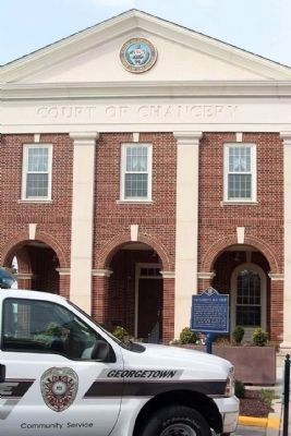
“Pettijohn’s Old Field” Marker with 2011 paint scheme , at the Court of Chancery
GEOGRAPHIC SORT WITH USA FIRST Geographic Sort Title Sort Marker Number Sort Marker Number Sort N Marker Number Sort T Publication Order Sort Publication Order Sort A Erected Year Sort Most Viewed Sort Most Recent-Interest Sort Most Recently Changed Sort SEE FAQ #33 FOR DESCRIPTIONS
On The Circle (U.S. 9) at Bedford Street and Market Street, on the left on The Circle.
On The Circle (U.S. 9) at Bedford and Market Streets, on the left on The Circle.
On The Circle (U.S. 9) at Bedford and Market Streets, on the left on The Circle.
On Savannah Road (U.S. 9) south of Nassau Commons, on the right when traveling south.
On Morris Street at Cubalo Street, on the right when traveling north on Morris Street.
On Eastern Avenue Northeast at Southern Avenue Northeast, on the left when traveling east on Eastern Avenue Northeast.
On Pennsylvania Avenue Northwest at 14th Street Northwest, on the right when traveling east on Pennsylvania Avenue Northwest.
On O Street Northwest west of 29th Street Northwest, on the right when traveling west.
On M Street Northwest east of 34th Street Northwest, on the right when traveling east.
On Rhode Island Avenue Northwest.
On 8th Street Southeast at L Street Southeast, on the right when traveling south on 8th Street Southeast.
Near Kenilworth Avenue Freeway.
Near Boundary Channel Drive. Reported permanently removed.
On Wharf Street Southwest west of District Square Southwest, on the right when traveling west.
On East Oak Street at Brevard Avenue (U.S. 17), on the left when traveling east on East Oak Street.
Paid Advertisement
On North Main Street north of Broad Street (U.S. 98), on the right when traveling north.
Near U.S. 301, 0.2 miles south of East Dr. Martin Luther King Jr. Boulevard, on the right when traveling north.
On Lafayette Street (U.S. 90) at Madison Street, on the right when traveling east on Lafayette Street.
On Jefferson Street (Courthouse Circle) (U.S. 19) at Washington Street (U.S. 90), on the left when traveling north on Jefferson Street (Courthouse Circle).
On West Main Street (U.S. 27) west of North Fletcher Avenue (State Road 51), on the right when traveling west.
On South Monroe Street (State Road 20) at East Jefferson Street (State Road 366), on the right when traveling north on South Monroe Street.
On Fernando Drive at North Meridian Road (State Road 155), on the right when traveling north on Fernando Drive.
Near Main Street south of James Lee Boulevard (U.S. 90), on the left when traveling south.
Near Main Street at West Pine Avenue, on the left when traveling south.
On Northwest 2nd St west of Northwest 3rd Avenue, on the right when traveling west.
Near Universal Boulevard north of Hollywood Way, on the left when traveling north.
Near Universal Boulevard north of Hollywood Way, on the left when traveling north.
Near East Monument Avenue at Lakeview Drive.
Near McIntosh Road, 0.5 miles north of Palmer Ranch Parkway, on the right when traveling north.
Near Interstate 4 at milepost 96,, 2.5 miles east of State Road 434, on the right when traveling east.
Near Interstate 4 at milepost 95 east of State Road 434, on the right when traveling west.
Paid Advertisement
On Ohio Avenue South at Wilbur Street SW, on the left when traveling north on Ohio Avenue South.
On East Washington Street, 0 miles west of North Thomas Street, on the right when traveling west.
On South Main Street (U.S. 441) at West Smith Avenue, on the right when traveling south on South Main Street.
On Dixon Street (State Highway 4) at East 12th Street, on the right when traveling south on Dixon Street.
On Main Street (Georgia Route 51) at Yonah Homer Road, on the left when traveling east on Main Street.
On West Athens Street (Georgia Route 211) at North Broad Street (Georgia Route 11), on the right when traveling east on West Athens Street.
On West Cherokee Avenue at North Erwin Street, on the right when traveling west on West Cherokee Avenue.
Near West Main Street (Georgia Route 113) west of South Public Square, on the right when traveling west.
On Main Street (Georgia Route 293) at Gaston Westbrook Avenue, on the left when traveling north on Main Street.
On South Sheridan Street south of East Central Avenue (U.S. 319), on the right when traveling north.
On South Davis Street (U.S. 129) at East Washington Avenue, on the right when traveling north on South Davis Street.
On Mulberry Street at 2nd Street, on the right when traveling west on Mulberry Street.
On North Second Street at East Dykes Street (Georgia Road 26/112), on the right when traveling north on North Second Street.
On Main Street (U.S. 301) near Brantley Street, on the right when traveling north.
On South College Street (Georgia Route 67) near Courthouse Street, on the right when traveling north.
Paid Advertisement
On East Main Street at Savannah Avenue, on the right when traveling east on East Main Street.
On North Liberty Street (U.S. 25) at Court Street, on the right when traveling north on North Liberty Street.
On West 3rd Street (U.S. 23) at Oak Street, on the right when traveling west on West 3rd Street.
Near McDonough Road, 0.2 miles east of Brookwood Avenue (U.S. 23).
On Bedell Avenue (Georgia Hwy 25) (U.S. 17) at East 4th Street, on the right when traveling north on Bedell Avenue (Georgia Hwy 25).
On West Broad Street (State Highway 46) near Nort Kennedy Street, on the right when traveling west.
On West McIntosh Circle, 2 miles south of Georgia Route 5, on the right when traveling east.
On Okefenokee Parkway (Georgia Route 121) at the road to Traders Hill, on the right when traveling north on Okefenokee Parkway.
On Georgia Route 94, 0.1 miles west of Georgia Route 185, on the left when traveling east.
On Broad Street (Georgia Route 520) 0 miles east of Lafayette Road, on the left when traveling east.
On N Commerce Street (U.S. 27) at W Washington Street, on the right when traveling west on N Commerce Street.
On West Main Street (Georgia Route 205) at South Church Street, on the left when traveling east on West Main Street.
On Washington Street S (Route 39) 0 miles north of Hartford Road (Georgia Route 37), on the right when traveling north.
On West Dame Avenue (U.S. 84) near Smith Street, on the right when traveling south.
On South Park Square NE east of West Park Square NE, on the left when traveling east.
On Memorial Place, 0 miles south of Atlanta Road SE (Georgia Route 3), on the right when traveling south.
Paid Advertisement
On North Main Street (Georgia Route 33) at East Central Avenue, on the right when traveling north on North Main Street.
On North Hutchinson Avenue (U.S. 41) 0 miles south of West 2nd Street, on the right when traveling south.
On East Court Street (U.S. 29) at North Court Street, on the left when traveling north on East Court Street.
On South 7th Street (U.S. 41) 0 miles north of 13th Avenue West, on the left when traveling north.
On Main Street (U.S. 11) at Court StreetAnoth, in the median on Main Street.
On Courthouse Circle, 0 miles west of Eastman Dublin Highway (Georgia Route 117), in the median.
On 2nd Street at Cotton Avenue, on the right when traveling south on 2nd Street.
On Pine Avenue at Champion Lane, on the right when traveling west on Pine Avenue.
On Court Square (Georgia Route 1) at South Main Street, on the left when traveling east on Court Square.
On N. Pine Street near Rabun Street, on the left when traveling east.
On Glynn Street South (Georgia Route 85) at East Lanier Avenue (Georgia Route 54), on the right when traveling north on Glynn Street South.
On Fairburn Campbellton Road near Cochran Road SW, on the right.
On North Fulton Avenue at King Arnold Street, on the left when traveling north on North Fulton Avenue.
On Sandy Springs Circle at Sandy Springs Place, on the right when traveling north on Sandy Springs Circle.
On East Main Street at Palmer Street, on the right when traveling east on East Main Street.
On G Street at Union Street, on the left when traveling east on G Street.
Paid Advertisement
On North Broad Street (Georgia Route 93) at 3rd Avenue NE, on the right when traveling north on North Broad Street.
On North Main Street at Court Street, on the right when traveling north on North Main Street.
On North Clayton Street (Georgia Route 20) 0 miles West Crogan Street (U.S. 29), on the left when traveling north.
Near South Perry Street (Georgia Route 20) at Luckie Street, on the left when traveling south.
On East Atlanta Street (U.S. 78) at Freeman Street, on the right when traveling east on East Atlanta Street.
On North Main Street (U.S. 27) at Broad Street, on the right when traveling north on North Main Street.
On South Irwin Avenue (U.S. 129) at West 2nd Street, on the right when traveling south on South Irwin Avenue.
On Green Street (Georgia Route 53) 0 miles south of Henry Street, on the left when traveling south.
On Washington Street (Georgia Route 53) 0 miles north of Broad Street, on the left when traveling south.
On West Broad Street (U.S. 1) 0 miles east of Green Street, on the right when traveling east.
On East Jackson Street (U.S. 80) at North Jefferson Street (Business U.S. 441), on the right when traveling west on East Jackson Street.
On Leslie Highway (Georgia Route 195) at 4th Street East, on the right when traveling north on Leslie Highway.
On North Ashley Street (U.S. 41) at West Central Avenue (U.S. 84), on the left when traveling north on North Ashley Street.
On Clifton Bradley dr (Georgia Route 90) 0 miles east of Sumter Street (County Route 128), on the left when traveling east.
On McDuffie Avenue, 0.2 miles west of Main Street (U.S. 78), on the left when traveling east.
On South 1st Street (Georgia Route 45) 0 miles north of College Street, on the left when traveling north.
Paid Advertisement
On McEachin Street (U.S. 221) near West Church Street, on the left when traveling south.
On South Main Street (U.S. 278) just east of East Washington Street, on the right when traveling east.
On Old Post Road, 0 miles west of Hill Street, on the right when traveling west.
On Jailhouse Alley south of Main Street (Georgia Road 42), on the right when traveling south.
On West Church Street, 0 miles west of Anderson Avenue, on the right when traveling east.
1791 entries matched your criteria. Entries 101 through 200 are listed above.
⊲ Previous 100 —
Next 100 ⊳