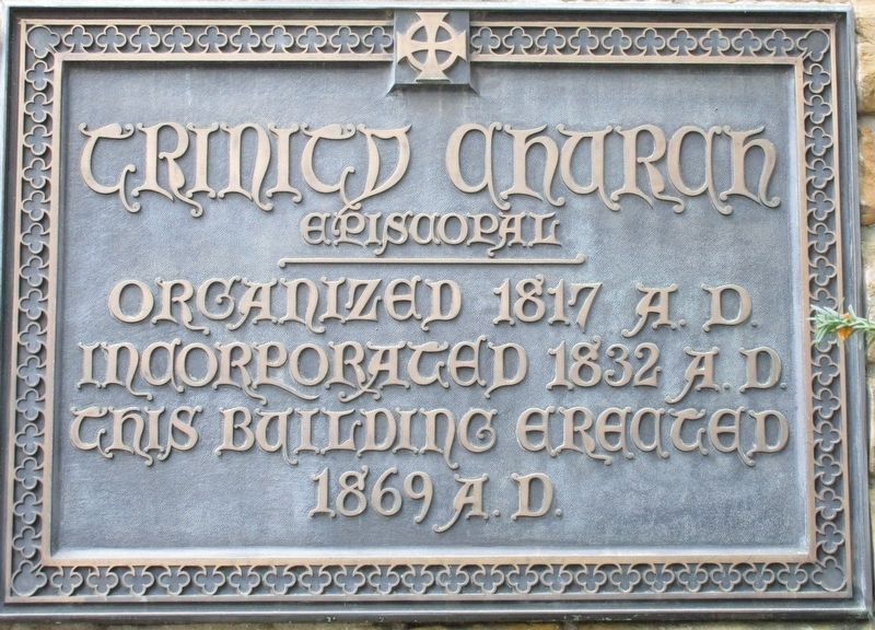
First services of Trinity Episcopal
Church were held May 3, 1817, in the
residence of Dr. Lincoln Goodale,
where later Columbus’ first Sunday
School was founded.
The first church building was built
in 1831 one half block east of High
on . . . — — Map (db m98848) HM
Built on Granville Street in Mid 1800's as manse for Presbyterian Church. Most furnishings are original from Clark family (a founder of Gahanna). — — Map (db m14450) HM
There are two, five-acre farm tracts lying East of this plaque. In 1929 Fred and Georgie Wray acquired one tract and in 1937 the other tract was purchased by their son, Stanley O. Wray Sr. (The original deed dated back to the Virginia Militia) . . . — — Map (db m176240) HM
Built by W.C. Grossman as
the Kingdom Theater for
Mrs. Jessie Köenig.
OLPH owned and celebrated
Mass in the building from
1954 to 1959.
LTOB Players purchased
the building in 1976. — — Map (db m137682) HM
1846 The Highland Mission was built. Lutherans
organized a German and English congregation there
in 1849. Built 1st church one block west in 1853
"St. Johannis Kirche." 1856 St. Paul's Lutheran
(MoSyd) built on this site. About . . . — — Map (db m137707) HM
An architect and educator, Howard Dwight Smith made a significant impact on the built environment of central Ohio. Probably his best-known work is Ohio Stadium, for which he won an American Institute of Architects gold medal in 1921. As OSU's . . . — — Map (db m222261) HM
Born in Derby, Ohio, and raised in Mt. Sterling. Received degree from Ohio University and served in the U.S. Army during WWI. Lived in Upper Arlington for 23 years with wife Helen, son Dan and daughter Joby (Phillips). Established and resided at . . . — — Map (db m222407) HM
Founding pastor of Saint Agatha Catholic Church: the first church built within the young community of Upper Arlington. Developed on 10 acres of swampland and forest at the northern boundary of the village of Upper Arlington in 1940, Saint Agatha . . . — — Map (db m222659) HM
Before places of worship existed in Upper Arlington, early residents traveled to Grandview, Perry Township- even to Columbus by streetcar- to attend worship. It took several years before a truly local option was available.
Riverside United . . . — — Map (db m221824) HM
Senior minister of First Community Church 1935-1956. Pioneered an innovative philosophy known as the "full guidance ministry" to serve the congregation through all the seasons of life. He gained national prominence as a religious leader and was . . . — — Map (db m222192) HM
Born in Portsmouth, Ohio in 1882 the daughter
of a Methodist minister who was a pioneer in
civil rights.
Attended Kings School of Oratory in Pittsburgh
and taught public speaking at Ohio University.
Received honorary degree of doctor of . . . — — Map (db m223610) HM
On this site the Blendon Presbyterian Church held services from 1830 to 1865 on land donated by Edward Phelps to the Blendon Township Trustees for church purposes. — — Map (db m164122) HM
On this site in 1829 the Presbyterians of Blendon Township built their first church. The land was donated by Timothy Lee for “church and burial” purposes. The Reverend Ebenezer Washburn, buried here, was the first minister. The church was destroyed . . . — — Map (db m9567) HM
While many American families defended slavery in the early nineteenth century, Benjamin Hanby’s family did not. Benjamin Hanby was born in July 1833 in Rushville, Ohio to Bishop William Hanby and Ann Miller Hanby. Ben’s father grew up in poverty . . . — — Map (db m107209) HM
This bell came from the Blendon Presbyterian Church (1830-1865) according to William C. Phelps (1881-1967), a great-great-grandson of Edward Phelps Sr. (1759-1840), first settler of Blendon Twp. and donor of the church land at the southwest corner . . . — — Map (db m164096) HM
This church was organized April 22, 1843, in conjunction with The Central College of Ohio on land donated by Squire Timothy Lee. The college, chartered in March, 1842, continued until 1892.
This brick chapel was erected in 1870 under the . . . — — Map (db m18062) HM
Dedicated with love and gratitude
December 19, 1993
to
the Reverend Richard D. Ellsworth
by the congregation of
Central College Presbyterian Church
for more than thirty-five years
of faithful service to the church
and community. — — Map (db m18060) HM
Song writer and minister of the United
Brethren Church, Hanby was an Otterbein College
graduate, class of 1858, known throughout the
world for the inspiring songs, "Darling Nellie
Gray," "Up on the Housetop," and "Who is He
in Yonder Stall." . . . — — Map (db m225380) HM
The first Blendon Presbyterian Church was located at the intersection of Dempsey and Hempstead Roads on what is part of Blendon Central Cemetery. Timothy Lee (1785-1862) donated land at the northeast corner for a church and cemetery. The church . . . — — Map (db m107156) HM
Phelps Acre Park
Dedicated October 24, 2015
We want to express our deep
gratitude to the Central College
Presbyterian Church for loaning us
this historic church bell from one of
Blendon Township’s first Presbyterian
churches and placing it . . . — — Map (db m107161) HM
Saint John's Church of Worthington and Parts Adjacent
In October of 1803, members of The Scioto Company, led by James Kilbourne, came from Connecticut and founded Worthington. On February 6, 1804, the Articles of Agreement establishing St. . . . — — Map (db m12650) HM
In 1897, as the congregation grew, its members decided to construct a
new building. It was located at the junction of County Roads C and 13
just southeast of Wauseon, Ohio. The church had a bell tower and the
bell had two ropes, one for ringing . . . — — Map (db m171978) HM
William and Elizabeth King and their children James, John, Elizabeth, Jane,
Mary, Catherine and William after selling their land holdings in Ireland, were
among the first pioneers in this area, purchasing Section 24, June 4, 1834,
in the Six . . . — — Map (db m171990) HM
William King, a Presbyterian clergyman, of Scottish and
English ancestry, was born in Londonderry, Northern Ireland
and died in Canada at the age of eighty-two. He is buried
in the Maple Leaf Cemetery at Chatham, Ontario, Canada.
The Old King . . . — — Map (db m171989) HM
St. John's Evangelical
Lutheran Church was the first
Lutheran Congregation to
serve the Swanton Area.
It was established in the year
1900 and a one room building
was soon constructed in 1901
to serve as a place of worship.
The congregation . . . — — Map (db m171980) HM
Congregation gathered 1852
Church Dedicated October 18, 1868
Renovated and rededicated:
December 4, 1904
Erected on land donated by Jinks Morey, Universalist and founder of Morey's Corners, now Lyons, Ohio.
Oldest Royalton Township . . . — — Map (db m175858) HM
This cross was built by a member of
Haven Heights Baptist Church, and erected
on 11/3/12 by men of the church. The
cross is the center of our faith and stands
for all to see. Should the cross need to be
replaced; we pray you will erect a . . . — — Map (db m171998) HM
The four stones imbedded in the canopy pillars are inscribed with an
ancient Greek symbol: IHC - the first-three letters of Jesus' name in
Greek. The stones came from our second church, on Clinton Street in
Wauseon. The church no longer exists; . . . — — Map (db m171982) HM
Erected in honor of
Taylor United Methodist Church
1873 - 1980
The congregation of Taylor United Methodist Church and Zion United Methodist Church merged November 30, 1980 — — Map (db m198646) HM
The New Hope Baptist Church was organized around 1860, burned
in 1863, and was rebuilt in the fall of 1864. Once called the
Harris Colored Baptist Church, the edifice’s name “New Hope” was
chosen because it represented the hope of . . . — — Map (db m123142) HM
Side A:
The African Methodist Episcopal Church was organized in 1818 as the Bethel Church. In 1868 its present name, John Gee, was adopted when the church was erected and rededicated at this present site on land donated by Gee. Founders of . . . — — Map (db m30582) HM
On April 1, 1818, six families from the Cilcennin area of Mid-Wales sailed from Aberaeron, Wales to Baltimore. The group of 36 people was led by John Jones Tirbach. From Baltimore they traveled to Pittsburgh and then by flatboats down the Ohio . . . — — Map (db m30501) HM
In November 1843 former slave Frank Lambert, along with 29 other former slaves, purchased 265.5 acres of land in Morgan Township. These African American settlers had once belonged to Charles Lambert Jr. of Bedford County, Virginia, but had been . . . — — Map (db m243194) HM
Founded in 1817, Bainbridge Township was named for Commodore William Bainbridge, commander of the USS Constitution during the War of 1812. The unincorporated hamlet of Bainbridge Center is both the geographic and historic center of Bainbridge . . . — — Map (db m122744) HM
The Burton Congregational Church was organized in 1808 and met in several nearby locations before this present building was erected in 1836 at a cost of $4,000. It was originally located within the park directly opposite where it stands today, but . . . — — Map (db m122754) HM
Side A
The First Congregational Church of Claridon has served the community since it was dedicated in the summer of 1832. Twenty-seven souls from the Burton Congregational Church petitioned to form their own church in Claridon in November . . . — — Map (db m122786) HM
Side A
Called the "Cradle of Equal Suffrage" and "Free Speech Chapel," Union Chapel was to be "...open and free for all denominations, but to be monopolized by no one or to the exclusion of anyone." Built in 1858 or 1859 on land donated by . . . — — Map (db m122751) HM
Built by citizens of South Newbury, Ohio on land donated by Anson Mathews in 1856. This chapel was dedicated to
Free Speech
by
James Abram Garfield
Twentieth President of the United States
Other speakers in this chapel were
Susan B. . . . — — Map (db m122752) HM
Mormon Migration, Kirkland Camp On July 28, 1838, the first and largest company of Mormon pioneers to migrate west camped along the Mad River near this site. Known as Kirtland Camp, the 515 members of The Church of Jesus Christ of Latter-day . . . — — Map (db m97244) HM
Side A:
In the early 1800s, William and Eleanor Kendall owned this land, known for its natural springs, beauty, and farmland. In 1850, Elias Drake, lawyer and former speaker in the Ohio General Assembly, purchased the property and named it . . . — — Map (db m14058) HM
Payne Theological Seminary was originally established as Union Seminary in West Jefferson, Ohio, by the Ohio Conference of the African Methodist Church (AME) on October 18, 1844. The Cincinnati Conference of the Methodist Episcopal Church North met . . . — — Map (db m52891) HM
Left Post1776 1931
James Stevenson donated
the Associate Church †
three acres for church and
cemetery purposes in 1804,
to be known as Massie’s
Creek Church lot and †
cemetery.
The Rev.
Robert . . . — — Map (db m214658) HM WM
Godfrey Brown
1768 1843
“As to debts, thank God
I owe no man anything
but love”
Godfrey Brown was born a slave in
Brunswick County, Virginia in the year
of 1768. He yearned for freedom and
was freed by his master on March . . . — — Map (db m95414) HM
Union Meeting House
Organized in 1807
On this site in 1809, pious Christians from Virginia and North Carolina erected a Methodist Church, the first in Greene County. The church was officially organized on May 23, 1807 as the Bonner Society. . . . — — Map (db m91415) HM
Chartered in 1852 by the Christian Church and later a Unitarian institution, Antioch College opened with educational pioneer Horace Mann as its first president. One of the earliest co-educational colleges in the United States, from its inception . . . — — Map (db m12471) HM
[Side A:] Moncure Daniel Conway
Moncure Daniel Conway was born on March 17, 1832 in Stafford County, Virginia, the son of Walker Peyton and Margaret Daniel Conway. His father was a wealthy slaveholder and prominent state legislator and . . . — — Map (db m13651) HM
On the site of this building Dr. Charles E. Jefferson, internationally known preacher, lecturer & author was born August 26, 1860. An advocate of world peace. — — Map (db m1046) HM
Here the first Methodist Church was organized, 1808, in the home of Thomas Sarchet, leader of the original settlers from the Island of Guersey. — — Map (db m1047) HM
Congregations of the Religous Society of
Friends (Quakers), called “meetings,”
worshipped in plain meeting houses. On
this site stood the last Richland Friends
Meeting House, built in 1872. Ninety-four Friends
established the meeting in 1826 . . . — — Map (db m205417) HM
The Church
Families of Salem settlement first held services in Francis McCormick's log home. When he gave land in 1817 for a church and public school, they built a log church on this site, later replacing it with a brick building. In 1863 the . . . — — Map (db m19922) HM
In the year 1792, Henry Tucker started clearing land and erecting a Station House on the old Indian Trace in what is now the village of Woodlawn. He had purchased the land from John Cleves Symmes for two dollars per acre. Fear of Indian Attack drove . . . — — Map (db m76291) HM
The Byzantine Period was a time of relative peace, during which the Christian populations were consolidated and Christian institutions were established in the Holy Land. The man responsible was Emperor Constantine, who converted to Christianity . . . — — Map (db m201171) HM
The region under the authority of the Eastern Roman Empire after the fall of Western Empire.
[Captions:]
Stone beam from a synagogue at Capernaum
Gold Ring - The design is though to represent the Church of the Holy . . . — — Map (db m201180) HM
Alexander the Great conquered the Holy Land in 332 BCE and extended Greek culture to the region. after his death, Judah became embroiled in the struggle between Ptolomies and the Seleucids; eventually coming under the control of the Seleucids, . . . — — Map (db m201173) HM
This period takes its name from the metallurgic advances that led to the smelting of iron. The Egyptian influenced Canaanite cultures declined, replaced by the Israelites, the "Sea peoples" or Philistines, and the Phoenicians who lived along the . . . — — Map (db m201176) HM
The Arabs took control of the Holy Land in 634 CE, two years after the death of Mohammed. Born in Mecca in 570 CE, he became the most powerful leader in Arabia, enforcing the principles of Islam as the foundation of the Islamic Empire. Mohammed . . . — — Map (db m201170) HM
The Byzantine forces lost control of the area to the conquering Arabs from the Deserts of Arabia under Caliph Umar.
[Captions:]
Ceramic Oil Lamp - The shape is similar to oil lamps during the Byzantine period; however, the . . . — — Map (db m201179) HM
King Cyrus of Persia defeated the Babylonians, allowing religious freedom and the return of the exiles. Some Jews returned, with the Jewish population of Palestine concentrated in Jerusalem.
Many Jews did not return, and this marked the . . . — — Map (db m201174) HM
King of Cyrus of Persia conquered the area of Babylonia and set up a policy of religious tolerance.
[Captions:]
Gold Jewelry - Gold pennants, "The Star of Ishtar". An eight pointed star found at Tel-et Ajjul and the fertility . . . — — Map (db m201184) HM
The Romans controlled the region initially through the leadership of Herod the Great, who was born in the Holy Land, converted to Judaism, fled to Rome, and then returned to govern the region. He made a deep impact on the country with his grand . . . — — Map (db m201172) HM
Aqueducts carry water great distances to areas that do not have their own water supply. Middle Eastern cultures have used them since at least the 10th Century BCE (Before the Common Era).
Early aqueducts — some of which are still in use . . . — — Map (db m201156) HM
During the holiday of Sukkot (sometimes translated as "Tabernacles" or "Festival of the Booths"), the Jewish people remember how their ancestors wandered in the desert for forty years after being driven out of Europe. The Sukkah, or booth, is . . . — — Map (db m201188) HM
Fr. John Henni founded St. Aloysius Orphanage in 1837 to care for German-speaking Catholic children who were left abandoned by the cholera epidemics of the 1830s. The orphanage has occupied its main building since 1856. All of the orphanage’s other . . . — — Map (db m169831) HM
The Society of the Disciples in Carthage (Carthage Christian Church, Disciples of Christ) was organized under the teaching of Pioneer Evangelist Walter Scott in 1832. He is recognized as one of the four primary leaders of the Stone-Campbell . . . — — Map (db m169843) HM
A Neighborhood That No Longer Exists
Cincinnati is a city of neighborhoods. One of them is very, very special—because it is no longer there. The Bottoms: a dense urban neighborhood full of churches, full of people. It ran from the River . . . — — Map (db m24995) HM
In 1817 twenty-two men, including future President William Henry Harrison, chartered Cincinnati's first Episcopal parish, Christ Church. In 1835 members erected a Gothic Revival-style church on this site. The neighborhood evolved as the city grew . . . — — Map (db m171626) HM
Dedication of Sanctuary - April 11, 1875
(Second Presbyterian Church)
Entered in the
National Register of Historic Places
1973
Sanctuary Rededicated - April 11, 1975 — — Map (db m201202) HM
The first church of public worship
in Cincinnati stood on this site
100 feet north of Fourth Street facing Main Street
built in 1792
the Reverend James Kemper served as first pastor — — Map (db m239192) HM
This historic synagogue symbolizes the work of one of the most important figures in nineteenth-century American Jewry, Isaac Mayer Wise (1819-1900). The Bohemian-born rabbi's many achievements include the establishment of the Union of American . . . — — Map (db m24089) HM
On this property in 1831 Bishop Edward Fenwick established a college known as the Anthenaeum and placed it under the patronage of St. Francis Xavier.
In 1840 his successor, Bishop John Baptist Purcell, gave the College to members of the . . . — — Map (db m42659) HM
The Clifton location of Jewish Cemeteries of Greater Cincinnati was founded in 1848, as a resting place for deceased members of Congregation Ahabath Achim, an Orthodox Jewish congregation that later merged with Shearith Israel, and then with Isaac . . . — — Map (db m187352) HM
Hebrew Union College (HUC), founded in Cincinnati in 1875, is the oldest institution of higher Jewish learning in the United States. Its founder, Rabbi Isaac Mayer Wise (1819-1900), was a leading proponent of Reform Judaism in America. In 1950, the . . . — — Map (db m24847) HM
Dr. Jacob Rader Marcus (1896-1995), pioneering historian of the American Jew, founded the American Jewish Archives (AJA) in Cincinnati in 1947. In the aftermath of World War II and the brutal destruction of European Jewry, Marcus anticipated the . . . — — Map (db m24849) HM
Columbia Baptist Cemetery
On the higher ground at the end of this lane
is Columbia Baptist Cemetery, the last
resting place of many of the pioneers who
came with Major Benjamin Stites and founded
Columbia, November 18, 1788, the first . . . — — Map (db m134948) HM
The first meetinghouse of the Columbia Baptist Church- the earliest in Ohio- stood on this site.
In 1787, Captain Benjamin Stites traveled down the Ohio River with supplies to assist the new settlements in Kentucky. Captain Stites ventured across . . . — — Map (db m135250) HM
to the Pioneers
landing near this spot, Nov. 18,1788
The Baptists
of Columbia Township, in 1889
erect this pillar to commemorate the heroism and piety
the first Baptist pioneers of 1788- 90
the first church in the Northwest territory was . . . — — Map (db m135215) HM
Pilgrim Chapel began as a mission of the First Presbyterian Church in 1882. It was originally located in downtown Cincinnati. The Church was moved to Mt. Adams and has served the Protestant Community since its dedication on May 1, 1886. Catholics . . . — — Map (db m113312) HM
built in 1859, was constructed from stone quarried from the slopes of Mt. Adams. Early it was known as the "Archbishop's Church" in honor of Archbishop Purcell (1800-83) who donated the land and supervised construction. It was conceived as a votive . . . — — Map (db m112918) HM
Good Friday Tradition
Beginning in the 1860's, the faithful would climb the Mt. Adams hill to the Holy Cross Immaculate Church (formerly the Church of Immaculate Conception), believing it would be a remembrance of Jesus' ascent of calvary. . . . — — Map (db m187231) HM
Side A: Cincinnati Public Markets
Public markets housing butchers, fish merchants, and produce vendors were once the primary source of perishable foods for residents of America's cities. Cincinnati operated nine in 1859. Only Findlay Market, . . . — — Map (db m24814) HM
St. Mary's Church, Over-the-Rhine, is the oldest house of worship still standing in Cincinnati. German Catholic immigrants founded the parish in 1840, and laid the cornerstone on the Feast of the Annunciation, 25 March 1841. The church was . . . — — Map (db m202775) HM
Founded by Saint Elizabeth Bayley Seton in Maryland in 1809, the Sisters of Charity arrived in Cincinnati in 1829 to open a school and an orphanage, becoming the first permanent establishment of Catholic sisters in Ohio. In 1852 the group separated . . . — — Map (db m227793) HM
Old Clough Church Yard
Here there is no bell peeling
No vaulted tower
Only the crumbling walls
and a spring flower
No prayer is heard
No audible word
Only the winds singing
And heartbells ringing
April has come . . . — — Map (db m238383) HM WM
The Lanes,
Baptist merchants from New Orleans, and the Kempers,
a Presbyterian family from Cincinnati,
gave money and land respectively for Cincinnati's first manual labor theological seminary and high
school,
which opened in suburban . . . — — Map (db m171880) HM
Side A Camp Joy was born at the site of Seven Hills Neighborhood House and original location of St. Barnabas Episcopal Mission Church. Displacement and loss caused by Ohio River flood of 1937 inspired St. Barnabas’ rector and his wife, . . . — — Map (db m134938) HM
Chestnut Street Cemetery. Chestnut Street Cemetery is the first Jewish cemetery in Ohio and the earliest west of the Allegheny Mountains. It was established in 1821 when Nicholas Longworth sold land to Joseph Jonas, David I. Johnson, Morris . . . — — Map (db m243113) HM
George Washington Williams was born in 1849 in Bedford, Pennsylvania. At age 14, he enlisted in the Union Army to fight in the Civil War and received a medical discharge in 1868. In 1874, he became the first African American to graduate from the . . . — — Map (db m25125) HM
This bell was originally placed in the church erected on this site in 1884. Past records indicate that the bell was purchased by the children bringing their pennies as a gift to God on Sunday morning. The bell served the congregation until a new . . . — — Map (db m180850) HM
Since 1839, the Mt. Healthy Christian Church (established as the Church of Christ at Mt. Pleasant) has served as a model for global ministry and missions for Disciple of Christ churches emerging from the actions of the Restoration (Stone-Campbell) . . . — — Map (db m180797) HM
The Sisters of Notre Dame de Namur (SNDdeN). The Sisters of Notre Dame de Namur were founded in 1804 by Saint Julie Billiart to spread the message “Ah, how good it is to serve God.” In 1840, at the request of Bishop John B. Purcell in 1840, the . . . — — Map (db m227783) HM
In the month of May, 1831, a group of emigrants from the Odenwald region of Germany started on the 400 mile trip through Darmstadt and Kassel to Bremen, where they finally sailed for America in late July. They severed all ties that bound them to . . . — — Map (db m158918) HM
The University of Findlay with its founding partners, the Churches of God, General Conference, and the citizens of Findlay, Ohio, celebrates 125 years of tradition and excellence in higher education. — — Map (db m228466) HM
Incorporated in 1882, Findlay College first opened for classes on September 1, 1886. This bell, weighing 1,522 pounds and costing $251, was ordered from McShane's Bell Foundry in Baltimore, Md., by the first president of Findlay College, the Rev. . . . — — Map (db m228467) HM
633 entries matched your criteria. Entries 201 through 300 are listed above. ⊲ Previous 100 — Next 100 ⊳