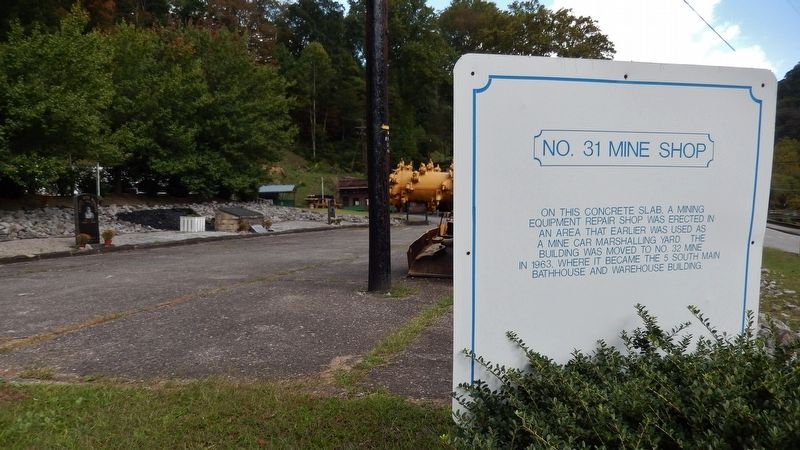
On this concrete slab, a mining equipment repair shop was erected in an area that earlier was used as a mine car marshalling yard. The building was moved to No. 32 Mine in 1963, where it became the 5 South Main Bathhouse and Warehouse building. — — Map (db m121692) HM
This building once housed boiler operated generators which furnished electric power to operate No.'s 30 & 31 mines and support facilities. In addition, it supplied electric power to all homes in Lynch.
Originally four 150 KW D.C. generators were . . . — — Map (db m121693) HM
This railroad depot was finished in 1925. One of the few brick structures in Lynch because the stone quarries were closed by this date.
This was a busy station, serving two passenger trains daily through the forties and then one train a day . . . — — Map (db m121699) HM
This structure was completed in the early twenties. Because of its location astride Big Looney Creek, it was built of brick instead of native sandstone to reduce the weight.
The restaurant was famous in the region for its foot long hotdogs and . . . — — Map (db m121790) HM
To Honor the Black Coal Miners
and Keep Their Legacy Alive
The Black Coal Miner was recruited by International Harvester and U.S. Steel to work and live in the coal camps of Benham and Lynch. They came in search of a better life, better . . . — — Map (db m97160) HM
This conveyor, installed in 1968, transported coal at a rate of 500 tons per hour from the Winifrede mine borehole (1800 feet underground in No. 31 mine) to the 2300 ton silo at the tipple.
Three entries in No. 31 mine were rehabilitated in 1968 . . . — — Map (db m121689) HM
Lindsey Cemetery Located one-half mile east, this pioneer cemetery is the burial place of settlers, among them four Revolutionary War veterans, Rangers of the Frontiers, 1778-83: Capt. Thomas Moore, Capt. William Moore, Lt. David Lindsey, John . . . — — Map (db m218052) HM
Two miles east on Lynn Camp Creek John Courts built, 1811-12, first commercial gunpowder mill in the State of Kentucky. Located near two large springs that furnished power to grind the charcoal made on site. Mixed with saltpeter and sulphur, finer . . . — — Map (db m96818) HM
Built in 1816, first iron furnace in western half of Kentucky. Salt and iron sought by early settlers. Charles Wilkins, Ruggles Whiting, and Jacob Holderman were partners in this furnace until 1826, when Holderman became the sole owner. Property . . . — — Map (db m96819) HM
James Amos, one of the early settlers of the lands on the south bank of Green River, built what became known as the Amos Flatboat Landings in the 1790s - the north and south landings here, along with others at the mouths of Lynn Camp Creek and . . . — — Map (db m40020) HM
Henry Clay Furnace
Built 7¼ miles east in 1832 by Aylette Hartswell Buckner, S.V. Leedom, Cadwallader Churchill. A stone stack about 35 ft. high, 9 ft. across at widest inside, it burned charcoal fuel to produce pig iron and utensils from . . . — — Map (db m39942) HM
One block west stands a log inn built on a pioneer trail in 1810 by Thomas Munford, brother of founder of Munfordville. Among the many distinguished guests was Gen. Andrew Jackson in 1829 enroute to his inauguration as seventh president of USA. — — Map (db m39989) HM
Here in Oct. 1937 Frank T. Street
became first member-consumer to
receive rural electric cooperative
power in Ky. Energy was provided
by Henderson RECC, first rural
electric system in state to be
energized. Cooperative electricity
has . . . — — Map (db m172074) HM
In 1816 John James Audubon and his wife's brother, Thomas Bakewell, built a steam mill here. The 45' x 65' structure cost $15,000; Audubon supplied over half the money. In operation 1817-19, it failed due to defective machinery and scanty wheat . . . — — Map (db m121859) HM
John James Audubon, the famed ornithologist and painter, came to Henderson in 1810 determined to make his fortune. He tried his hand at a number of businesses, initially meeting with some success. In 1816 he decided to undertake his most . . . — — Map (db m121860) HM
A dynamic orator, Stanley became nationally known for investigation of U.S. Steel Corp., while serving six terms in U.S. House, 1903-15. Born in Shelbyville, 1867, he moved to Henderson in 1898, and entered politics. Gov. of Ky., 1915-19; U.S. . . . — — Map (db m88974) HM
During the 1940's a thriving nightclub and gambling industry developed in Henderson County, patronized not only by local citizens but also by workers from Evansville's war factories and soldiers from nearby Camp Breckinridge. By 1950 it was said . . . — — Map (db m121697) HM
The bank’s resemblance to a fortress
was intended to emphasize security.
Its atrium is one of the oldest west of
the Allegheny Mountains.
This property has been placed on the
National Register of
of Historic Places
by the United . . . — — Map (db m119730) HM
Steamboats, with their capability to travel against the current, revolutionized river transportation and opened grand economic and social doors for Henderson. They lowered transportation costs, carried enormous loads of cargo, provided comfortable . . . — — Map (db m121690) HM
From its starting point at the confluence of the Allegheny and Monongahela rivers in Pittsburgh, Pennsylvania, the Ohio River flows 981 miles in a southwesterly direction to Cairo, Illinois, where it joins the Mississippi River. Henderson, Kentucky, . . . — — Map (db m121678) HM
Mourn for the dead,
fight for the living.
An injury
to one
is an injury
to all.
Dedicated on April 29.2006
to the women and men who
have lost their
lives on the job. — — Map (db m89392) HM
Built c. 1790. Later a stage coach
inn. James G. Blaine when teacher
at Western Military Institute,
Drennon Springs, 1850-51, frequent
guest. He was later Congressman,
Senator, U. S. Secretary of State,
candidate for President in 1884.
Gen. . . . — — Map (db m175127) HM
Settlement and Early Growth The French explorers Marquette and Joliet first explored the area around Columbus in 1673. The French gave Columbus the name "Iron Banks," believing the color of the banks indicated the presence of iron. In 1783, . . . — — Map (db m37014) HM
In its heyday, from the start of the century until mid-1920’s, this was one of the best known spas, health resorts in the South. Thousands of the sick, the lame, the well came for the curative waters and to enjoy the social activities. Six firms . . . — — Map (db m79175) HM
Earlington founded in 1870 by St. Bernard Coal Co. Named for John Baylis Earle, who discovered No. 11 coal vein not far from this site, in 1869. John Bond Atkinson, the president of St. Bernard Coal, planned free public schools, free public library, . . . — — Map (db m88929) HM
Original two-room brick building,
unusual in design, was constructed
in 1830 of handmade brick from clay
on farm. It served as a stagecoach
stop between Hopkinsville and
Henderson before completion of
the Evansville, Henderson, and
Nashville . . . — — Map (db m171985) HM
This wall was originally located at Carlow, on the main Madisonville-Henderson route. It was built by Thomas J. Jackson in 1857 to enclose his stage coach inn, a general store, Masonic Lodge No. 314 and post office. This work of art, reconstructed . . . — — Map (db m88934) HM
Born in Hopkins Co. on Dec. 4, 1812. He
married Susan Morgan in 1833 and farmed
in Hopkins & Muhlenberg Counties. In
1843, he moved his family to Texas, where
he farmed and drove cattle. In 1861, he
sold his cattle and tried to move . . . — — Map (db m171875) HM
Conrad-Seaton House
Constructed in 3 phases, the oldest part of this Federal style house was built by Valentine Conrad in 1803. Ca. 1805-10, a two-story addition with two chimneys was built. In 1844, John & Mary Hikes Seaton bought the . . . — — Map (db m161799) HM
Company town of Kentucky’s only Portland cement manufacturer. Philadelphia industrialist Samuel Horner Jr. developed housing for white and black workers of his Kosmos Portland Cement Co. in rural Jefferson County. A rail station, post office, . . . — — Map (db m161670) HM
Louisville Water Works
Corner Stone
of
Engine House
Laid September 6, 1858
Water Supplied to the City
October 16, 1860
A. Harris, President
D.S. Benedict · J.S. Lithgow · B.J. Adams · William Inman
Directors
T.R. Scowden, Chief . . . — — Map (db m104118) HM
Water Filtration Experiments
On this site, 1895-1897, George Warren Fuller, now known as "the father of sanitary engineering,” conducted the first scientific testing of water filtration. For a year, four companies tested filter devices to . . . — — Map (db m104119) HM
~Front~ Louisville Water Co. incorporated in 1854. Its first pumping station, in Classical Revival style, blends beauty and utility. The classic structures were designed and built by Theodore R. Scowden and his assistant, Charles Hermany. . . . — — Map (db m71979) HM
City of Audubon Park
The city was built on land granted to Col. William Preston in 1773 for service in French and Indian War. Its residential development (1912-45) proceeded from Audubon Country Club's incorporation, 1908. Credit is given to . . . — — Map (db m161326) HM
Much of the early aviation history in Louisville is the result of the Aero Club of Louisville. Founding fathers included pilots returning from WWI & businessmen who saw the potential of aviation beyond military applications. A. H. Bowman, Sidney . . . — — Map (db m142853) HM
Kentucky's oldest civil airport was first used in 1919. Army Air Corps Reserve unit established three years later. Double hangars (west) housed 325th Observation Squadron. Terminal building, erected in 1929, was used by airlines through 1947. . . . — — Map (db m162001) HM
Col. Frederick Geiger
In 1796, Revolutionary War veteran Frederick Geiger came to Jefferson Co. from Md. Settled in Butchertown in 1807. He raised a company of Ky. Mounted Riflemen for Gen. W. H. Harrison's 1811 Indian Campaign. Wounded at . . . — — Map (db m161156) HM
Edison (1847-1931) rented a room in this house. As a young man he conducted experiments, often all night, then walked to his job as a telegraph operator at 58 West Main Street. Experimenting at work, he spilled acid and was fired. He left Louisville . . . — — Map (db m104469) HM
Samuel M. Plato developed quality single-family housing for Blacks in West Louisville from 1945-1950. His firm, Plato Construction Company, built 88 homes in the Westover Neighborhood. Plato Terrace was named in his honor. Plato designed and built . . . — — Map (db m161702) HM
Crescent Hill Reservoir and Gatehouse
Louisville Water Company opened the Crescent Hill Reservoir in December 1879. Crews removed tons of dirt and rock to create a 110-million gallon basin that allowed sediment to settle from the Ohio River water. . . . — — Map (db m104423) HM
This historic property has served as a blacksmith shop, wagon making shop and general store. Begun by John and Barbara Bauer in 1870, their businesses flourished here, on a main turnpike to Louisville, and finally in 1918 evolved into the Bauer . . . — — Map (db m161988) HM
Filtration Plant
In the late 1800s, Louisville Water Company pioneered research in the filtration of drinking water. The Crescent Hill Filtration Plant opened in July 1909 as a result of the work of Chief Engineer Charles Hermany & George Warren . . . — — Map (db m104418) HM
Built during the 1830’s, this and the adjoining building at 127 are all that remain of a cluster of five warehouses that stood on this site, two of which occupied the tract between the north wall and the alley. Such warehouses, located near the . . . — — Map (db m178319) HM
Designed and built by Gideon Shryock, father of Greek Revival architecture in Kentucky. Bank was chartered by General Assembly in 1832 and building completed in 1837. — — Map (db m161202) HM
The Associated Advertising Clubs of America met at Galt House, on this site, for their fifth annual convention, 1909. Led by Samuel C. Dobbs, the convention took united action to challenge false advertising. This stand began concept of the Better . . . — — Map (db m178311) HM
Bourbon - America's native spirit - was born in Kentucky, created by mixing early settlers' distillation skills with the state's natural geology and geography.
Corn - the essential crop for bourbon - grows abundant here, as do the white . . . — — Map (db m178296) HM
Built in the Italianate style by tobacco merchant Francis S. J. Ronald in 1868, it was named for the Thomas Brennan family, who lived here from 1884-1969. A native of Ireland and an inventor, he and his wife, Anna, raised 8 children here. In 1912 . . . — — Map (db m161286) HM
James Bridgeford was born near Louisville in 1807. At 13, he left school and worked as an apprentice in his brother-in-law's metal working shop. By age 22, he had become a skilled metal worker and businessman with a savings of nearly $1,000. . . . — — Map (db m178297) HM
Distillery owner Richard Cummins built a second facility next to Coon Hollow called Big Springs. By the 1890s, the two distilleries had six bonded warehouses containing some 25,000 barrels of whiskey.
In addition to their own brands, the . . . — — Map (db m178301) HM
Arrived in Ky. as early as 1781. Williams was picked in 1797 to serve on Louisville’s first elected Board of Trustees and was appointed Harbor Master for Port of Louisville same year. He was also major contractor in this area and built Jefferson . . . — — Map (db m104367) HM
A native of Wales, Williams came to Kentucky around 1780. In 1783, he built his distillery on the banks of the Ohio River, distilling whiskey from corn on the east side of what is now 5th Street. It is said to have been the first commercial . . . — — Map (db m104373) HM
The Shapira family, who founded Heaven Hill Distilleries in 1935, purchased the 528 Main Street building in 1954. The address had been home to one of Louisville's finest liquor wholesalers and distributors, the Phil. Hollenbach Company, during . . . — — Map (db m178305) HM
Site of J.F. Hillerich carpentry shop, 1875-1901. In 1894, J.F.’s son, J.A. “Bud” Hillerich, attended a Louisville Eclipse major league baseball game. After star player Pete Browning broke his bat, Hillerich offered to make a new one. Browning . . . — — Map (db m103523) HM
General George Rogers Clark
by
Felix W. de Weldon
A Gift to the People of Louisville
by the Hillman-Hopkins Family
( inscribed in the stones on the terrace )
In the spring of 1778, Lt. Col. George Rogers Clark led a small flotilla . . . — — Map (db m104250) HM
James Graham Brown, philanthropist, lumberman, entrepreneur, builder of hotels, breeder of racehorses, was born in Indiana in 1881. In 1903, he moved to Kentucky and devoted his life, his wide-ranging talents, and indefatigable energy to Louisville . . . — — Map (db m178903) HM
J. Monks was a liquor wholesaler and rectifier specializing in foreign and domestic liquors and wines, cigars, tobacco, sugar, playing cards, cordials, bitters, and other bar supplies. There were certainly many bars to be supplied - before . . . — — Map (db m178307) HM
The Jim Beam brand traces its story back to 1795 when Jim Beam's own great-grandfather, Jacob Beam, first ignited the family distilling dynasty. After Prohibition, Jim Beam successfully rebuilt the family distillery in 120 days to reopen in . . . — — Map (db m178302) HM
The Kentucky Distillers' Association held several important meetings at the historic Galt House in the 1890s.
On June 10th, 1880, representatives of 32 distilleries from across the state met in Louisville to create the Kentucky Distillers' . . . — — Map (db m178888) HM
The Louisville Board of Trade, the forerunner to a modern chamber of commerce, was founded in 1862 for members' "mutual protection" and to promote "transportation of commodities." By 1890 the Board had over 40 members associated with the bourbon . . . — — Map (db m178883) HM
Kentucky's abundance of natural limestone aquifers provides a water source that's perfect for making drinking water and bourbon. The water is rich in calcium and magnesium and free of impurities like iron, which can discolor bourbon and give . . . — — Map (db m178299) HM
Old Forester Distilling Co. continues a legacy that began in 1870. Young pharmaceutical sales rep George Garvin Brown sealed his whiskey exclusively in a glass bottle — an innovative approach when whiskey was commonly sold by the barrel and . . . — — Map (db m178303) HM
Slave Trading In Louisville. By the 1850s, Kentucky was annually exporting between 2500 and 4000 of its slaves down river to the large plantations further south. To prevent runaways, traders operating near the Ohio River kept slaves shackled . . . — — Map (db m104173) HM
Slavery Laws In Old Kentucky. Ky.'s 1792 Constitution continued legalized enslavement of blacks in the new state; 1800 tax lists show 40,000 slaves. U.S. banned African slave trade in 1808 but selling of men, women and children in South . . . — — Map (db m103609) HM
Columbia Building Cornerstone
Thelma French Schneider
Is an example for all young people of today that anything can be accomplished with hard work and determination. In 1928 her first job was at this site when it was known as the Columbia . . . — — Map (db m104371) HM
Throughout the nineteenth century, Kentucky led the nation in hemp production. By the 1830s, Farmington was 550-acre working hemp plantation - a center of agriculture and industry. Hemp, the most labor-intensive crop grown in the state, perpetuated . . . — — Map (db m244654) HM
The Kenwood Drive-In opened July 31, 1949, featuring the movie El Paso. Construction cost $100,000. At 71 ft. high and 72 ft. wide, the screen was billed as the biggest in the south and could withstand 100 mph winds. It was Louisville’s last . . . — — Map (db m161568) HM
Built in 1888 for German immigrant and hotelier Louis Seelbach (1852-1925) and designed by architects Wehle and Dodd in a modified Richardsonian Romanesque form. This house set the tone for other houses built on this block. In 1905, Seelbach & his . . . — — Map (db m161287) HM
Samuel Grabfelder (1846-1920)
Born in Rehweiler, Bavaria, his family moved to Louisville in 1857. He attended Louisville (Male) H.S. then went to work in the wholesale liquor trade. In 1871 he married Cordelia Griff and, in 1879, began S. . . . — — Map (db m161564) HM
Built in 1923 by Louisville businessman James Graham Brown, the Brown Hotel has anchored the 'Magic Corner' of Fourth and Broadway for decades. Over the years the hotel has hosted an array of dignitaries, actors, and presidents, as well as . . . — — Map (db m178897) HM
August 1 – 1883 President Chester A. Arthur opened the Southern Exposition of “Art, Industry and Agriculture.”
The 40 acre grounds extended from Park Ave. to Hill St. and from 4th to 6th Streets.
The two story 600’ . . . — — Map (db m104876) HM
Mary M. Miller of Louisville, a pioneer among women, was issued license as master of a steamboat on inland waters, Feb. 16, 1884, in New Orleans. License authorized her to navigate waters of Ouachita, Mississippi, Red, and other western rivers. She . . . — — Map (db m68597) HM
By the late eighteenth century, large boats carried people and products to villages dotting the banks of the Ohio River. Yet the boats had to halt at the 26’ drop at the Falls of the Ohio where Louisville is today. Draymen portaged freight to the . . . — — Map (db m161709) HM
French immigrants established a community here in 1806. In 1814 it was surveyed and platted. By 1837 it was incorporated as a suburb of Louisville. It was an early port and boatbuilding center - 41 steamers had been built by 1855. Portland was site . . . — — Map (db m68536) HM
Louisville Cotton Mill
Built in 1889, this was the first cotton mill in Louisville and a significant example of Victorian industrial architecture. The mill initially produced cotton warp for “Kentucky Jeans,” but in 1919 . . . — — Map (db m161296) HM
Falls City Jeans & Woolen Mills
Incorporated in 1882, the Falls City Jeans & Woolen Mill Company produced the most Kentucky Jeans in Louisville. The company created 2.5 million yards of jeans a year. Later, Enro Shirt Company & Ohio Valley . . . — — Map (db m161290) HM
Smoketown
This historically black community began to flourish following end of slavery in 1865, when thousands of African Americans moved to Louisville. Shotgun-type houses on closely spaced streets and alleys allowed both black and white . . . — — Map (db m161263) HM
In late August 1619, the first Africans brought to British North America were sold at Jamestown, Virginia, more than a century after slave trade and slavery began in the Caribbean and Latin America. Although the institution of slavery was defined . . . — — Map (db m245719) HM
Fort William
Established in 1785 by William Christian and his wife, Anne, a sister of Patrick Henry. On this site one of earliest stone houses in Kentucky was a famous tavern, The Eight Mile House, on Harrods Trace to Falls of the Ohio. From . . . — — Map (db m161983) HM
The Bank of Middletown was built with what was considered the building material of the future, molded concrete blocks that resembled rusticated stone. The bank's first president, Dr. Silas O. Weatherbee, presided over the Grand Opening on January 2, . . . — — Map (db m203166) HM
The Davis Tavern, built in the early 1800's, was a principal stagecoach stop. Distinguished guests included Lafayette, Clay, and the Breckinridges. According to legend, Lafayette lost a ring under the tavern steps during an 1824 visit. Union . . . — — Map (db m161787) HM
Built in 1797, this building was purchased by Jefferson Marders, one of Middletown's early merchants, in 1837. Two of the original, dry stack stone rooms and the arched fireplace remain as part of the foundation of the existing building. — — Map (db m203178) HM
The eastern portion, built in 1798, has a timber frame with the interstices filled with brick and mortar. A two-story solid brick section was added in 1804. Its original brick “out kitchen” and limestone smokehouse still exist. The building served . . . — — Map (db m203161) HM
Built in the late 1920's by J.W. Quesenberry, and later owned by Howard Wilson, the gas station sold Aetna Oil Company products. In 1936 the construction of U.S. 60 diverted automobile traffic and led to the end of the building's use as a gas . . . — — Map (db m161786) HM
Susan B. Davis of Boston, Massachusetts purchased the property from Lawrence Young in 1841, and it became the Davis Tavern. Dr. Luther Paris Wetherby, a young surgeon from New York, bought the tavern, married the granddaughter of the owner, Hattie . . . — — Map (db m161789) HM
Gilman's Point
In 1830, this area was designated Sale’s Precinct for Edmund P. Sales, who operated a tavern on Frankfort Ave. Around 1840, the area between Westport & Frankfort roads became known as Gilman’s Point, named for Daniel Gilman, a . . . — — Map (db m161995) HM
Jessamine County Hemp
One of chief producing counties,
it was third in value of product :
and also in the number of cordage
factories, with 14 in 1840. Peak
production reached in late 1800s,
yielding over 1,000 tons per year,
with a . . . — — Map (db m169918) HM
This two-story frame building was
erected by Mason Singleton. White
sulphur water was discovered ca.
1848; its medicinal qualities made
hotel and adjoining tavern popular
summer resort of 1840s and 1850s.
Captain G. L. Postlethwait was . . . — — Map (db m169989) HM
Holmes High School
This is one of Kentucky's earliest tax-supported, coeducational, public high schools. It was founded as Covington High School in 1853, at Scott and 1lth Sts. Present name adopted when moved to this site. Campus is former . . . — — Map (db m174635) HM
This prominent black businessman
owned and operated a lumberyard
at 426-428 Madison Avenue. As a
Baptist minister, Price was major
figure in development of city's
black churches. He was also a
leader in obtaining free public
education for . . . — — Map (db m174669) HM
Richard Collins became
famous
for his authoritative “History of
Kentucky”. Continued the work of
his father, Lewis Collins, who in
1847 published a history of the
state. Born in Maysville in 1824,
Richard became a newspaper . . . — — Map (db m171957) HM
Named for Henry Ritte's saloon at five-corner intersection, this area has been hub of Latonia commerce since 1880s, when original Latonia racetrack (1883-1939), one block away, started. The opening of a section of Covington and Lexington R. R. in . . . — — Map (db m174650) HM