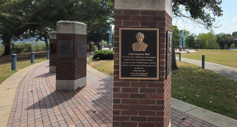
From hosting events in Washington for Mexican diplomats through the Senate Foreign Relations Committee to supporting researchers at McMurdo Station in Antarctica, Celia Heil was the first female of Mexican descent to visit the South Pole. — — Map (db m311523) HM
Spanish conquistador who in the summer of 1559 led a large fleet to the northern Gulf Coast in the earliest grand attempt to colonize the area for Spain. He sailed into Mobile Bay in August 1559 with 11 ships, more than 500 soldiers, 1000 men, . . . — — Map (db m136742) HM
Gregorio Baca bought this house from G. Becker in 1907 for his bride, Chona Ortega. It's walls are 16" thick adobe. The wealthy Bacas & Ortegas ran large herds of cattle & sheep on vast tracts of land in Concho, St. Johns & The R.V. area. — — Map (db m36383) HM
Part of the Spanish migration from northern New Mexico to Round Valley, Faustin Baldonado & his son Pedro bought this adobe home w/1 foot thick walls in the 1890's. Originally a cantina, Pedro added rooms when he married in 1900. — — Map (db m36382) HM
This park contains buildings restored by the White Mtn. Historical Society. They preserve early settler, Hispanic, & Native American cultures, along with farming, forestry and ranching heritage. — — Map (db m36594) HM
The Emerson School bell and concrete nameplate once graced Flagstaff's first permanent education institution, built by the city with a bond generated in an 1893 election. The following year, the Territorial Legislature encouraged school districts . . . — — Map (db m263147) HM
Flagstaff Presbyterian Church
1892 - 1916
Flagstaff Federated Community Church
1916-1927
Mexican Methodist Mission – El Divino Redentor
United Methodist Church 1927-present
The First Presbyterian congregation of Flagstaff was . . . — — Map (db m33364) HM
Text from: Historical Markers with The Arizona Department of Transportation right of way. Prepared by: Roadside Development Section April 1, 1997
Fatigued by a thirty mile ride, the padres picked their way down the rocky north slope . . . — — Map (db m39917) HM
Within sight of this place the Franciscan priests Dominguez and Escalante and their ten companions experienced two of the most difficult challenges among many along the 1,800 miles of their epic journey from the Spanish presidio at Santa Fe, New . . . — — Map (db m40324) HM
This property
has been placed on the
National Register
of Historic Places
By the United States
Department of the Interior
Bullion Plaza
School
1923
— — Map (db m67493) HM
The Old Spanish Trail, the main trade route between Santa Fe and Los Angeles, passed this way beginning in 1829. At the end of the Mexican-American War this portion of the route evolved into what was variously known as the Salt Lake Road, the . . . — — Map (db m78535) HM
In 1863, the United States government created the Arizona Territory from land it acquired during the Mexican-American War and the 1848 Treaty of Guadalupe-Hidalgo. Its northern region remained isolated and undeveloped until the railroad arrived. . . . — — Map (db m209689) HM
Winslow's location as a livestock, trade goods, and lumber shipping point contributed to its growth and stability in the first half of the 20th century. The Santa Fe Railway shipped goods to markets across the country, which in turn made the . . . — — Map (db m209733) HM
This house dating from the 1870s was purchased by Carlos and Beatriz Velasco in 1878. In the same year, Velasco began publication of the newspaper "El Fronterizo," which continued until his death in 1914. This building was the office and . . . — — Map (db m150194) HM
English
In 1981, two young brothers, Orlando and Diego Mendoza, died when a drunk driver ran a stop sign at this intersection hitting the car in which the two children were riding. Orlando was 2 years old; Diego was 17 months. The . . . — — Map (db m83027) HM
This is the only shrine in the United States dedicated to the soul of a sinner buried in unconsecrated ground. It is affectionately called "El Tiradito"- the castaway. The many legends about its origin all involve a tragic triangle love . . . — — Map (db m83030) HM
1914
Room 6 (originally addressed 202 W. 18th Street, and later 709 S. 8th Avenue), on the southeast corner of the excavated row house on Lot 10 (see map), housed several businesses throughout its history. In 1914, it was a blacksmith shop, . . . — — Map (db m57789) HM
Named for its founder, Carmen Soto Vásquez, this was one of the first theaters in Tucson devoted exclusively to the presentation of dramatic works in Spanish. From the opening night, May 20, 1915, with a performance of "Cerebro y . . . — — Map (db m83233) HM
This park is a memorial to the founding of Tucson. On August 20, 1775, Lt. Col. Don Hugo Oconor, Commandant Inspector of the Frontier Provinces of New Spain, in the company of Fr. Francisco Garces and Lt. Juan Carmona officially established the . . . — — Map (db m83011) HM
Memorial to Francisco Garcés, explorer and first Franciscan missionary to the Pima village at the foot of Sentinel Peak. In 1770 Garcés and the Pimas constructed at that site the first substantial building in Tucson, a mission residence with two . . . — — Map (db m83034) HM
[ Four plaques are mounted to a four sided kiosk. ]
Side A:
Jácome’s Department
Stores, Inc.
1896 – 1980
This area was the final location of Jácome’s Department Store from 1951 to 1980. For twenty-nine years the . . . — — Map (db m40049) HM
Named during Arizona’s Territorial period to honor Estevan Ochoa (b.1831 – d.1888), whose ancestors arrived in Mexico with the Cortez expedition. He was born in Chihuahua, Mexico to a wealthy mining and ranching family. Before settling . . . — — Map (db m70211) HM
One of the few remaining sites which recall the Mexican heritage of Tucson, it acquired its name after the Gadsden Purchase (1854) as the terminus of the wagon road joining Tucson to the territorial capital, then at Mesilla. When San . . . — — Map (db m83208) HM
The largest plaza within the Spanish presidio of San Agustin del Tucson, founded in 1775, this area was originally used for military formations and drill. After construction of the first Pima County courthouse (1870), the name was changed to Court . . . — — Map (db m83209) HM
Near this site was the southwest corner of the adobe wall that surrounded the Spanish Presidio, an enclosure of 11 ¼ acres which included most of the present city – county governmental complex and the Art Museum block. Tucson was the largest . . . — — Map (db m83214) HM
The earliest documents for this property indicate that the pioneering Sosa family lived here in the 1850s. In 1878, Manuela Sosa and her husband, Michael McKenna, sold the property to Jesús Suárez de Carrillo, wife of businessman Leopoldo Carrillo, . . . — — Map (db m83228) HM
This adobe house incorporates portions of one of the oldest standing structures in Tucson. The two west rooms are believed to have been built before the Gadsden Purchase of 1854. Four front rooms were added in 1879.
The house was named for . . . — — Map (db m83202) HM
This house is named for its first known residents, living here in 1868. Although construction dates are not known, the Washington Street wing lies along the course of the Presidio wall, completed in 1783. Leonardo Romero, a carpenter whose shop . . . — — Map (db m83203) HM
Once an open space, this area was within the original Spanish presidio. The plaza was probably named in the Mexican years (1821-1854), when soldiers drilled here. Saddle horses for the troops were stabled along the north side, next to the presidio . . . — — Map (db m83210) HM
This marker locates the northwest corner of the adobe wall which surrounded the Royal Spanish Presidio San Agustín del Tucson. In 1776 the new outpost was garrisoned by seventy Spanish cavalry troopers and Indian scouts, transferred from . . . — — Map (db m83212) HM
A tiny chapel, built here in 1915, served the Barriada del Rillito, a community now called El Fuerte. The fifteen immigrant Mexican families of this village gathered outside under mesquite trees to hear Mass. In 1917, Señora Josefa de Mule donated . . . — — Map (db m83018) HM
This Sonoran-styled adobe house was built by rancher Andronico Loroña in 1886 and it is typical of the houses built in early Florence by ranchers. The original flat roof was replaced with a pitched roof covered with tin. Loroña lived here with . . . — — Map (db m68358) HM
Built for Pablo and Elena Llescas in the early 1860s, this single-story row house has two exterior walls not parallel with respect to the other walls. This indicates construction prior to the 1866 Ruggles Street Grid. This building is constructed on . . . — — Map (db m26795) HM
Ignacio Manjarres was a rancher in Florence as early as 1898 when a brand was registered in his name with the county. He was a charter member of the Pinal County Cattle Growers Association. At various times he raised sheep and pigs, fruit trees and . . . — — Map (db m68360) HM
Jesus Martinez, a farmer from New Mexico, began construction on this adobe house in 1872. Completed in 1880, the U-shaped building had a traditional Sonoran flat dirt roof and central patio enclosed on three sides. By 1890 the house was divided . . . — — Map (db m26683) HM
In 1880, Juan Luna built this single-story, Sonoran-style adobe house for his wife and put the title in her name. According to Spanish tradition, it was the polite thing to do. The building's two L-shaped wings are one-room deep, and the original . . . — — Map (db m26791) HM
Manuel Robles made the adobes and built this house in 1881. The single-story residence is an excellent example of a modified Sonoran-style rowhouse. Originally it was an L-shaped structure with a flat earth-filled roof, then about 1913 a flat metal . . . — — Map (db m30403) HM
Immigrant Mexican miners working for the Ray Consolidated Copper Company named the town of Sonora, built near here in 1911. It boomed as a thriving, dynamic community, rich in Mexican culture, language and traditions. In the mid-1950's, the company . . . — — Map (db m250606) HM
Juan Bautista de Anza
National Historic Trail
While the American Revolution brewed on the Atlantic Coast, Spain expanded its New World empire to protect California against the British and Russians. In 1774, Juan Bautista de Anza, commander . . . — — Map (db m82941) HM
The Montezuma Hotel, sixty feet east of here, built in 1886, rebuilt twice, and closed in 1965, was the center of Nogales business and social life for more than half a century. The Office of owner George Christ, First U.S. Customs Collector of the . . . — — Map (db m27082) HM
Pioneer Producer of Silver and Lead, was worked by native labor under the direction of the Jesuits, later by Mexicans before The Gadsden Purchase. Was acquired by Sylvester Mowry in 1856. Provided some lead for the Confederacy. Nearby Ghost town and . . . — — Map (db m24257) HM
This was the northern boundary of Baca Float Number 3, one of five 100,000-acre grants made to the Baca family, in exchange for land taken from them in New Mexico. An attempt was made to relocate this grant to include mines in the Santa Rita . . . — — Map (db m27152) HM
Eager to expand it's New World empire, Spain authorized a 1775-1776 expedition to settle the port of San Francisco. The expedition, lead by Juan Bautista de Anza, commander of the Royal Presidio of Tubac, traversed 1000 miles on foot, horseback, . . . — — Map (db m191836) HM
When the Civilian Conservation Corps worked at Petit Jean in the 1930s, Dionicio Rodríguez, a
Mexican-born artist, sculpted this small bridge above a goldfish pond in a flower garden. He also sculpted a flower basket that is in rubble on the . . . — — Map (db m233676) HM
In this area in 1541 a Spanish expedition from Florida commanded by Hernando De Soto encountered fierce resistance from the Indians, whom they described as the best fighting men they had met. De Soto then turned to the southeast and descended the . . . — — Map (db m201572) HM
In the late 18th century, the Spanish crown sent settlers north from Mexico to colonize "Alta California", where the native people had been living for millennia. The crown rewarded some of these Spanish settlers with large land grants. One of the . . . — — Map (db m238901) HM
This land has attracted people's interest for millennia. A network of ancient trade routes once linked indigenous people of these different regions: the Ohlone tribe of the San Francisco Bay Area, the Bay Miwoks of the Delta and Mt. Diablo, and . . . — — Map (db m197612) HM
The legend of Joaquin Murrieta is one of the most enduring and fascinating of chapters in California history. Facts, fiction and romantic tales entangle to create a legend of unique aura that had become part of California's folklore, especially in . . . — — Map (db m130947) HM
The first known inhabitants of Fruitvale were the Ohlone. In 1820 the Spanish crown gave this land to Luis Peralta, making Peralta Hacienda the first non-native settlement in Oakland.
From 1820 to 1897, the family had a rancho at this site. . . . — — Map (db m28960) HM
This building, erected in 1844-46 by Francisco Solano Alviso, was the first adobe house to be built in the Pleasanton Valley. It was originally called Alisal - The Sycamores. Following the Battle of Sunol Canyon, General John C. Frémont withdrew to . . . — — Map (db m3558) HM
Lt. Colonel Juan Bautista de Anza by decree of Carlos III of Spain led an expedition to this site – The mission being to colonize the San Francisco Bay Area.
In the center of the marker is a circular motif, designed by Doris Birkland . . . — — Map (db m26459) HM
Three descendants of land grant recipient Luís Maria Peralta lived in this home. In 1926, Herminia Peralta Dargie (pictured above) remodeled the home in the style of a Spanish villa. Tiles depict the story of Don Quixote, and adobe bricks saved from . . . — — Map (db m26398) HM
Site of the last home of José Joaquin Estudillo, grantee of Rancho San Leandro and his wife, Juana Martínez de Estudillo. It was built about 1850. The family founded San Leandro, built a hotel, and donated several lots, including the original site . . . — — Map (db m100549) HM
Quincy, located approximately 1 1/2 miles east of here off Mule Creek, was one of the cities within the boundaries of Rancho Arroyo, or the grant, that suddenly appeared in the early 1850's.
Don Andreas Pico purchased the grant from Teodosio . . . — — Map (db m94747) HM
Calaveritas, settled in 1849 by Mexicans, was a flourishing mining town complete with stores, saloons, gambling houses, and fandango halls. Joaquin Murieta is reported to have frequently visited its Fandango Halls and gambling houses. Destroyed by . . . — — Map (db m12992) HM
Born in Mexico in 1832 the renowned "Robin Hood of the El Dorado" spent his early days in Californa working in Contra Costa County as a vaquero before turning bandit.
Dedicated By
Joaquin Murrieta Chapter No. 13
E Clampus Vitus
November . . . — — Map (db m24567) HM
Don Salvio Pacheco was born on July 15, 1793 in Monterey, Alta California. After serving in the Monterey Militia for many years, he petitioned the Territorial Deputation Council of the Mexican government for a Land Grant in 1834. With the possession . . . — — Map (db m206217) HM
Lt. Colonel Juan Bautista De Anza by decree of Carlos III of Spain led an expedition near this site - the mission being to colonize the San Francisco Bay Area — — Map (db m155569) HM
{pictured above on the marker (left to right), Don Fernando Pacheco, 1818-1884; Don Salvio Pacheco, 1793-1876; Don Francisco Galindo, 1820-1891}
In 1868 Don Salvio Pacheco; his son, Don Fernando Pacheco; and his son-in-law, Don Francisco . . . — — Map (db m17440) HM
Dedicated to the family of Don Ignacio Martinez, who settled El Rancho Pinole in 1830. Many of his descendants rest here, members of one of Contra Costa's first families. — — Map (db m53061) HM
Vicente Martínez was born in Santa Barbara on August 18, 1818, the second son of Don Ygnacio and Martina de Arellano Martínez who were married in the Presidio Chapel at Santa Barbara 1802. Don Ygnacio Martínez was a Spanish officer at San Diego and . . . — — Map (db m50827) HM
In 1849, Vicente Martinez built a two-story adobe ranch house on his portion of the Rancho Pinole. This land was inherited from his father, Don Ignacio Martinez, a Spanish officer who became Comandante of the San Francisco Presidio and later Alcade . . . — — Map (db m50821) HM
"...what we see and have before us is
not a river, but much water in a pond."
In the spring of 1776, Lt. Colonel Jaan Bautista de Anza,
Father Pedro Font, and a small group spent four days
exploring the East Bay. They wished to . . . — — Map (db m190712) HM
The 1775-76 expedition of Juan Bautista de Anza
made this site their one hundred first camp from
Horcasitas, Sonora, Mexico. Anza brought 198
colonists, located for Spain the Presidio of San
Francisco and Mission Dolores, and explored . . . — — Map (db m190721) HM
The Juan Bautista de Anza Expedition of 1775-1776 traveled with
240 settlers, soldiers, and others 1,800 miles from Sonora, Mexico
to Monterey, California. Anza then traveled with a much smaller
group to San Francisco and the East Bay to discover . . . — — Map (db m190230) HM
Jose Joaquin Moraga - member of the Juan Bautista de Anza
1776 expedition, founder and first Commandante of the
Presidio of San Francisco - was the grandfather of
Don Joaquin Moraga who with his cousin Don Juan Bernal was awarded this grant in . . . — — Map (db m158344) HM
Lt. Colonel Juan Bautista de Anza by Decree of Carlo III of Spain led an expedition near this site — the mission being to colonize the San Francisco Bay Area
In the center of the marker is a circular motif, designed by Doris Birkland . . . — — Map (db m24728) HM
Headquarters of notorious bandit Joaquin Murieta. Killed here July 25, 1853 by posse of state rangers led by Captain Harry Love. Terrorized mining camps and stage operations during his career. — — Map (db m151585) HM
Headquarters of notorious bandit, Joaquin Murieta. Killed here July 25, 1853, by posse of State Rangers, led by Captain Harry Love. Terrorized mining camps and stage operations during his career. — — Map (db m229467) HM
During and after World War II, nearly 5,000,000
contracted braceros came to work in agriculture
and on the railroads, the majority in California and
the San Joaquin Valley, under U.S. and Mexican Treaty,
demonstrating their patriotism . . . — — Map (db m41067) HM
In 1774, Spain opened an overland route from Sonora to California but it was closed by Yuma Indians in 1781. In 1822, Mexico attempted to reopen this route. Lt. Romualdo Pacheco and soldiers built an adobe fort at this site in 1825-26, the only . . . — — Map (db m50589) HM
Juan Bautista De Anza led two groups of Spanish explorers and settlers across this portion of the Colorado Desert from Northern Mexico to San Francisco Bay. During each tortuous passage, the Spanish camped below here in Yuha Wash. The passage in . . . — — Map (db m50683) HM
Padre Garcés, first recorded non-Indian to visit this locality, came in April of 1776, seeking a new route from Mexico to California. His epic journey covered more than two thousand miles of uncharted wilderness, opening trails that later became . . . — — Map (db m11932) HM
The Forty Acres has been designated a
National Historic Landmark.
This property possesses national significance
in commemorating the history of the
United States of America.
Forty Acres embodies and conveys multiple layers of national . . . — — Map (db m54836) HM
This unpretentious building was the home of Cesar Chavez and his wife Helen. When the Chavez family moved here in 1971, the oldest of their eight children had already moved out of the family home but their younger children were raised here. Cesar . . . — — Map (db m234147) HM
Cesar Chavez, the farmworker who became this
nation's most important Latino leader in the
20th century, chose this as his home, office, and
final resting place. Here he found spiritual and
physical refuge from the conflict and threats
faced by . . . — — Map (db m140336) HM
After Cesar began organizing farmworkers in 1962, Helen looked after their eight children. Over the years, Helen also became a surrogate mother to countless volunteers who journeyed to Delano, and eventually to La Paz, to work for social justice. . . . — — Map (db m234148) HM
The first settlement in the southern San Joaquin Valley, inhabited by Mexicans, Spaniards and Native Americans, existed here between the late 1700s and 1895. At its height, there were 25 to 30 adobe homes, two general stores, a school, a church, . . . — — Map (db m258475) HM
In 1772, Don Pedro Fages, first recorded non-Indian to visit the southern San Joaquin Valley, crossed this spot on his way from San Diego to San Luis Obispo. Near this point crossed Father José María de Zalvidea in 1806, while accompanying the . . . — — Map (db m54266) HM
To quote the authors, Frank F. Latta, Arnold R. Rojas, and Bonnie Ketterl Kane, per Rancho El Tejon’s Mayordomo (Supervisor) of almost sixty years, Don Jose Jesus Lopez (J.J.), about Avelino Martinez; “He was a little dried up gnome of a man, so . . . — — Map (db m98873) HM
Avelino Martinez was of Mexican, Indian and Chinese descent, four feet-four inches tall and thirteen years of age when he came with a group of drovers to the United States from Sonora, Mexico, searching for his father. He worked as a groom for . . . — — Map (db m52918) HM
Rancher John Morrison and his family occupied this historic house in 1904. They lived and worked here for almost 60 years. Morrison‘s family cleared land to grow hay and raised horses and cattle to sell at nearby markets. They also built barns, . . . — — Map (db m167302) HM
Daughters of the American Revolution commemorate the significant role the
Reyes Adobe historical site played in the development of California and its
history. The property was a stop along the state's famous El Camino Real. — — Map (db m154344) HM
While archaeological evidence puts human inhabitance here
back at least 4,500 years, it is believed that the first European
contact in this area may have only occurred in 1772. In less
than three centuries, drastic changes to the land and . . . — — Map (db m262556) HM
The mid-1800s saw Vasquez Rocks quiet, emptied of its Tataviam inhabitants. California underwent
drastic changes under Spanish, Mexican, and American rule. The Gold Rush brought an influx of
settlers, increasing racial hostility and . . . — — Map (db m262562) HM
Contained within this building are the remaining portions of an adobe house built by Francisco Salvador Lugo and his son Antonio María Lugo. Francisco Lugo was a prominent early landholder and Antonio served as the Alcalde of Los Angeles. They . . . — — Map (db m125567) HM
El Barrio Park is built in Claremont's historic Arbol Verde neighborhood, where Claremont's first Mexican American families settled from 1907-1927. The
families of Arbol Verde neighborhood contributed to the development of the town by providing the . . . — — Map (db m287930) HM
Domínguez Ranch House
Central portion built in 1826 by Manuel Domínguez.
Rancho San Pedro
Ten square leagues granted, provisionally by Governor Fages to Juan José Domínguez in 1784. Regranted by Governor Sola to Cristóbal . . . — — Map (db m64857) HM
The Lugos, a Spanish landgrant family, arrived in the pueblo de Nuestra Señora la Reina de Los Angeles in the 1700's and settled prior to 1900 on this site. This was originally a portion of Rancho La Ballona which was established by the Machados. . . . — — Map (db m51869) HM
Born at Mission San Juan Capistrano, Andres Avelino Duarte joined the Mexican Army in 1821. Transferred to
Mission San Gabriel, he was assigned to protect Mission property. Upon retirement, he was granted nearly 7,000 acres,
which included . . . — — Map (db m218626) HM
When the Colonials of the American eastern seaboard were struggling to create and defend man’s most noble achievement in self government, the vast Pacific Southwest was a slumbering frontier. Barely six years before Paul Revere made his famous . . . — — Map (db m135165) HM
The General Andres Pico Oak Tree once stood in Rancho San Rafael in an area that later became part of the City of Glendale. This tree played a significant role in the history of California. On January 11, 1847, representatives of Los Estados Unidos . . . — — Map (db m128302) HM
The Oak of Peace played an important role in the history of California.
It was at this site on January 11, 1847, that the surrender of the
Californios to the United States Army was arranged. Jésus Pico,
emissary of U.S. Lt. Colonel John C. . . . — — Map (db m234878) HM
Leo Lomeli, the local Santa
Fe railway station agent
1942-1960, began building this
home in 1951 for his wife,
Esperanza, and three sons.
It was a labor of love,
completed in 1957 with help
from friends and family.
Lomeli was the first . . . — — Map (db m190945) HM
Honoring the Indians of Puvungna
who fished these shores long before the reign of the Dons.
U.S.A. Bicentennial year 1975
Susan B. Anthony Chapter NSDAR — — Map (db m132708) HM
[Upper Marker - as seen in 2001] This monument marks the intersection of three original California Ranchos:
Rancho Los Alamitos
Rancho Los Cerritos
Rancho Los Coyotes
[Lower Marker - as seen in 2002]
Ranchos
Los Alamitos . . . — — Map (db m50231) HM
The 27,000-acre Rancho was once part of an 18th-century Spanish land grant to soldier Manuel Nieto. The Monterey-style adobe was constructed in 1844 and served the Temple and Bixby families as headquarters for large-scale cattle and sheep . . . — — Map (db m50988) HM
1593 entries matched your criteria. The first 100 are listed above. Next 100 ⊳