It’s August 13, 1539…
Hernando de Soto and his scouting party are passing through the Indian villages of Utinamocharra located just south of here –
My army of more than 700 men follow behind. We will march quickly through . . . — — Map (db m126581) HM
The Spanish explorers brought cattle and horses to Florida when they visited in the 1500s. When the Spanish left, the cattle and horses stayed. Today's cracker cattle and horses are direct descendants of those animals. They are a link to all of the . . . — — Map (db m126399) HM
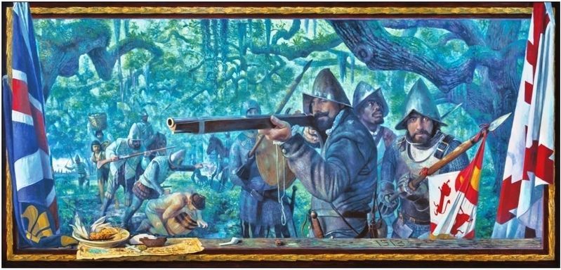
It’s August 15, 1539…
Hernando de Soto and his scouts arrive at the Indian village of Cholupaha. It lies along the present-day Santa Fe River, which runs through here –
My Men captured several Indians and questioned them . . . — — Map (db m126582) HM
The great Quaker naturalist of Philadelphia made a long journey through the southeastern states in the 1770's collecting botanical specimens. In May, 1774, he visited the Seminole Chief, Cowkeeper, at the Indian village of Cuscowilla located near . . . — — Map (db m146839) HM
Blue Sink
Visited by William Bartram, America's first naturalist, in 1774.
Erected by Newberry Garden Club in cooperation with Dist. V. FFGC National Council of State Garden Clubs, Inc.
Fla. Dept. of Transportation — — Map (db m119044) HM
The earliest evidence of human habitation on Cape Canaveral dates back about 6,000 years. Descendants of these first humans, the Ais, inhabited Cape Canaveral along with the nearby islands and the mainland.
There are 95 recorded sites within the . . . — — Map (db m217573) HM
This marker commemorates the men and women who achieved American independence. These Patriots, believing in the noble cause of liberty, fought valiantly to found a new nation.
1775 – 1783
Presented by Brevard Space Coast Regents . . . — — Map (db m217722) HM WM
The Ais were one of the most influential and powerful tribes in Florida when Spanish Army Lt. Alvaro Mexia mapped Ulumay Lagoon in 1605. He wrote in his diary “Here is the town of Ulumay, the first one of the province of Ais. In back of and . . . — — Map (db m72602) HM
Native Americans, explorers and settlers hauled or carried canoes and small boats over this narrow strip of land between Mosquito Lagoon and the Indian River. Eventually it became known as the “haulover.” Connecting both bodies of water . . . — — Map (db m108012) HM
William Bartram, while residing in Florida in 1776-77, explored Mosquito Lagoon by canoe seeing 11 bears in one day and many deer. — — Map (db m164644) HM
William Bartram exploring here in the 1760s collected many new plants and discovered the tropical Zebra Butterfly: Heliconius Charitonius. — — Map (db m164647) HM
Coming over from the Bahamas sometime before 1792, Suries and Frankee Lewis and their three sons settled on the banks of the New River and were the first permanent settlers of European descent in what is now Broward County. In 1793, after reports . . . — — Map (db m63656) HM
It’s July 24, 1539…
Hernando de Soto’s army has set up camp at a nearby Indian village, Tocaste -
I moved ahead with a small scouting party. Just north of the village, we discovered a broad road, which I believe may be the entrance . . . — — Map (db m126576) HM
It’s July 26, 1539…
An advance guard of Hernando de Soto’s army has moved through a nearby area and crossed the present-day Withlacoochee River -
It took us two days to cross the river. The rest of our army soon followed. Weighed . . . — — Map (db m126578) HM
Prior to the Spanish arrival in the 1500s, there were hundreds of thousands of Native Americans living in Florida. Evidence of their diverse culture has been discovered in the mounds, earthworks, middens and other archaeological sites found . . . — — Map (db m132271) HM
It’s July 25, 1539…
Captain Moscoso is leading Hernando de Soto’s army north, from the village of Tocaste, to support De Soto’s scouting party…
Passing near a large lake, we were met by messengers sent by De Soto. They told us the . . . — — Map (db m126577) HM
Seminole Migration Story of Survival The Seminole are descendants of the Muscogee group consisting primarily of Creek Indians from Georgia and Alabama. In the early 1700s, various bands of Creeks and other Muskogean peoples began to migrate . . . — — Map (db m132273) HM
Pupo is first mentioned in 1716 as the place where the trail from the Franciscan Indian missions and the Apalachee (present-day Tallahassee) to St. Augustine crossed the river. The Spanish Government built the fort on the St. Johns River some time . . . — — Map (db m62187) HM
Orange Park was the site of a cotton and citrus British plantation, Laurel Grove, which was established by William and Rebecca Pengree during Florida’s British Period (1763-1783). Following the American Revolution, Florida was returned to . . . — — Map (db m102603) HM
Fort Mose (pronounced “Moh-Say") was a plastered earthen fort located approximately 3 miles north of St. Augustine. It was established to protect the small, free-black settlement of Gracia Real Santa Teresa de Mose.
When the British . . . — — Map (db m178728) HM
The first muster of militia troops in the continental United States took place on 16 September 1565 in the newly established Spanish presidio of St. Augustine. Both free and slave Africans served with the original occupation and settlement force . . . — — Map (db m178740) HM
Global War On Terrorism
This Memorial Honors The Citizen Soldiers Of The Florida National Guard Who Paid The Ultimate Sacrifice For Their Nation In Support Of The Global War On Terrorism.
Minutemen
Symbol Of The Citizen . . . — — Map (db m178104) WM
It’s August 17, 1539…
When Hernando de Soto’s scouts sight the abandoned Indian village of Caliquen, Cavalry Captain Baltasar de Gallegos is ordered to move ahead –
My men and I were sent to check for food and supplies. When . . . — — Map (db m127006) HM
It’s September 10, 1539…
Conquistador Hernando de Soto has come to Uriutina, a deserted Indian village near here.
We have feasted upon the bounty of food left behind by the fleeing villagers. Messengers sent by Chief Uzachile have . . . — — Map (db m126584) HM
In 1769 during the English occupation of Florida English investors established Newcastle Plantation. The plantation was first managed by David Courvoisie, but in 1771 was placed under the charge of Francis Philip Fatio, a native of Switzerland. . . . — — Map (db m238260) HM
500 Spanish soldiers from St. Augustine marched four days through marsh, forest tangle, fierce wind, and heavy rainfall to an encampment near here. Exhausted and hungry they rested in a downpour; at dawn they attacked and captured France's Fort . . . — — Map (db m46579) HM
Historic references to the plantation house on Fort George Island are tantalizingly brief. The first detailed descriptions of the house and structural changes were recorded in the 20th century. From this vantage point, you can see the changes that . . . — — Map (db m40536) HM
The plantation era began in Florida in 1763 after Britain took control from Spain. Soon after, the first planter was given land here and brought his slaves and household.
Britain established a plantation economy and encouraged its growth by . . . — — Map (db m145387) HM
Jean Ribaut and a party of Huguenots landed the morning of May 1, 1562 on this island. Here they knelt in prayer, beseeching God's guidance and commending the natives to his care. This was the first Protestant prayer in North America. — — Map (db m40024) HM
English:
Once the Portuguese made successful transatlantic trading voyages, other European nations quickly followed. In the eighteenth century, the port of Nantes became the busiest French port involved in the European slave trade . . . — — Map (db m145391) HM
English:
Slavery has been a component of human history through time. Whether captured, purchased, or taken as spoils of war, enslaved people had wide-ranging experiences, but they all shared one thing in common: loss of freedom. . . . — — Map (db m145392) HM
Side 1
Sawpit Bluff Plantation, located on Black Hammock Island, was built in the 1750s by Edmund Gray. The plantation was named for the sawpit excavated to accommodate the up and down motion of a vertical saw blade. The plantation house . . . — — Map (db m92973) HM
In 1562, when France was being torn by religious strife, Gaspard de Coligny, Admiral of France, sent two vessels to the New World in search of a refuge for the oppressed Huguenots. Leading the expedition was the Huguenot explorer, Jean Ribaut, who . . . — — Map (db m33486) HM
Fifteen hundred thirty feet
north of this spot stood an
early Spanish fortification
- Fort San Nicholas -
Abandoned July 4, 1817
This marker erected by Jacksonville Chapter D.A.R. — — Map (db m220558) HM
"[The Spaniards] made a horrible, tragic slaughter of our forces, so great was the anger and hatred they had for our nation. They vied with one another to see who could best cut the throats of our people..." 1565 la Caroline carpenter . . . — — Map (db m46573) HM
"After... two months... Ribault made port in New France... [where] he discovered a very large and beautiful river ... Ribault erected a column of hard stone on the banks of this river ... The coat of arms of France was carved upon it." René . . . — — Map (db m46575) HM
(Front): This is a replica of the marker placed on or near this spot by Jean Ribaut May First 1562 in taking possession of Florida for France. (Back): Erected by the Florida Daughters of the American Revolution May First 1924 . . . — — Map (db m46578) HM
During the sixteenth century, France was determined to expand its empire. Spain, the world's leading power, already had a foothold in the Americas, and France wanted to share of the riches the Spanish were gaining through trade and plunder. France's . . . — — Map (db m46574) HM
"Every one of us - noblemen, soldiers, workmen, sailors - worked hard to get our post ready to shelter us from the weather and protect us against enemies." Jacques le Moyne, 1564 la Caroline colonist and artist Measuring a piece of . . . — — Map (db m46572) HM
"[H]aving landed [on the River of May's shore]... we saw the chief of that country, ... he ... showed such enthusiasm that he almost lost his composure. He came up to us... repeating ...'friend, friend.'" Captain René de Laundonnière, 1564 . . . — — Map (db m46555) HM
"[The Timucuans] brought us grains of roasted maize,... smoked lizards or other wild animals... and various kinds of roots, some for foods, others for medicine. And when they discovered that we were more interested in metals and minerals, they . . . — — Map (db m46571) HM
Bound by the Nassau River, the Atlantic Ocean, and the St. Johns River, the Timucuan Ecological and Historic Preserve seeks to protect much of the water and undeveloped land you see from here. Salt marsh, coastal hammock, tidal creeks, and sea and . . . — — Map (db m46576) HM
At this spot the Kings Road met the Apalache Trail, so connecting the English colonies and the Spanish settlements of the west with St. Augustine and New Smyrna — — Map (db m138343) HM
This narrow part of the St. Johns River, near a clear freshwater spring was a crossing point for Indians and early travelers. The Indian name Wacca Pilatka, meaning "Cow's Crossing", was shortened by the English to Cow Ford, and Jacksonville was . . . — — Map (db m58715) HM
General John McIntosh (c.) 1756-1826 was born in Darien Georgia. He assisted botanist William Bartram 1773-1774, and in 1774 they explored along the St. Johns River. His activities during the Revolutionary War included serving as a captain, . . . — — Map (db m138114) HM
Though several European nations controlled Pensacola in its 460-year history, Spain reigned the longest. Spain made Pensacola the capital city of West Florida, turning the small, rural town into a thriving municipal center. Two hundred years ago, . . . — — Map (db m183441) HM
Raising the United States flag over Pensacola
ended Spain's control of Florida. Through time,
many buildings rose and fell over the colonial
remains of Pensacola's past. By the time Florida
became a state in 1845, Pensacola's harbor was
vital. . . . — — Map (db m183481) HM
Archaeology, the study of past peoples and
cultures, can reveal clues that often are not
recorded in historical documents. For example,
although documents and maps showed that
the British Commanding Officer's Compound
was located here, those . . . — — Map (db m183468) HM
In 1825, George Barkley purchased Lot 31 and
within 10 years acquired several surrounding
lots. The construction date of the Barkley
House is unknown, but is likely to be around
1835. This structure is the oldest masonry
building in . . . — — Map (db m177110) HM
On March 9, 1781, Spanish General Bernardo de Galvez, with a fleet of some 30 ships, arrived opposite Pensacola Bay and within a day took Santa Rosa Island. On March 18, Galvez, in his ship Galveztown, sailed under the cannon of the Royal Navy . . . — — Map (db m72252) HM
British Governor Peter Chester commissioned a
three-story mansion on this site to avoid using the
rundown Spanish governor's house. Governor Chester
was never satisfied with the design and overspent
his budget many times. The result? He lived in . . . — — Map (db m183529) HM
In 1763, a treaty transferred Spanish Florida to the British and Pensacola
became the capital of West Florida. The civilian government arrived in
1764 and set up a town grid with streets, house lots, and garden lots
surrounding the centrally . . . — — Map (db m183479) HM
This area was a garden district in the First
Spanish and British governors' compound.
The well first shows up on maps of the
fort in 1778 and provided drinking water
and irrigation for the gardens. The shaft
is lined with stones and timbers at . . . — — Map (db m183489) HM
Here, the Commanding Officer and his guests dined on exotic
local fare using fine imported porcelain. The British built
wood-burning brick ovens in an outdoor cooking area. Near
these ovens, archaeologists found food remains including
alligator . . . — — Map (db m183469) HM
From 1754 until 1821, a succession of Spanish and British forts were constructed in this area of Pensacola. You are standing at the west end of the forts. They extended nearly 200 yards eastward. The Spanish, then the British, and again the . . . — — Map (db m80168) HM
Explore the many layers of West Florida's history!
Welcome to the Colonial Archaeological
Trail! This Trail consists of outdoor exhibits
around historic downtown Pensacola.
Much like today, the Pensacola of 200
years ago was home to . . . — — Map (db m183531) HM
A native of Spain, Don Manuel Gonzalez joined the army at Madrid and was sent to New Orleans. After his discharge he was granted passage through the Choctaw and Creek Nations to Pensacola. At Pensacola, he was a successful cattle rancher. He opened . . . — — Map (db m80051) HM
Born Dorothy Camber, to a British plantation owner at South Carolina, Dorothy married lawyer George Walton at Savannah shortly before the beginning of the American Revolution. George Walton attended the Continental Congress in Philadelphia signing . . . — — Map (db m80043) HM
Spanish colonists officially moved to what is now downtown Pensacola in
1756 after a series of hurricanes destroyed their settlement on Santa Rosa
Island. The population was small but diverse, including people of European
and African heritage . . . — — Map (db m183471) HM
Fort George, named in honor of King George III of
Great Britain, is set in the North Hill Historic District of
Pensacola. The hilltop landform was once referred to
as Gage Hill. A British officer suggested this strategic
location as a possible . . . — — Map (db m183494) HM
Site of Fort San Bernardo. Built by Don Bernardo de Galvez, Governor of Spanish Louisiana. From this Fort the Spanish bombarded the English-held Fort George; April 27, 1781 and Fort George surrendered May 9, 1781. 15,000 soldiers occupied Fort San . . . — — Map (db m72272) HM
Old Punta del Gorda, skirted by Spanish ships of Maldonado 1540, de Luna 1559, Pez 1693, Ariola 1698. Spanish mission to Yamassee Indians nearby 1750. In British grant to Wm. Aird and Benj. Wormell in 1760s; Spanish grants to Francis Gabarron . . . — — Map (db m146487) HM
So~named because under British, each purchaser of lots in the Old City (South of here) was given a plot with the corresponding number (North of here) on Conway Street for garden purposes. Lots were 80' x 278'. Section included present Garden Street . . . — — Map (db m72269) HM
These bricks are part of the foundation for the
garrison kitchen that served military troops and
government officials inside the British Fort of
Pensacola from 1767 to about 1813. The kitchen
had four rooms with separate doorways, two
windows, . . . — — Map (db m183519) HM
received West Florida from Spain
and raised the flag of the U.S.
July 17, 1821
—
To recall the flags of five
nations which have been raised in
turn ten times over Pensacola
Spain 1559-1719+1723-1763+1783-1821
France . . . — — Map (db m80072) HM
A native of Aberdeen, Scotland, John Innerarity was the nephew of Spanish Pensacola's leading merchant William Panton. He arrived in Pensacola in 1802 to become managing clerk of the Panton, Leslie and Co. trading post. However, his uncle had died . . . — — Map (db m80078) HM
Born a nobleman in Spain about 1757, Noriega served his country with distinction in the Louisiana Infantry Regiment against the British at Baton Rouge, Mobile, and Pensacola between 1779 and 1781. His son Jose Noriega, born at Pensacola in 1788, . . . — — Map (db m80047) HM
In the year of Pensacola's 450th anniversary celebration of the Luna expedition, Their Majesties King Juan Carlos I and Queen Sofia of Spain visited the city to commemorate our community's long Spanish heritage. In August 1559, an expedition . . . — — Map (db m52515) HM
The British constructed the Officer's
Room and kitchen inside the western
gate of the Fort of Pensacola in 1775.
This kitchen served troops stationed
in the nearby blockhouse located
along the fort wall. University
of West Florida . . . — — Map (db m183464) HM
Built in 1832 during the American period,
this church served as an Episcopal house
of worship. It later became Pensacola's
first public library and an historical
museum. UWF archaeologists excavated
under the church floor and uncovered
the . . . — — Map (db m183522) HM
At age nine, in 1859, Philip Keys Yonge moved to Pensacola with his family from Marianna, Florida. The Yonge family came to Florida from England during the British Colonial Period. He began a career in the lumber business in 1876 at the Muscogee . . . — — Map (db m80040) HM
As a result of General Bernardo de Gálvez's 1781
attack on Pensacola during the American Revolution,
the British returned West Florida to Spain in 1783.
The Second Spanish occupation shaped much of the
modern city's design including many street . . . — — Map (db m183477) HM
St. Michael's Cemetery is one of the two oldest
cemeteries in Florida. 'The earliest surviving
tombs date to the Second Spanish period,
though the cemetery was in use much earlier.
By the 1760s, a colonial road ran through
this area and the . . . — — Map (db m183496) HM
Born on the island of Trinidad in 1812, Stephen Mallory's family eventually made Key West their home. Mallory studied law, volunteered in the Florida militia during the second Seminole War, and became Inspector of Customs at Key West. In 1830 . . . — — Map (db m80042) HM
During the British period in 1767, this area became the Commanding Officer's Garden. Colonists established garden plots in an attempt to make the colony self-supporting. Houses in the fort district maintained corresponding garden lots, located north . . . — — Map (db m183465) HM
This excavated area includes a part of the space where the Commanding Officer's Compound was located. It included a building, outbuildings, a formal garden area, and an outdoor kitchen. In addition, it was the center of Fort business, especially . . . — — Map (db m80170) HM
This flag pole is located in the same general location as the pole that was used to raise the American flag over Florida officially for the first time. After signing the agreements in a building located near the dig site, soldiers of both the . . . — — Map (db m80165) HM
The exhibit to your left shows part
of a trench excavated by UWF
archaeologists. This trench extended
into Plaza Ferdinand VII and revealed
the remains of two British forts. The first,
built in 1767, was called the Star Fort
and its palisade . . . — — Map (db m183460) HM
Archaeologists discovered several wells in the courtyard of
Don Luís Joseph de Ullate's compound. This well, originally
made from wooden barrels stacked on top of each other
with their bottoms knocked out, supplied fresh water to the
Spanish. . . . — — Map (db m183484) HM
Bartram wrote of the security and extent of intracoastal water ways from Virginia's Chesapeake Bay to the Mississippi, in 1774. — — Map (db m110475) HM
Starting in the mid-1500s, the Pensacola area became a pawn in a European power struggle in the New World. Adventurers from Spain, France and Britain competed with each other to establish a foothold on the Gulf of Mexico. Spain established several . . . — — Map (db m80079) HM
Feel the grooves inside this rare cannon barrel. This Rodman cannon was cast in 1861 as a 10-inch smoothbore, which fired round cannonballs. To keep up with modern technology, the U.S. Army in 1884 inserted an 8-inch rifled sleeve into the old . . . — — Map (db m80080) HM
Getting sugar out of the sugar cane was very hard work. Not only did slaves have to cut the cane exactly when it was mature, they had to crush it and boil the juice as soon as possible in order to get the most and best sugar out of the crop. . . . — — Map (db m234836) HM
What’s That Rock on the Beach?
What is that rock growing out of the beach sand? This is Coquina (ko-key-nah), Spanish for “little shell.” Coquina rock is a mixture of shells and quartz sand. It was formed by nature hundreds . . . — — Map (db m153622) HM
Plantations lined the banks of tidal waterways and freshwater rivers in northeast Florida by the late 1700s. Planters sought wealth from rice and indigo and later sea island cotton.
Florida’s Spanish government offered free ownership of land . . . — — Map (db m208300) HM
This road was built about 1766 when Colonel James Grant was governor of British East Florida. It extended from St. Augustine to Cow Ford (Jacksonville) and north to Colerain, Ga., across the St. Marys River. Later the road was extended south . . . — — Map (db m72754) HM
In 1791, the King of Spain offered a 1,100-acre land grant to Francisco Pellicer. Henry Mason Cutting purchased the property in 1886, renaming it Cherokee Grove. Featuring local materials including tabby block cladding, cedar and palm tree trunk . . . — — Map (db m101222) HM
During a storm in 1799, the schooner Fox ran aground off the eastern end of St. George Island. On board was William Augustus Bowles, a British citizen and self-styled leader of the Creek-Cherokee nation. Bowles was bringing gunpowder and bullets, he . . . — — Map (db m52650) HM
The 1795 Treaty of San Lorenzo defined the international border dividing Spanish Florida from the newly formed United States.
No one who signed the treaty had ever seen it, but the point of land formed by the confluence of the Chattahoochee and . . . — — Map (db m230733) HM
River Landing Road follows the approximate route of the "Old Spanish Trail" or "Mission Road," a colonial era path that led west across Florida from St. Augustine.
Spanish friars and soldiers used the road to reach a chain of missions or religious . . . — — Map (db m230673) HM
At the end of the American Revolutionary War in 1783, Florida was returned to Spain after twenty years of British control. Controversy soon arose over the exact location of the boundary between Spanish Florida and the state of Georgia. In 1795, . . . — — Map (db m79444) HM
Settlers in the new U.S. territory of Florida (created in 1821) who were members of the Masonic order soon established lodges in their new communities. Washington Lodge No. 2, Free and Accepted Masons, created in 1828 was among the first Florida . . . — — Map (db m79484) HM
(Front): In 1717, on this site, the French began erecting Fort Crèvecoeur within Spanish domain. On February 8, 1718, Jean-Baptiste Lémoyne de Bienville, acting Governor of Louisiana, dispatched his brother, Lémoyne de Châteagué to complete . . . — — Map (db m8164) HM
It’s July 23, 1539…
Conquistador Hernando de Soto and his advance guard of 12 horsemen have just passed the small Indian village of Vicela…
I have decided not to stop here. We must press on further north and reach the chiefdom of . . . — — Map (db m126575) HM
It’s July 20, 1539…
Here at the Indian village called Luca, Calvary Captain Baltasar de Gallegos reports back to Hernando de Soto –
My mission to meet with the great Chief Urriparacoxi was unsuccessful. The chief hid in the . . . — — Map (db m126574) HM
It’s June 20, 1539…
Juan Ortiz, a lost Spaniard from an earlier expedition with Pánfilo de Narváez, is found by De Soto’s men not far from here. He tells his story –
Ten years ago I was captured by Chief Ucita. I later escaped to the . . . — — Map (db m126571) HM
It’s May 30, 1539…
Spanish conquistador Hernando de Soto has arrived here in La Florida, Land of Flowers, and stepped ashore –
My men can now offload our nine ships. We have sailed with 500 tons of materials needed for our . . . — — Map (db m126569) HM
407 entries matched your criteria. The first 100 are listed above. Next 100 ⊳