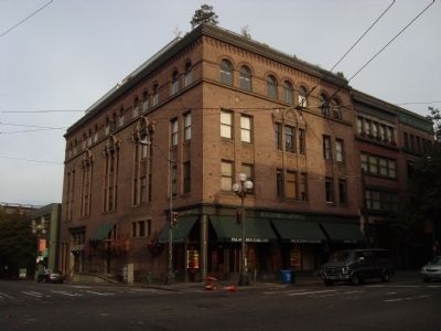
Smith and Squire Buildings, designed by Max Umbrecht and C.H. Webb, were built in 1900, and combined in a later renovation. The Steinberg Clothing Company occupied the original premises, which were redesigned as residential lofts in 1982 by Hewitt . . . — — Map (db m48124) HM
Seattle’s first skyscraper opened on July 4, 1914. The 42 story Smith Tower was the tallest building outside of New York City and Seattle’s tallest for nearly fifty years. It was built by Lyman Smith of Smith-Corona and Smith and Wesson fame, from . . . — — Map (db m22481) HM
To celebrate the 100th anniversary of UPS, employees gathered here at the company’s birthplace to honor, celebrate and reaffirm UPS’s commitment to serving communities around the world. — — Map (db m48165) HM
One ton of gear for a year, purchased from Seattle stores like Cooper & Levy.
When news of the Klondike Gold Rush hit the nation's
newspapers in 1897, about 70,000 stampeders rushed to Seattle to catch ships going north to Canada via Alaska. . . . — — Map (db m157615) HM
A historic day in Seattle
Just after 1pm on July 07, 2014, Deb Green, a 65-year-old marathon running grandmother from Ballard brought her camp chair, a hat, and a book as she planted herself down to become the first person in line to legally . . . — — Map (db m116579) HM
The station was completed in 1906 for James J. Hill and his Great Northern Railroad. The depot and the vast freight yards were built on the reclaimed tide flats adjacent to a newly developing warehouse and industrial district near Pioneer Square. . . . — — Map (db m22490) HM
Under the provisions of the National
Historical Preservation Act of
October 15, 1966, this property
possesses exceptional value in
commemorating or illustrating
American history
Placed on the National Register on
May 12, 1976 by . . . — — Map (db m181414) HM
c. 1906
This property
has been placed on the
National Register
of Historic Places
by the United States
Department of the Interior — — Map (db m181513) HM
In 1890 when James J. Hill decided to extend his Great Northern Railway to the Pacific coast from Montana, he hired John F. Stevens as chief locating engineer to determine the route of the railroad. After locating Marias Pass in Montana, Stevens . . . — — Map (db m129319) HM
Flat-bottomed boats carried passengers and goods on the Duwamish River to and from the Green and Black rivers from 1854 to 1886. Names of the boats were the Minehaha, the Black Diamond, the Decatur, the Comet, and the Gem. A landing for the . . . — — Map (db m181561) HM
Originally built as a dormitory for girls working at the Puget Hotel; it later housed Chinese workers who worked at the Puget Hotel from 1925 until 1936, when they left Port Gamble.
Earliest record of Chinese in Port Gamble was 1870, with 12 men . . . — — Map (db m129349) HM
One of the last structures erected in Port Gamble, this building symbolizes the rise of the automobile which reduced the need for company towns after WWI. Pope and Talbot leased the property to a private operator, ensuring much-needed service . . . — — Map (db m129352) HM
Following the fire of 1914, one of the first buildings rebuilt in cement was
Young's Block, opening in 1915. Here the Olympic Restaurant reopened for
business, and Ronald Young opened a garage and auto livery service which
replaced the hotel's . . . — — Map (db m227841) HM
In 1886, Northern Pacific Railroad mining engineers located large seams of coal and the town of Roslyn was founded.
Coal mining, though dirty and dangerous work, attracted large numbers of immigrants to Roslyn – Serbians, Croatians, Poles, . . . — — Map (db m38422) HM
In 1908 Samuel Hill (1857-1931) bought 7,000 acres on these slopes. He planned a Quaker farming colony, surveyed a 34-block tounsite and built a church, hotel, store, offices, garage and shops. His engineers built ten miles of experimental roads; as . . . — — Map (db m34471) HM
The Columbia River Gorge is a natural passage-way between rural inland farms and western shipping docks.
Transporting crops was difficult for early homesteaders who relied on wagons and steamboats. Water still provides a route, but modern barges, . . . — — Map (db m158631) HM
In 1923, the Great Northern Railway received 28 Class P-2 “Mountains” from the Baldwin Locomotive Works. These locomotives were assigned numbers 2500 through 2527 and had 29 X 28 cylinder, 73” drivers, a 200 psi boiler pressure, a . . . — — Map (db m128995) HM
Since time immemorial, the area surrounding Celilo Falls was the hub of a vast American Indian trade network that stretched from California to Alaska, and from the Missouri Plains to the Pacific Ocean. Native people established this trading center, . . . — — Map (db m128968) HM
William Packwood and James Longmire traveled across Naches Pass during the 1840s exploring for an easier route east. The trail they blazed is known today as Cowlitz Pass. The explorers discovered this area in 1854 and called it Sulphur Springs; the . . . — — Map (db m84453) HM
Harry McCormick and F. B. Hubbard organized the McCormick Lumber Company in 1897. The mill was located two miles west of Pe Ell on the South Bend branch of the Northern Pacific Railway. It consisted of a shingle mill, planing mill, dry kilns, . . . — — Map (db m129138) HM
The Shay-type locomotive is a large steel vehicle whose most prominent features include an engineer’s cap, oil fuel bunker, large boiler and exposed engineer.
This locomotive was built in 1924 and is 41 feet 2 inches long, 16 feet 2 inches high . . . — — Map (db m116839) HM
This beautiful river valley forms a natural north-south passage, used for centuries by Indians. Later came Hudson’s Bay Company fur brigades, packing pelts from Canada to Fort Okanogan. Hardly had the dust settled from the last brigade (1846) when . . . — — Map (db m129000) HM
In 1886, shortly after their arrival, Lee Ives and his wife Rena built two log cabins near the river bank and started taking in travelers. Their cabins were located very near this spot in what was to become Pateros.
Lee Ives built the Ive's . . . — — Map (db m129012) HM
By this time, Pateros had about 850 residents. The main street boasted more than forty businesses that included two grocery stores, Elgin Yeager’s Barber Shop, a hardware store, the Pateros Theater and two lumber yards, Brownson and Wagner. There . . . — — Map (db m128996) HM
Below this sign you can see the remnants of the China Ditch built by Chinese miners sometime between 1860 and 1880. This ditch carried water from a diversion point three miles up the Methow River to sluice gold from the Columbia River sandbars a . . . — — Map (db m128997) HM
In 1965, the entire downtown area of Pateros was destroyed when Wells Dam, located six miles downstream, was being constructed on the Columbia River. The entire downtown business district of Pateros was leveled. Paralleling the Columbia River, . . . — — Map (db m129014) HM
The head of navigation on the Okanogan River during steamboat days until 1914 when the railroad came. The shrill sound of the boat whistle to open the drawbridge, rattle of freight wagons and ringing of freight bells which served the north half of . . . — — Map (db m207934) HM
In 1886 Wellington French immigrated from Quebec Canada to the Okanagan Valley and homesteaded this ranch on Scotch Creek. He married Mary McCaskill on Nov. 11 1889 in Spokane. She bore four children: Eva, Katie, Robert and Ray, all of whom grew up . . . — — Map (db m207932) HM
A Collision of Cultures
First they came by sea and then by land - the Euro-American presence swelled through the region. The newcomers brought strange illnesses, like smallpox and malaria, and unwittingly spread plagues of death to the . . . — — Map (db m177402) HM
The Chinook commanded the mouth of the Columbia and lands up the coast to Willapa Bay in the north and down the coast to Tillamook head in the south going back centuries. They lived at the heart of a vast trade network, and served as middlemen, who . . . — — Map (db m177358) HM
The Search for the Northwest Passage
How did Euro-Americans lay claim to this place? For centuries, explorers sent by European nations with imperial ambitions sought the Northwest Passage — a navigable sea route connecting the Atlantic and . . . — — Map (db m177405) HM
"It is estimated that with two canneries, the lumbering, cranberry and railroad interests centering at Ilwaco annually put into circulation at this town about $600,000. This is a solid town and is entitled to the attention of all visitors to . . . — — Map (db m116580) HM
Only a few high-powered steamboats were able to make it through the rocks and rapids of Box Canyon until the U.S. Army Corps of Engineers completed blasting and clearing rock to widen and deepen the channel. Before 1907, most passengers and freight . . . — — Map (db m197111) HM
Engine Data
478 Horsepower
22 in. cylinder – 42 in. stroke
120 lbs. PSI steam pressure
63,000 lbs. in weight
Wheel Data
16 Ft. in diameter
100 RPM
42 in. face
20,000 lbs. in weight
The . . . — — Map (db m73497) HM
This structure was a close relative to the Carbon Hill Coal Company’s brick store that sat directly across from it on Pershing Avenue. Right around 1880, this building held Carbonado’s first Post Office. It’s known that a barber shop once inhabited . . . — — Map (db m54791) HM
The vacant log along the shore below hides the story of one of the community's most remarkable pioneer women. Theresa Sweeney was born in Ireland and received her college education in England. She came to America in 1893 and settled in Gig . . . — — Map (db m179828) HM
Boat building was one of the first industries on Gig Harbor's waterfront, beginning with the launch of the Vine in 1890 at the Gig Harbor Mill. More than 140 wooden boats were constructed along the waterfront between 1912 and 1931 at three . . . — — Map (db m179922) HM
Austin Mill: Employment to Many in Area
While his wife and children waited in Maltby (Wa), Charles Osgood Austin arrived in Gig Harbor in 1909. He was looking for a good place to build a saw mill.
Austin liked a small, low point of . . . — — Map (db m179865) HM
In the late 1800s and the first decade of the 1900s, this was the corner of a 10-acre park extending from People's Dock to today's Pioneer Way. It had rustic tables, an outdoor dance floor, and a mineral water spring. It was a place for picnics . . . — — Map (db m179998) HM
In 1867, Sam Jerisich, Peter Goldsmith, and John Farrague were fishing in Puget Sound when bad weather prompted them to seek shelter in Gig Harbor. They liked what they saw and decided to make it their home, becoming the first three white people . . . — — Map (db m179977) HM
Anchor Donated by
Marion N. Stancic
In Memory of a Fishing Family:
Nickolas Castelan, Sr. 1874-1921
John (Evo) Stancic 1891-1971
John B. Stancic 1905-1974
John S. Jerkovich, Sr. 1896-1974
George A. Plancich, Sr. 1898-1963 . . . — — Map (db m179982) HM
On nearby docks you can see some of Gig Harbor's fishing fleet.
The salmon-rich waters of Puget Sound made Gig Harbor an ideal home for fisherman. Founded largely by immigrants from Croatia in the late 1800s, this industry became the center . . . — — Map (db m179925) HM
This corner is rich in local history. When the first white men settled in Gig Harbor, they shared the bay with the Native American people who lived in a village on this corner. In the mid 1880s, the Indians permitted the use of one of their . . . — — Map (db m179889) HM
Harry Richard Thurston was born October 10, 1889, in Minnesota. He moved to Gig Harbor in 1919 from Tacoma. Thurston had been an electrical contractor in Minnesota. In Gig Harbor, he sold and serviced portable light plants, set up switchboards, . . . — — Map (db m179992) HM
In memory of the fishermen of Gig Harbor who have gone to sea
at great risk with passion and hard work, this statue is a tribute
to an industry upon whose labor our community was founded.
LOST AT SEA
John Ancich, Jr. • . . . — — Map (db m179979) HM
Called the head of the harbor, North Gig Harbor, or Finholm's Marketplace, this area was the harbor's first downtown. Beginning in the 1880s and into the early 1920s it was home to the community's first mercantile, first library, first phone . . . — — Map (db m179830) HM
Settlers from Albert Lea, Minnesota, established Gig Harbor's first sawmill, the Gig Harbor Lumber Company, near this spot on the waterfront in 1887. The sawmill cut as much as 100,000 board feet of lumber daily. Its 450-foot wharf could . . . — — Map (db m179980) HM
Peninsula Light Company's roots in Gig Harbor date back to 1924, when the community began to discuss how it could form its own electric utility. At the time, Tacoma Power was building a transmission line through the peninsulas to deliver power . . . — — Map (db m179874) HM
The People's Dock was established near here about 1890. At the time, it was one of three docks in the harbor servicing freight and passenger traffic on steamboats. In 1923, the People's Dock became the community's car ferry dock. It served . . . — — Map (db m180041) HM
Andrew and Bertha Skansie purchased this property just after the turn of the century, first building a cabin on the beach. In 1910 they constructed the brick home. Andrew was a young but accomplished stone mason, bringing the skill from Croatia . . . — — Map (db m179984) HM
The head of the bay business district included a post office, livery stable, general store, and real estate office. Around 1907, Swedish Captain Axel Uddenberg built his home and opened a meat market near this site. "Front Street", now . . . — — Map (db m179837) HM
"The Landing" draws from Gig Harbor's rich
maritime history. The name and form refer to the
landing of the captain's gig from the 1841 Wilkes
Expedition. It also recalls the time when rowboats were
a main form of transportation and pays . . . — — Map (db m180043) HM
This building is dedicated to the Sehmel Family,
pioneers of the Gig Harbor Peninsula
[photo of the Sehmel house]
W.L.C. Henry Sehmel homesteaded in the Rosedale area in 1884. In 1887, Henry married Dora Gummert. Dora made her way to . . . — — Map (db m179887) HM
Ester Allstrum was a well respected Tacoma food inspector. National magazines recognized her as "the woman who has made Tacoma famous for its model food ordinance." — — Map (db m168252) HM
Janet Elder Steele built the first hotel in Old Town in 1869 at the corner of 30th and Carr Streets. Operating until 1883, the hotel had 24 rooms and was famous for its good food and cleanliness. — — Map (db m157587) HM
Morton Matthew McCarver General Iowa and Oregon Militias Born in Madison County, Kentucky, January 14, 1807 Died at Tacoma, Washington, April 17, 1875 Pioneer and founder of Burlington, Iowa – 1883 · Linnton, Oregon – 1843 · Tacoma, Washington . . . — — Map (db m221083) HM
The late, great, rich & powerful
Andrew Carnegie:
A real man of steel
Born 1835 in Scotland
came to USA 1848.
Was a bobbin-boy, clerk
telegraph & newspaper guy,
built bridges, made iron,
near monopolized steel.
Wrote books & . . . — — Map (db m74358) HM
Captain Blackwood's Handsome Launch. Plying Between Bellingham and Anacortes. Two Trips Daily. The Handsomest and Most Commodius and Sea Worthy Boat of the Kind on Puget Sound. 1907 — — Map (db m74360) HM
had a market here 1922-57
——————————
Paul Luvera Sr. Memorial Highway
An Italian immigrant who exemplified the fulfillment of the American dream, Paul N. Luvera, Sr.'s life . . . — — Map (db m74088) HM
(above photo) La Conner 1873: The first trading post on the Swinomish flats was established in 1867 upon the present site of the Town of La Conner by Alonzo Low.
Thomas Hayes was the next Swinomish trader of record. He arrived shortly after . . . — — Map (db m177974) HM
From Dick Fallis, Historian, Skagit County Pioneer Association
Jasper Gates was born April 9, 1840, in Adair County, Missouri. He grew to manhood at the family farm there, married Clarinda Kimble in 1860, served in the Union Army during the . . . — — Map (db m75484) HM
The first trains and automobiles chugged through Stevenson in 1908, a few years after Lewis and Christian Aalvik has built these two boilings that share a common roof.
Lewis Aalvik rented the east building to a hardware store in 1912. . . . — — Map (db m158176) HM
Bank Open
Stevenson's first bank opened for business in 1907 with William P. Christensen as the first cashier. George F. Christensen, Sr. joined the bank in 1912 and was elected president in 1920.
Great Depression Threatens Bank . . . — — Map (db m158180) HM
The shriek of steam through a brass whistle, ringing across the Columbia's waters and echoing off the Gorge cliffs. signaled the approach of a steamboat. In early-day Stevenson, a sternwheeler arrival was a high point of a pioneer's day, often . . . — — Map (db m158230) HM
In the early 1900s, lush evergreen forests covered the rugged mountains on either side of the Columbia River, providing a wealths of fuel and building material. In this steep, wet country, water was a perfect conveyance.
Sawmills were located in . . . — — Map (db m158172) HM
Indian name Doksk Ad
First white settlers 1853.
1855 the bark Anandyr sailed
first cargo ship spars to the
French shipyards at Brest.
Saw mill began operation 1857.
First lumber export to Shanghai 1860. By 1870 there were
54 houses and 147 . . . — — Map (db m141229) HM
On this scenic knoll about Port Gardner Bay, Wyatt and Bethel Rucker built a large family residence in 1905. This was a visible sign of success for the Ruckers who arrived at the peninsula as pioneers of modest means in 1889.
The Ruckers began . . . — — Map (db m235622) HM
Built by the Puget Mill Company in 1919, this grocery and supply store was located on the North Trunk Road in Alderwood Manor (now 196th Street SW in Lynnwood). The Main Store was a familiar landmark half-way between Seattle and Everett to . . . — — Map (db m60020) HM
COMMEMORATING:
The hospitality of early Mukilteo residents to families of Japanese workers at Crown Lumber Co.
The Japanese lived near this marker in an area known as Japanese Gulch from 1903 until the 1930's, when the sawmill closed . . . — — Map (db m178726) HM
This award was presented to Zouhair Mardini and Mosaic Architecture for their demonstrated dedication to the true preservation and restoration of the historic features of the 901 First Street Building, ensuring that the additions were . . . — — Map (db m179010) HM
Alanson, Elhanan, and Hyrcanus were all born in a town named to honor their grandfather, Bradley. He assumed Leonard's Mill on Nicolas Stream in 1828, and over the next 50 years, the family milling operation grew so successful that even . . . — — Map (db m179120) HM
Nina Blackman graduated from Oakland High School in 1883, then studied for and passed the teacher's examination board with a certificate to teach primary school. Surprising both her mother and fiancé, Nina accepted a teaching position in . . . — — Map (db m179072) HM
Jennie and Lot Wilbur celebrated their wedding anniversary on April 8th; she was 24 years old and he was two years younger when they married in 1868. The union produced no children, but together they established the first drug store in . . . — — Map (db m179211) HM
Lucetta Gertrude Morgan was 11 years old when the family moved to Olympia, Washington Territory. Eight years later, she met Emory Ferguson during his service as a legislator.
What a lucky break for both seasoned pioneers: An eligible . . . — — Map (db m179006) HM
The First Lawyer and Doctor Start a Newspaper
The two guiding lights of Snohomish’s first newspaper arrived in town a month apart. Eldridge Morse (1847-1914) trained as a lawyer at the University of Michigan. He and his young family . . . — — Map (db m179210) HM
Beginning with Northern Pacific tracks in 1881, railroads propelled Spokane's early 20th Century growth. Transcontinental lines linked Chicago and Minneapolis to Spokane, Portland, Seattle and the Pacific Coast. Rails reaching Spokane brought wealth . . . — — Map (db m148695) HM
Before the arrival of the railroads in 1889, the riverbank west of the Division Street Bridge to Park Street (now Browne) cut southward then turned west. Lumber in sheds and open stacks, and W.R. Marvin's Planing Mill & Sash and Door Factory crowded . . . — — Map (db m148681) HM
The city of Spokane Falls was incorporated by the Territorial Legislature of Washington on November 29, 1881. On this site, Frederick Post, the City’s first miller, built a two-story house. His flour mill was situated at the edge of the river. . . . — — Map (db m148400) HM
Prior to 1871, the area where you are now standing was populated by the Upper Band of the Spokane Tribe of Indians. It was one of their most important salmon fisheries. Following the passage by Congress of the 1864 Northern Pacific Railroad Land . . . — — Map (db m148700) HM
The early 1970s were a time of growing environmental awareness and a worldwide desire to reduce pollution, recognize and protect endangered species and take better care of the planet. Spokane and its river became a perfect venue for this . . . — — Map (db m148696) HM
Land on Havermale Island was provided to the people of Spokane by Burlington Northern Inc. to serve as the center of Expo ’74. The Clock Tower of the former Great Northern Railway Passenger Depot, built in 1902, now stands as a monument to the . . . — — Map (db m154296) HM
James Downing and Seth Scranton, founders of Spokane, located a small water-powered sawmill on the south channel of the river in 1872. James Glover expanded the sawmill and enticed Frederick Post to establish a gristmill in 1876. Following in 1885 . . . — — Map (db m148684) HM
Avista's Post Street Substation has distributed power to downtown Spokane since 1909. The substation, still identified by the Washington Water Power signs on its roof (the company changed its name in 1999), is a prominent part of Avista's living . . . — — Map (db m197103) HM
Rebecca "Reba" Hurn was born in Clear Lake, Iowa, on August 21, 1881. Her father, David William Hurn, was a prominent lawyer, judge, banker, newspaperman, and mayor of Clear Lake. Her mother was Grace Harriett Butts. In 1905, the family moved to . . . — — Map (db m189726) HM
For nearly five decades, the distinctive sounds of electric trolleys were common on Spokane streets. Humming along straightaways, screeching at stops and corners and thumping at crossings, streetcars were an everyday convenience, with most . . . — — Map (db m148693) HM
The riverfront near Spokane Falls has been used for Many purposes since Euro-Americans settled here in the 1870s. Reflecting the values and technologies of their times, people have used the area as a source of energy, a transportation and . . . — — Map (db m154292) HM
From 1871 to 1873 the Northern Pacific Railroad constructed the “Prairie Line” from Kalama on the Columbia River to Tacoma on Puget Sound. With the coming of the railroad, logging and milling operations moved inland along the rails. Many of these . . . — — Map (db m192407) HM
The first flour mill at Waiilatpu was little more than an oversized metal coffee grinder powered by a small channel diverted from the river. A second mill used 24' millstones enclosed in a small building, but a fire destroyed it.
Whitman's . . . — — Map (db m159426) HM
In contrast with the industrial Frenchtowns of New England, western Frenchtowns were a by-product of the fur trade, established by former employees of the North West Company (NMC) and the Hudson's Bay Company (HBC). Upon . . . — — Map (db m158826) HM
Bellingham's Public Market opened May 1, 1909 and was a seasonal operation. Farmers came from as far as the San Juan Islands to sell their agricultural harvests and associated products.
A much larger year round market opened in 1916 with 22 . . . — — Map (db m177790) HM
Benefactor of
Fairhaven & Bellingham
With His Wife Frances Payne Larrabee
Donors
of
Larrabee State Park
Fairhaven Park
Elizabeth Park
Land for Fairhaven Library
Land for Fairhaven Middle School
Land for Larrabee School . . . — — Map (db m143272) HM
Unable to rely on private carriers
to serve its far-flung canneries from
Southeast Alaska to the Aleutian
Islands, Pacific American Fisheries
built it's own shipyard to produce a
line of vessels to insure the transfer of
crew, materials and . . . — — Map (db m186507) HM
In May of 1905, the great undertaking of photographing 300 store fronts in Bellingham was completed by the Rembrandt studio. These photos were mounted in albums for a Whatcom County exhibit at the Lewis & Clark Exposition in Portland, Oregon. . . . — — Map (db m177802) HM
Spanish explorers, the first
Europeans to enter this bay in 1791,
named the open, 50-square-mile body
of water Seno de Gaston (Gulf of
Gaston). The following year, on June
11, 1792, the British, under Captain
George Vancouver, put their . . . — — Map (db m178096) HM