Near Southwest 258th Street south of Southwest 2nd Avenue, on the right when traveling south.
contributing member
Newberry Historic District
and has been placed on the
National Register of Historic Places
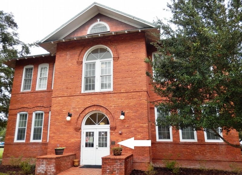
Little Red Schoolhouse
circa 1910 — — Map (db m126398) HM
On Newberry Lane at NW 245 Street, on the left when traveling west on Newberry Lane.
Lynching in America
Between 1877 and 1950, thousands of African Americans were the victims of lynching and racial violence in the United States. Florida had one of the highest per capita lynching rates in the nation, with dozens of racial . . . — — Map (db m186426) HM
On West Newberry Road (State Road 26) at Northwest 255th Street, on the right when traveling west on West Newberry Road.
Only after about 1870 did phosphates become an important world industry. In Alachua County, phosphates were discovered late in the 1870's, but as in other regions of Florida, the major developments in phosphate mining and processing began about . . . — — Map (db m119012) HM
On Northwest 166th Street at Northwest 20th Avenue, on the left when traveling north on Northwest 166th Street.
Side 1
On August 19, 1916, African Americans living in the Jonesville and Newberry communities were lynched. At 2:00 a.m., Constable George Wynne, Dr. L.G. Harris, and G.H. Blount drove to Boisey Long's home in Jonesville to serve a warrant and . . . — — Map (db m135956) HM
On US Hwy 27 & 41 (U.S. 27) at Northwest 16th Avenue, on the right when traveling north on US Hwy 27 & 41.
Blue Sink
Visited by William Bartram, America's first naturalist, in 1774.
Erected by Newberry Garden Club in cooperation with Dist. V. FFGC National Council of State Garden Clubs, Inc.
Fla. Dept. of Transportation — — Map (db m119044) HM
On County Road 234, on the right when traveling north.
Madison Starke Perry, born in Lancaster County, S.C., moved to Alachua County, Florida and became a prosperous planter. His plantation was located about six miles east of Gainesville in the area of present-day Rochelle. Perry was elected to the . . . — — Map (db m55537) HM
On County Road 234 at County Road 2082, on the left when traveling north on County Road 234.
Colonel Daniel Newnan led a troop of the Georgia militia on a raid into the area in September 1812 in an attempt to annex Florida to the United States in the War of 1812. The raiders engaged a force of Seminole Indians under the command of . . . — — Map (db m54642) HM
On Old Bellamy Road, 0.2 miles west of Northwest 173rd Road Street,, on the left when traveling west.
SPRING HILL UNITED METHODIST CHURCH
In 1860, after the era of circuit rider preachers, the local Methodists built a church. Five men, including Simeon Dell and Fernando Underwood, bought five acres on the Bellamy Road for $50. Though the price . . . — — Map (db m197956) HM
On Old Bellamy Road, 0.2 miles west of Northwest 173rd Road Street, on the left when traveling west.
Springhill Methodist Church
Organized-1860,
On the Bellamy Road
Present building erected,
1915
Educational annex a part of
Bland Church
1956
Traxler, Fla.
This community was named
Traxler in the late 1880's
when . . . — — Map (db m172727) HM
On Old Bellamy Road, 0.2 miles west of Northwest 173rd Road Street, on the left when traveling west.
Side 1
Country stores were critical for collecting farm crops and sending them to market. They played an important role in building commerce and establishing credit. The Traxler store was one of several in Alachua County that provided these . . . — — Map (db m197954) HM
Dickison and His Men
John Jackson Dickison (1816-1902), Florida's famous Civil War guerrilla leader, bivouacked at Camp Baker, south of here, during the closing weeks of the conflict. Dickison and his men became legendary figures. As Company . . . — — Map (db m40315) HM
On 5th Blvd (State Road 24 E), on the right when traveling east.
(Left)
Police Officer
Waldo
When I start my tour of duty God,
Wherever crime may be,
As I walk the darkened Streets alone,
let me be close to thee.
Please give me understanding
with both the young and old
Let me listen with . . . — — Map (db m41877) HM
On SW 5th Blvd. (State Road 24) near S.W. 2nd Way, on the right when traveling east.
The first permanent English-speaking settlers came to the northeast portion of Alachua County in the 1820's. In 1837, during the Second Seminole War, an army post, Fort Harlee, was established on the Santa Fe River about three miles north of this . . . — — Map (db m41072) HM
Near South Lowder Street south of West Railroad Avenue, on the right when traveling south.
When Alvarado A. Geitgey (pronounced Get-gee) moved to Baker County, he became legendary. A self-made prosperous and shrewd business man purchased large tracts of land in the area and began pecan groves, grape orchards, citrus groves and a dairy . . . — — Map (db m206585) HM
On South Lowder Street, 0.1 miles south of W Railroad Avenue.
In honor of our brother
Army SGT. Hubert L. Raulerson “Ranger”
Born Sept. 1, 1919 in Taylor
Son of George and Alma (Knapp) Raulerson
Killed in WWII action in Germany, Sept. 22, 1944
Lorene, Opal, Myrtice, T.J. James, . . . — — Map (db m206690) WM
Near South Lowder Street south of West Railroad Avenue, on the right when traveling south.
This building was donated to Heritage Park by the Baker County Board of Public Instruction for the purpose of a school museum. The exterior addition was made possible by a generous donation from Dewey and Lynn Burned in honor of his parents, Jimmy . . . — — Map (db m206912) HM
Near South Lowder Street south of West Railroad Avenue, on the right when traveling south.
In 1822-23, Florida's first Territorial Governor, Andrew Jackson, ordered a string of uniquely crafted block fortresses, with gun ports provided on the log walls, built for the purpose, of protecting pioneer settlers from hostile attacks. Only three . . . — — Map (db m206533) HM
Near South Lowder Street south of West Railroad Avenue, on the right when traveling south.
Once upon a time you could turn off Georgia Road 185 onto the peaceful rural land that led to the Clyde Sands compound, an exhilarating experience, that is, if you like country. On either side of the by-way, as far as the eye could see, was a . . . — — Map (db m206909) HM
On South Lowder Street, 0.1 miles south of W Railroad Avenue.
In honor of
Colonel John (1831-1891) and Clara H. Darby (1838-1880)
Founders of Darbyville
and son, Arthur Morgan and Ida Lee Wolfe Darby
Children: Ada Darby Jones, Susie Darby Marks, John Morgan
Darby, Mira Darby Peek, Mable Lee . . . — — Map (db m206764) HM
Near South Lowder Street south of West Railroad Avenue, on the right when traveling south.
Sadie & Corbett
"I was called Sugar Toes the first 7 years of my life until my Uncle Noah & Cousin Werth came riding up on a mule & asked daddy, "Dennis have you got a name for that boy yet?" My daddy said "Nope"! "Well, I got a name for him, . . . — — Map (db m206676) HM
B- July 17, 1896 — D- May 31, 1964
Graduate of Emory University Medical School, Atlanta, GA.
Organized Florida National Bank of Starke in late 1930’s
Baker County Physician 1920’s through 1940’s
Remembered by . . . — — Map (db m206570) HM
Near South Lowder Street, 0.1 miles south of W Railroad Avenue.
March 5, 1932 — Feb. 15, 2002
Born Taylor, FL; Son of Vandie & Sippie (Canaday) Harris
1950 Graduate M-GHS
Played on 1st Championship Basketball team 1948-1949
Graduate of U of FL 1st Pharmacy Class 1960
Pharmacist 42 years . . . — — Map (db m206588) HM
Near South Lowder Street south of West Railroad Avenue, on the right when traveling south.
This water powered windmill, once a source of water supply for the Woodlawn Cemetery-Association, was constructed by A.B. Hart, a pioneer settler (1913) of Hart's Trail Ridge east of McClenny. Mr. Hart's name, followed by the original spelling of . . . — — Map (db m206541) HM
Near South Lowder Street, 0.1 miles south of W Railroad Avenue.
To honor of our 5th g/g/father
Elisha Greene, Sr. 1790 - 1875
who arrived with the first wagon train of settlers
Baker County 1832. Settled on Greene’s Creek
south of Sanderson. Father of 19 children
1 - Wife Elizabeth . . . — — Map (db m206820) HM
On South Lowder Street, 0.1 miles south of W Railroad Avenue.
Elisha Greene arrived in Baker County on Christmas Day in 1830, leading the first wagon train of pioneer settlers.
Acting as advance scouts were William and Mose Barber, and other men acting as scouts.
Others traveling in the train were the . . . — — Map (db m206950) HM
Near Lowder Street just south of Railroad Avenue, on the right when traveling south.
Born August 15, 1923 in Seven Mile Camp in Columbia County. The son of Ernest Sr. and Sarah (Davis) Harvey. Mr. Harvey survived a horrific childhood with dignity and strength of character to become one of Baker County’s most beloved and respected . . . — — Map (db m206746) HM
On South Lowder Street, 0.1 miles south of W Railroad Avenue.
In honor of our Garrett Family
Pioneer settlers of North Baker County - Macedonia Area
William “Bill” (1841-1927) Co. D 1st FL Calvary CSA
and Henrietta Hogan Garrett (1855-1934)
Frank (1873) Lewis (1875) Rose (1877) . . . — — Map (db m206811) HM
Near Lowder Street just south of Railroad Avenue, on the right when traveling south.
Harold and Fay Matthews Milton's exceptional lives probably made the greatest impact on the development of Baker County's educational and social advancement more so than any other couple of their era of time. Modest in nature, their achievements . . . — — Map (db m206544) HM
Near South Lowder Street near West Railroad Avenue.
Ida Estelle Corbett born September 8, 1860 was the daughter of Charles C. Corbett and his wite Zilphia Crowningshield, natives of Vermont. A stone cutter and funeral director by trade, Charles, moved his family to the area now known as Baker County . . . — — Map (db m206911) HM
Near South Lowder Street south of West Railroad Avenue, on the right when traveling south.
Baxter Midwife
Born 1909
Ida Gainey was raised in the back woods of Baker County. A poor country girl with poor but honorable parents, Daniel and Laura Mizell Raulerson.
She married Otus Gainey at the age of 15 but hardships did not . . . — — Map (db m206586) HM
On South Lowder Street, 0.1 miles south of W Railroad Avenue.
Proud to be a Baker County Burnsed Descendant
Honoring
James M. Burnsed
Builder of the Burnsed Block House (Mid- 1830s)
and Fort Monica
Served in 1860s as Baker County Sheriff — — Map (db m206758) HM
Near South Lowder Street south of West Railroad Avenue, on the right when traveling south.
Lula Thrift, daughter of John Newton (born 1851) and Sally (Arnold) Sands (born1861) in the Georgia Bend Area stands in front of the home her husband Nathan Thrift built for her in 1919. At a cost of $25 the lumber was hauled from the sawmill by . . . — — Map (db m206543) HM
Near South Lowder Street, 0.1 miles south of W Railroad Avenue.
Interview 1993
Olustee Friends A.G. St. Johns and Vonceil (Dobson-Fraser) Alvarez
Introduction: Olustee was once a fort during Florida's territorial days as well as a Methodist sanctuary mission. It was once a bustling, busy . . . — — Map (db m206757) HM
On South Lowder Street, 0.1 miles south of W Railroad Avenue.
Otis March 21, 1917 - February 12, 2001
Mattie May 21, 1920 -
Otis Canady was born south of Moniac, the only child of Aaron & Rosa Mae (Rhoden) Canady. Otis fell in love with Mattie, the daughter of Thomas & Mary (Thrift) Crews . . . — — Map (db m206629) HM
Near Lowder Street just south of Railroad Avenue, on the right when traveling south.
Walter Monroe Turner 1856-1931
Son of Charles and Martha (Fraker) Turner
Husband of Lillian Elizabeth Sessions 1862-1929
Walter Monroe Turner was Postmaster in Macclenny for 18 years. He and his wife, Lillian reared four sons and two . . . — — Map (db m206608) HM
Near Battlefield Trail, 0.4 miles north of U.S. 90.
At this point in the battle, the Union had five cannons
captured and nearly every other cannon was
rendered useless. “The horses and men were nearly all
killed or wounded, and it was the greatest slaughter
among artillery known in the . . . — — Map (db m146303) HM
(Left side text) During the Great Depression, President Roosevelt approved a plan to recruit thousands of unemployed young men
into a "Civilian Conservation Corps" (CCC)
From 1933-1942 the CCC employed over 3 million Americans. They . . . — — Map (db m55674) HM
Near Battlefield Trail, 0.2 miles north of U.S. 90.
Here was fought on February 20, 1864
the Battle of Ocean Pond
under the immediate command of
General Alfred Holt Colquitt
"Hero of Olustee"
This decisive engagement prevented a
Sherman-like invasion of Georgia from
the south. . . . — — Map (db m54361) HM
Near Michael Cason Road east of 17 Mile Camp Road, on the right when traveling west.
Front
To the memory of
the officers and
soldiers of the
United States Army
who fell in
the Battle of
Olustee
February 20, 1864
This memorial replaces
the original wooden one
erected in this site
May . . . — — Map (db m146335) HM
Near Battlefield Trail (17 Mile Camp Road), 0.3 miles north of U.S. 90, on the right when traveling north.
Placed by
The United Daughters
of the Confederacy
Florida Division
In Memory of
Brig. Gen.
Joseph Finegan
Commander of the District of
Middle and East Florida
"So well did he perform
his part that a . . . — — Map (db m54978) HM
Near Battlefield Trail, 0.3 miles north of U.S. 90.
By 3:00 p.m. the 7th New Hampshire deployed on the
Union right flank, battling heavy fire from the
Confederates. The regiment had earlier been ordered to
exchange their Spencer repeating rifles for old, defective
muskets; many of which did . . . — — Map (db m146294) HM
Near Battlefield Trail, 0.3 miles north of U.S. 90.
Colquitt's brigade gradually advanced until they were
nearly on the enemy's left flank. The Yankees broke
and fled, and the Rebels knew they had won.
“The whole line moving as directed, the enemy gave
way in confusion. We continued . . . — — Map (db m146329) HM
When the two armies met in force, the Union troops
their advance and the other blocking their retreat. They
could see for long distances and there was very little
cover in which to hide. To the north was an old, cleared
field where later the . . . — — Map (db m146282) HM
Near Battlefield Trail, 0.4 miles north of U.S. 90.
About the time the North felt the day was lost, the
54th Massachusetts and the 1st North Carolina U.S.
Colored advanced, staggering the enemy for a moment.
Around 5:00 p.m. the fire slackened on both sides as
soldiers were running out of . . . — — Map (db m146311) HM
On Battlefield Trail, on the left when traveling north.
(Left Panel)
Welcome to the Olustee Battlefield
Battlefield Map included with Park
rules and regulations
(Center Panel)
How Many Would Die ?
The morning of February 20, 1864,
dawned clear and cool. . . . — — Map (db m54917) HM
Near Battlefield Trail, 0.3 miles north of U.S. 90.
"After three hours of fighting, every regiment
excepting the 115th New York had been compelled
to leave the field. Our boys occupied precisely the same
position which they did at the opening of the battle.
They stood battling over the bodies . . . — — Map (db m146317) HM
Near Battlefield Trail (17 Mile Camp Road), 0.3 miles north of U.S. 90.
Around 2:00 p.m. Union troops reached a railroad
crossing east of Olustee. Here they faced increased
resistance from the advancing Confederate troops.
The 7th Connecticut opened up with heavy fire from
their Spencer repeating rifles, . . . — — Map (db m146286) HM
On Battlefield Trail at U.S. 90, on the right when traveling west on Battlefield Trail.
(Front):The Battle of Olustee was fought on this ground February 20th, 1864. Between 5,000 Confederate troops commanded by General Joseph E. Finegan and 6,000 Federal troops under General Truman Seymour. The Federals were defeated with a loss . . . — — Map (db m13708) HM
Around 3:00 p.m. Colonel Harrison arrived with
Confederate reinforcements and General Colquitt
ordered the troops to advance. Colonel Barton's brigade
for the North was soon subjected to concentrated fire in
the area recently vacated by the . . . — — Map (db m146298) HM
Near Battlefield Trail (17 Mile Camp Road), 0.3 miles north of U.S. 90, on the left when traveling north.
Marching west, the Union forces left Barber's
Plantation at 6:00 a.m., expecting to defeat the
Confederates 32 miles away in Lake City. If successful,
the Union then planned to cut off railroad
communications between east and west . . . — — Map (db m54829) HM
This site was used by both Union and Confederate soldiers as a camp during the campaign of 1864. The camp was used as a Confederate supply depot but it was abandoned on February 9, 1864. From the 9th to the 13th, it was held by Federals and used as . . . — — Map (db m54604) HM
Near Interstate 10 at milepost 318,, 0.6 miles west of 17 Mile Camp Road, on the right when traveling east.
Did you know the first people in North Florida lived here 10,000 years ago?1562
Timucuans
The Timucuans were the Native Floridians living in north and central Florida when the Europeans arrived in 1562. Powerful and . . . — — Map (db m159960) HM
On Beulah Avenue, 0.1 miles south of Minneola Street, on the right when traveling south.
The Callaway School House was built in 1911 (two years prior to the creation of Bay County in 1913) on the SW corner of Beulah Avenue and Letohattchee Street. Callaway had been surveyed and platted in 1908 by Pitt Milner Callaway for whom the . . . — — Map (db m73287) HM
On U.S. 98 at Canal Parkway, on the right when traveling east on U.S. 98.
Built in 1919 for the British Navy, this 170-foot steamer originally was christened Kilmarnock. Admiral Richard E. Byrd purchased the ship for use in his Antarctic expedition of 1928-30 and renamed her Eleanor Bolling in honor of . . . — — Map (db m73753) HM
On Grace Avenue at West 10th Street, on the left when traveling north on Grace Avenue.
This house at 941 Grace Avenue was built by Maude and Earle Thompson in 1924. The couple lived here with their three children who retained possession of the house until 2008. The Thompson family were among the first citizens of Panama City and . . . — — Map (db m245298) HM
On West 11th Street east of Beck Avenue, on the right when traveling east.
Road and bridge construction during the Roosevelt administration of the 1930's made automobile travel easier and more common. In Florida, tourists stayed in "motor courts" like this one. C. M. Kelly owned several properties and businesses including . . . — — Map (db m245331) HM
On Harrison Avenue at East Beach Drive, on the left when traveling south on Harrison Avenue.
The first brick building in Panama City was completed in 1911 and housed Panama City's first bank. The bank closed in 1915 and was occupied by various businesses over the years. In 1941 Leslie Miller Gilbert opened Less Gilbert's Bay Shore Bar and . . . — — Map (db m245134) HM
On Beck Avenue at 10th Street, on the right when traveling north on Beck Avenue.
Bay County's Oldest Bank was originally a beautiful one-story building of old style concrete block or cement Stone (earlier referred to as "artificial stone"). It is the only remaining example of this particular old style craftsmanship left in Bay . . . — — Map (db m245304) HM
On North Center Avenue south of East 2nd Plaza, on the right when traveling south.
This one-story house originally sat on the curve of E. Hwy. 98 across from the "Martin House." It was built circa 1911 by the Moore Timber Company and used as one of the many homes for those employed at the big sawmill operation from 1910-1922. It . . . — — Map (db m245437) HM
Near Chestnut Avenue at 9th Street, on the right when traveling south.
In this park are the remains of a Native American settlement occupied sometime between AD 1200 and 1500. Archaeological studies at this site, called the Buena Vista Site 8BY878 documented that this was probably a small, temporary settlement where . . . — — Map (db m245323) HM
On Harrison Avenue south of East 4th Street, on the right when traveling north.
After a fire and explosion destroyed the Panama Motor Co. building on this site in 1930, W. J. Cook and wife Estelle, sister of former owner Fred T. Bennett, had erected the new Cook Motor Co. The large building had, from left to right, a display . . . — — Map (db m245255) HM
On Lisenby Avenue, 0.1 miles north of West 15th Street (U.S. 98), on the left when traveling north.
Covington Cemetery officially dates to 1917 when Richard Covington, a successful African American truck farmer and landowner, buried his wife Laura on this plot of land. The Cemetery grew from a private graveyard to a larger sacred space where Black . . . — — Map (db m245349) HM
On East 3rd Street east of Sherman Avenue (Florida Route 22), on the left when traveling east.
This building was erected in 1930 by Dr. A. H. Miller after a massive fire that destroyed the earlier business structures located at this corner of the "Parker-Millville Road." The fire occurred on November 30, 1929. After Dr. Miller had this new . . . — — Map (db m245480) HM
On Beck Avenue (Florida Route 30) south of West 14th Street, on the right when traveling north.
This fast food ice cream and hamburger shop was established by Harold L. & Dorothy Dunton. Tastee-Freez was one of the first soft serve franchises in the Nation. Subsequent owners included Mrs. Roberta Elder, Dana E. Wright and Galen Mielke. In . . . — — Map (db m245505) HM
On North Center Avenue at East 4th Street, on the left when traveling south on North Center Avenue.
Built in 1925 by A.L. Barber and wife Bonnie E. Dykes. It was owned and occupied by Clara M. Dykes and husband Donald E. Emanuel after 1925. It still remains in the ownership of the Emanuel family descendants. Both the Dykes and the Emanuel families . . . — — Map (db m245382) HM
On West Beach Drive west of Flower Avenue, on the right when traveling west.
John Clark, Governor of Georgia from 1819 to 1823, built and lived in a lodge-style home on this site in 1827. He and his family died of yellow fever in 1832 and were buried on the property. In 1923, the headstones and remains were returned to . . . — — Map (db m245737) HM
On West 16th Street at Drummond Avenue, on the right when traveling west on West 16th Street.
This building was originally constructed on Brackin's Wharf, located at the south end of Drummond Avenue and was used as a warehouse and fish house. The building was moved to the present site in 1917 and used as a residence to this day. — — Map (db m245515) HM
Near Collegiate Drive, 0.1 miles north of West 23rd Street, on the right when traveling south.
"This flagstaff and American flag that flies upon it are dedicated to members of our country’s armed forces - - past, present and future. Their sacrifices preserve a republic whose vitality derives from the freedom to acquire knowledge and the . . . — — Map (db m246615) WM
On Moore Circle north of West Beach Drive (Florida Route 30), on the left when traveling north.
A charming bungalow built by H. W. Johnson for his family. The property was a wedding gift to Johnson's first bride from his uncle, G. B. Thompson. From 1910 to 1924 Monte and Lillie Pickens, founder of St. Andrews Conservatory of Music and Oratory . . . — — Map (db m245635) HM
Near Lisenby Avenue at West 23rd Street, on the left when traveling south.
Prior to March 24th,1949, black people were buried in private cemeteries. One of these cemeteries was on Balboa Avenue between the Nelson School District Administrative building and the Goodyear Auto Service Center. On July 25, 1949 Mr. and Mrs. Joe . . . — — Map (db m245493) HM
On Chesnut Avenue at West 11th Street, on the left when traveling south on Chesnut Avenue.
The St. Andrew Methodist Episcopal Church was organized in St. Andrews in 1886 and construction of this sanctuary was completed in 1887. In 1939, $600.00 was borrowed to add the front foyer, which covered the glass panes above the door. To alleviate . . . — — Map (db m245302) HM
On Beck Avenue (Florida Route 30) at West 14th Street, on the right when traveling south on Beck Avenue.
The St. Andrews Presbyterian Church was organized September 13, 1886 at 4:00 PM in the home of Mr. Hiram M. Mapes. The church roll was comprised of 16 members. For little more than a year, the small band of Presbyterians met at the homes of members . . . — — Map (db m245511) HM
On North Church Avenue at East 2nd Street, on the right when traveling north on North Church Avenue.
This house was built as a “replacement Home” in 1918 when Lewis S. & wife Jane Holmes Anderson left the “Holmes homestead on the peninsula “ along with Mrs. Wesley Holmes to make way for the new "Sherman Shipyard", to be built. It would be "home" to . . . — — Map (db m245632) HM
On West 10th Street at Beck Avenue, on the right when traveling east on West 10th Street.
When the Spanish passed through between the years 1516 and 1558, this area was inhabited seasonally by the Chatot and Yuchi Native American tribes. Shortly after contact, the Chatot became extinct (as did more than 90% of Florida native . . . — — Map (db m245641) HM
On West 9th Street (Business U.S. 98) east of Chestnut Avenue, on the right when traveling east.
After the Lynn Haven Hotel burned in 1929, one of the hotel’s cottages was moved by barge to this site, and pulled on rollers by mule to its place as the west wing of the home. In 1934, the east wing of the home was completed. This home is for . . . — — Map (db m245521) HM
On Harrison Avenue south of East 4th Street, on the right when traveling north.
This building housed the first "photo play theater" to open successfully in the Downtown. The 30 foot by 100 foot building was constructed on steel lath with stuccoed exterior. The owner and manager, J. Arthur Smith, had opera chairs installed that . . . — — Map (db m245247) HM
On East 2nd Court east of East Beach Drive, on the right when traveling east.
This house was built 1910 by Henry S. Harmon and sold to his kinsman John Marlin Sessions in 1913. Both men were experienced sawmill men who worked the nearby lumber on Massalina Bayou to provide materials for much needed new houses in the brand-new . . . — — Map (db m245232) HM
On West Beach Drive at Balboa Avenue, on the right when traveling west on West Beach Drive.
(side A)
Built in 1927 by A.A. Payne, a banker, and bought by John Christo, Sr., the house is significant in architecture, a mixture of styles typical of the late 19th and early 20th centuries which includes Neo-Colonial Revival and . . . — — Map (db m42117) HM
On Harrison Avenue south of West 6th Street, on the right when traveling south.
This building was built between 1926 and 1933 by W.L. Folkes. It was previously known as the Panama City Milk and Cream Company and in 1935 as Bayhead Dairies, the largest and most complete dairy products organization in the community at that time. . . . — — Map (db m245351) HM
On Harmon Avenue at East 1st Court, on the left when traveling north on Harmon Avenue.
Built on an Indian midden in 1912 by W.A. and Sylvia Kelly as a bungalow cottage, this home was purchased in 1948 by Brown and Estelle Howell, who remodeled in 1952 and turned it into a ranch style house. The Howells changed the entrance from First . . . — — Map (db m245229) HM
On Harmon Avenue at Cherry Street, on the right when traveling north on Harmon Avenue.
Leon DeVoe "Voe" and Kate Harmon built this home in 1908 on family land that was purchased in 1876 and would later become known as the Harmon Plat.
L.D. "Voe" was a mill superintendent, Panama City town councilman, and a licensed real estate . . . — — Map (db m245182) HM
On Martin Luther King Jr Bpulevard (Florida Route 77) at East 11th Street, on the right when traveling south on Martin Luther King Jr Bpulevard.
Lee's Gulf Service Station which later changed to Lee's BP was owned by Edward Lee, Sr. This was a very successful business and allowed both blacks and whites to purchase fuel and associated supplies within the community.
Dan Lee says, "Each . . . — — Map (db m245081) HM
On Martin Luther King Jr Boulevard (U.S. 98) at 11th Court, on the right when traveling south on Martin Luther King Jr Boulevard.
The Lincoln Theater, opened by the Bailey Theater chain in November 1950, stood as one of the last bastions of "colored theaters" where African Americans could enjoy movies and entertainment during a time of segregation. Operating until 1957, it . . . — — Map (db m245087) HM
On Chestnut Avenue south of 10th Street, on the right when traveling south.
It is believed the Lion Fountain (c. 1910s) was located at the Pines Hotel that once stood adjacent to the Panama City Depot off Beach Drive where today's Chevron tanks are. Many locals called the fountain a "horse trough" during its time near the . . . — — Map (db m245312) HM
On Oak Avenue at Park Avenue, on the left when traveling east on Oak Avenue.
In 1887, this block was set aside by the original Downtown developers, George W Jenks, and C. J. Demorest. Streets were laid out around the park, and it is evident from the plat of May 23, 1888, that it was the focal point of the small community. . . . — — Map (db m245178) HM
On East Beach Drive at East First Court, on the left when traveling east on East Beach Drive.
This cottage style home was built on an Indian midden by early business developer George H. McKenzie and his wife Frances. It was purchased in 1928 by Professor Monte Pickens, a renowned musician. It remained in the Pickens family until . . . — — Map (db m245173) HM
On Harmon Avenue at East Second Place, on the right when traveling north on Harmon Avenue.
This house was built in 1908 by Miles Lampkin "Lamp" and wife Mary Honora "Nora" Purcell Harmon. "Lamp", born in 1871, was the son of original settlers Turner Hunt and Nancy Harmon. "Lamp" was one of the thirty one qualified voters that signed the . . . — — Map (db m245197) HM
On Harmon Avenue at East Second Street, on the left when traveling north on Harmon Avenue.
Joseph Sihelnik bought this vacant property in 1932 and built a combination store and dwelling on the land to be used by his niece, Miss Maggie Slicho. The store was sometimes known as Cove Grocery and was operated by Maggie until 1948 when it was . . . — — Map (db m245203) HM
On Elm Avenue at East 7th Street, on the right when traveling north on Elm Avenue.
New Bethel Missionary Baptist Church was founded by Rev. Walter and Sister Mary Jackson on December 10, 1908. The original name for the church was Missionary Baptist Church of Washington County in the State of Florida. Millville was in Washington . . . — — Map (db m245471) HM
On Balboa Avenue at West 10th Court, on the right when traveling north on Balboa Avenue.
The first known burial on this land was that of Arminda Mosher in 1895. She had come to the area with her husband Elijah, and died at the age of 51.
When George M. West moved here permanently in 1906 he founded the Gulf Coast Development . . . — — Map (db m244973) HM
On East 3rd Street east of Sherman Avenue, on the left when traveling east.
Charles and Eunice Cotton moved to Millville in 1909 and opened a 'General Merchandise Store" in this building and operated it successfully for the next six years. In 1915, he sold out his interests to the Brigman family. It became "Brigman & Co.". . . . — — Map (db m245355) HM
On Airport Road (County Road 391), on the left when traveling west. Reported missing.
Established 1945 on Fannin Field Panama City-Bay County Airport 1964 Panama City-Bay County Airport and Industrial District 1967 Developed and controlled by Representative Airport Authorities in conjunction with the Federal Aviation Agency Control . . . — — Map (db m221885) HM
On East 7th Street at Luverne Avenue, on the left when traveling east on East 7th Street.
The Panama City High School was the first modern school in Bay County. The property, amounting to 5.16 acres, was given by the Gulf Coast Development Company to the trustees of special school district number twelve of Bay County. Ground for the . . . — — Map (db m245482) HM
On Beck Avenue at West 11th Court, on the left when traveling south on Beck Avenue.
Constructed by George M. West, one of the "founding fathers" of Panama City, it was at this site that Mr. West and his wife Lillian Carlisle West "Miss Lillian" published three local newspapers, numerous books and promotional materials for economic . . . — — Map (db m245045) HM
On East 3rd Court at Park Street, on the right when traveling west on East 3rd Court.
(Front Side): The McKenzie House is a large two-story clapboard frame dwelling built in the Dutch Colonial style typical of the turn of the century houses still standing in Northern Michigan. It was built 1909 by Belle Booth who married R. . . . — — Map (db m8155) HM
On Bay Avenue at East 9th Court, on the left when traveling south on Bay Avenue.
In 1913, Jewish philanthropist and Sears, Roebuck and Company chairman, Julius Rosenwald, joined African American rights activist Booker T. Washington of the Tuskegee Normal and Industrial Institute to help support a project to design and operate . . . — — Map (db m192362) HM
On Martin Luther King Jr Boulevard (Florida Route 77) south of 11th Court, on the right when traveling south.
After moving to Panama City Florida in late 1947 Morise and Clera opened Russ Shoe Shop at 1107 Cove Blvd. in 1949. Their shoe repair business was to become a pillar of the Glenwood community. About 1960, the Russ family built a new building next . . . — — Map (db m245084) HM
6708 entries matched your criteria. Entries 201 through 300 are listed above. ⊲ Previous 100 — Next 100 ⊳