409 entries match your criteria. The first 100 are listed. ⊳
Historical Markers and War Memorials
in Eastern Kentucky Region
By Craig Doda, July 27, 2020
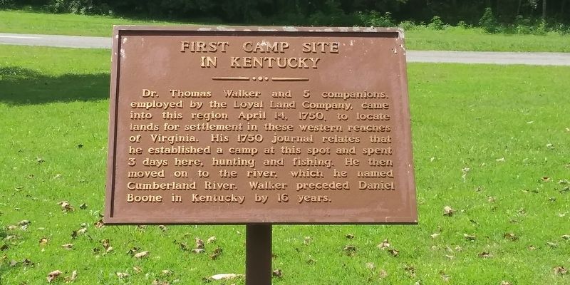
First Camp Site In Kentucky Marker
1 ► Kentucky, Bell County, Clear Creek Springs — First Camp Site In Kentucky —  |
| On Paula Drive (County Road 190) just west of U.S. 25E, on the right when traveling west. | |||
| 2 ► Kentucky, Bell County, Clear Creek Springs — 1286 — Henderson Settlement — Settlement is 17 miles west on Ky 190 — |
| On State Highway 190 at U.S. 25E, on the right when traveling east on State Highway 190. | |||
| 3 ► Kentucky, Bell County, Ewing — Indian Rock — |
| Near Pinnacle View Road 0.7 miles south of Kentucky Route 986, on the right when traveling south. | |||
| 4 ► Kentucky, Bell County, Middlesboro — "This American Gibraltar" — |
| Near Pinnacle Road, on the right when traveling east. | |||
| 5 ► Kentucky, Bell County, Middlesboro — 521 — A Masterful Retreat — |
| Near Old Wilderness Road (Kentucky Route 988) at Pinnacle View Road, on the right when traveling north. | |||
| 6 ► Kentucky, Bell County, Middlesboro — An Object Lesson Road — Cumberland Gap National Historical Park — National Park Service, U.S. Department of the Interior — |
| Near Sugar Run Overlook Road (Kentucky Route 988). | |||
| 7 ► Kentucky, Bell County, Middlesboro — An Object Lesson Road — Cumberland Gap National Historical Park — National Park Service, U.S. Department of the Interior — |
| Near Sugar Run Overlook Road (Kentucky Route 988). | |||
| 8 ► Kentucky, Bell County, Middlesboro — 129 — Colonel Arthur Campbell — |
| On North 24th Street at Gloucester Avenue, on the right when traveling north on North 24th Street. | |||
| 9 ► Kentucky, Bell County, Middlesboro — Community Park to National Park — Cumberland Gap National Historical Park — |
| Near Bartlett Park Road 0.4 miles south of Pinnacle View Road, on the right when traveling south. | |||
| 10 ► Kentucky, Bell County, Middlesboro — 2450 — Cumberland Gap / Grant Visits Cumberland Gap — |
| Near Old Wilderness Road (Kentucky Route 988) at Pinnacle View Road, on the right when traveling north. | |||
| 11 ► Kentucky, Bell County, Middlesboro — Daniel Boone Trail — |
| On Wilderness Road Trail. | |||
| 12 ► Kentucky, Bell County, Middlesboro — Daniel Boone's Trail — |
| Near Wilderness Road Trail. | |||
| 13 ► Kentucky, Bell County, Middlesboro — Daniel Boone's Trail — |
| On Wilderness Road Trail. | |||
| 14 ► Kentucky, Bell County, Middlesboro — Defense of the Gap |
| Near Pinnacle Road, on the right when traveling east. Reported permanently removed. | |||
| 15 ► Kentucky, Bell County, Middlesboro — Dirt-and-Log Forts — Cumberland Gap National Historical Park |
| On Pinnacle View Road 1.7 miles east of Route 988. Reported missing. | |||
| 16 ► Kentucky, Bell County, Middlesboro — Dirt-and-Log Forts — Cumberland Gap National Historical Park — |
| Near Pinnacle View Road 1.7 miles east of Old Wilderness Road ( Route 988), on the left when traveling east. | |||
| 17 ► Kentucky, Bell County, Middlesboro — Forts and Batteries, North and South — Cumberland Gap National Historical Park — |
| Near Pinnacle View Road 1.1 miles east of Old Wilderness Road ( Route 988), on the right when traveling east. | |||
| 18 ► Kentucky, Bell County, Middlesboro — Gateway to Kaintuck — |
| On Pinnacle Road, on the right when traveling east. | |||
| 19 ► Kentucky, Bell County, Middlesboro — Gateway to Kaintuck — Cumberland Gap National Historical Park — |
| On Pinnacle View Road 2.5 miles east of Old Wilderness Road ( Route 988), in the median. | |||
| 20 ► Kentucky, Bell County, Middlesboro — Gateway to Kaintuck — Cumberland Gap National Historical Park — National Park Service, U.S. Department of the Interior — |
| On Pinnacle View Road 2.5 miles east of Old Wilderness Road ( Route 988), in the median. | |||
| 21 ► Kentucky, Bell County, Middlesboro — Invasion through the Gap |
| Near Pinnacle Road, on the right when traveling east. Reported permanently removed. | |||
| 22 ► Kentucky, Bell County, Middlesboro — Leave Nothing Useful Behind — Cumberland Gap National Historical Park — |
| On Wilderness Road Trail, on the left when traveling west. | |||
| 23 ► Kentucky, Bell County, Middlesboro — 2217 — Lewis and Clark in Kentucky Cumberland Gap — Cumberland Gap — |
| On U.S. 25E, on the right when traveling east. | |||
| 24 ► Kentucky, Bell County, Middlesboro — Middlesboro Country Club — |
| On Cirencester Avenue at North 28th Street, on the right when traveling west on Cirencester Avenue. | |||
| 25 ► Kentucky, Bell County, Middlesboro — 1262 — Middlesboro Golf Club — |
| Near North 28th Street 0.2 miles north of Cirencester Avenue, on the left when traveling north. | |||
| 26 ► Kentucky, Bell County, Middlesboro — 2225 — Middlesboro Meteorite Crater Impact Site — |
| On 12th Street (U.S. 25E), on the right when traveling north. | |||
| 27 ► Kentucky, Bell County, Middlesboro — 832 — Middlesborough — |
| On North 20th Street south of Lothbury Avenue, on the right when traveling south. | |||
| 28 ► Kentucky, Bell County, Middlesboro — 1227 — Mountain Vision — |
| On Cumberland Avenue. | |||
| 29 ► Kentucky, Bell County, Middlesboro — 1228 — Oldest House — |
| On 19th Street (Route 2079) at Hurst Road, on the right when traveling north on 19th Street. | |||
| 30 ► Kentucky, Bell County, Middlesboro — Pinnacle of Perfection — Cumberland Gap National Historical Park — |
| Near Pinnacle View Road. | |||
| 31 ► Kentucky, Bell County, Middlesboro — Pinnacle Overlook — |
| On Pinnacle Road, on the right when traveling east. | |||
| 32 ► Kentucky, Bell County, Middlesboro — Pinnacle Overlook — Cumberland Gap National Historical Park — |
| Near Pinnacle View Road 2.5 miles east of Old Wilderness Road ( Route 988), in the median. | |||
| 33 ► Kentucky, Bell County, Middlesboro — St. Mary's Episcopal Church — |
| On Englewood Road 0.2 miles west of North 20th Street, on the left when traveling west. | |||
| 34 ► Kentucky, Bell County, Middlesboro — Stories of a journey through the Wilderness, into Kentucke.. — |
| On U.S. 25 East, on the right when traveling east. | |||
| 35 ► Kentucky, Bell County, Middlesboro — The Emigrant's Dream — |
| On Pinnacle Road, on the right when traveling east. | |||
| 36 ► Kentucky, Bell County, Middlesboro — The Old Home Place — Cumberland Gap National Historical Park — |
| On Sugar Run Overlook Road (Kentucky Route 988), on the right when traveling north. | |||
| 37 ► Kentucky, Bell County, Middlesboro — Top Guns — Cumberland Gap National Historical Park — National Park Service, U.S. Department of the Interior — |
| Near Pinnacle View Road 2.5 miles Old Wilderness Road ( Route 988) when traveling east. | |||
| 38 ► Kentucky, Bell County, Middlesboro — Tri - State Heroes — Desert Storm — Preserving World Peace — |
| On 20th Street. | |||
| 39 ► Kentucky, Bell County, Middlesboro — Two Armies, One Railroad — Cumberland Gap National Historical Park — |
| Near Pinnacle View Road 1.1 miles east of Old Wilderness Road ( Route 988), on the right when traveling east. | |||
| 40 ► Kentucky, Bell County, Middlesboro — Two-Way Traffic — Cumberland Gap National Historical Park — National Park Service, U.S. Department of the Interior — |
| On Pinnacle Road, on the right when traveling east. | |||
| 41 ► Kentucky, Bell County, Middlesboro — Waiting for the Battle that Never Came |
| Near Pinnacle Road, on the right when traveling east. Reported permanently removed. | |||
| 42 ► Kentucky, Bell County, Middlesboro — Warriors' Path — Cumberland Gap National Historical Park — National Park Service, U.S. Department of the Interior — |
| Near Thomas Walker Trail 0.2 miles east of Pinnacle View Road, on the right when traveling east. | |||
| 43 ► Kentucky, Bell County, Middlesboro — 1402 — Watts Furnaces / Iron Made in Kentucky — |
| On 12th Street (U.S. 25E) at 14th Street East, on the right when traveling south on 12th Street. | |||
| 44 ► Kentucky, Bell County, Middlesboro — Wilderness Road — Then and Now — Cumberland Gap National Historical Park — |
| Near Pinnacle View Road. | |||
| 45 ► Kentucky, Bell County, Pineville — Bell County War Dead Memorial — |
| On Kentucky Avenue. | |||
| 46 ► Kentucky, Bell County, Pineville — Chained Rock — |
| Near Chained Rock Road 4 miles east of 382, on the right when traveling east. | |||
| 47 ► Kentucky, Bell County, Pineville — 1426 — Cumberland Ford — |
| On Bob Madon Bypass (U.S. 25E) at Pine Street (State Highway 66), on the right when traveling west on Bob Madon Bypass. | |||
| 48 ► Kentucky, Bell County, Pineville — Daniel Boone's Trail — |
| On Courthouse Square. | |||
| 49 ► Kentucky, Bell County, Pineville — 683 — Invasion and Retreat — |
| On State Park Road (Kentucky Route 382) west of Chained Rock Road, on the right when traveling north. | |||
| 50 ► Kentucky, Bell County, Pineville — 198 — Joshua Fry Bell — |
| On Kentucky Avenue at Pine Street ( Highway 66), on the right when traveling east on Kentucky Avenue. | |||
| 51 ► Kentucky, Bell County, Pineville — Mountain Gateway — |
| On Kentucky Avenue at Pine Street ( Highway 66), on the right when traveling east on Kentucky Avenue. | |||
| 52 ► Kentucky, Bell County, Pineville — 2045 — Naming of the Cumberland River — |
| On U.S. 25E, on the right when traveling north. | |||
| 53 ► Kentucky, Bell County, Pineville — The Wilderness Road — |
| On State Park Road (Kentucky Route 382), on the right when traveling north. | |||
| 54 ► Kentucky, Bell County, Pineville — 54 — The Wilderness Road — |
| On Bob Madon Bypass (U.S. 25E) south of Park Avenue, on the left when traveling south. | |||
| 55 ► Kentucky, Bell County, Pineville — 1272 — Wallsend Mine — |
| On Bob Madon Bypass (U.S. 25E) at Tennessee Avenue, on the right when traveling west on Bob Madon Bypass. | |||
| 56 ► Kentucky, Bell County, Pineville — Wilderness Road Cemetery — |
| On Asher-Clear Creek Road at U.S. 25E, on the right when traveling east on Asher-Clear Creek Road. | |||
| 57 ► Kentucky, Breathitt County, Jackson — 641 — "Bloody Breathitt" — |
| On Main Street. | |||
| 58 ► Kentucky, Breathitt County, Jackson — 669 — Bitter Antagonism |
| On Old Kentucky 15 (Kentucky Route 205) 3 miles Jackson. Reported missing. | |||
| 59 ► Kentucky, Breathitt County, Jackson — 961 — Breathitt County — |
| On Main Street. | |||
| 60 ► Kentucky, Breathitt County, Jackson — 904 — Breathitt Volunteers — |
| On Main Street. | |||
| 61 ► Kentucky, Breathitt County, Jackson — Broken Column — |
| On Main Street. | |||
| 62 ► Kentucky, Breathitt County, Jackson — Korean War Memorial — |
| On Main Street at Brown Street on Main Street. | |||
| 63 ► Kentucky, Breathitt County, Jackson — Willie Sandlin — |
| On Main Street. | |||
| 64 ► Kentucky, Breathitt County, Jackson — World War I Memorial — |
| On Main Street at Brown Street on Main Street. | |||
| 65 ► Kentucky, Breathitt County, Morris Fork — 1289 — Sam and Nola of Morris Fork — |
| On Kentucky Route 28 at Ingol Fory Road, on the right when traveling east on Kentucky Route 28. | |||
| 66 ► Kentucky, Breathitt County, Quicksand — 841 — Quicksand — 1864 — Confederate Raids and Invasions, and a Federal Retreat, in Kentucky — |
| On Kentucky Route 15 at Route 1089, on the left when traveling north on Kentucky Route 15. | |||
| 67 ► Kentucky, Clay County, Beverly — 723 — Log Cabin, Pre-1800 — |
| On Queendale Center at Dorm Road, on the right when traveling north on Queendale Center. | |||
| 68 ► Kentucky, Clay County, Manchester — 568 — A Masterful Retreat — Confederate Raids and Invasions, and a Federal Retreat, in Kentucky — |
| On Kentucky Route 11 0.4 miles south of U.S. 421, on the right when traveling south. | |||
| 69 ► Kentucky, Clay County, Manchester — 836 — County Named, 1806 — |
| On County Route 11, on the left when traveling north. | |||
| 70 ► Kentucky, Clay County, Manchester — 531 — Goose Creek Salt Works — |
| On Kentucky Route 11 0.4 miles south of U.S. 421, on the right when traveling south. | |||
| 71 ► Kentucky, Clay County, Manchester — 1929 — Gov. Bert T. Combs (1959-1963)/Bert T. Combs (1911 – 1991) — |
| On Town Branch Road, on the right when traveling west. | |||
| 72 ► Kentucky, Clay County, Manchester — Salt Works was located along the old Warrior's Path — |
| Near Railroad Avenue south of Poplar Street, on the right when traveling south. | |||
| 73 ► Kentucky, Clay County, Manchester — This Site is Birth Place of Local History — |
| Near Railroad Avenue south of Poplar Street, on the right when traveling south. | |||
| 74 ► Kentucky, Clay County, Oneida — 908 — Chief Red Bird — |
| On State Highway 66 0.6 miles north of U.S. 421, on the right when traveling south. | |||
| 75 ► Kentucky, Clay County, Oneida — John Gilbert, Sr. Memorial Highway — |
| On State Highway 66 0.6 miles north of U.S. 421, on the right when traveling south. | |||
| 76 ► Kentucky, Clay County, Oneida — 2024 — Oneida Baptist Institute — |
| On College Street south of River Street, on the right when traveling south. | |||
| 77 ► Kentucky, Floyd County, David — 151 — Boone Salt Springs — |
| On Kentucky Route 404, on the right when traveling east. | |||
| 78 ► Kentucky, Floyd County, David — Daniel Boone’s Salt Lick — |
| On Kentucky Route 144, on the right when traveling east. | |||
| 79 ► Kentucky, Floyd County, Ivel — Struggle for the Big Sandy Valley — |
| On U.S. 23 at County Road 1032, on the right when traveling east on U.S. 23. | |||
| 80 ► Kentucky, Floyd County, Ivel — The Battle of Ivy Mountain — |
| On U.S. 23 at County Road 1032, on the right when traveling east on U.S. 23. | |||
| 81 ► Kentucky, Floyd County, Ivel — The Battle of Ivy Mountain — November 8, 1861 — |
| On U.S. 23 at County Road 1032, on the right when traveling east on U.S. 23. | |||
| 82 ► Kentucky, Floyd County, Prestonburg — Civil War Event — |
| On South Lake Drive at West Court Street, on the right when traveling south on South Lake Drive. | |||
| 83 ► Kentucky, Floyd County, Prestonburg — Early Commerce — |
| On South Front Avenue just south of Richmond Plaza, on the right when traveling south. | |||
| 84 ► Kentucky, Floyd County, Prestonburg — Ferguson Town Branch Ferry and Dock — |
| On South Front Avenue (County Route 3384) at West Graham Street, on the right when traveling south on South Front Avenue. | |||
| 85 ► Kentucky, Floyd County, Prestonsburg — A Desperate Fight, but Few Casualties — |
| Near State Highway 114 0.1 miles east of State Highway 404. | |||
| 86 ► Kentucky, Floyd County, Prestonsburg — 817 — County Named, 1799 — |
| On S. Central Avenue at E. Court Street, on the right when traveling south on S. Central Avenue. | |||
| 87 ► Kentucky, Floyd County, Prestonsburg — Eastern Kentucky's Civil War Battles and Skirmishes, 1861-1862 — |
| Near Kentucky Route 114 0.1 miles east of Route 404, on the right when traveling east. | |||
| 88 ► Kentucky, Floyd County, Prestonsburg — Eastern Kentucky's Civil War Battles and Skirmishes, 1863-1864 — |
| Near Kentucky Route 114 0.1 miles east of Route 404, on the right when traveling east. | |||
| 89 ► Kentucky, Floyd County, Prestonsburg — Floyd County Veterans Memorial — |
| On S. Central Avenue south of E. Court Street, on the left when traveling south. | |||
| 90 ► Kentucky, Floyd County, Prestonsburg — Greenville R. Davidson — |
| On S. Central Avenue at E. Court Street, on the right when traveling south on S. Central Avenue. | |||
| 91 ► Kentucky, Floyd County, Prestonsburg — In Memory of the Lives We Lost on Friday February 28, 1958 — |
| On KY-1428 0.6 miles east of KY-302, on the right when traveling east. | |||
| 92 ► Kentucky, Floyd County, Prestonsburg — John Graham — |
| On N. Front Street at W. Court Street, on the left when traveling north on N. Front Street. | |||
| 93 ► Kentucky, Floyd County, Prestonsburg — Kentuckian versus Kentuckian (I) — |
| Near Kentucky Route 114 0.1 miles east of Route 404, on the right when traveling east. | |||
| 94 ► Kentucky, Floyd County, Prestonsburg — Kentuckian versus Kentuckian (II) — |
| Near Kentucky Route 114 0.1 miles east of Route 404, on the right when traveling east. | |||
| 95 ► Kentucky, Floyd County, Prestonsburg — Kentucky Blue Blood versus Ohio Self-Made Man — |
| Near Kentucky Route 114 0.1 miles east of Route 404, on the right when traveling east. | |||
| 96 ► Kentucky, Floyd County, Prestonsburg — Monroe's Bayonet Charge Wins the Battle — |
| Near State Highway 114 0.1 miles east of State Highway 404. | |||
| 97 ► Kentucky, Floyd County, Prestonsburg — 623 — Morgan’s Last Raid — Confederate Raids and Invasions, and a Federal Retreat, in Kentucky. — |
| On N. Arnold Avenue south of Highway 114, on the left when traveling north. | |||
| 98 ► Kentucky, Floyd County, Prestonsburg — 2117 — Prestonsburg Toll Bridge / Chesapeake & Ohio Railway System — |
| On N. Front Street at W. Court Street, on the left when traveling north on N. Front Street. | |||
| 99 ► Kentucky, Floyd County, Prestonsburg — 2018 — Samuel May / Samuel May House — |
| Near Porter Lane at Highway 321, on the left when traveling west. | |||
| 100 ► Kentucky, Floyd County, Prestonsburg — The Battle of Middle Creek — January 10, 1862 — |
| Near Kentucky Route 114 0.1 miles east of Route 104, on the right when traveling east. | |||
409 entries matched your criteria. The first 100 are listed above. Next 100 ⊳