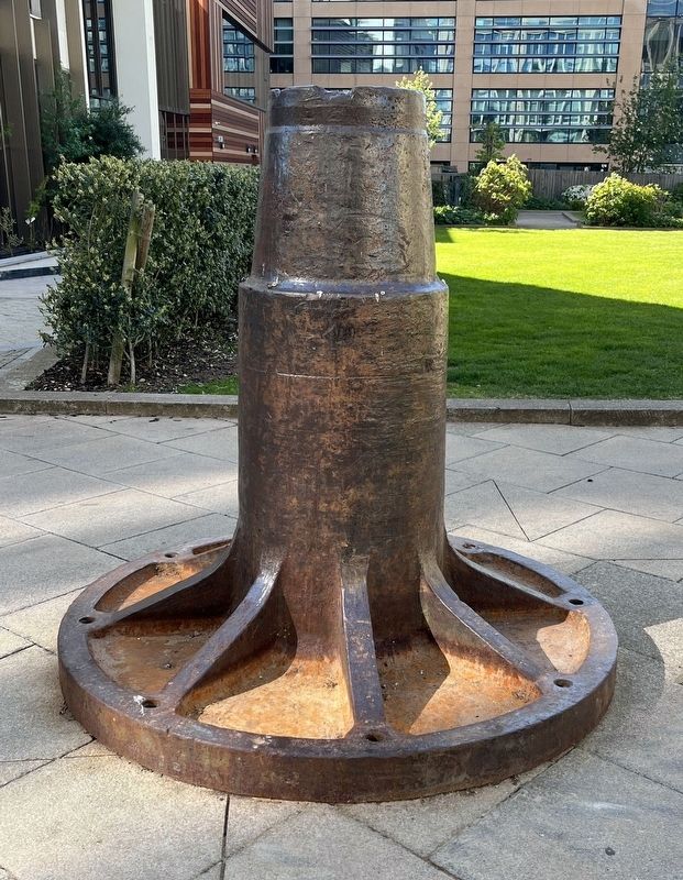
This pivot cone was discovered during the excavation works at CB1 and reinstated here as a piece of Industrial heritage. It was the central balancing and turning mechanism for the historic railway turntable at Cambridge Station, as shown in the . . . — — Map (db m306337) HM
This disk
marks the datum point
from which in 1725 William Warren,
Fellow of Trinity Hall, began to measure
the one mile points along the roads from
Cambridge at which were then set up
the first true milestones in Britain
since Roman . . . — — Map (db m68118) HM
The History of the Cemetery
By the early nineteenth century the churchyards of Cambridge were full and could not be extended in the built-up city centre. The site for Mill Road Cemetery was purchased by public subscription to provide new . . . — — Map (db m246634) HM
Stephen Perse MD
1548 - 1615
Fellow of Gonville & Caius, physician, financier and philanthropist
Founded by his will upon this site the Free Grammar School that later became the Perse Schools — — Map (db m252760) HM
Chippenham Fen
Chippenham Fen covers 117 Ha and is designated as a Site of Special Scientific Interest. The reserve lies in a shallow peat-filled depression underlain by a thick layer of chalky marl which rises to the surface in places. . . . — — Map (db m306331) HM
In the shadow of the cemetery mound lie members of some of Ely's prominent Victorian and early twentieth century families....
The headstones in this part of the cemetery have suffered perhaps more than most from the effects of weathering, . . . — — Map (db m246193) HM
Prior to the cemetery being transferred to the City of Ely Council, some years ago many of the cemetery's headstones were removed from their original positions, broken up and buried. Just why this was done, has become lost in the mists of time. . . . — — Map (db m246194) HM
Great Shelford began as two small settlements. One was clustered around the church. The other included the manor house at Granhams and what is now High Green. The houses of High Green were built round the edge of a large green, which was used as . . . — — Map (db m306332) HM
Over 300 men from Huntingdonshire lost their lives in two World Wars.
There are twenty-eight Commonwealth War Graves in Priory Road Cemetery, of which twenty are the graves of men who died in WW1 and eight graves of men who died in WW2. . . . — — Map (db m316304) HM WM
King Charles spent the night at the George Hotel during the Civil War after Huntingdon was captured by Royalist forces on 24 August 1645 following a brief skirmish.
Whilst staying here Charles wrote a letter to his secretary Edmund Walker at . . . — — Map (db m312588) HM
Huntingdon owes its origins to the High Street at the centre of the town. This was originally part of Ermine Street, a Roman road connecting London to York, later better known as the Great North Road. As the busiest road in England many travellers . . . — — Map (db m316121) HM
Priory Road Cemetery was established in the 1850s and designed by the noted architect Robert Hutchinson, who was later buried here. There are a number of notable people who have been interred here over the last 150 years; these are just some of . . . — — Map (db m316120) HM
Huntingdon was the birthplace and family home of the 17th century soldier and statesman, Oliver Cromwell. You can discover the story 'warts and all' of this very significant and controversial figure at the Cromwell Museum, which houses the world's . . . — — Map (db m312589) HM
Huntingdon was the birthplace and family home of Oliver Cromwell (1599-1658), the 17th century soldier and statesman. Between 1610 and 1616 Cromwell was educated at the local grammar school which was located in this building.
Cromwell lived in . . . — — Map (db m307266) HM
This is a replica of a Russian cannon captured during the Crimean War (1853-56). It commemorates the 31st (Huntingdonshire) Regiment's role in that conflict.
A cannon was captured at the siege of Sebastopol and brought here as a war trophy. It . . . — — Map (db m307264) HM
Oliver Cromwell and eight of his children were baptised in the church which stood on this site until 1651-1660. The parish of St.John Baptist was united with that of All Saints in 1667. — — Map (db m312587) HM
On 21st January 1876 a double collision took place on the Great Northern Railway at Abbots Ripton, 4 miles north of Huntingdon. As a result of the crash, 13 passengers lost their lives and 53 were injured.
Three of the victims of this disaster . . . — — Map (db m312590) HM
The Wale Memorial
On St Margaret's Mount in Newton Road is the Obelisk raised in 1739 by James Church in memory of his friend Gregory Wale.
The two branches of the River Cam
A 'shallow ford' over the river in earlier times gave the . . . — — Map (db m306334) HM
To the memory of James William Nightall G.C., a son of Littleport and a railway man
Locomotive fireman James Nightall was posthumously awarded the George Cross for his heroism in saving the people and town of Soham from death and destruction . . . — — Map (db m306336) HM WM
• Arrival of the Railway. 10th December 1846 Line opened to rail freight.
• The original station was opened on the 14th January 1847. The track was operated by Eastern Counties Railway.
• The route from Ely to Peterborough, originally . . . — — Map (db m313958) HM
March - how the town began
March developed on an island surrounded by marsh. The modern town is derived from two small hamlets, 'Merche' around St Wendreda's Church, and 'Mercheford' by the river. A canal known as 'The Hythe', which ran into . . . — — Map (db m313959) HM
This monument is erected in grateful memory of those men of march who, at the call of king and country, left all that was dear to them. They made the supreme sacrifice that others might live in freedom. Let those that come after see tο it that . . . — — Map (db m313962) WM
This monument is the base of a Late Medieval Stone Cross erected between the years 1470 and 1500 halfway between the settlements of Merche and Mercheford and could have marked the location of a market. Once there was a stone cross built into the . . . — — Map (db m313961) HM
Left Panel:
303rd Bomb Group (H) 8th Air Force
Arrived UK - 12 Sep 42
First Combat Mission 17 Nov 42
Last Combat Mission 25 Apr 45
365 Combat Missions
(The most of any 8AF B-17 Group)
10,721 Sorties - 378 Enemy aircraft . . . — — Map (db m77892) HM WM
Manor House
Immediately south of the Church peeping over the trees and hedgerows is Manor House, built between the 15th and 17th centuries in stone although the house has been extensively altered.
This house has historic connections with . . . — — Map (db m313966) HM
Justly famous for its glorious and lofty spire rising 173 in feet from ground level. The building's massive ashlar faced tower with elegant flying buttresses was built in the 15th century along with the extension to the Chancel. The rest of the . . . — — Map (db m313963) HM
Follow these boards around the historic town of Whittlesey to learn about the interesting buildings and fabulous facts of this 'Fen'tastic place to live, work and visit...
The War Memorial
The War Memorial, funded by the people of . . . — — Map (db m308330) HM
Follow these boards around the historic town of Whittlesey to learn about the interesting buildings and fabulous facts of this 'Fen'tastic place to live, work and visit...
Route Map
This Walk is split into a long route (2.8km 90mins) and . . . — — Map (db m308329) HM
St Mary's Church is a historic Norman cruciform building, notable for having its chancel demolished in 1541.
The central tower features a lower section that dates back to the early 13th century, with the upper part completed in the early 14th . . . — — Map (db m306098) HM
Tempera on canvas applied to wood panel.
Edward Wadsworth spent the First World War in the Royal Naval Volunteer Reserve on the island of Mudros designing dazzle camouflage for allied ships. Post-war he continued to focus on nautical . . . — — Map (db m305261) HM
Cromer Pier Facts
• Records of there being a wooden jetty here date as far back as 1391.
• The Seaside Special, now known as The Cromer Pier Show, was born in 1978.
• Bradley Walsh starred in our famous Cromer Pier Show "Seaside . . . — — Map (db m314532) HM
There is much to see in the town, from North Lodge Park and Happy Valley to the east, the seafront and west cliffs. These panels help illustrate some of the town's heritage, and the museums take the story further.
Cromer Prospect
Cromer . . . — — Map (db m314531) HM
Oil on card
Alfred Wallis was born in Devon and went to sea as a cabin boy at the age of nine, later moving to St Ives where he was a fisherman and rag-and-bone dealer.
He began painting at the age of seventy on pieces of scrap board and . . . — — Map (db m314539) HM
There is much to see in the town, from North Lodge Park and Happy Valley to the east, the seafront and west cliffs. These panels help illustrate some of the town's heritage, and the museums take the story further.
The Gangway
The present . . . — — Map (db m314527) HM
About Portuguese Paving
The pavement represents the Portuguese alliance with England (United Kingdom now). The Treaty of Windsor is the oldest alliance in the world.
The alliance started in 1373 but renowned in 1386 with the Wedding . . . — — Map (db m305659) HM
Great Yarmouth's wealth came from fish, wine and timber. These riches were quickly reflected in the town's buildings. St Nicholas church, for example, was the largest parish church in England when it was completed in 1119. The town's walls were . . . — — Map (db m305660) HM
Great Yarmouth's fishing industry, and its fledgling tourism trade, received a shot in the arm in the 1840s. The arrival of the railways meant that fresh fish landed in the morning could be on sale in the towns and cities of the Midlands and North . . . — — Map (db m305661) HM
About Yarn with Ernie
Ernie Childs was well known in Great Yarmouth. He liked and promoted the town at every opportunity. uniting the themes of maritime, arts, tourism and history. Dressed in Fisherman's smock and cop and leaning on a herring . . . — — Map (db m306370) HM
The Act of Inclosure Map of 1828 shows this land belonging to Anthony Aufrere of Hoveton Hall and Mr. Piggott, a local farmer. It is possible that award was then made to make it public as wherries were not permitted to load at private staithes. . . . — — Map (db m316310) HM
The Pastons were one of Norfolk's most prominent families from about 1380 until 1750. They rose from a rural manor to become successful and prominent lawyers in Tudor England, eventually gaining lands and titles as members of the aristocracy. Today . . . — — Map (db m312648) HM
North Walsham was once the junction of five railways, with lines to Norwich, Aylsham, Cromer, Mundesley and Great Yarmouth. As a result of the commercial competition and a lack of cooperation between the various private railway companies in the late . . . — — Map (db m312657) HM
This two-story brick block dates to around 1700, and has its original attics and cellar. Although the rear dormer is of 19th century date, it is otherwise a very well preserved example of what Timberhill would have looked like in the 18th century. — — Map (db m252915) HM
Though now surrounded by a tower block, a large office complex and a department store, the church remains the focal point of Westlegate and All Saints Green.
What
The Church as it now appears it mainly 14th and 15th century. The tower is . . . — — Map (db m245438) HM
Built in 1549, it was used as the headquarters of the two Royal Armies sent to quell the Ketts Rebellion which took place in that year — — Map (db m250471) HM
This 18th century building, which was originally a warehouse, was bought by the Particular Baptists in 1832 for £1150 and converted into a chapel which was used by them from 1833 to 1975, At the time there were eight Baptist chapels in central . . . — — Map (db m314480) HM
Named after the cattle market which was held to the south of the castle from the 17th century until the 1960s. It was previously known as Common Pump Street, after a pump in the area, and Buff Coat Lane after a public house. — — Map (db m314483) HM
Edith Cavell was the first of four children of the vicar of Swardeston. She worked as a governess in the east of England and Brussels. Aged 30 she returned to care for her sick father and then enrolled as a trainee nurse, wanting to do 'something . . . — — Map (db m250428) HM WM
What
Elm Hill is the loveliest old street in the City, and probably one of the best in the country. It is almost the same in appearance now as it was when most of the properties were last rebuilt, after the major fire of 1507. At that time it . . . — — Map (db m245369) HM
What
Elm Hill is the loveliest old street in the City, and probably one of the best in the country. It is almost the same in appearance now as it was when most of the properties were last rebuilt, after the major fire of 1507. At that time it . . . — — Map (db m252931) HM
In the 14th-15th centuries a house on this site belonged to members of the Paston family, who wrote the famous Paston Letters which chronicle the lives of a wealthy Norfolk family during the Wars of the Roses. After the fire of 1507, the present . . . — — Map (db m250430) HM
Now a private house, the watergate at Pull's Ferry was once home to the ferryman it's named after, John Pull. The arched watergate was built in medieval times, but the adjoining house is newer. It was also known as Sandland's Ferry, after an earlier . . . — — Map (db m312658) HM
Pull's Ferry is named after John Pull ferryman. Built in the reign of Elizabeth is originally named Sandlings Ferry after the is ferryman Sandling.
The Watergate is medieval. The Ferry House c. 1600 with Georgian additions. The building to the . . . — — Map (db m312661) HM
A skeleton discovered during excavations of an 11th century graveyard near this spot has been found to have a mitochondrial DNA marker unique to the Romani people. This is the earliest evidence for a person of Romani descent in the British Isles, . . . — — Map (db m314482) HM
A pre-Conquest church dedicated to St Christopher stood on this site. This dedication is very rare, with only 9 pre-Reformation examples in England. The church burnt down during the reign of Henry III (1216-1272) and the parish was then divided . . . — — Map (db m252918) HM
The name St Peter Hungate preserves an otherwise lost Norwich street name, which may commemorate hounds being kept in kennels in this area.
What
The church as it is now seen is mainly 15th century. The nave and transepts were totally . . . — — Map (db m252930) HM
Formerly the entrance to the house in London Street of John Bassingham, goldsmith during the reign of Henry VIII. It was erected here in 1857. — — Map (db m252917) HM
Originally a Congregational Church the current building, along with the adjoining Church Rooms on Redwell St, was designed by well-known Norwich architect Edward Boardman. He was also responsible, amongst other projects, for converting Norwich . . . — — Map (db m252462) HM
The only remaining example of a residential court leading off Elm Hill, and one of only a handful to survive in Norwich. These courts or yards were a common form of habitation for working people in the City from medieval times until the 1920s, but . . . — — Map (db m252460) HM
Welcome to Wymondham, pronounced 'Win-dum'. The name probably came from a person's name such as Wigmund, with ham meaning village or settlement.
Originally an Anglo-Saxon settlement, it developed into a thriving market town in the Middle Ages. . . . — — Map (db m306389) HM
The King's House was greatly rebuilt in the middle of the 18th century, it has the reputation of being the manor house of Thetford's medieval manorial lords. In the 17th century it was a royal hunting lodge frequented by King James I, whilst he . . . — — Map (db m314588) HM
The Angles Way walking trail between Great Yarmouth and Thetford follows the River Waveney for much of its route. The 93 mile trail passes through the historic and unspoiled landscape of the Norfolk-Suffolk border taking in fantastic scenery, . . . — — Map (db m314582) HM
As well as providing a home to wildlife, this cemetery features many historic graves and a number of interesting, hidden, archaeological features.
St Margaret's Church was originally built before the Norman Conquest, later becoming a chapel to . . . — — Map (db m314601) HM
The Captain Mainwaring statue you see before you was unveiled on 19 June 2010. It marks the long association BBC TV's Dad's Army has had with Thetford -- the real Walmington-on-Sea. The idea for the state was that of Thetford resident, Stuart . . . — — Map (db m306385) HM
Thomas Paine (1737-1809)
Thomas Paine was a radical thinker and one of democracy's biggest champions. His work was hugely influential in both the American and French Revolutions and he earned a reputation as the greatest political figure of . . . — — Map (db m314584) HM
This plaque commemorates the official unveiling of this monument by H.R.H. The Prince of Wales, K.G.K.T., on 29th July 1999.
In 1843 Maharajah Duleep Singh succeeded his father to the throne of the sovereign Sikh kingdom of Punjab. He was . . . — — Map (db m314590) HM
Built in Perpendicular style with later Victorian additions, it is one of only three surviving medieval churches in Thetford. The grave of Sir Richard Fulmerston (died 1586), the founder of the nearby Almshouses and Grammar School, lies in the . . . — — Map (db m314592) HM
One of Thetford's three surviving medieval churches. St. Peter's was extensively rebuilt between 1789 - 1791 by public subscription. Sometimes known as the black church' due to the extensive use of knapped flint, which creates the chequer board . . . — — Map (db m315611) HM
The essential plan of the monastery was established by the founder Roger Bigod.
He laid the foundation stone of the priory on 1st September 1107 just outside the medieval town walls of Thetford on a spacious and level site beside the river. In . . . — — Map (db m314525) HM
The heads of religious houses usually lived apart from the communities they governed.
At Thetford the lodging of the superior or prior of the monastery stood to the west of the church and cloister. Over the course of the Middle Ages the prior's . . . — — Map (db m314524) HM
This was the monastic dining hall where the monks gathered for their meals.
The monks sat at tables on the platforms that run along the sides of the room. At the far end of the interior there would have stood the high table, where the prior his . . . — — Map (db m314523) HM
Thetford Priory was one of the largest and richest religious foundations in medieval East Anglia.
It was a monastery, the home of a community of men called monks living a religious life in the service of God. Founded in 1103-1104 by Roger . . . — — Map (db m306099) HM
The priory church was a large and elaborate building.
Work on the church began in 1107 and the presbytery was probably complete by 1114. The nave, however, was probably not finished for another 60 years.
The church was designed on a . . . — — Map (db m306100) HM
History
Bounded by Downham Road, School Road and Fairfield Lane, the Green was at one time part of the tenancy of The Angel public house. Bit Cameron, landlord for 38 years, kept his donkey here. Historically the field has had many other . . . — — Map (db m316308) HM
'... the hay appeareth and the tender grass sheweth itself and herbs of the mountain are gathered' - Proverbs 27.25
Bay (Laurus nobilis)
Bay was widely used in monastic herb gardens to make sweet-scented, decorative borders. The Strong . . . — — Map (db m314473) HM
Built 1618 to replace a former cross destroyed in the Great Fire of 1615. Formerly the Market Clerk's office this later became the Council chamber and reading room. — — Map (db m314476) HM
Bay (Laurus nobilis)
Bay was widely grown in monastic gardens for its ornamental value and its varied uses. Medicinally, bay leaf tisanes, oils and ointments eased stiff joints, arthritis and rheumatism. Such complaints must have been common . . . — — Map (db m314472) HM
Seeking a fairer society in Norfolk, Robert Kett supported by his brother William, led a rebellion of more than 15,000 people in 1549. The rising was crushed and over 3,000 died. On 7th December 1549 Robert was hanged for treason at Norwich Castle . . . — — Map (db m314475) HM
1. Surviving Parish Church (Wymondham Abbey)
2. Abbey Church
3. Cloister and monastic buildings
4. Outbuildings and gardens
5. Gatehouse
6. Walled Abbey grounds, extending by Lady's Lane
7. Tanneries
8. Mill pool and water mill . . . — — Map (db m314477) HM
There has been a church on this site for over 1000 years.
In 1107, the local Norman landowner established a small community of Benedictine monks here. The church he built was on a grand scale as it served both the monastery and the local parish . . . — — Map (db m306390) HM
This is where people entered the church through the porch. A road once passed close to the door, but was diverted by Rev'd William Papillon in 1826.
The monks' church was at the east end. It was taken down after the monastery closed in 1538, . . . — — Map (db m314467) HM
This is the sunny south side of the church. Some remains of the former monastery buildings still poke through the grass in the meadow behind you.
Be careful not to fall into the ha-ha which was added as a landscape feature in 1834. It separates . . . — — Map (db m314471) HM
This is the great west tower of the church. At 142 ft (42m) high, it is the tallest building for miles around.
The original church had two short Norman towers. They were taken down in 1446 and work started on this new tower to hold the parish . . . — — Map (db m314469) HM
Ahead on your right is the gateway leading through to the church which has been Peterborough's Cathedral since 1541. The first church on this site was founded in 655AD as an abbey, but was then destroyed by the Vikings in 870AD. Its replacement was . . . — — Map (db m307432) HM
The first railway to come through Peterborough was built in 1845 on the line to Northampton with a station which stood south of the river. Peterborough North Station was built on the site in front of you in 1850, for the east coast line.
The . . . — — Map (db m306340) HM
The area across the road used to be the old Cowgate cemetery. Opened in 1803, this was the main graveyard for the city for much of the 19th century. It was notorious in the late 1820s as a haunt of body snatchers; criminals who dug up freshly buried . . . — — Map (db m306338) HM
In medieval times this street was called Hythegate, meaning 'wharf street', as for much of its history the River Nene was navigable. In the 1790s French prisoners of war were landed here to be taken to the world's first prisoner of war camp at . . . — — Map (db m306367) HM
The Quay Planter.
Designed by Stephen Broadbent this wonderful piece of street furniture represents the quay or landing stage Henry Penn used. It was on Bell Dyke near to his bellfoundry. Barges could be loaded with bells he cast and floated . . . — — Map (db m307433) HM
The Peterborough area has a rich heritage for you to discover and explore.
The area has been settled for centuries. 3,500 years ago, Bronze Age inhabitants built a causeway across the marshes at Flag Fen to the east of the city. The Romans . . . — — Map (db m306339) HM
Around 1150 Abbot Martin De Bec created a new market to bring more money into the town and help fund the building of his new abbey church. The result was the 'Marketstede', today Cathedral Square. The monks moved the settlement from Boongate to . . . — — Map (db m307431) HM
For most of its history, this was Narrow Bridge Street, stretching from here to Cathedral Square. It was a narrow medieval street - only 22 feet (6.7 metres) wide. The Town Hall was started in 1929 behind the right hand row of shops and houses, . . . — — Map (db m306363) HM
Peterborough grew rapidly from being a small market town during the second half of the 19th century, thanks to the coming of the railways. By 1861 there were four major rail companies operating in the city, employing 2,000 of the 12,000 population. . . . — — Map (db m307430) HM
In a house on this site lived Simon Gunton (1609-1676), Vicar of Peterborough during the Great Plague, historian and Prebendary of the Cathedral. His book 'The History of the Church of Peterburgh' was published in 1686. — — Map (db m252586) HM
Site of a chapel dedicated to St Thomas Becket murdered in 1170.
It was completed shortly afterwards for pilgrims venerating relics of Becket brought here from Canterbury. — — Map (db m248970) HM
Cowgate gets its name from livestock being driven to market along here in medieval times, particularly as nearby Queen Street was then called 'Butcher's Row'.
The grassed area across the road was covered by the Corn Exchange, built in 1846, . . . — — Map (db m306365) HM
This building, known as The Guildhall, was erected in 1671 to celebrate the restoration of the monarchy in 1660. It became part of Peterborough's council chambers until they were replaced by the present Town Hall in 1933. — — Map (db m252584) HM
The Minster Precincts
The Cathedral Church of St Peter, St Paul and St Andrew gives its name to Peterborough and is the ancient heart of the city. The Minster Precincts cover the site of a great medieval abbey, the remains of which can still . . . — — Map (db m252583) HM
151 entries matched your criteria. The first 100 are listed above. The final 51 ⊳