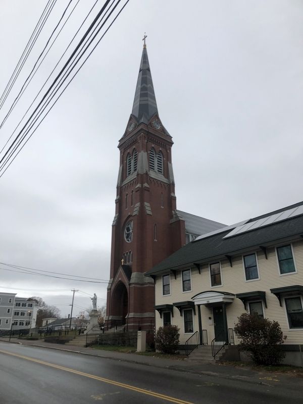
On Elm Street (U.S. 1) at Center Street, on the right when traveling west on Elm Street.
The organization of St. Joseph's Church was begun by Rev. Jean-François Ponsardin, January 5, 1870, under Bishop Bcon's orders to organize a French-Canadian parish in Biddeford. The old Methodist Church on Alfred Street was used from . . . — — Map (db m186185) HM
On St. Mary's Street at Hazel Street on St. Mary's Street.
In 1848, Irish Catholics celebrated their first mass in the Emery House at the foot of Emery Street in Biddeford with Father McGuire of the parish of St. Dominic's in Portland. Around 1850, Catholics started to congregate . . . — — Map (db m186182) HM
On Water Street at Sullivan Street, on the right when traveling west on Water Street.
The Water Street area once had several shipyards. The painting is of the Mt. Washington clipper ship done while in Canton Harbor, China. Built in 1867 at the height of the China trade, the ship was the largest built on the Saco . . . — — Map (db m186152) HM
On Alfred Street (Maine Route 9) at Bacon Street, on the left when traveling south on Alfred Street.
The International Order of Odd Fellows block was built in 1870. Its members alternated with the Masons in laying cornerstones with the Masons in laying cornerstones and dedicating new buildings throughout the city. Fraternal . . . — — Map (db m186161) HM
On Water Street at Main Street ( Route 9), on the left when traveling west on Water Street.
James Sullivan was born in Berwick, Maine in 1744 and came to Biddeford in 1769. Around 1770, he built a two-room house at the corner of Main and Hill Streets and in 1774, his enlarged house became one of the best in the village. He . . . — — Map (db m186153) HM
On Main Street at Laconia Street, on the right when traveling west on Main Street.
The first mill in Biddeford was the Laconia Compny founded by Samuel Batchelder in 1841. Production of cloth began in 1845. Some twelve million bricks were used in the construction. A large machine shop and foundry were constructed . . . — — Map (db m186156) HM
On Main Street at Lincoln Street, on the right when traveling west on Main Street.
The Lincoln Street Mill went into production in 1853. With additions it contained eight million square feet of floor space. Power from the Saco river arrived in 27-foot diameter brick-lined tunnels. Turbines converted the flow into . . . — — Map (db m186164) HM
On Main Street at Lincoln Street, on the left when traveling east on Main Street.
Biddeford, Maine was known for its good theater. It was the second stop on the summer stock route out of Boston. The Opera House shown here is the third on this site. The first was called Beethoven Hall built in 1850 and it could . . . — — Map (db m186179) HM
On Main Street at Elm Street (U.S. 1), on the left when traveling west on Main Street.
The fraternal society, "La Société Saint Jean-Baptiste de Bienfaisance," built its quarters at the corner of Main and Elm Streets in 1895. Organized in Biddeford at the close of the Civil War, July 15, 1867, its founders were . . . — — Map (db m186183) HM
On Main Street at Adams Street, on the left when traveling west on Main Street.
Hotel Thacher was built in 1847 by the Saco Water Power Co. and was originally known as the Biddeford House. It was renamed Hotel Thacher in 1894 in honor of Judge George Thacher. The lines of the block, its roof, and its windows . . . — — Map (db m186166) HM
On Stone Street west of Lincoln Street, on the right when traveling north.
Reverend Tracy of the second Congregational Church and later Pastor of the Second Parish Congregational Church of Saco built this large late Federal style house in 1826. Reverend Tracy came to Biddeford from Cambridge, Massachusetts . . . — — Map (db m186180) HM
On Main Street just west of Franklin Street, on the left when traveling west.
This park is dedicated to Israel Shevenell, (1826-1912) one of the first Franco-American immigrants to Biddeford. Shevenell walked to this town from Canada in 1845. — — Map (db m186163) HM
August 8, 1782, a British ship of 18 guns attacked a small force of inhabitants gathered on Goat Island and was driven away by severe musket fire, losing 17 men. Lieut. James Burnham of this town was killed.
This tablet was erected August 8, . . . — — Map (db m55672) HM
On Mills Road (Maine Route 9) at Main Street ( Route 9), on the right when traveling south on Mills Road.
Memorial to all
Veterans of Kennebunkport
WWII Korean and
Vietnam Conflicts
and to those who
made the
supreme sacrifice
May 30, 1974 — — Map (db m55642) WM
On Depot Street at Summer Street ( Route 9A/35), on the right when traveling north on Depot Street.
This depot was constructed in 1872 when the Boston & Maine Railroad operated a branch line between Portland and South Berwick, Maine. It is an example of Stick-style architecture. During the late 1800, tourists to the area were met . . . — — Map (db m186335) HM
On Main Street (U.S. 1) just south of Elm Street ( Route 9A/35), on the right when traveling south.
This quartet of buildings, which now forms the Brick Store Museum, was operated as separate businesses throughout the decades. The brick building was erected in 1825 by wealthy merchant and ship owner, William Lord. In 1936 Lord's . . . — — Map (db m186324) HM
On Dock Square south of Ocean Avenue, on the right when traveling south.
Over a hundred years ago, it would have been unthinkable to build a bridge that could not open for tall ships. The local economy relied heavily on shipbuilding and the maritime trades.
Many types of bridges have crossed the Kennebunk River . . . — — Map (db m259064) HM
On Kennebunk Plains Trail north of Webber Hill Road ( Route 99), on the right when traveling south.
Humans have lived in fire-adapted ecosystems since time immemorial. The Indigenous Peoples of this region stewarded these habitats with fire before European colonization and continue to use fire on the landscape.
As European settlers arrived, . . . — — Map (db m258615) HM
On Main Street (U.S. 1) at Summer Street (Route 9A/35), on the right when traveling south on Main Street.
This church was built in 1772-1773 on land donated by Colonel Joseph Storer, to house the congregation originally located at the Kennebunk Landing. The church was enlarged by Thomas Eaton in 1803 and the bell tower was constructed. . . . — — Map (db m186323) HM
On Summer Street (Maine Route 9A/35) just west of Durrell's Bridge Road, on the left when traveling west.
The Hugh McCulloch home was actually built in 1787 for Tomas Wiswell. The home ha a massive center chimney and three upstairs bedrooms have hinged walls which can be swung upward and secured to the ceiling to create a large ballroom. . . . — — Map (db m186345) HM
On Main Street (U.S. 1) at Water Street, on the left when traveling west on Main Street.
The Four Way Test
of the things we think, say or do
Is it the truth?
Is it fair to all concerned?
Will it build good will and better friendships?
Will it be beneficial to all concerned?
1925 - Kennebunk Rotary Club is . . . — — Map (db m186303) HM
On Main Street (Route 1) at Water Street, on the left when traveling west on Main Street.
Welcome to Kennebunk
The Native American word “Kennebunk” means “long cut bank” and likely refers to Great Hill at the mouth of the Mousam River which would have been an important landmark to those traveling the coast in their . . . — — Map (db m186306) HM
On Summer Street (Maine Route 9A/35) at Elm Street, on the right when traveling east on Summer Street.
Welcome to Kennebunk
The Native American word “Kennebunk” means “long cut bank” and likely refers to Great Hill at the mouth of the Mousam River which would have been an important landmark to those traveling the coast in their . . . — — Map (db m186327) HM
On Storer Street just north of Berry Court, on the right when traveling north.
Here stood the Lafayette Elm whose image adorns Kennebunk's Town Seal. Named for the great French friend of the American Revolution, the Marquis de Lafayette, who was entertained at the adjoining Storer Mansion on June 25, 1825, the elm and . . . — — Map (db m230975) HM
On Fletcher Street at Intervale Road, on the right when traveling west on Fletcher Street.
In special remembrance of those who gave their lives in the service of their country
Terry F. Drown •
Robert L. Berry •
Thomas W. Bazemore •
Gerald Spofford •
Norman Tremblay •
Ernest H. Wakefield •
Robie K. Wentworth •
Robert E. . . . — — Map (db m267844) WM
On Park Street at Dane Street, on the right when traveling north on Park Street.
The first school to be built on this site was called Union Academy. Built by subscription in 1833 it functioned as a school for those students near the center of town until it was consumed by fire in 1870. The next structure was . . . — — Map (db m186332) HM
On Kennebuck Plains Preserve Trail 0.1 miles north of Webber Hill Road (Route 99), on the right when traveling north.
Kennebunk Plains Wildlife Management Area is over 1,000 acres, including 600 acres of a rare sandplain-grassland community surrounded by a sizable acreage of upland forest. Kennebunk Plains is the first property purchased with Lands for Maine's . . . — — Map (db m258634) HM
On Dock Square south of Ocean Avenue, on the right when traveling south.
Did you know? More wooden sailing vessels were built in Maine in the 19th century than any other state. Two miles upriver at The Landing., entrepreneurs built hundreds of ships between 1760's and 1867. But as demand for giant vessels with greater . . . — — Map (db m258552) HM
On Bourne Street 0.1 miles north of Main Street (U.S. 1), on the left when traveling north.
This three-story federal home was built in 1812 for John Usher Parsons and his bride Susanna Savary. Mr. Parsons died soon after in 1815. The home was then purchased in 1815. The home was then purchased in 1816 by Daniel Sewall, . . . — — Map (db m186318) HM
Near Friendly Pines Lane south of Constitution Road, on the right when traveling east.
More than 20 vessls were built on the Mousm River between the years of 1760 and 1790. Most vessels were built here at what was then "The John Butland Shipyard." The largest vessel weighed nearly 240 tons. Many of the earliest . . . — — Map (db m186348) HM
On Dane Street at Elm Street, on the right when traveling north on Dane Street.
The Dr. Lemuel Richards home was originally built in 1800 for William Taylor who lived here until 1815. After suffering financial losses, due to the War of 1812, Taylor sold the home to William Hackett and Timothy Frost who were . . . — — Map (db m186326) HM
On Summer Street (Maine Route 9A/35) at Sea Road, on the right when traveling east on Summer Street.
This Second Empire style home with mansard roof was built for merchant George Wise in 1868 just three years after the Civil War ended. This home occupies the site which was previously owned by George's father, Captain Daniel Wise, . . . — — Map (db m186338) HM
On Main Street (U.S. 1) just north of Bourne Street, on the left when traveling north.
This Greek Revival home was built by Beniah Littlefield for Horace Porter in 1848. The land was originally owned by Horace’s father, Joseph Porter, who operated a tin shop on the premises. Horace was a wealthy merchant who had this . . . — — Map (db m186319) HM
On Summer Street (Maine Route 9A/35) at Plummer Lane, on the right when traveling east on Summer Street.
This Colonial Saltbox home was built c.1750 making it one of a handful of colonial homes still left standing in Kennebunk. It was built for Captain James Hubbard who was originally from Berwick, Maine. Hubbard commanded of a company . . . — — Map (db m186339) HM
On Main Street (U.S. 1) at Water Street, on the left when traveling west on Main Street.
Numerous manufacturers have occupied this site throughout Kennebunk’s history. Since the first settlement of Kennebunk in the mid 1600s, until now, the Mousam River has been the site of many industries including sawmills, textile and . . . — — Map (db m186307) HM
On Summer Street (Maine Route 9A/35) at Moulton Farm Road, on the right when traveling east on Summer Street.
The depression in the bank across the street is one of the last visible remains of a once thriving shipbuilding industry which existed along the western banks of the Kennebunk River. Prior to 1790, most shipbuilding was done on the . . . — — Map (db m186344) HM
Near Oceanview Road 0.1 miles west of Florence Circle, on the right when traveling west.
Near this spot stood the Larrabee Garrison which was constructed between 1714 - 1722 by William and Stephen Larrabee. It embraced more than an acre of ground and had thick timber walls. Within the walls were five houses. During times . . . — — Map (db m186347) HM
On Water Street just south of York Street (U.S. 1), on the right when traveling south.
It is believed that the Mousam River takes its name from an Indian word, but the true meaning of the word has long been lost. Some speculate that “Mousam” means “Moose”. The face of the river front has changed over the years, as is . . . — — Map (db m186302) HM
On Main Street (U.S. 1) just south of Fletcher Street ( Route 35), on the right when traveling south.
This Federal home was built in 1799 for Nathaniel Frost by Thomas Eaton who was responsible for many residential and commercial buildings in Kennebunk. The original building on this lot was built by Theodore Lyman in 1770 and later . . . — — Map (db m186320) HM
On Main Street (U.S. 1) at Wells Court, on the right when traveling south on Main Street.
This brick building was built by Dr. Frank Ross in 1885 following destructive fires which destroyed the two previous wooden buildings that stood here. This brick building, originally only two stories tall, initially housed Dr. Ross’s . . . — — Map (db m186310) HM
On Storer Street just north of Berry Court, on the right when traveling north. Reported permanently removed.
This home was constructed in 1758 by Joseph Storer and his wife Hannah. Storer was the wealthiest man in Kennebunk at the time and owned a saw mill, country store and grist mill. He entered into the Revolutionary War in 1777. He was . . . — — Map (db m186308) HM
On Summer Street (Route 9A/35) just east of Gilpatrick Shiphard Lane, on the right when traveling east.
Originally this Federal style, brick home was undadorned when built by George Washington Bourne in 1826. The main structure is brick. Following a fire in 1852 which destroyed the original barn, Bourne decided to rebuild it. He added . . . — — Map (db m186343) HM
This magnificent sculpture, designed and executed by Vytautas K. Jonynas, adorned the façade of the Vatican pavilion at the Worlds Fair in New York City (1964-1965). It depicts the church militant, the church suffering, and the church triumphant, . . . — — Map (db m105035) HM
On Storer Street (Route 9A/35) at Portland Road (U.S. 1), on the right when traveling east on Storer Street.
In memory of those who served
World War II • Korea • Vietnam • Lebanon-Granada • Panama • Desert Shield/Storm • Persian Gulf • Afghanistan • Iraq — — Map (db m186331) WM
On York Street (U.S. 1) just north of Swan Street, on the left when traveling north.
This Federal home was designed by Thomas Eaton in 1804 for George W. Wallingford. George Wallingford was born in 1775 and was a graduate of Harvard College in 1795. He was admitted to the bar in 1798 and began practicing law in . . . — — Map (db m186301) HM
On Main Street (U.S. 1) north of Grove Street, on the right when traveling north.
In 2013, long-time Kennebunk resident Geraldine Waterhouse and her granddaughter Paige Hill, bequeathed a generous donation for the purpose of establishing the Waterhouse Youth Endowment at the Waterhouse Center.
This endowment was created . . . — — Map (db m186311) HM
On Main Street (U.S. 1) at Fletcher Street ( Route 35), on the right when traveling south on Main Street.
Kennebunk, her soldiers and sailors of the World War 1914 - 1918
John Authier •
Melvin G Ayer •
Aretas O Barker •
Sidney Batchelder •
Linwood C Bodwell •
Floyd C Boston •
Gail VF Boston •
Deane N Brigham • . . . — — Map (db m186321) WM
On Summer Street (Maine Route 9A/35) at Park Street, on the right when traveling east on Summer Street.
The upper section of Summer Street was settled by wealthy ship builders and business men, many belonging to the Lord and Thompson families. It became known as "Zion's Hill" in 1833 when the sale of liquor was debated by the . . . — — Map (db m186334) HM
On Ocean Avenue, on the right when traveling north.
For our Friend and 41st President
George H.W. Bush
An “Anchor to Windward”
As he was for our nation and world during four years of tumultuous and historic change, so, too, has Kennebunkport served, in the words of St. Paul, “as an . . . — — Map (db m279777) HM
On Dock Square south of Ocean Avenue, on the right when traveling north.
Standing here in 1890, you would have witnessed bustling shipyards with the tap of caulkers, busy wharves, ship chandlers, and a foundry. Both sides of the Kennebunk River offered enterprising shipbuilder a sheltered location, wide banks, and . . . — — Map (db m259188) HM
On Ocean Avenue, on the right when traveling north.
He called Kennebunkport his "anchor to windward" and he loved it. He loved the ocean, whose surf broke against the rocky shore just below his bedroom window. He loved the smell of salt in the sea breeze and the way the moon rose over the lighthouse . . . — — Map (db m279781) HM
On Log Cabin Road, on the right when traveling north.
The founding of the Seashore Trolley Museum on this site in July, 1939, established the private railway preservation movement in the United States. Six young men under the subsequent 50 year leadership of Theodore F. Santarelli de Brasch acquired a . . . — — Map (db m56823) HM
On Beach Street at Shore Road, on the right when traveling east on Beach Street.
David von Schlegell was an Ogunquit resident and a member of the early art colony. After studying engineering at the University of Michigan, and working as an engineer at Douglas Aircraft in Long Beach, California, he served as a pilot in the US . . . — — Map (db m270553) HM
On Stearns Road at Israel Head Road on Stearns Road.
Originally built in 1948 - As the Town had limited funds for this project much of the effort to create this was donated. Designed by Grover S. Perkins Constructed by Winfield C. Littlefield
Renovated in 1993 - The top section was repaired and . . . — — Map (db m246883) HM
Near Stearns Road at Israel Head Road, on the right when traveling north.
"This monument is dedicated to these caring friends who helped restore the Marginal Way after the storm of October 31, 1991."
Mr & Mrs Walter D Abbott •
Anchorage Motor Inn •
Cindy & Dave Barton •
Dr Frank & Etta Block •
Vicki & Dick . . . — — Map (db m266327) HM
To honor
Rear Admiral Robert James White
Chaplain Corps, United States Navy
We erect this tribute to
"Father Bob"
Priest, Chaplain, Lawyer, Educator
with gratitude,
esteem and affection
from the
World War Veterans
July . . . — — Map (db m50328) WM
On 1st Street near Staples Street, on the right when traveling south.
In recognition of these early transatlantic flights from Old Orchard Beach, Maine
and
Harry M. Jones
Pioneer Aviator
whose airport on this beach made these flights possible
August 26, 1927
"Detroiter"
Edward Schlee & William Brock . . . — — Map (db m50263) HM
On Portland Avenue (Maine Route 98) just north of Old Orchard Street (Route 5), on the left when traveling north.
Josephine Goss Home / Harmon Museum
In 1926, Josephine Goss (1840-1937) built this as her home. As the time, she was the last remaining child of Ebenezer and Eliza (Buker) Staples.
The architect for the home was Joseph S. . . . — — Map (db m205776) HM
This monument is dedicated
to the men and women who
served in the Armed Forces
Korean War
June 25, 1950 - Jan. 31, 1955
Vietnam War
Dec. 22, 1961 - May 7, 1975 — — Map (db m50300) WM
On Colby Avenue east of Clover Street, on the left when traveling west.
Opened as the Granite State House by Mrs. I.C. Estes, the hotel was purchased in 1911 by Frank Hale Thurston. Renamed, it was enlarged to include forty-four guest rooms, a bakery, a soda fountain, a barbershop, telegraph and post offices, and two . . . — — Map (db m156357) HM
On Portland Avenue at Imperial Street, on the right when traveling south on Portland Avenue.
The original Staples Inn was erected circa 1730. It was acquired by Elisha Staples in the 1790's. His grandson, Ebenezer C. Staples, opened the farmhouse to visitors circa 1840, and is believed to be the first person in town to take in boarders. . . . — — Map (db m205656) HM
A tribute to the men and women of Old Orchard Beach who served God and Country in World War II and in honored memory of those who gave their lives.
Gideon Abbott • Vincent Calvi
Jeffrey DeGrace • Henry Durant
Richard Freeland • Holroyd Hirst . . . — — Map (db m50301) WM
On Main Street (Route 9) just north of Cutts Avenue, on the right when traveling south. Reported unreadable.
Charles Henry Granter (1812 - 1893) was an artist, musician, poet, translator, historian, outdoorsman and environmentalist. He was born in Saco as the son of Saco Collector of Customs Daniel Granter and Mary Jordan, daughter of Tristam Jordan, . . . — — Map (db m186191) HM
On Main Street (Maine Route 9) near Beach Street, on the right when traveling south. Reported damaged.
Dr. Laura Black Stickney promoted public health, women’s suffrage, and ran for mayor during her 50 years of Saco civic leadership.
Born September 8, 1879 in Porter, Maine, Laura May Black learned to read in a one-room school house, directly . . . — — Map (db m55690) HM
On Beach Street (Maine Route 9) at Main Street, on the right when traveling east on Beach Street.
Cochranism was the name given to the religious sect led by Jacob Cochran in the years 1816 to 1819, before this charismatic preacher was convicted and imprisoned for four years on charges of “gross lewd and lascivious conduct.” The . . . — — Map (db m55698) HM
On Main Street (U.S. 1) 0.1 miles north of Elm Street (U.S. 1), on the right when traveling north. Reported unreadable.
Founded in 1866 as the York Institute, the Saco Museum is one of the oldest museums in Maine. The Institutes mandate was "to promote the study of Natural Hitory; to encourage Science and Art; also to collect and preserve whatever relates to the . . . — — Map (db m186215) HM
On Beach Street (Maine Route 9) at Main Street, on the right when traveling east on Beach Street.
Saco native Samuel Brannan became one of the country’s richest men promoting the California gold rush, and one of the most colorful figures in California history, but he wasn’t a gold miner and he died in poverty.
Brannan was born in Saco in . . . — — Map (db m55699) HM
On Main Street (Maine Route 9), on the left when traveling south.
Sarah Fairfield Hamilton was a founder of the local chapter of the Women's Educational and Industrial Union, and led that organization to create Saco's first kindergarten, a nursery for mill workers' children, summer park programs and other . . . — — Map (db m55721) HM
On Main Street at Beech Street, on the right when traveling south on Main Street.
This plaque is made from bronze taken
from Battleship Maine when salvaged
from Havana harbor in 1912
In Memoriam
U.S.S. Maine
Destroyed in Havana Harbor
February 15th 1898
This tablet is cast from metal
recovered from the U.S.S. . . . — — Map (db m55696) HM
On Main Street (U.S. 1) just north of Elm Street (U.S. 1), on the right when traveling north.
While Saco was served by a number of membership libraries and reading rooms earlier, including that of the York Institute, now the Saco Museum, the City's first truly public library opened in 1882. The library was the creation of Olive and Oliver . . . — — Map (db m186211) HM
On Beach Street at Elm Street (U.S. 1), on the right when traveling west on Beach Street.
In recognition of all the men and women of Saco who have served our country in times of war and peace active and reserve
WWII • Korea • Vietnam • The Gulf War • Iraq • Afghanistan • All other conflicts — — Map (db m186207) WM
On Main Street at Beach Street ( Route 9), on the right when traveling south on Main Street.
At one time, this tiny triangle of land was crowded with buildings: an old house with an adjoining stable that was used as a tavern; another house; a store called the Exchange Coffee House; and another house located on the upper end of the lot. . . . — — Map (db m186196) HM
On Main Street at Beach Street, on the right when traveling south on Main Street.
Erected to the memory of
the Country’s Defenders
1775 – 1865
With malice toward none,
With charity for all,
With firmness in the right,
As God gives us
To see the right — — Map (db m256612) WM
On Main Street at Beech Street, on the right when traveling south on Main Street.
Dedicated to the Glory of God, the Exaltation
of Patriotism, and the Promotion of Education,
in honor of those from Saco
who served in the World War
[Died in Service]
Amede Dupre •
Alfred Durette •
James Gillespie •
Alexander . . . — — Map (db m55697) HM
On Rocky Hill Road north of Heath Road, on the right.
The North Saco Fire Station has served the people of Saco since 1958. This particular station was built in 1975 by the city of Saco, after Jesse Gay donated the land. The original station is located at the corner of Heath and Rocky Hill Roads . . . — — Map (db m245711) HM
On Post Road (U.S. 1), on the left when traveling south.
In memory of the
brave and patriotic Soldiers
of Wells who sacrificed their lives
during the Great Rebellion in
maintaining our Government and
thus establishing on a broader and
firmer foundation the principle of
civil and . . . — — Map (db m55670) WM
Near Skinner Mill Road north of Laudholm Farm Road, on the right when traveling north.
Robert W. Lord imported Guernsey cows from England in 1892. Guernseys were rare in Maine, but produced rich milk and displayed gentle dispositions.
In the early 20th century, this area was a fenced yard for cows. Prospective buyers inspected . . . — — Map (db m186473) HM
Near Skinner Mill Road north of Laudholm Farm Road, on the right when traveling north.
The creamery was used for bottling and canning milk, making cheese, and churning cream into butter. The original creamery was attached to the Maine Coastal Ecology Center in 2001.
Neighbors who stopped by to pick up their milk would mark off . . . — — Map (db m186468) HM
On Skinner Mill Road north of Laudholm Farm Road, on the right when traveling north.
Clark Family
The Clark Farm was the largest and most prosperous farm in 19th-century Wells. Theodore Clark kept a large apple orchard and many sheep on land his family had occupied for generations. In 1820, he renovated his home, creating a . . . — — Map (db m186472) HM
Near Skinner Mill Road north of Laudholm Farm Road, on the right when traveling north.
Built for three teams of horses and to store hay for the winter, the "Big Barn" replaced a similar building that burned in 1902. The Lords built the barn with high quality materials and added technological innovations. These included a hay-wagon . . . — — Map (db m186469) HM
Near Skinner Mill Road north of Laudholm Farm Road, on the right when traveling north.
Farmhands cut blocks of ice from a nearby mill pond, packed them in sawdust, and stored them in this building. Ice was vital for keeping the evening's milk and cream fresh for summer morning deliveries.
Even after automobiles became . . . — — Map (db m186470) HM
Near Skinner Mill Road north of Laudholm Farm Road, on the right when traveling north.
After glaciers retreated from our region 6,000 years ago, Native Americans settling along the coast flourished on its rich resources. When Europeans arrived about 400 years ago and began establishing settlements, they also favored coastal . . . — — Map (db m186467) HM
“….all the life of the planet is interrelated….each species has its own ties to others, and….all are related to the earth. This is the theme of ‘The Sea Around Us’, and the other sea books, and it is also the message of ‘Silent Spring’.”
Rachel . . . — — Map (db m149542) HM
[right front panel]
Rachel Carson National Wildlife Refuge was
created in 1966, to preserve the migrating bird
hubitat and waterfowl migration routes along the
southern coast of Maine. Originally called Coastal
Maine National Wildlife . . . — — Map (db m258547) HM
What Happened?
In May of 2005, a landslide changed the face of the
Rachel Carson Trail near Outlook 1. This singular
event not only altered the appearance of the present landscape, but also changed the surrounding
ecosystem permanently. . . . — — Map (db m258562) HM
Near Skinner Mill Road north of Laudholm Farm Road, on the right when traveling north.
This tower stored water for livestock. It was fed by a hydraulic ram and electric pumps, marvels of technology unusual for a family farm. Water to fill the tank came from the Merriland River near the bridge on today's Skinner Mill Road. . . . — — Map (db m186471) HM
On Post Road (U.S. 1) at Starfish Road, on the right when traveling north on Post Road.
Marking History
Gravestones mark the history of the first English settlers in Wells in this historic neighborhood near the Webhannet River, named by the Abenaki over a thousand years ago. Nearby was the homestead of Edmond and Annis . . . — — Map (db m247513) HM