2008 entries match your criteria. Entries 201 through 300 are listed.⊲ Previous 100 — Next 100 ⊳
Georgia Historical Society Historical Markers
The Georgia Historical Society has administered GA's historical marker program since 1998, erecting hundreds of new markers. GA's historical marker program was begun by the GA Historical Commission in 1953 and continued by the GA Department of Natural Resources. Their markers are now maintained by the Society. With over 3,000 markers, it is 2nd to Texas in state markers.
On Northside Drive West (U.S. 80) near Miller Street, on the right when traveling north.
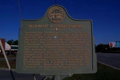
Approaching Statesboro on Dec. 4, 1864, a strong party of mounted foragers from Hazen's division, 15th Corps (USA), on the right of Gen. Sherman's army on its destructive March to the Sea, was attacked by a detachment of Confederate cavalry and . . . — — Map (db m11173) HM
On Courtland Street near North Main Street (U.S. 301), on the left when traveling west.
On Nov. 15, 1864, after destroying Atlanta and cutting his communications to the North, Maj. Gen. W.T. Sherman, USA, began his destructive campaign for Savannah – the March to the Sea. He divided his army (US) into two wings. The Left Wing (14th . . . — — Map (db m9945) HM
On Old Quaker Road (State Highway 24) at Munnerlyn-Alexander Road, on the right when traveling east on Old Quaker Road.
On Dec. 4, 1864, Kilpatrick's cavalry division (USA) of Gen. Sherman's army, supported by two brigades of Baird's infantry division of the 14th Corps, drove units of Wheeler's cavalry corps (CSA) out of Waynesboro and across Brier Creek in order to . . . — — Map (db m7959) HM
On State Highway 56 at Bark Camp Church Road, on the right when traveling south on State Highway 56.
Constituted in the early part of 1788, Bark Camp Baptist Church was a center for culture and hospitality in Bark Camp, one of the oldest settlements in Burke County and a community of wealthy and prominent plantation owners. Among the 29 charter . . . — — Map (db m44549) HM
On Jones Street (Georgia Route 56) at Lee Street (Georgia Highway 17), on the right when traveling north on Jones Street.
On Nov. 15, 1864, after destroying Atlanta and cutting his communications with the North, Maj. Gen. W.T. Sherman, USA, began his destructive Campaign for Savannah - the March to the Sea. He divided his army [US] into two wings. The Left Wing (14th . . . — — Map (db m32534) HM
On Waynesboro Highway (Georgia Route 24), on the left when traveling north.
This highway has been following closely the course of the Old Quaker Road, one of Georgia's earliest vehicular thoroughfares. It was opened about 1769 to link Savannah, the colonial capital, with a Quaker settlement centering around Wrightsboro in . . . — — Map (db m7992) HM
On Pine Street at Burke Street, on the right when traveling north on Pine Street.
On Sept. 28, 1803, a group of men living in Burke County near Beech Branch Meeting House, "found to be in the true Baptist faith", by a presbytery of Rev. Henry Hand and Rev. John Ross, were constituted into one Body as a Baptist Church. A church . . . — — Map (db m18718) HM
Near Porter Carswell Road at Bellevue Plantation Road.
Dating from a royal grant by King George III to Samuel Eastlake in 1767, Bellevue Plantation has been owned continuously by the Carswell family since 1835. The year in which the house was built is not known but it is believed to have been erected . . . — — Map (db m169036) HM
On Botsford Church Road, 0.1 miles east of Cemetery Road, on the right when traveling west.
Botsford Church, Constituted in 1773 by the Rev. Edmund Botsford, was the second Baptist church in Georgia. Originally located 25 miles below Augusta, known as the New Savannah Church, it was moved about 10 miles to this place after the Revolution. . . . — — Map (db m13116) HM
On North Liberty Street (U.S. 25) at Court Street, on the right when traveling north on North Liberty Street.
Burke County, an original county, was created by the Const. of Feb. 5, 1777, from Creek Cession of May 30, 1733. In 1758, it had been organized as the Parish of St. George. Originally, it contained parts of Jefferson, Jenkins and Screven Counties. . . . — — Map (db m7856) HM
On N. Liberty St (U.S. 25) at W. 6th Street (Georgia Route 56/80) on N. Liberty St.
Historic Burke County, formerly St. George`s Parish, claims 8 Ga. Governors by birth, residence or marriage. JOHN HOUSTOUN (1744-1796), Rev. patriot, member of Continental Congress, Gov. 1778-1779 & 1784-1785, was born near present Waynesboro. . . . — — Map (db m7867) HM
On Myrick Street at Williams Street, on the right when traveling north on Myrick Street.
Scotch Presbyterians of St. George's Parish, now Burke County, by 1760 had organized churches at Brier Creek, Old Church (formerly Episcopalian) and Walnut Branch. In 1771 Rev. Josiah Lewis became the first permanent pastor, sent by the Synod of New . . . — — Map (db m40268) HM
On South Liberty Street (State Highway 24) at U.S. 25, on the left when traveling west on South Liberty Street.
The highway bearing left is the Old Quaker road, on of Georgia's earliest vehicular highways. It was opened about 1769 to provide a direct way from Savannah to a Quaker settlement centering around Wrightsboro in today's upper McDuffie County. . . . — — Map (db m8022) HM
On North Liberty Street (U.S. 25) at East 7th Street, on the right when traveling north on North Liberty Street.
Shell Bluff on the Savannah River 15 miles northeast has been famous since Indian days because of its outcrops of fossil shells including those of giant
oysters. These lived in the Eocene sea that covered this part of Georgia some 50 million years . . . — — Map (db m13134) HM
On Georgia Route 24 at Rocky Creek Church Road, on the left when traveling west on State Route 24. Reported missing.
Dec. 2, 1864. Baird's Division, 14th Corps [US], marching on the left of Gen. Sherman’s army in support of Kilpatrick’s cavalry division, which was enroute to burn the bridges over Brier Creek, NE of Waynesboro, reached Rocky Creek about 10:00 A.M. . . . — — Map (db m60505) HM
On South Liberty Street (U.S. 25) at State Highway 24 on South Liberty Street.
Late on Nov. 26, 1864, elements of the 3rd Cavalry Division (USA), Brig. Gen. J.L. Kilpatrick, USA, of Gen. Sherman's army, reached the railroad bridge north of Waynesboro and partially burned it before being driven off by troops of the Cavalry . . . — — Map (db m7903) HM
On North Liberty Street (U.S. 25) near Sixth / Peace Street (Georgia Route 56).
Traveling from Savannah to Augusta on his Southern tour of 1791, President George Washington stopped in Waynesboro on May 17. Departing from Savannah two days earlier, Washington lodged at "one Spencers " in Effingham County, fifteen miles north of . . . — — Map (db m7800) HM
On E. 6th Street at N. Liberty Street, on the right when traveling west on E. 6th Street.
On July 31, 1783, an Act was passed by the General Assembly meeting in Augusta to lay out a town, Waynesborough, on reserved or private land. Commissioners named (Thomas Lewis, Sr., Thomas Lewis, Jr., John Duhart, Edward Telfair, John Jones) were . . . — — Map (db m7868) HM
On Munnerlyn Alexander Road, 0.6 miles east of U.S. 25, on the right when traveling east.
On Dec. 3, 1864, after a hard march across Buckhead, Rocky Beaver Dam and Rosemary creeks from camps N. of Birdsville and W. of Buckhead Church, the 14th Corps [US], Maj. Gen. Jeff. C. Davis, [US] (less Baird's division) camped at Lumpkin's station . . . — — Map (db m13119) HM
On U.S. 23 at Mount Pleasant Church Road, on the left when traveling south on U.S. 23.
On Nov. 17, 1864, Kilpatrick’s cavalry division [US], which was covering the right flank of Gen. Sherman’s army on its March to the Sea, moved from Bear Creek Station (Hampton), 30 mi. NW, down the north bank of Towaliga River to threaten Griffin . . . — — Map (db m39955) HM
On West 3rd Street (U.S. 23) at Oak Street, on the right when traveling west on West 3rd Street.
This County, created by Act of the Legislature December 24, 1825, is named for Capt. Sam Butts killed in the Indian War of 1814 at the Battle of Chalibbee. At Indian Springs, now a State Park, were signed the Treaties with the Creeks giving Georgia . . . — — Map (db m21385) HM
On West 3rd Street (U.S. 23) 0 miles west of Mulberry Street, on the right when traveling west.
On the morning of Nov. 18, 1864, the Right Wing (15th and 17th Corps) of General Sherman’s army [US] moved from its bivouacs in and near Jackson toward Planters’ Factory (Ocmulgee Mills), on the Ocmulgee River at Seven Islands (9 miles SE), to . . . — — Map (db m21370) HM
On Stark Road at Halls Bridge Road, on the right when traveling east on Stark Road.
Robert Grier, astronomer and founder of "Grier’s Almanac", and his family lived about one mile from here and are buried in a family cemetery near the home.
Robert Grier was born in 1780 at his father’s home in Taliaferro Co. He attended Old Union . . . — — Map (db m21337) HM
On Georgia Route 16 at Pratt Smith Road, on the right when traveling east on State Route 16.
On the night of Nov. 17, 1864, the Right Wing (15th and 17th Corps) of General Sherman’s army [US], which had marched south from Atlanta on Nov 15th on its destructive March to the Sea, reached Jackson and camped in and around the town. Hq. Right . . . — — Map (db m26975) HM
On Nov. 17, 1864, the 15th Corps, leading the Right Wing of Gen. Sherman's army (US) on its March to the Sea. marched from McDonough to Jackson. Below Locust Grove (16 mi. NW), Woods' and Hazen's divisions turned right to avoid Jackson and camped . . . — — Map (db m403) HM
On Keys Ferry Road at Winding Way (County Route 293), on the right when traveling east on Keys Ferry Road.
On Nov. 17th, the Right Wing of Gen. Sherman’s army [US] marched from McDonough to Jackson, enroute to Planters’ Factory on Ocmulgee River where it was to cross next day. To relieve congestion on the Jackson road, Smith’s division, 17th Corps with . . . — — Map (db m21327) HM
On West 3rd Street (U.S. 23) 0 miles west of Mulberry Street, on the right when traveling west.
On the night of Nov. 17, 1864, the Right Wing (15th and 17th Corps) of General Sherman’s army [US], which had marched south from Atlanta on Nov. 15th on its destructive March to the Sea, reached Jackson. Hq. Department and Army of the Tennessee (the . . . — — Map (db m21369) HM
On Morgan Road NW at Mayfair Road NW, on the right when traveling west on Morgan Road NW.
Hernando de Soto, born ca. 1500, nobleman, conquistador, Governor of Cuba, with rights to conquer Florida, traveled in 1540 through what later became Georgia on an expedition to find gold. His exact route is unknown and certain landmarks mentioned . . . — — Map (db m27362) HM
On East Main Street (Georgia Route 45) at South Bermuda Street (County Route 153), on the right when traveling west on East Main Street.
This county, created by Act of the Legislature Feb. 20, 1854, is named for John C. Calhoun, famed South Carolina Statesman, who resigned as Vice President of the United States in 1832 to return to the U.S. Senate and defend States Rights in debates . . . — — Map (db m27052) HM
On Charlie Smith Sr. Highway (Georgia Route 40 Spur) 0 miles north of Kings Bay Road, on the left when traveling north.
These are the ruins of a tabby sugar works built by John Houston McIntosh at New Canaan Plantation soon after 1825. In his sugar house McIntosh installed what was, according to Thomas Spalding, the first horizontal cane mill worked by cattle power. . . . — — Map (db m21289) HM
On U.S. 17 at Old Jefferson Highway, on the right when traveling south on U.S. 17.
This road, formerly an Indian trail which paralleled the coast, was used by the Spanish and the British.
In 1778 it was traveled by the Revolutionary soldiers who marched against Fort Tonyn at Point Peter.
Albert Gallatin while U.S. Secretary . . . — — Map (db m81752) HM
On Okefenokee Parkway (Georgia Route 40) 1 mile west of Ga. Hwy 110, on the left when traveling south.
On June 29, 1796, this Treaty was signed ¼ mile south of here near Indian Agent James Seagrove’s home, a trading post and garrison of Federal troops on the St. Marys River. The meeting included representatives of the United States and the State of . . . — — Map (db m60207) HM
On Osborne Street (Georgia Route 40) at Dillingham Street, in the median on Osborne Street.
This town was built on the north bank of the St. Marys River at a place called Buttermilk Bluff. The original tract of land, containing 1620 acres, was purchased by the proprietors for laying out the Town of St. Marys for Jacob Weed for thirty eight . . . — — Map (db m14180) HM
On East Weed Street, 0 miles east of Ready Street, on the right when traveling east.
Grown from pecan nuts found floating at sea by Capt. Samuel F. Flood and planted by his wife, nee Rebecca Grovenstine, on Block 47.
The remainder of these nuts were planted by St. Joseph Sebastian Arnow in the north half of Block 26.
These . . . — — Map (db m14398) HM
On Osborne Street (Georgia Route 40) 0 miles north of West Conyers Street, on the right when traveling south.
Built by public subscription as a place of divine worship for inhabitants of St. Marys and its vicinity. Reverend Horace Southworth Pratt was ordained and installed as the first pastor by the Presbytery of Georgia in June, 1822. Incorporated under . . . — — Map (db m21062) HM
On North River Causeway, 0.1 miles west of New Point Peter Road, on the left when traveling east.
East of here, at the junction of Peter Creek and the St. Marys river, the British built Fort Tonyn in 1776; controlling the southern part of the colony of Georgia for two years. In 1778, American Revolutionary forces, both land and water, forced . . . — — Map (db m81753) HM
On Spinnaker Road at USS Kamehameha Avenue, in the median on Spinnaker Road.
In 1795 a cannon battery constructed on the Point Peter peninsula became the southernmost fortification in the First System of U.S. coastal defenses. Vacated in 1802, it was reoccupied and strengthened in 1808 to provide support for the enforcement . . . — — Map (db m16320) HM
On Conyers Street, 0 miles east of Osborne Street (Georgia Route 40), on the left when traveling east.
This church is the oldest religious organization in the city, although not the oldest church building. George Clark served as the first missionary to the people here in 1792. John Garvin was the first appointed Pastor to St. Marys in 1799. Methodist . . . — — Map (db m23044) HM
On Osborne Street (Georgia Route 40) at Conyers Street, in the median on Osborne Street.
There were originally six wells one in each square, the only source of pure water for St. Marys, (until the tidal wave of 1818).
On the day that the Father of the Country was buried at Mt. Vernon local services were also held throughout the . . . — — Map (db m14178) HM
On Ocean Highway (U.S. 17) at Refuge Road, on the right when traveling south on Ocean Highway.
On the Satilla River 2.8 miles from here, was one of the largest rice plantations in the South. Originally a crown grant of 500 acres to George McIntosh in 1765, it passed to his son, John Houston McIntosh. In 1836 Gen. Duncan Lamont Clinch, U.S. . . . — — Map (db m193231) HM
On Bedell Avenue (Georgia Hwy 25) (U.S. 17) at East 4th Street, on the right when traveling north on Bedell Avenue (Georgia Hwy 25).
Formed from old Colonial parishes: St. Mary and St. Thomas. Camden one of eight original counties of Georgia created by the State Constitution of 1777. County named for Charles Pratt, Earl of Camden, Chief Justice and Lord Chancellor of England. . . . — — Map (db m168000) HM
On West Broad Street (State Highway 46) near Nort Kennedy Street, on the right when traveling west.
Candler County was created by an Act of the Georgia Legislature July 17, 1914, out of portions of Bulloch, Emanuel and Tattnall Counties, and named for Gov. Allen D. Candler (1834-1910). Gov. Candler is famed for the preservation of Colonial and . . . — — Map (db m18229) HM
On Georgia Route 23/121 at Canoochee Road, on the left when traveling south on State Route 23/121.
The route crossing at this point is the Sunbury Road, one of the longest vehicular thoroughfares of post-Revolutionary Georgia. It was laid out in the early 1790's from Greensboro via today's Sparta and Swainsboro to the town of Sunbury, a port on . . . — — Map (db m13361) HM
On City Hall Avenue, 0 miles east of Wood Alley, on the right when traveling east.
Bowdon is near the geographical center of the last land in Georgia owned by the Creek Nation and ceded to the U.S. This tract, approximately 550 sq. mi. in area, is 80 mi long and 10 mi. wide at its widest point.
When Carroll County was . . . — — Map (db m31329) HM
On West College Street (Georgia Route 166) 0 miles west of College View Street, on the right when traveling west.
Bowdon College was Georgia’s fifth chartered institution of higher education and first coeducational institution. Bowdon was a frontier community of merchants and yeomen who nourished the growth of a school where earnest students of limited means . . . — — Map (db m31328) HM
On U.S. 27 at Interstate 20, on the right when traveling north on U.S. 27.
When Georgians B.F. White and E.J. King compiled the songbook, The Sacred Harp, in 1844, they were continuing a singing tradition, which would ultimately become identified with the book. Thousands of southerners would be exposed to music . . . — — Map (db m10036) HM
On Newnan Street (Georgia Route 166) at Dixie Street, on the right when traveling east on Newnan Street.
Carroll County, created by an act of the Georgia legislature in December, 1826, proudly bears the name of Charles Carroll, of Carrollton.
Charles Carroll was born in Annapolis, Maryland, in 1737. He attended preparatory schools in this country . . . — — Map (db m12872) HM
On Newnan Street (Georgia Route 166) east of South Tanner Street, on the right when traveling east.
Born within a few miles of each other were six people who are recognized as giants of industry in the southeast. Asa G. Candler of Villa Rica was founder and first president of Coca-Cola; Sam Candler Dobbs, president of Coca-Cola; Arthur Acklen, . . . — — Map (db m61023) HM
On West Bankhead Highway (Georgia Route 78) at South Dogwood Drive, on the left when traveling west on West Bankhead Highway.
Thomas Andrew Dorsey, composer of over 400 blues and gospel songs, lived here following his birth in Villa Rica on July 1, 1899. At Mt. Prospect Baptist Church he was exposed to shape-note singing and at home learned to play a used pump organ, . . . — — Map (db m10043) HM
On Bankhead Highway (U.S. 78) at South Candler Street, on the left when traveling west on Bankhead Highway.
Around 11:00 a.m. on December 5, 1957, a natural gas leak under Berry’s Pharmacy caused an explosion that destroyed four buildings and damaged several others in Villa Rica’s downtown. The explosion killed twelve and injured twenty. The tragedy . . . — — Map (db m10044) HM
On West McIntosh Circle, 2 miles south of Georgia Route 5, on the left when traveling south.
William McIntosh, Scotch-Coweta Chief of the Coweta Towns, distinguished soldier in the battle of Autossee and Horseshoe Bend, and in the Seminole Wars with the rank of Brigadier-General, was killed by Upper Creeks and is buried here, the site of . . . — — Map (db m12548) HM
On Old Dixie Highway (U.S. 41) 0.2 miles north of Haggard Road, on the right when traveling north.
For the last eight miles this highway has followed closely the course of the Old Federal Road northeast Georgia’s earliest vehicular thoroughfare and first postal route. It led this way from the southeast Cherokee boundry, in the direction of . . . — — Map (db m12173) HM
On Tunnel Hill Road at Catoosa Parkway (Georgia Route 2), on the left when traveling south on Tunnel Hill Road.
May 7, 1864. The 4th A.C., marching from Catoosa Springs, moved S. on this road to Tunnel Hill - Stanley’s div. in advance, followed by Wood & Newton;
Maj. Gen. O.O. Howard, commanding. The march was opposed by outposts of Wheeler’s cav. - the . . . — — Map (db m13609) HM
On Lafayette Street at Tennessee Street, on the right when traveling north on Lafayette Street.
Nine miles west of here on Saturday and Sunday, September 19th and 20th, 1863, the bloody battle of Chickamauga was fought. Here, Federal forces of about 60,000 under Major-General William S. Rosecrans, U.S.A., fought the two day battle with . . . — — Map (db m19249) HM
On Catoosa Parkway (Georgia Route 2) at Tunnel Hill Road, on the right when traveling east on Catoosa Parkway.
The 4th A.C., marching from Cleveland, Tenn. reached Catoosa Springs May 4, 1864. The 23d A.C., via Cleveland & Red Clay, camped in this vicinity. Both corps moved S. from these positions toward Dalton, May 7. The 4th A.C. went by direct rd. to . . . — — Map (db m13611) HM
On Nashville Street (U.S. 41) 0 miles west of Jail Street, on the left when traveling west.
Created December 5, 1853, the county has an Indian name. Ringgold bears the name of Major Samuel Ringgold, who died of wounds received at the Mexican War battle of Palo Alto in 1846. Taylor’s Ridge, visible for miles, is named for the Indian chief . . . — — Map (db m19268) HM
On Keith Road (County Route 1286) 0.6 miles north of Catoosa Parkway (Georgia Route 2), on the left when traveling north.
In 1862-1863 several Confederate hospitals were located here. The sick and wounded Confederate soldiers drank of the health-giving waters of the several mineral springs in this area. Drinking this mineral water and bathing in it enable many sick . . . — — Map (db m13610) HM
On Nashville Street (U.S. 41) 0 miles north of Jail Street, on the left when traveling north.
Here in 1862-1863 were located several Confederate hospitals - The Foard, The General, The Bragg, and The Buckner. The Courthouse, Napier's Hotel, two
Churches, several warehouses, and temporary buildings were also used as hospitals. More than . . . — — Map (db m12196) HM
On Alabama Highway (Georgia Route 151) at East Nickajack Road, on the left when traveling south on Alabama Highway.
The road E. ascends Taylor’s Ridge & via Nickajack Gap, crosses E. Chickamauga Cr. Valley. May 7, 1864. Brig. Gen. Judson Kilpatrick’s (3d) Div., Elliott’s Cav. Corps (Army of the Cumberland) [US], moving from Ringgold, crossed Taylor’s Ridge at . . . — — Map (db m19394) HM
On Catoosa Parkway (Georgia Route 2) at Chattanooga Road (U.S. 41), on the right when traveling east on Catoosa Parkway.
This highway is part of the Old Federal Road, an early thoroughfare that linked Georgia and west Tennessee across the Indian Country. It began on the southeast boundary of the Cherokees, in the direction of Athens, Georgia and led toward Nashville . . . — — Map (db m207195) HM
On Catoosa Parkway (Georgia Route 2) at U.S. 41, on the right when traveling east on Catoosa Parkway.
This Church, organized September 2, 1837, before the Cherokee Indians were removed from this area, was the first church organized by white settlers in the bounds of the present Catoosa County, according to available records. The organizers were a . . . — — Map (db m207192) HM
On Nashville Street (U.S. 41) 0.3 miles south of Peters Lane, on the left when traveling north.
After the battle of Missionary Ridge, Bragg's Confederate Army retreated in disorder towards Dalton. Brig. Gen. Patrick R. Cleburne was ordered to take position in the gap, hold back the Federals, and save the trains and artillery from capture. . . . — — Map (db m12181) HM
On Burning Bush Road, 0.3 miles north of Red Belt Road / Three Notch Road, on the right when traveling north.
Thomas Thompson Napier built this house in 1836 of heavy local timber prepared by slaves and finishing lumber brought by ox-wagon from Augusta. During the Battle of Chickamauga 20 wounded soldiers were cared for in the house by Mrs. Martha Harris . . . — — Map (db m13864) HM
On Tennessee Street (Georgia Route 151) at High Street, on the left when traveling north on Tennessee Street.
This house of handmade brick was built about 1863 by Mr. William L. Whitman, prominent merchant of Ringgold. After the Battle of Ringgold General U. S. Grant established his headquarters here. When he and his staff were leaving he offered Mrs. . . . — — Map (db m9061) HM
On Nashville Street (U.S. 41) at Depot Street, on the right when traveling north on Nashville Street.
This is the only depot between Atlanta and Chattanooga that has been in continuous use since May 9, 1850, when the first train ran over this end of the line. Previous to the coming of the W & A to 'Cherokee Georgia,' the nearest market was Augusta, . . . — — Map (db m9207) HM
On E. Love St. at US1/ US301 ( N. 2nd St ), on the left when traveling east on E. Love St..
Two miles Northeast of here is the site of old Center Village, or Centerville, settled about 1800 and for many years an important trading center. To this village came the inhabitants of Ware, Pierce, Clinch, Coffee and Appling Counties, bringing . . . — — Map (db m12993) HM
On Main Street at South 3rd Street, in the median on Main Street.
Created by an Act of February 18, 1854 out of Camden County, Charlton County was named for Judge Robert M. Charlton of Savannah. Trader's Hill (Fort Alert), an important shipping point and head of navigation on St. Marys River, was the first County . . . — — Map (db m12951) HM
Traders Hill Masonic Lodge was established by dispensation March 1, 1854, one month after Charlton County was created. The first return to the Grand Lodge was made in 1855, and showed: the Rev. F.M. Smith, W.M.; R.A. Baker, S.W.; P.W.W. Mattox, . . . — — Map (db m14477) HM
On Okefenokee Parkway (Georgia Route 23) at West Main Street, on the right when traveling south on Okefenokee Parkway.
Okefenokee, “Land of the Trembling Earth”, was a favorite hunting and fishing ground for many tribes of Indians. General Charles Floyd with 250 dragoons drove out the last of these, the Seminoles, in 1838 ending Indian rebellion in . . . — — Map (db m27477) HM
On Georgia Route 121, on the left when traveling south on State Route 121.
This mill pond marks the site of Major Archibald Clark's sawmill, the oldest industry in what is now Charlton County. Built about 1802, this mill with upright saws was operated by water power, and lumber shipped down the St. Marys River.
Major . . . — — Map (db m14476) HM
On Jacksonville Highway (U.S. 1) 1.3 miles south of Georgia Route 121, in the median.
Racepond was named for “Race Pond,” a round cypress pond near here, where, about 1836, United States soldiers ran their horses for sport.
The troops were stationed at the pond to watch for and capture any Indians who might venture . . . — — Map (db m53021) HM
On Okefenokee Parkway (Georgia Route 23) at Spanish Creek Road (County Route 45), on the right when traveling south on Okefenokee Parkway.
Sardis Church, about 2 miles West on this Road, is the oldest church in Charlton County. Constituted some time before 1821, the first edifice was built in this area. The church was moved to or near its present site in 1840. The pulpit in this . . . — — Map (db m27439) HM
On Okefenokee Parkway (Georgia Route 121) at the road to Traders Hill, on the right when traveling north on Okefenokee Parkway.
About 2 miles East, on this road, is the site of "Fort Alert, usually called Trader's Hill." Established in the 18th century, and defended by a stockade garrisoned by U.S. Troops, Trader's Hill was a refuge for settlers during the Indian Wars. At . . . — — Map (db m14472) HM
On Georgia Route 94, 0.1 miles west of Georgia Route 185, on the left when traveling east.
Ellicott’s Mound, 5 miles north, at the head of the St. Marys River, was erected February 27, 1800, to mark the boundry between the United States and Spanish Florida, as set fourth in the Treaty of 1795 with Spain. Major Andrew Ellicott noted . . . — — Map (db m9186) HM
On Fort Argyle Road (Georgia Route 204) at Bush Road, on the left when traveling east on Fort Argyle Road.
Chartered in 1824, the Savannah-Ogeechee Canal was constructed between 1826 and 1830 by African and Irish laborers who moved thousands of cubic yards of earth. A boon to Georgia’s economy, the canal moved cotton, rice, bricks, and natural . . . — — Map (db m47921) HM
On Fort Argyle Road (State Highway 204) at Bush Drive, on the left when traveling west on Fort Argyle Road.
On Dec. 6 1864, the 15th Corps [US], Maj. Gen. P. J. Osterhaus, USA, the extreme right of Gen. Sherman's army on its destructive March to the Sea, forced a crossing of Great Ogeechee River at Jenk's Bridge (US 80 east of Blitchton) and drove the . . . — — Map (db m12080) HM
On Parkersburg Road south of Holcomb Street, on the right when traveling west.
The Isle of Hope Methodist Church was organized in 1851. The first Trustees were George W. Wylly, Simeon F. Murphy, John B. Hogg, William Waite, Theodore Goodwin, Thomas J. Barnsley and the Rev. William S. Baker.
The church building that stands . . . — — Map (db m15947) HM
Near Islands Expressway (U.S. 80), on the left when traveling east.
Built by Federal troops during the Civil War, in February 1862, Battery Hamilton prevented Confederate gunboats and reinforcements from moving down the Savannah River to aid the besieged Fort Pulaski. Its presence also allowed the Federals to . . . — — Map (db m55178) HM
On Augusta Road (State Highway 21/30) north of Drakie Road, on the right when traveling north.
Mulberry Grove which is located approximately 2 miles northeast from this marker is one of the most historic of the old Savannah River plantations.
In early Colonial days mulberry trees were cultivated at Mulberry Grove for use in Georgia's . . . — — Map (db m8064) HM
On Augusta Road (State Highway 21/30) north of Drakie Road, on the right when traveling north.
Near here stood Mulberry Grove, plantation home of General Nathanael Greene and Catherine Littlefield Greene. President George Washington twice visited the widowed Mrs. Greene at Mulberry Grove during the Southern tour of 1791. Traveling downriver . . . — — Map (db m18640) HM
On Shipyard Road, 0.2 miles east of Ferguson Road, on the right when traveling west.
Approximately 300 yards northeast of this marker there was located in colonial days a shipyard where at least one vessel capable of engaging in overseas trade was built. The creek on which it stood is known as Shipyard Creek. The site of the . . . — — Map (db m9399) HM
On U.S. 80 near Rogers Street, on the left when traveling west.
On Dec. 9, 1864, troops of Mower's division, 17th Corps, of Gen. Sherman's army (U.S.) , which was closing in on Savannah, advanced to Pooler after suffering losses through the day from artillery mounted on a RR flat car, torpedoes planted on the . . . — — Map (db m10630) HM
On South Coastal Highway (State Highway 25) near Oxnard Drive, on the right when traveling north.
In December, 1864, was fought on the Savannah River near here one of the few battles in which Confederate gunboats and Union field artillery were engaged against each other. Colerain Plantation, as these lands were then known, had been occupied on . . . — — Map (db m12615) HM
Near Main Street (Georgia Route 25) north of Bourne Avenue (Georgia Route 307), on the right when traveling north.
The Georgia Ports Authority (GPA) was created in 1945 by the state during the economic boom of World War II. Savannah and Brunswick, Georgia's deepwater ports, had a long history of global trade. The GPA owns two Savannah terminals: its headquarters . . . — — Map (db m200203) HM
On Augusta Road (State Highway 21) at Old Augusta Road (Old State Highway 21), on the right when traveling west on Augusta Road.
Houston Baptist Church and its adjoining cemetery were
organized in 1886 under the leadership of Reverend Ulysses L. Houston, minister of First Bryan Baptist Church in Savannah. A significant religious and political leader in the African-American . . . — — Map (db m7962) HM
On South Coastal Highway (State Highway 25) near Oxnard Drive.
During the first years after the founding of the Colony of Georgia in 1733 these lands (now owned by the Savannah Sugar Refining Company) were known as the "Grange" or "Cowpen" plantation. Along the Savannah River, about one mile East of this . . . — — Map (db m159595) HM
On State Highway 21, on the right when traveling south.
Richmond Baptist Church and its adjoining cemetery were organized on March 14, 1897 under the leadership of Rev. E.K. Love, third pastor of First African Baptist Church in Savannah. Rev. Love was a significant missionary and religious leader in the . . . — — Map (db m53372) HM
Near Woodcock Street/Fort Jackson Road, 1.2 miles north of East President Street, on the right when traveling north.
Fearful of U.S. invasion during the Civil War, two Macon women prompted a statewide campaign to build an ironclad vessel for the protection of Georgia's coastal and riverside towns. By March 1862, the Ladies Gunboat Association had formed to raise . . . — — Map (db m133215) HM
Near Gulfstream Road, 0.3 miles west of Robert B. Miller Road, on the left when traveling west.
Here, on Sept. 29, 1967, Gulfstream Aerospace Corp. established its Savannah facility, now its headquarters. The world's first purpose-built business aircraft company was born from Grumman Aircraft Engineering Company after World War II as the . . . — — Map (db m200202) HM
On Ocean Highway (Route 17) at Basin Road on Ocean Highway.
Dec. 1864. After a 300 mile march which had left a wide belt of destruction from "Atlanta to the Sea," Gen. Sherman's army (USA) of about 60,000 men was nearing Savannah. During he first weeks of his campaign, his four widely-spread columns had . . . — — Map (db m9115) HM
On LaRoche Avenue near Majestic Oaks Drive, on the left when traveling south.
In 1910 and 1911 the Mercer Automobile Company of Trenton, New Jersey made entries in the Great Savannah races. Washington Roebling II , the only company owner who drove in the races, and driver Hughie Hughes led teams in several light car and grand . . . — — Map (db m5976) HM
This 1½ mile oak avenue leads to the tabby ruins of Noble Jones’ colonial fortified plantation. Jones and his family were original settlers in Georgia, arriving in Savannah with founder James E. Oglethorpe on February 1, 1733. As a middle-class . . . — — Map (db m10960) HM
On Lehigh Avenue at Pin Point Avenue, on the left when traveling south on Lehigh Avenue.
Pin Point was settled in 1896 by former slaves from Ossabaw, Green, and Skidaway Islands. Sweetfield of Eden Baptist Church, founded in Pin Point in 1897, was a successor to Ossabaw’s Hinder Me Not Church and also served as the community's school . . . — — Map (db m54183) HM
On College Avenue at Vernon Street, on the right when traveling north on College Avenue.
This state college was established in 1891 as the Georgia Industrial College for Colored Youths as an outgrowth of the Second Morrill Act of 1890 and an Act of the Georgia General Assembly, November 26, 1890, creating this institution as one of the . . . — — Map (db m21059) HM
On Chatham Parkway, on the right when traveling south.
Beginning on December 10, 1864, Union and Confederate soldiers fought near here at Shaw’s Bridge and Shaw’s Dam, as Union General William T. Sherman’s army moved toward Savannah. During bloody fighting, Confederates twice repulsed Union attempts to . . . — — Map (db m4949) HM
On Felix J. Alexis Circle, 0.1 miles east of South Tompkins Road, on the right.
This is the oldest remaining building on the Savannah State University campus. It was constructed in 1901 by the students and faculty of then Georgia State Industrial College during the administration of the college’s first president, Richard R. . . . — — Map (db m21220) HM
On Skidaway Road near Montgomery Cross Road, on the right when traveling north.
Established by African Americans in the nineteenth century, Sandfly is centered around the intersection of Montgomery Crossroad and Skidaway Road. Many families in this community trace their ancestry to former slaves from nearby Wormsloe . . . — — Map (db m89794) HM
On East Broad Street near East Gordon Lane, on the right when traveling south.
In May 1874 two Benedictine priests arrived
in Savannah to work with the city's African-
American community, and constructed a
church four blocks north of here. In 1889
a new building was constructed at this site.
The Society of African . . . — — Map (db m15721) HM
On East Montgomery Crossroad (Georgia Route 204), on the right when traveling east.
Named for respected Methodist Bishop Gilbert Haven of Massachusetts, Haven Home School was established in 1885 with the support of the Women’s Home Missionary Society, to provide local African-American girls with a quality education. In 1917, after . . . — — Map (db m34670) HM
"This is no time to talk of moderation; in the
present instance it ceases to be a virtue."
Speech to Provincial Congress, June 5, 1776 Foremost among Georgia's Revolutionary patriots stood Archibald Bulloch whose remains rest in this . . . — — Map (db m5335) HM
2008 entries matched your criteria. Entries 201 through 300 are listed above. ⊲ Previous 100 — Next 100 ⊳