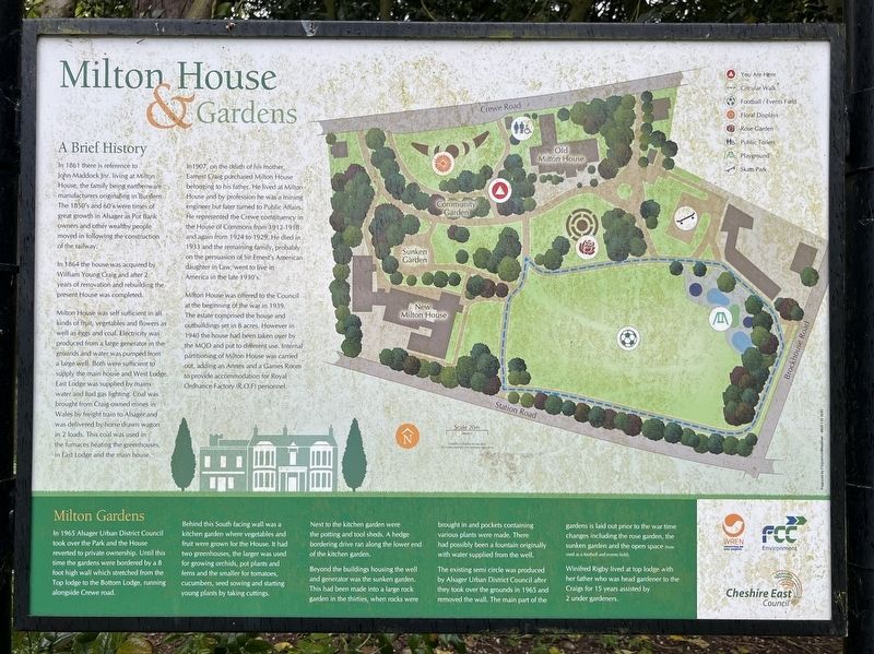
A Brief History
In 1861 there is reference to John Maddock Joy, living at Milton House, the family being earthenware manufacturers originating in Burslem. The 1850's and 60's were great growth in Alsager as Pot Bank owner and other wealthy . . . — — Map (db m308231) HM
Crewe is a railway heavyweight. Over 8,000 locomotives were built here. In the 1930s, Crewe Works was said to be the largest engineering works in the world. Its site was 2 miles across and employed over 7,000 people.
You are stood on the edge . . . — — Map (db m308327) HM
The fuel storage facility at Twemlow was commissioned as part of the Government Pipelines and Storage System (GSS). This system first developed prior to WWI, was strategically important to keeping Britain's airports supplied with fuel during . . . — — Map (db m308247) HM
1. The buildings on the west side of The Square are nearly all 19th century. Many retain their original shop frontages and are therefore within the Conservation Area. The passages now lead to car parks rather than yards and gardens. The entrance to . . . — — Map (db m308233) HM
In the days before dating apps, Sunday night was date night on Mill Street in Macclesfield. The street was once well known as the place where young local people used to gather. On a Sunday evening after tea, when there was nothing else to do, they . . . — — Map (db m308328) HM
St Mary's Church is a truly magnificent building inside and out.
With its distinctive octagonal tower it is a landmark visible on all routes into Nantwich. Built of red sandstone in the 14th century it is situated at the heart of this . . . — — Map (db m252457) HM
You are standing on Newgate, one of the most recent gateways into the city centre.
The earliest medieval gateway here was called Wolfeld's Gate, and was first recorded in the late 12th century. The original gateway may have dated to before . . . — — Map (db m250502) HM
The main bathing halls comprised three rooms: the cold room (frigidarium), warm room (tepidarium) and hot room (caldarium). The frigidarium and caldarium had plunge baths supplied with cold and hot water. The tepidarium, caldarium and sudatoria . . . — — Map (db m246536) HM
The baths were one of the most impressive buildings of the Chester fortress. Roman baths were the leisure centres of their day, and offered a place to relax or exercise as well as bathe.
The baths lay on the east side of Bridge Street and . . . — — Map (db m246535) HM
"Here is a noble stone bridge over the Dee. Very high and strong built, and 'tis needful it should be so, indeed: for the Dee is a most furious stream at some seasons, and brings a vast weight of water with it from the mountains of Wales."
-- . . . — — Map (db m253193) HM
Land was the major source of wealth in the Roman world, and art in the houses of the rich celebrated the source of their income.
This replica mosaic, sponsored by the Chester Civic Trust, commemorates Roman gardens and includes scenes from . . . — — Map (db m246573) HM
"A noble and stately building having a lower bearing the name of Julius Caesar and a goodly hall where the Palatine Court and Assizes are kept twice a year."
Chester Castle was once a great stone fortress and the seat of power in the . . . — — Map (db m253200) HM
"... we admire the monks of Chester because they are not wearied by the toil of their joyful yoke. To the local people-they are cheery, to those who come from afar they are jovial, ready to open their hearts to them."
- Moni Lucian of Chester 1200 . . . — — Map (db m250065) HM
For 2,000 years East Gate has been the main entrance into the historic walled city of Chester.
Looking at East Gate today, in all its Georgian delicacy, it is difficult to imagine this as the main gateway to Deva - one of the most important . . . — — Map (db m250051) HM
These ruins are all that survive of the Norman choir and medieval chapels which once formed the east end of St John's Church. In the Middle Ages the church was twice the length it is today.
In the mid-century, England broke away from the . . . — — Map (db m245668) HM
From Tudor times this was a wealthy area and one of the most fashionable parts of Chester.
Following Henry VIII's destruction of the monasteries, the outbuildings of St John's church became homes for the local gentry. In the 18th century a . . . — — Map (db m250499) HM
Four very different landmarks each with their own unique history, there are also wonderful views across the River Dee from the Belvedere. There are more heritage features just a short walk away in the 'Quarry Garden' area of the park.
1. . . . — — Map (db m250500) HM
This historic lookout and meeting place is one of the most iconic towers on the City Walls.
The King Charles Tower was once a medieval watch-tower, but by the 17th century had fallen into disrepair. Not enough 'murage' tax was being raised for . . . — — Map (db m246621) HM
This was the view through the tall arch to the east end of St. John's in the late 18th century. At that time the ground level within this chapel was much higher than it is now.
Great mounds of soil and rubble were removed in 1871, when
the . . . — — Map (db m253698) HM
Chester's medieval North Gate was both a defensive gateway and the city gaol, protecting the city from threats within and without.
This artist's impression shows a prisoner in around 1790 walking over the 'Bridge of Sighs' to receive his last . . . — — Map (db m246619) HM
This is the base of the great North West Tower of St. John's which collapsed in 1881. Originally, it was nearly three times as high and was a major local landmark.
The Norman church was planned in a cruciform shape with a central tower and two . . . — — Map (db m253437) HM
This was the home of Randle Holme I, Mayor of Chester 1633-4. It was described as a "new building" in 1633. Four generations of the Holme family worked as Chester Heralds and Historians during the 17th century. Their painted heraldic memorial . . . — — Map (db m216254) HM
The first Duke of Westminster (1825-1899) commissioned Parker's Buildings in 1889 as part of his programme of improving housing for the poor. The building was designed by the Cheshire architect, John Douglas (1830-1911) who also designed many other . . . — — Map (db m250059) HM
Originally named Bull Mansion, this was the residence of Chester's Recorder in 1533. It was refronted in the 18th century when it became an important coaching inn. George Borrow is thought to have stayed here during his tour of "Wild Wales" in . . . — — Map (db m216196) HM
The Red Lion is situated on Northgate street, a road that is steeped in over 2000 years of history. In the year 79, Chester was founded as a Roman fort under the name 'Deva Victrix', Chester's four main roads, Eastgate, Northgate, Watergate and . . . — — Map (db m230600) HM
The Romans built amphitheatres in their main centres of power. As a legionary fortress, archaeologists expected there to be one at Deva (Chester), but no remains had been found. Then, by chance, workmen unearthed a piece of curved wall in 1929, and . . . — — Map (db m246438) HM
The gardens were first laid out in 1949 to display the many Roman building fragments that had been discovered in Chester during the previous century.
None of the fragments originate from this site. Many
of them come from the site of the . . . — — Map (db m246572) HM
In front, is the ancient choir of St. John's Church, cut off from the rest of the chancel when the east wall was built in 1581. Here, services were sung and celebrated for 450 years.
In the Middle Ages the Choir was just as impressive as the . . . — — Map (db m245670) HM
This is is one of two medieval side chapels built on either side of the Lady Chapel. It replaced a Norman chapel which was probably semi-circular. This is the most complete part of the ruins and the walls survive almost to their full height.
This . . . — — Map (db m245669) HM
This medieval building is usually described as the "Chapter House". The upper storeys have gone, but a stone vaulted undercroft survives. It dates from the late 12th century when St. John's was an important Collegiate church. The Chapter House may . . . — — Map (db m253697) HM
Chester's oldest church this has been a site of christian worship for nearly thirteen centuries & the present building has stood for more than 900 years.
This view of St Johns shows the full extent of the church
in the early 19th century. Many . . . — — Map (db m253699) HM
Chester's oldest church this has been a site of christian worship for nearly thirteen centuries and the present building has stood for more than 900 years.
Throughout its long history, the ancient church of St. John's has undergone many . . . — — Map (db m253723) HM
The construction of amphitheatres ('double theatres') began in southern Italy and followed the spread of Roman rule. Chester's amphitheatre is the biggest known in Britain. It could seat around 7,000 spectators and would have been a powerful symbol . . . — — Map (db m246439) HM
No matter whether they were interred or cremated, in the Roman world the socially mobile wanted to display their wealth and status in the elaboration and siting of their tombs.
From the rest is the laws of Rome forbade within the formal . . . — — Map (db m246618) HM
The Rows could be described as the oldest shopping arcade in Britain. They were built between about 1200 and 1350, when Chester was a booming market town and port. This has been bustling heart of the city ever since, where people have come to . . . — — Map (db m294391) HM
Thomas Brassey constructed railways, bridges, tunnels, stations and locomotives as well as harbours and London's sewers. At the height of his career he employed more than 80,000 men worldwide.
Brassey was born in 1805 in the parish of Aldford . . . — — Map (db m245671) HM
Born: Buerton by Chester
Engineer
'the most important civil engineering contractor in the world during the nineteenth century'
Built some 2061 miles of railway in Britain and 4462 miles overseas plus other major construction contracts . . . — — Map (db m253117) HM
The gardens were first laid out in 1949 to display the many Roman building fragments that had been discovered in Chester during the previous century. None of the fragments originate from this site Many of them come from the site of the fortress . . . — — Map (db m253662) HM
On the face of the rock outcrop is a worn carving of the Roman goddess Minerva, standing within a stylised temple. She holds a spear in her right hand and possibly a shield in her left. An owl is perched on her left shoulder and an altar is shown to . . . — — Map (db m253660) HM
Hodge Lane Farmhouse, Barn and Stable
Built between 1800 and 1832 but re-modelled fairly soon afterwards.
The Barn of Brownheath Farm
Seventeenth century with later alterations.
The Riddings
Built in the eighteenth . . . — — Map (db m254200) HM
When you pass through the gates into the precinct of Carlisle Cathedral, you are entering an ancient cultural site. Archaeological digs have found evidence of previous Roman and Viking occupation.
One of the earliest Christian foundations here . . . — — Map (db m252058) HM
The Augustinian Priory that preceded the Cathedral boasted a number of buildings now lost. The cloister was the hub. Today just a single arch remains.
While the word cloister implies seclusion, those early Augustinian Canons were in fact . . . — — Map (db m252060) HM
The word frater derives from the Latin for brother. This building started life in the 13th century as somewhere for the Augustinian Canons to eat and celebrate living in community as brothers.
The Fratry and its Undercroft have had many roles . . . — — Map (db m252061) HM
This is the site of the South Chancel that was the focus of the archaeology excavation in 1981.
The chancel was built in about 1300 and had collapsed some 200 years later. Part of one wall remains as does the outline of the large East window. . . . — — Map (db m274286) HM
History
St Bega is our local saint, said to be an princess who fled across the Irish Sea to St Bees sometime after 850 AD to avoid marriage to a Viking prince. The name of the village is derived from her.
The legend of St Bega, and 10th . . . — — Map (db m276315) HM
The Whitehaven Junction Railway Company opened their line for goods traffic from Maryport to Workington in November 1845. At first little consideration was given to passenger traffic and so no station buildings were provided. Tenders for the . . . — — Map (db m275165) HM
Coal mining in West Cumbria began in the 13th century when the monks from St Bees Abbey supervised the opening of coal mines at Arrowthwaite near Kells.
1604
The Lord of the Manor of Workington, Henry Curwen, started exploiting coal . . . — — Map (db m279300) HM
At its peak, the coal industry was one of the most important industries in the UK. Coal was Britain's lifeblood and in the 18th and 19th centuries it became the engine of the modern, industrialised world. However, the growing international . . . — — Map (db m279307) HM
James Alexander Glenn was born in Workington on 5th January 1881. It is believed he changed his surname to his mother's maiden name of 'Smith' to join the 3rd Militia Battalion when he was only 13 years old.
In 1914 he enlisted in the 3rd . . . — — Map (db m279452) HM
A Typical Miner's Day
The miner reports for work and will collect a token which he puts around his neck as identification in case of an accident. He then collects his safety lamp. The 500ft journey down the mine by a cage has taken him only a . . . — — Map (db m279310) HM
West Cumbria was blessed with substantial deposits of coal, limestone and iron ore - all essential raw materials for the production of iron and steel. The availability of these materials led to the development of the iron and steel industry in West . . . — — Map (db m279313) HM
Today it is hard to imagine that iron and steelmaking in Workington employed thousands and produced world beating rails that circumnavigated the globe.
Few traces of the existence of this once proud industry remain on the ground today. Perhaps . . . — — Map (db m276721) HM
Dignitaries
On 17th May 1917 King George V and Queen Mary paid a visit to Workington's iron and steel plant to see the pioneering work being carried out during the period of World War I.
Military steel was traditionally made in and . . . — — Map (db m274291) HM
Employing Women
As more men journeyed to the battlefront, the country needed to fill critical jobs with new recruits. The employment of women became vital to ensuring Great Britain continued to thrive. Nationally, by 1942, nine out of every . . . — — Map (db m274379) HM
Situated at the mouth of the River Derwent, Workington has a wealth of evidence of sailing vessels being loaded with coal for shipment to Ireland as far back as the 1700s. The earliest facilities have been found in the area known as Merchants Quay . . . — — Map (db m276281) HM
Henry Bessemer is best known for devising a steel production process that inspired the Industrial Revolution. It was the first cost-efficient industrial process for large scale production of steel from molten pig iron by taking out impurities using . . . — — Map (db m276731) HM
Who Was Helena Thompson?
Helena began working to improve the lives of the poor and in 1879, together with her sister Connie, attended a series of 12 cookery lessons where they were taught how to make large quantities of food. By 1885 she was . . . — — Map (db m275266) HM
Soaking Pit
This is the stripper crane removing the mould from the ingot during the Bessemer steelmaking period. Ingots were soaked for several hours in gas feed pits to equalise the temperature. All of this was replaced by a gas fired waking . . . — — Map (db m279449) HM
The men and women of Workington have contributed towards a truly global impact since steel rails were first rolled in Workington at the West Cumberland Hematite Iron & Steel Company in November 1872!
At the time, developing countries all over . . . — — Map (db m276280) HM
The West Cumbrian town of Workington is steeped with a remarkable industrial history that has almost been forgotten. The Moss Bay Steelworks was once proudly responsible for the production of vast quantities of steel rails which were shipped to . . . — — Map (db m279453) HM
The Moss Bay Works wasn't just another track producer, it was a world leader outshining European rivals. In its final 30 years, Workington was the sole UK producer of track products. This is a look into the steel making process that took place at . . . — — Map (db m279298) HM
Parts of this beautiful ancient building have been on this site since 1362, during the reign of King Edward III. On the plan to the right, the building indicated in black shows the first Pele Tower built by Sir Gilbert de Culwen III.
The Pele . . . — — Map (db m275163) HM
History
Curwen Park and the surrounding parklands were home to the Curwen family until 1929 and were given to Workington in the late 1940s.
The park is rich in history - Mary Queen of Scots is believed to have stayed with the Curwens in . . . — — Map (db m276286) HM
1856
The opening of the Workington Hematite Company's ironworks north of the town heralded the expansion of the iron and steel industry and a major growth in employment population.
1872
Mossbay Hematite Iron & Steel Company . . . — — Map (db m279446) HM
Workington formerly had three stations - Workington Central (closed in 1931), Workington Bridge (closed in 1951) and Workington Main (or Low). Today, only the Workington Main station is used.
The goods lines were used to supply materials to . . . — — Map (db m279455) HM
1846
The station opens to passenger services provided by the Whitehaven Junction Railway on 19th January. This was the first of four railway stations to serve Workington.
1866
The Whitehaven Junction and Cockermouth and Workington . . . — — Map (db m279312) HM
This illustration shows the castle as it may have appeared in the early 19th century. The great windows in the keep are closed with wooden shutters to keep out the cold, and at the top flies the flag of Robert de Vieuxpont, Lord of Brougham. Men in . . . — — Map (db m246669) HM
The keep is the oldest part of the castle that is still standing. The bottom three storeys were built around the end of the 12th century. You are now in the basement which was used as a storeroom. In its early days the first floor would have been . . . — — Map (db m246668) HM
King Edward I died in Burgh-by-Sands on 7 July 1307 whilst leading a campaign against Robert the Bruce. He was laid in St. Michael's Church.
This plaque was unveiled by HRH The Duke of Kent, KG, GCMG, GCVO
on 3 July to mark the . . . — — Map (db m85599) WM
The two archways to your right are less than a hundred years old. They were constructed through the porches of the old Court Buildings in the late 1920s when a need to widen the road to accommodate the growth in traffic saw the wide pavements . . . — — Map (db m246683) HM
The Captain's Tower, the entrance to the castle's inner courtyard or bailey, was probably built during the reign of Henry II - he reigned 1154-89. He was king of England and also ruled over great territories in France as duke of Normandy and . . . — — Map (db m250869) HM
The towers were erected in 1810 from original designs by Thomas Telford completed by Sir Robert Smirke. They replace similar structures built on the order of Henry VIII in 1542 by his military engineer, Stefan Von Haschenperg to guard the southern . . . — — Map (db m246681) HM
Great Dockray is Penrith's largest open market and the location with Sandgate of the former Whitsunside and Martinmas hiring fairs, every Tuesday the street market held in earlier times bull-baiting took place here when it was an offence, punishable . . . — — Map (db m245889) HM
Following the death of Richard, 2nd earl of Salisbury in 1471, the castle was granted to Richard, duke of Gloucester (1452-1485), who later became King Richard III.
The future king resided at the castle for periods between 1471 and 1483, as he . . . — — Map (db m245699) HM
In 1396 Ralph Neville was given the Manor of Penrith and thereafter built this castle. Neville was an important figure in the safety of the western border with Scotland, but his castle here was more a place of comfort and luxury than strategic . . . — — Map (db m245701) HM
The Parish Church, rebuilt in 1720-1722, incorporates a medieval west tower and a galleried interior, and has been described as 'the stateliest church of its time in the county'. The architect is not known, but the church is in the style of Nicholas . . . — — Map (db m245886) HM
This castle was built at the end of the 14th century by Ralph Neville, who played a key role in the defence of the Scottish border.
Ralph Neville (c.1364-1425) was granted the manor of Penrith in 1396 and built the castle soon afterwards. As . . . — — Map (db m245697) HM
(Hebrew name and date of death not transcribed, but translates to:)
Reb' Chaim Tuvia the son of Yehudah Leib, died 18th of Iyar, 5737
Remembering
Kurt Theodor Goldschlager
Served in No. 3 Jewish Troop 10 Commando WW2
as . . . — — Map (db m201592) HM
Former resident of Shaw Road, Cecil Kimber was the man behind the iconic MG Sports Car. He was born in 1888 in south London during a time when the world had just discovered the combustion engine and people were realising its possibilities. His main . . . — — Map (db m308244) HM
In June, July and August 1940 Stockport welcomed over 1200 evacuees from the Channel Islands. The children were cared for by local families until the islands were liberated in May 1945. — — Map (db m252090) HM
For several centuries Heaton Chapel was part of the Heaton Norris township. In 1758 the first Chapel in the Heatons, St Thomas' Church was built on the principal Manchester to Stockport road on a field known as Yarn Croft, through money raised by . . . — — Map (db m308240) HM
From the early 13th century, Heaton Norris was a sub-manor of Manchester, encompassing all of the Four Heatons including Heaton Moor which was mainly moss land (peat bog) with rich agricultural land that supported mixed farming.
In 1837 . . . — — Map (db m308324) HM
Built in 1908, Royal Bank expanded after WW1 when it acquired various small English banks including this Williams Deacon's branch in 1930 and then Glyn, Mills & Co. in 1930; these two were merged in 1970 but not rebranded as Royal Bank of Scotland . . . — — Map (db m308237) HM
A large striking brick and stone corner building and one of the area's most popular and busy pubs. Built in 1900 for Clarke's Reddish Brewery, it is now a Locally Listed building. The George and Dragon was opened out considerably some years ago but . . . — — Map (db m308326) HM
Saint Thomas The Apostle Church is the second oldest church in Stockport, being consecrated in 1765. At the time the population of Heaton Chapel was les than 800 with the original church having seats for 300. — — Map (db m308245) HM
The word Heaton is made up of two words of Anglo Saxon origin. "Hea" means high ground, which in this case is a shoulder of the Mersey Valley above the flood plain. The suffix "ton" means a defended settlement or farm.
The name Mersey . . . — — Map (db m308242) HM
Heaton Moor is predominantly flat with no rivers or streams. The soil is black and fertile as expected from land that was previously peat moor. Before the opening of the railway, Heaton Moor was the main agricultural land in Heaton Norris, . . . — — Map (db m308243) HM
Built in 1923 in Edwardian Baroque style, it then showed silent movies. In 1930 it was adapted for sound. During WWII it became an evacuation centre. A Locally Listed building, it was completely refurbished in 2015 to a very high standard and was . . . — — Map (db m308235) HM
The designation Norrey or Norres came from the family name of the le Norreys in 1364. Heaton. Norris was part of the Manchester barony of the Grelley family, but between 1162 and 1180 it belonged to William le Norreys. In the early 13th century . . . — — Map (db m308238) HM
Sir Ralph Pendlebury started out as an apprentice hand-loom weaver, and later owned mills in Stockport. He became Mayor of Stockport in 1838 and died in 1861. Opened in 1882 as an orphanage, by the 1950s, the site was occupied by the Stockport . . . — — Map (db m308236) HM
Built in 1839-40, this Grade II" Listed structure had 600 workers employed. It is built with 11 million bricks and was widened in 1887-9 to 4 tracks. It has 27 arches, is 111 feet high and 1,786 feet long. — — Map (db m308325) HM
Sir John William Alcock, who grew up in Heaton Moor and attended St Thomas' Primary School, took up the challenge of attempting to be the first to fly directly across the Atlantic and successfully piloted the first transatlantic flight between . . . — — Map (db m308241) HM
This is the funnel of the trawler Goth which disappeared in a fierce storm off the North Cape of Iceland in December, 1948. There were 21 men onboard who had hoped to return from the fishing grounds to spend Christmas with their families.
. . . — — Map (db m73282) HM
Social reformer and Quaker Elizabeth Fry (1780-1845) campaigned for better conditions in prisons. She and her husband visited Lancaster Castle in 1820 and 'expressed much satisfaction on its plan and cleanliness, order and industry, observing that . . . — — Map (db m274850) HM
Thomas Storey (1825-1898) was committed to the golden age of science, learning and the arts. A successful local businessman, he was elected Lancaster Mayor four times, stood for parliament and was finally given a peerage in 1887.
In the same . . . — — Map (db m279992) HM
Local lad Robert Gillow (1704-1772) ended his apprenticeship and set sail from Lancaster to Jamaica as a ship's carpenter. In the tropics, he found himself seduced by mahogany and returned with wood to work on in Lancaster.
Initially his . . . — — Map (db m279996) HM
The junction of Penny Street, Cheapside and Market Street has long been an important point for trade in Lancaster - as well as being the focal point of one of its post popular legends. Known locally as Horseshoe Corner, the name refers to an . . . — — Map (db m274852) HM
Lancaster Castle's origins date back almost 1,000 years. This Grade I Listed building is built on the site of three successive Roman forts and is owned by the British Monarch as part of the Duchy of Lancaster.
Until recently, the Castle was a . . . — — Map (db m279989) HM
Although not granted city status until 1937, the birth of modern Lancaster can be traced right back to the Domesday book of 1086 where written reference to it appears for the first time.
A major step forward in the history of the city took . . . — — Map (db m280000) HM
179 entries matched your criteria. The first 100 are listed above. The final 79 ⊳