211 entries match your criteria. The first 100 are listed. Next 100 ⊳
Alabama Historical Commission Historical Markers
The Alabama Historical Commission's historical marker program began in 1975 to help preservationists inform the public about significant buildings, sites, structures, objects, cemeteries, and districts in the state. Most markers are cast with a circular medallion at the top featuring an outline of the state inside. However, there are also rectangular non-cast markers. The Alabama Historical Association has a similar marker program (and separate HMDb series) but its markers feature the Alabama State Flag.
By Mark Hilton, October 25, 2020
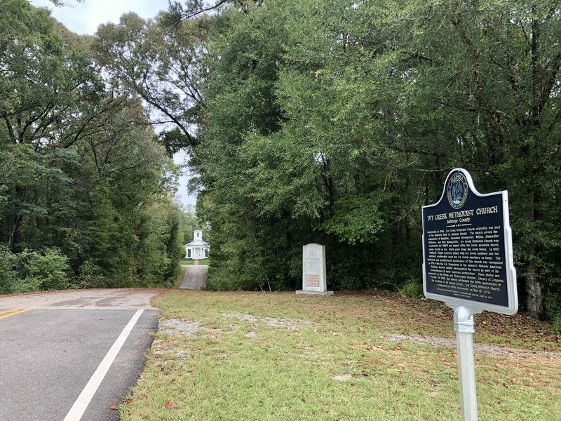
Ivy Creek Methodist Church can be see in far distance.
On Alabama Route 14, 0.4 miles west of County Road 9, on the right when traveling west.
Constructed in 1854, Ivy Creek Methodist Church originally was part of the Mulberry Beat in Autagua County. The church served the communities of Hamilton, Huckabee (Evergreen), Milton, Statesville-Mulberry, and West Autaugaville. Ivy Creek Methodist . . . — — Map (db m158666) HM
On Alabama Route 59 at milepost 56, on the right when traveling north.
William Bartram, America’s first native born artist - naturalist, passed through Baldwin County during the Revolutionary era, making the first scientific notations of its flora, fauna and inhabitants. As the appointed botanist of Britain’s King . . . — — Map (db m81855) HM
On Fort Mims Road north of Boatyard Road (County Route 80), on the right.
Front:
In 1813, people on the United State’s southwestern frontier were fearful. The Redstick faction of the Creek Indian Nation opposed growing American influence in the area and had voted for war. However, Creeks living in the Tensaw . . . — — Map (db m116678) HM
On Alabama Route 225 just north of Lower Bryants Landing Road, on the left when traveling north.
Here on the banks of the Tensaw River -- named for the Tensa Indian tribe whose principal village was located at this place -- Major Robert Farmar developed a plantation c. 1772. Farmar was one of the most prominent and controversial Alabamians of . . . — — Map (db m66380) HM
On West Barbour Street, on the left when traveling west.
Built between 1856 and 1860 by Edward Brown Young and his wife, Ann Fendall Beall, this was one of the first of the great Italianate style homes constructed in Eufaula. It later became the home of the builders’ daughter, Anna Beall Young, and her . . . — — Map (db m33759) HM
On North Randolph Avenue just south of East Browder Street, on the left when traveling south.
Side 1
Fairview contains a diverse collection of statuary, grave emblems and monuments amid a picturesque park-like setting. Many monuments are attributed
to the Tansey family who owned a monument company in Eufaula and operated their marble . . . — — Map (db m173638) HM
On Montevallo Road (State Highway 25) at Six Mile School Road, on the left when traveling west on Montevallo Road.
Incorporated in 1859 though organized earlier and operated continuously through 1897. First trustees were William P. Thomas, Leroy T. McGuire, Ezekiel C. Smith, Simpson W. Hederick and Pulaski Wallace. This noted center of learning in Bibb County . . . — — Map (db m37053) HM
On Halso Mill Road (County Route 59) 0.1 miles south of Mt. Zion Road (County Road 65), on the left when traveling south.
The Butler County Electric Membership Corporation was formed as a rural electric cooperative in Greenville in July 1938. The first home receiving electricity from the cooperative was located near here.
The Cooperative's original Board of . . . — — Map (db m70756) HM
Near Braggs Road (Alabama Route 263) 0.4 miles north of Sherling Lake Road (County Road 44), on the left when traveling north.
Commissioned and opened to the public in 1950, Sherling Lake is part of the Alabama Department of Conservation's efforts to construct public fishing lakes throughout Alabama in the 1940s. Greenville Chamber of Commerce President A.G. Johnson . . . — — Map (db m228690) HM
On McCullars Lane west of County Road 73, on the right when traveling east.
James Crook established this cemetery in
1837 on land he purchased from Creek
Indians. In 1834, he and his family moved
to this area from South Carolina.
In Nov. 1837, Samuel M. Crook, grandson
of James Crook, was the first person buried
here. . . . — — Map (db m36552) HM
On Quintard Avenue (U.S. 431) at East 13th Street, on the right when traveling north on Quintard Avenue.
Temple Beth El is the oldest building continuously used for Jewish worship in Alabama. Anniston’s Reform Jewish congregation was established in 1888. Its women’s organization, the Ladies Hebrew Benevolent Society, directed the construction of the . . . — — Map (db m36543) HM
In April 1888, the founder of a newly established Reform Jewish congregation purchased twenty-three lots in Hillside Cemetery to bury their deceased members.
In 1987, the City of Anniston vacated right-of-way that allowed the Temple to expand the . . . — — Map (db m53163) HM
On B Street at 1st Place SW, on the right when traveling north on B Street.
Vines Funeral Home and Ambulance Service was established in 1952
and is representative of a mid-20th century rural African American
funeral home. It is the only funeral home in Alabama still operating
an ambulance service. The main building of . . . — — Map (db m151221) HM
On Railroad Street north of Main Street (State Route 22), on the left when traveling north.
This structure is an excellent example of the one-room Gothic Revival - style church buildings which once were built throughout the South. It was originally located on a three-acre site that was deeded to trustees W. A. D. Ramsey, G. W. Brand, and . . . — — Map (db m37615) HM
On Little Drive (Little Place Cemetery Drive), 0.2 miles east of Ararat Road (County Route 23), on the left when traveling east.
Little Place Cemetery
Little Place Cemetery is a community cemetery that serves the African American Womack Hill community and its descendants. The establishment of the cemetery is linked to the founding of Mt. Pleasant Baptist Church, . . . — — Map (db m240385) HM
On Alabama Route 141, 0.4 miles south of County Route 404, on the left when traveling south.
The first burial here was James Shorter Grimes who died May 20, 1903, at the age of 48. His wife, Malissia Tillis, and 9 of their 14 children are also buried here. Their son, John Temple Grimes, along with M.G. Caylor and A.D. Donaldson purchased a . . . — — Map (db m231394) HM
On Railroad Street, 0 miles south of West College Street, on the right when traveling south.
This building was built in 1903 with additions in 1916 and 1997. The first freight shipments and passengers came here on the Alabama Midland railroad in 1898 immediately after construction of the roadbed. That was also the year when most of the . . . — — Map (db m30307) HM
On Brown Hawkins Road at Fall Lane, on the left when traveling north on Brown Hawkins Road.
Side 1
Doctor Reverend Hillary James Hawkins, who was affectionately known throughout the community as “Brown,” dedicated most of his adult life to providing spiritual guidance to blacks in Evergreen and surrounding . . . — — Map (db m81292) HM
On Alabama Route 22 west of Alabama Route 9, on the right when traveling west.
Peace & Goodwill Cemetery is Coosa County's first African American Cemetery to be placed on the prestigious Alabama Historic Cemetery Register. It provides powerful insights about the diligence and commitment of our African Ancestors. Family . . . — — Map (db m64587) HM
On West 3rd Street (Alabama Route 15) near Glenwood Avenue, on the right when traveling east.
Crenshaw County was established from five existing counties in 1866. The first courthouse and county seat were originally in Rutledge. The county seat moved to its present location after the 1893 election. The first courthouse at this location . . . — — Map (db m183474) HM
On Forest Avenue at West 9th Street, on the right when traveling south on Forest Avenue.
In 1904, Alabama industrialist Frazier Michel
Douglass, Sr. hired a carpenter from Alexander
City, Alabama to build the Douglass House. The
house is a two-story Queen Anne Victorian and
might be the only home of this architectural type
in . . . — — Map (db m163677) HM
On Glenwood Avenue at East 4th Street, on the right when traveling north on Glenwood Avenue.
In the late 1800s, Benjamin R. Bricken,
Crenshaw County's first attorney-at-law, built
the Bricken Building, a landmark in the field
of law in this county. Between 1893 and 1933,
the Bricken Law Firm occupied the building
Then, Ben H. Lightfoot . . . — — Map (db m163730) HM
On 3rd Street Northeast (U.S. 278) at 4th Avenue Southeast, on the right when traveling east on 3rd Street Northeast.
“Die Deutsche Kolonie Von Nord Alabama” (The German Colony of North Alabama) lies south of Highway 278E and consists of 27 blocks containing 135 buildings representing various types of historic architecture. The . . . — — Map (db m33837) HM
On 3rd Street Northeast (U.S. 278E) at 6th Avenue Northeast, on the left when traveling east on 3rd Street Northeast.
The Betz Addition Historic District, also known as “Quality Hill”, lies to the north of Highway 278 East and is named in honor of Cullman’s first mayor, Fred Betz. The district is listed on the Alabama Register of Landmarks and Heritage. . . . — — Map (db m33839) HM
On County Road 846 north of County Road 844, on the right when traveling north.
Early settlers to Cullman County established Shady Grove Methodist Episcopal Church as a brush arbor in the 1870s on land homesteaded and donated by Richard McCain. Trustees, J. J. McKissack, W. H. Martin, J. C. Vickery, J. W. Kilgo, together with . . . — — Map (db m34244) HM
On East Broad Street (Alabama Route 27) 0.2 miles east of Union Street (Alabama Route 123), on the right when traveling east.
Constructed in c. 1900 by G. P. Dowling, the Dowling-Steagall House is a Classical Revival dwelling featuring a full-height portico with Ionic columns and an elaborate door surround. A judge and prominent businessman, G. P. Dowling organized Ozark's . . . — — Map (db m36510) HM
On Alabama Route 22, on the left when traveling east.
The Beloit Industrial Institute was founded in 1888 by Industrial Missionary Association, an area subdivision of the American Missionary Associations. The President of the Association, Dr. Charles B. Curtis, was a Presbyterian missionary and . . . — — Map (db m83504) HM
On Vine Street at 1st Street North, on the right when traveling north on Vine Street.
Prior to 1905, workmen in search of
salvageable bricks dismantled the old
Dallas County Courthouse (pictured
here). The grassy mound before you
contains the damaged bricks the
workmen left behind.
Cahawba was the county seat from . . . — — Map (db m112559) HM
On Capitol Avenue at Vine Street, on the right when traveling east on Capitol Avenue.
Alabama's first statehouse stood on this lot, but no drawing by a person who actually saw it has been found. It was built in 1819 and destroyed in 1833, before the invention of photography. There are many drawings of the statehouse, but all are pure . . . — — Map (db m75908) HM
On Oak Street north of Fifth North Street, on the left when traveling north. Reported permanently removed.
Two story brick slave quarters like the
one before you were not typical, but they
could be found in wealthy towns like
Cahawba.
Stephen Barker built these quarters in
1860 on the northern edge of town.
As you can see in the . . . — — Map (db m112472) HM
On Oak Street, 0.2 miles 2nd Street North, on the left when traveling north.
Two-story brick slave quarters like the
one before you were not typical, but they
could be found in wealthy towns like
Cahaba.
Stephen Barker built these brick quarters
and a fine brick home for himself in
1861 on the northern edge of . . . — — Map (db m150865) HM
On Vine Street near 2nd Street North, on the right when traveling north. Reported permanently removed.
The Cahaba Drug Store once covered this cellar hole. It was operated by Herbert Hudson and J. D. Craig.
On the same lot were T. L. Craig's large family grocery, Coleman's dry goods store, and Fellows' Jewelry.
All these men were related . . . — — Map (db m23008) HM
On Oak Street, 0.6 miles south of Capitol Avenue, on the right when traveling south.
Created by the Legislature
This cemetery was created by an act of
Alabama's Legislature on January 31,
1852. Cahaba's town council selected
this spot, but the Legislature had to
confirm their choice because all public
land within . . . — — Map (db m150864) HM
Two Ghost Towns?
Long before Cahawba was built as
Alabama's first state capital, there was
another village at this location. Just like
Cahawba, it thrived for about 50 years,
then disappeared.
About the year 1500 a group of . . . — — Map (db m112450) HM
In 1862 the Confederacy used one of
Cahawba's brick cotton warehouses to
temporarily house men captured at the
Battle of Shiloh. In 1863, they officially
converted the warehouse into a military
prison. The inmates called it "Castle . . . — — Map (db m112528) HM
On Vine Street, on the right when traveling north. Reported permanently removed.
This cellar was under Joseph Babcock's brick store. During the Civil War the building was used as a commissary.
Babcock's warehouse and cotton shed were located to your right on the bluff overlooking the river. The family home, kitchen, and . . . — — Map (db m23287) HM
Near 2nd Street North near Vine Street. Reported permanently removed.
A "row" was a 19th century shopping mall. The word was used when a building or block had several similar storefronts arranged in a straight line or row.
This cellar marks the spot where David and Nicholas Crocheron built a large 2 story brick . . . — — Map (db m83509) HM
On Vine Street, on the right when traveling north. Reported permanently removed.
The grassed over mound of brick before you was once Dallas County's courthouse. This courthouse was built in 1834. It was dismantled prior to 1905 by brick salvagers.
Cahawba was the county seat from 1818 to 1866. This brought a lot of people, . . . — — Map (db m23010) HM
On Second Street North at Vine Street, on the left when traveling west on Second Street North.
On a May afternoon in 1856, an angry
John A. Bell rounded this corner
carrying a large hickory stick. He passed
by Edward Perine's fine brick store, and
continued south down the sidewalk.
Under his coat, he carried two pistols
and a . . . — — Map (db m112527) HM
On Vine Street south of 2nd Street North, on the right when traveling north.
The Drug Store
This hole was once the cellar beneath a
drug store operated by Herbert Hudson
& James D. Craig. They sold medicines,
chemicals, paints, perfumes, and cigars.
On the same lot was Thomas L. Craig's
large family . . . — — Map (db m150849) HM
On Vine Street, 0.1 miles south of Capitol Street, on the left when traveling south.
St. Luke's Episcopal Church was built at Cahawba in 1854 but was dismantled and moved sometime after 1884 but before 1888. It was reassembled fifteen miles away in a rural community called Martin's Station. The raised outline before you indicates . . . — — Map (db m83510) HM
On Oak Street (County Road 155), on the left when traveling north. Reported permanently removed.
In 1866, shortly after the Civil War and a severe flood, the county seat was moved from Cahaba to Selma. Residents rapidly abandoned the town. Many homes were dismantled and reassembled elsewhere.
Despite this trend, returning Confederate . . . — — Map (db m83516) HM
These are not graves.
These are markers to memoralize
the Federal soldiers who died in the
Cahawba Military Prison during the
Civil War. The men within the prison
called it "Castle Morgan."
No one knows where in Cahawba these . . . — — Map (db m112409) HM
On Mulberry Street south of First South Street, on the left when traveling south.
These ruins were once a place of worship for members of the Methodist Episcopal Church South. Built in 1849, it was the first single denomination church in Cahawba. An earlier church for the common use of all denominations was erected about 1840. . . . — — Map (db m112410) HM
On Vine Street north of Capitol Avenue, on the right when traveling north.
Brick Store to Depot
In 1858, the Cahaba, Marion and Greensboro Railroad company laid train tracks down Capitol Street so bales of cotton could be transported from distant plantations to warehouses in Cahaba. From the warehouses, the cotton . . . — — Map (db m150848) HM
On 1st Street North, on the left when traveling west. Reported permanently removed.
In the late 1850s, Cahaba experienced a building boom. Everyone expected the town to prosper because of the new railroad. One of the first large brick structures built in this prosperous period was completed in 1856 by Dr. Saltmarsh.
He . . . — — Map (db m23009) HM
On Vine Street at 1st Street North, on the right when traveling south on Vine Street.
In the late 1850s, Cahawba experienced
a building boom. Everyone expected
the town to prosper because of the new
railroad.
One of the first structures built during
this prosperous period was completed on
this corner in 1856 by Dr. . . . — — Map (db m150847) HM
On Capitol Avenue, on the right when traveling east.
This structure collapsed in 1833 and its fallen remains were reportedly heaped into a railroad embankment. Consequently, we have no picture of the Statehouse that was drawn by someone who actually saw the building. Any modern picture you see of this . . . — — Map (db m75909) HM
On Vine Street, on the left when traveling south. Reported permanently removed.
St. Luke's was consecrated in 1854. It was an outstanding example of the Gothic Revival style, popular at the time. The contractor closely followed designs in a widely circulated book, Rural Architecture, published in 1852 by the celebrated . . . — — Map (db m75922) HM
Near 2nd Street North. Reported permanently removed.
The Crocherons were from Staten Island, New York. Richard Conner Crocheron arrived in town about 1837 to help run the family store. He traveled north for his bride in 1843 after building her this brick home. The back wall adjoined the brick store . . . — — Map (db m22870) HM
On Oak Street near 2nd Street North, on the left when traveling north. Reported permanently removed.
In 1889, Samuel and Sarah Kirkpatrick moved to Selma, leaving their farm and house in the capable hands of their son Clifton (1863-1930). He turned the abandoned remains of Alabama's first capital into a showcase farm of diversified, scientific . . . — — Map (db m23005) HM
On Oak Street north of Fifth North Street, on the left when traveling north.
Look around you. There are hundreds
of pecan trees growing nearby. All were
planted by Clifton Kirkpatrick, a.k.a.
The Duke of Cahaba." (Note: Cahawba
lost its "w" by the late 19th century.)
In 1889 Samuel and Sarah Kirkpatrick . . . — — Map (db m112473) HM
1822 - Crocheron's Row
Cahawba's First Shopping Center
This large hole was dug in 1822 to be the
basement beneath Cahawba's first brick
store.
In the 19th century the word "row"
described a building that consisted of . . . — — Map (db m112577) HM
On Vine Street at Capitol Avenue, on the right when traveling north on Vine Street.
Between AD 1500 and 1600, the
indigenous inhabitants of the area around
the confluence of the Cahaba and
Alabama Rivers built a flat-topped mound
measuring about ½ acre in size. The
mound was the central feature of a
semicircular village . . . — — Map (db m150834) HM
Near 2nd Street North near Vine Street. Reported permanently removed.
By 1858 many brick stores had been built in Cahaba, so everyone called this the "old brick store." Merchant Sam M. Hill turned the building into one huge dry goods store where shoppers could buy just about anything!
Col. Hill, like most of the . . . — — Map (db m23242) HM
On Vine Street at Capitol Avenue, on the right when traveling north on Vine Street. Reported permanently removed.
Vine Street was Cahawba's business district. Stores, offices and hotels were tightly packed together along these three blocks. Homes were scattered over an entire square mile. Nearly every house had a yard of one or two acres. — — Map (db m83520) HM
On Vine Street at Capitol Street, on the right when traveling north on Vine Street. Reported damaged.
Cahawba's homes were spread over an
entire square mile, many with yards of
one or two acres. That was not the case
here on Vine Street. Offices, stores and
hotels were tightly packed along this
main street. The steamboat landings on
the . . . — — Map (db m112560) HM
This house, the Fambro / Arthur home,
takes its name from two of its owners.
One was a judge, the other was a former
slave.
The Fambro Family
A. Judge W. W. Fambro built this house
in the early 1840s. He may have created . . . — — Map (db m112451) HM
On Capitol Street at Walnut Street, on the right when traveling west on Capitol Street.
Walnut Street was the working
backside of the business district.
Cahaba's mechanics and enslaved
laborers knew this street well. It was a
place of livery stables, harness makers,
carriage makers, and blacksmiths. It
was a smelly, dirty street. . . . — — Map (db m150850) HM
A New York merchant, Richard Conner
Crocheron, built a magnificant mansion
on this spot. The adjacent photograph
captured the decayed splendor of this
home before it burned. Look closely
at the photograph. Try to identify the
columns . . . — — Map (db m112582) HM
On Union Street at Furniss Avenue, on the left when traveling north on Union Street.
This Greek revival mansion was built c. 1853 for William B. King and named “Fairoaks” for the many trees found about the place. King was the nephew of Vice President William Rufus King. Ann B. Wilson, a half-sister of the builder, . . . — — Map (db m83521) HM
On Union Street at McLeod Avenue, on the left when traveling south on Union Street.
Once a gracious turn-of-the-century neighborhood, many of the homes here were close to condemnation when purchased by Circle “S” Industries, Inc. in 1980. In all, 12 Victorian cottages were renovated in the area.
Built between 1870 . . . — — Map (db m37651) HM
On Broad Street (U.S. 80), on the right when traveling north.
Highlights of Selma History
Dallas County was created by Territorial Legislature Feb. 9, 1818. Selma Land Company formed Mar. 19, 1819 by George Phillips, William Rufus King, Jesse Beene, Gilbert Shearer and Caleb Tate. Selma incorporated . . . — — Map (db m37679) HM
On Tremont Street, on the right when traveling south.
This was the residence of John Tyler Morgan (1824-1907), one of Alabama’s most honored political and military leaders. Constructed in 1859 by Thomas R. Wetmore, it was purchased by Morgan in 1865, and served for many years as his principal . . . — — Map (db m37676) HM
On Union Street at Alabama Avenue on Union Street.
Central Masonic Institute of Alabama acquired property 1847 and erected building. Confederate Hospital during War Between the States. Dallas County Courthouse (1866-1901) on removal of County Seat from Cahaba. Presbyterian High School for Boys in . . . — — Map (db m37656) HM
On Tremont Street at McLeod Avenue, on the right when traveling south on Tremont Street.
This Greek Revival dwelling was built c. 1850 by Dr. Albert Gallatin Mabry, a prominent physician and member of the Alabama Legislature. Dr. Mabry was a leader in organizing the Alabama State Medical Association and instrumental in passing . . . — — Map (db m83580) HM
On Lauderdale Street at Selma Avenue, on the right when traveling north on Lauderdale Street.
Side A The original church, built one block south of the present site, was consecrated in 1843 by Bishop Leonidas Polk. In 1861, the second Bishop of Alabama, the Rt. Rev. Richard H. Wilmer, was elected there. During the Battle of Selma, St. . . . — — Map (db m37691) HM
On Broad Street (U.S. 80) at Water Avenue, on the right when traveling north on Broad Street. Reported permanently removed.
(The Beginning)
The major civil rights protest, which focused national attention on the issue of racial discrimination in voting & led to the passage of the Voting Rights Act of 1965, was centered in Selma.
In January of 1963 local . . . — — Map (db m37662) HM
Edgar Cayce (1877-1945), was internationally accepted as an extremely gifted psychic. An humble man, he never profited materially from his psychic ability, but used it to help “make manifest the love of God and man.” Operated his photography . . . — — Map (db m83680) HM
On Lauderdale Street, on the right when traveling north.
Built c. 1859 by Henry H. Ware, this house exemplifies the picturesque eclecticism which dominated Alabama architecture after 1850. It mixes elements of the older neoclassicism with the newer Victorian trends.
Prominent owners through the years . . . — — Map (db m37675) HM
On Water Avenue at Washington Street, on the right when traveling east on Water Avenue.
Selma’s Water Avenue is one of the finest surviving examples of a 19th century riverfront street in the south. Located here are structures which reflect the architectural trends in commercial buildings from 1830 to 1900.
This was the main . . . — — Map (db m37669) HM
On Mabry Street south of Jeff Davis Avenue, on the right when traveling south.
This Italianate style cottage was built in 1859 by C. B. and Martha Todd White. Mrs. White, half sister of Mrs. Abraham Lincoln, was an outspoken Southern patriot, who subjected the Lincolns to severe criticism, when the Northern press accused her . . . — — Map (db m38274) HM
On 5th Street south of Gault Avenue North (U.S. 11), on the right when traveling north.
Around 1889-1891 Fort Payne experienced a great industrial boom due to promotion by New England investors who speculated greatly on the area’s mineral deposits. During this period several highly ornate commercial and civic buildings, along with the . . . — — Map (db m28027) HM
On Jordan Avenue near Barnett Boulevard (Alabama Route 14), on the right when traveling north.
The history of this church encompasses the span of worldwide Methodism from the time of John Wesley to the present. A Methodist Society was organized in Tallassee in 1853 by 15 charter members who gathered in the "White Store," a mill company . . . — — Map (db m160158) HM
On Lancaster Street, 0.1 miles north of Holtville Road (Alabama Route 111), on the right when traveling north.
Constructed in 1924 on five acres, this building was one of nine schools constructed in Elmore County with funding assistance from the Julius Rosenwald Fund. Between 1912-32, Julius Rosenwald, a Jewish philanthropist and CEO of Sears, Roebuck and . . . — — Map (db m70548) HM
Near West Fort Toulouse Road, 0.6 miles west of Jackson Park Road.
This earthen mound and an adjacent
village were built by people of the
Mississippian culture who likely had
some relationship to the major mound
center at Moundville near present-day
Tuscaloosa. The Mississippian culture is
believed to have . . . — — Map (db m145084) HM
On North Broad Street at West Coosa Street, on the right when traveling north on North Broad Street.
The Louisville & Nashville Depot was built in Wetumpka in 1906 and exemplifies the L&N plan for small town depots. The station served as a passenger and freight depot until service was terminated in the 1930s and as a freight depot until 1973. In . . . — — Map (db m83724) HM
On Dixon Center Road, 1.6 miles north of U.S. 29, on the right when traveling north.
Dixon Home Place
Four generations of Dixons, each promoting the management of trees as a renewable resource, made their living in forestry on this ground thereby contributing significantly to Alabama’s economy and forest industry. . . . — — Map (db m130670) HM
On East Street at Northeast Street, on the left when traveling east on East Street.
On November 5, 1909, a group of worshipers gathered in the Congregational Church on the corner of St. Joseph and Evergreen Streets and organized the Second Saint Siloam Missionary Baptist Church. On June 10, 1910, the Second Saint Siloam Missionary . . . — — Map (db m130671) HM
On Chestnut Street at South 9th Street, on the right when traveling east on Chestnut Street.
This stately Classic Revival house, built c. 1904, was the residence of Colonel Oliver Roland Hood (1867-1951), eminent Gadsden attorney and civic leader. Colonel Hood was one of the three incorporators of Alabama Power Company in 1906 and author of . . . — — Map (db m83732) HM
On Chestnut Street at South 11th Street, on the right when traveling east on Chestnut Street.
The Eleventh Street School, built in 1907, was one of the earliest elementary schools in Gadsden. It is the only local surviving school building of that era.
This two-story red brick structure has solid masonry exterior walls and an entrance which . . . — — Map (db m83734) HM
On South 1st Street, on the right when traveling north.
Built of local sandstone in 1935 on land obtained from the American Legion Post No. 5 this municipal amphitheatre seating about 1600 was constructed for staging theatrical and sporting events. Gadsden architect Paul W. Hofferbert designed the . . . — — Map (db m39140) HM
On Broad Street at North 5th Street, on the right when traveling west on Broad Street.
This Italianate brick commercial structure with a cast-iron storefront on the first floor is significant for its 24 year association with Gadsden’s principal newspaper. It was constructed in 1904 to house The Gadsden Times-News, which was . . . — — Map (db m39217) HM
On Chestnut Street at South 9th Street, on the right when traveling east on Chestnut Street.
Built in 1886 for Edward Tracy Hollingsworth, a prominent merchant and banker, this two-story Victorian - style house with mansard roof is one of the few surviving examples of late-nineteenth century architecture in Gadsden. The original complex . . . — — Map (db m39134) HM
On North Jackson Avenue at Lauderdale Street NW, on the right when traveling south on North Jackson Avenue.
In 1867, community members established First Baptist Church in the heart of Russellville, Alabama. From its beginning, First Baptist Church has sought to glorify Christ and live out the Great Commission. The church held services in the Methodist . . . — — Map (db m243631) HM
On Jail Springs Road east of Alabama Route 187, on the left when traveling east.
After the northern portion of the county was taken to create Colbert County. An election was held to move the county seat to a more central location. In 1878. Jesse Amos Bolton surveyed and laid out the streets of the new town of Belgreen. An early . . . — — Map (db m215988) HM
On South Commerce Street (Alabama Route 27) north of East Church Avenue, on the right when traveling south.
Mrs. Emma Knox Kenan established the library at the request of school superintendent W.W. Benson in a small cloak room of the Geneva School. The library was financed by subscriptions, book rentals and fund raisers. The property where the library now . . . — — Map (db m131869) HM
On South Academy Street south of East Campbell Avenue, on the right when traveling south.
Built in 1888 by W.K. and Emma Knox Kenan, this
home is an excellent local example of Victorian
Cottage architecture. The Kenan's settled in
Geneva in 1882 and were charter members of the
Geneva Presbyterian Church established in 1884.
Despite . . . — — Map (db m167707) HM
On Alabama Route 39, 0.1 miles west of Alabama Route 14, on the right when traveling west.
This church was organized in 1838 as Concord Baptist Church, located nearby on Trussells
Creek. The first minister was Rev. William Manning. Charter members were: Mr. and Mrs.
Moses Buttler, Mr. and Mrs. Thomas Childs, Mr. and Mrs. Marshall Keith, . . . — — Map (db m203606) HM
On County Road 117, 0.1 miles east of County Road 20, on the right when traveling east.
In 1800, Thomas Reeves purchased 150 acres of land in this area and then passed it to his daughter, Elizabeth Reeves Hales in 1836. Rev. William Stith and Elizabeth Davie Hardy came to the West Greene community in 1879, where they bought a farm and . . . — — Map (db m203612) HM
On Mound Parkway at State Highway 69, on the right when traveling west on Mound Parkway.
Site of a prehistoric Native American political and ceremonial center from about A. D. 1100-1500 that, at its height in the 13th century, was America’s largest community north of Mexico. Between 1,000 and 3,000 people lived in this town fortified . . . — — Map (db m30700) HM
On Mound Parkway, 0.6 miles west of Alabama Route 69, on the right when traveling west.
I do not think in the Southern States there is a group of Mounds to compare to Moundville, in the arrangement and state of preservation of the mounds.
- Clarence B. Moore, amateur archaeologist, 1910
Spanning more than . . . — — Map (db m144745) HM
On E Peachtree Street, on the right when traveling west.
Marker front:
Constructed in 1911-1912 and designed by architect Richard H. Hunt, the Jackson County Courthouse is a Neo-Classical, brick building situated on a town square in Scottsboro, the county seat of Jackson County. The front, . . . — — Map (db m22264) HM
The Memphis and Charleston Railroad Company constructed the Scottsboro Railroad Depot in 1860-1861 as a passenger and freight facility. The rail line ran throughout the Confederacy and the Union considered its capture vital to cutting off supplies . . . — — Map (db m22258) HM
Near Sawmill Road, on the right when traveling south.
Constructed by the Union Army in the summer of 1862 and expanded in 1864, using soldiers and freed slaves, Ft. Harker was built on a broad hill a quarter mile east of town. It overlooked Crow Creek and was well within firing range of Stevenson's . . . — — Map (db m83795) HM
On West Main Street (State Highway 117), on the left when traveling south.
A one-story depot building was constructed here in 1853, when the railroad was first laid through Stevenson. That building burned after the Civil War and was replaced by the present brick depot and hotel in 1872.
During the Civil War, Stevenson . . . — — Map (db m22271) HM
Near Messer Airport Highway at University Avenue, on the right when traveling north.
This cemetery is the final resting place of three of the four young girls killed in the September 15, 1963 church bombing of the 16th Street Baptist Church. Addie Mae Collins, Cynthia Wesley and Carol Robertson are buried here. The fourth victim, . . . — — Map (db m61197) HM
The Corey Land Company, a group of prominent local businessmen headed by Robert Jemison, Jr., developed Belview Heights as a neighborhood for the professional employees of U.S. Steel in the 1910's. Extending the grid system being used in Ensley over . . . — — Map (db m24351) HM
On 19th Street North at 4th Avenue North, on the right when traveling north on 19th Street North.
On Mother's Day, May 14, 1961, a group of black and white CORE youth on a "Freedom Ride" from Washington, D.C. to New Orleans arrived by bus at the Birmingham Greyhound terminal. They were riding through the deep south to test a court case, "Boynton . . . — — Map (db m83809) HM
211 entries matched your criteria. The first 100 are listed above. Next 100 ⊳