After filtering for Florida, 409 entries match your criteria. The first 100 are listed. ⊳
Colonial Era Topic
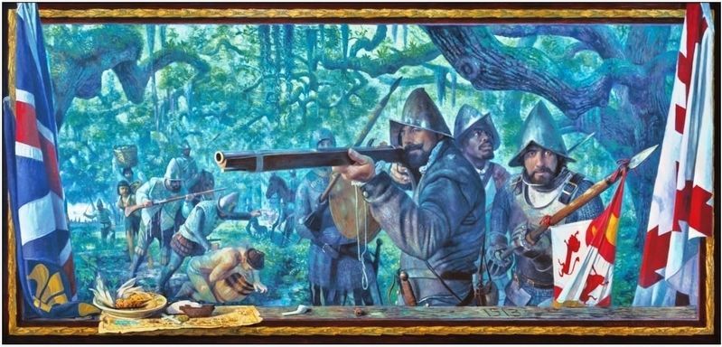
Courtesy of Christopher M. Still
Marker detail: Taking of Indians was the highest priority of De Soto’s soldiers
| 1 ► Florida, Alachua County, Gainesville — 19 — Forced into Service — Florida De Soto Trail — August 13, 1539 — |
| On NW 83rd Street north of North West South Road, on the left when traveling north. | |||
| 2 ► Florida, Alachua County, Gainesville — Living Links to Florida's Past — |
| Near Southeast 15th Street (Camp Ranch Road), 0.4 miles south of Southeast 41st Avenue when traveling south. | |||
| 3 ► Florida, Alachua County, High Springs — 21 — Fear Stricken — Florida De Soto Trail — August 15, 1539 — |
| Near SE Oleno Park Road, 2 miles east of US Highway 41 (U.S. 441) when traveling east. | |||
| 4 ► Florida, Alachua County, Micanopy — F-75 — William Bartram — (1739-1823) — |
| On NE Cholokka Blvd (County Road 234), on the left. | |||
| 5 ► Florida, Alachua County, Newberry — William Bartram Trail — Traced 1773 - 1777 — Deep South Region — |
| On US Hwy 27 & 41 (U.S. 27) at Northwest 16th Avenue, on the right when traveling north on US Hwy 27 & 41. | |||
| 6 ► Florida, Brevard County, Cape Canaveral — Cape Canaveral's Native Americans — |
| On Lighthouse Road north of Control Tower Road, on the left when traveling north. | |||
| 7 ► Florida, Brevard County, Melbourne — United States Army — Established June 14, 1775 — |
| On Oak Street south of East Hibiscus Boulevard, on the right when traveling north. | |||
| 8 ► Florida, Brevard County, Melbourne — United States Marine Corps — Established November 10, 1775 — |
| On Oak Street south of East Hibiscus Boulevard, on the right when traveling north. | |||
| 9 ► Florida, Brevard County, Melbourne — United States Navy — Established October 13, 1775 — |
| On Oak Street at East Hibiscus Boulevard, on the right when traveling north on Oak Street. | |||
| 10 ► Florida, Brevard County, Merritt Island — Revolutionary War Patriots — |
| Near South Sykes Creek Parkway south of Fortenberry Road, on the left when traveling south. | |||
| 11 ► Florida, Brevard County, Merritt Island — F-659 — Ulumay — |
| On Sykes Creek Parkway at Old Audubon Road, on the right when traveling south on Sykes Creek Parkway. | |||
| 12 ► Florida, Brevard County, North Merritt Island — F-566 — Haulover Canal — |
| Near Courtenay Parkway North (State Road 3). | |||
| 13 ► Florida, Brevard County, Wilson — William Bartram Trail — Traced 1773 - 1777 — Deep South Region — |
| Near Playalinda Road, 4 miles north of A. Max Brewer Memorial Parkway, on the left when traveling north. | |||
| 14 ► Florida, Brevard County, Wilson — William Bartram Trail — Traced 1773 - 1777 — Deep South Region — |
| Near Playalinda Road, 2.2 miles north of A. Max Brewer Memorial Parkway. | |||
| 15 ► Florida, Broward County, Fort Lauderdale — The Lewis Family — |
| On SW 9th Avenue at Coconut Drive when traveling north on SW 9th Avenue. | |||
| 16 ► Florida, Citrus County, Floral City — 13 — What Lies Ahead — Florida De Soto Trail — July 24, 1539 — |
| On East Orange Avenue / South Duval Island Drive east of South Shore Acres Point, on the right when traveling east. | |||
| 17 ► Florida, Citrus County, Inverness — 15 — Close to Starvation — Florida De Soto Trail — July 26, 1539 — |
| Near East Turner Camp Road (County Road 581) at Parker Street, on the right when traveling north. | |||
| 18 ► Florida, Citrus County, Inverness — Florida's First People — Seminole Heritage Trail — |
| Near Old Floral City Road, 0.2 miles south of Carnegie Drive, on the right when traveling south. | |||
| 19 ► Florida, Citrus County, Inverness — 14 — Surprise Attack — Florida De Soto Trail — July 25, 1539 — |
| Near East Dampier Street east of North Mill Avenue when traveling east. | |||
| 20 ► Florida, Citrus County, Inverness — The Seminole in the Cove of the Withlacoochee — Seminole Heritage Trail — |
| Near Old Floral City Road, 0.2 miles south of Carnegie Drive, on the right when traveling south. | |||
| 21 ► Florida, Clay County, Green Cove Springs — F-480 — Fort San Fransisco de Pupo — |
| On Leonard C. Taylor Parkway (State Road 16), on the right when traveling east. | |||
| 22 ► Florida, Clay County, Orange Park — F-798 — Orange Park — |
| On Kingsley Avenue at Park Avenue (Route 17), on the right when traveling west on Kingsley Avenue. | |||
| 23 ► Florida, Clay County, Starke — Assault On Fort Mose (1740) — Walk Through Time — Camp Blanding Museum & Memorial Park — |
| Near Florida Route 16 at Tallahassee Street, on the right when traveling east. | |||
| 24 ► Florida, Clay County, Starke — First Muster At St. Augustine (1565) — Walk Through Time — Camp Blanding Museum & Memorial Park — |
| Near Florida Route 16 at Tallahassee Street, on the right when traveling east. | |||
| 25 ► Florida, Clay County, Starke — Global War On Terrorism — Florida Army National Guard — Camp Blanding Museum & Memorial Park — |
| Near Tallahassee Street, 0.1 miles north of Avenue B, on the right when traveling north. | |||
| 26 ► Florida, Columbia County, Fort White — 22 — A Chief is Seized — Florida De Soto Trail — August 17, 1539 — |
| Near SW Elim Church Road (County Road 238) 0.2 miles east of SW Ichetucknee Avenue, on the right when traveling east. | |||
| 27 ► Florida, Columbia County, Lake City — 23 — A Bargaining Chip — Florida De Soto Trail — September 10, 1539 — |
| On Northwest Falling Creek Road (County Road 131) 0.9 miles north of US Highway 41 (State Road 100), on the right when traveling north. | |||
| 28 ► Florida, Duval County, Jacksonville — Historic Newcastle Plantation — |
| Near Fort Caroline Road at Rogero Road, on the right when traveling west. | |||
| 29 ► Florida, Duval County, Jacksonville, Fort Caroline Shores — Spanish Pond — Fort Caroline National Monument — Timucuan Ecological and Historic Preserve — |
| On Ft. Caroline Road, on the right when traveling east. | |||
| 30 ► Florida, Duval County, Jacksonville, Fort George Island — A Very Comfortable Habitation — |
| On Palmetto Avenue, 2.1 miles north of Fort George Road, on the left when traveling north. | |||
| 31 ► Florida, Duval County, Jacksonville, Fort George Island — Fort George Island — The Plantation Era in Florida — |
| Near Palmetto Avenue, 2.1 miles north of Fort George Road when traveling north. | |||
| 32 ► Florida, Duval County, Jacksonville, Fort George Island — Jean Ribaut — |
| On Heckscher Drive (State Road 1A) south of Fort George Road, on the right when traveling south. | |||
| 33 ► Florida, Duval County, Jacksonville, Fort George Island — Slave Trade / La Traite d'Esclaves — The Port of Nantes / Le Port de Nantes — |
| Near Palmetto Avenue, 2.2 miles north of Fort George Road when traveling north. | |||
| 34 ► Florida, Duval County, Jacksonville, Fort George Island — Slave Trade / La Traite d'Esclaves — A Valuable Commodity / Une marchandise de grande valeur — |
| Near Palmetto Avenue, 2.2 miles north of Fort George Road when traveling north. | |||
| 35 ► Florida, Duval County, Jacksonville, Northside — F-842 — Sawpit Bluff Plantation — |
| On Sawpit Road, 0.1 miles north of Flounder Road, on the left when traveling north. | |||
| 36 ► Florida, Duval County, Jacksonville, Northside — F-138 — The Huguenot Memorial Site — |
| On Huguenot Memorial Park Road, 0.2 miles east of Heckscher Drive (State Road A1A), on the right when traveling east. | |||
| 37 ► Florida, Duval County, Jacksonville, Spring Park — Fort San Nicholas — |
| On Atlantic Boulevard (U.S. 90) at White Avenue, in the median on Atlantic Boulevard. | |||
| 38 ► Florida, Duval County, Jacksonville, St. Johns Bluff — Fort de la Caroline — Fort Caroline National Monument — Timucuan Ecological and Historic Preserve — |
| Near Ft. Caroline Road, on the left when traveling east. | |||
| 39 ► Florida, Duval County, Jacksonville, St. Johns Bluff — New France — Fort Caroline National Monument — Timucuan Ecological and Historic Preserve — |
| On Ft. Caroline Road, on the left when traveling east. | |||
| 40 ► Florida, Duval County, Jacksonville, St. Johns Bluff — Ribault Monument — |
| Near Ft. Caroline Road, on the left when traveling east. | |||
| 41 ► Florida, Duval County, Jacksonville, St. Johns Bluff — Staking a Claim — Ribault Monument — Timucuan Ecological and Historic Preserve — |
| On Ft. Caroline Road, on the left when traveling east. | |||
| 42 ► Florida, Duval County, Jacksonville, St. Johns Bluff — The Building of la Caroline — Fort Caroline National Monument — Timucuan Ecological and Historic Preserve — |
| Near Ft. Caroline Road, on the left when traveling east. | |||
| 43 ► Florida, Duval County, Jacksonville, St. Johns Bluff — The River of May — Fort Caroline National Monument — Timucuan Ecological and Historic Preserve — |
| On Ft. Caroline Road, on the left when traveling east. | |||
| 44 ► Florida, Duval County, Jacksonville, St. Johns Bluff — Timucuan Friends — Fort Caroline National Monument — Timucuan Ecological and Historic Preserve — |
| Near Ft. Caroline Road, on the left when traveling east. | |||
| 45 ► Florida, Duval County, Jacksonville, St. Johns Bluff — Timucuan Preserve — Fort Caroline National Monument — Timucuan Ecological and Historic Preserve — |
| Near Ft. Caroline Road, on the left when traveling east. | |||
| 46 ► Florida, Duval County, Jacksonville, Urban Core — King’s Road Meets Apalache Trail — |
| On W.Duval St. at N. Laura Street, on the left when traveling west on W.Duval St.. | |||
| 47 ► Florida, Duval County, Jacksonville, Urban Core — F-66 — Site of Cow Ford — |
| On E Bay Street at S Liberty Street, on the right when traveling east on E Bay Street. | |||
| 48 ► Florida, Duval County, Jacksonville, Urban Core — Soldiers of the American Revolution Associated with Jacksonville’s History — |
| Near Riverplace Boulevard (State Road 13) at Flagler Avenue. | |||
| 49 ► Florida, Escambia County, Pensacola — A Spanish Town — Florida's Territorial Bicentennial — |
| On South Jefferson Street at Zaragoza Street, on the right when traveling north on South Jefferson Street. | |||
| 50 ► Florida, Escambia County, Pensacola — American Period — Colonial Archaeological Trail — |
| On Zaragoza Street east of South Jefferson Street, on the left when traveling east. | |||
| 51 ► Florida, Escambia County, Pensacola — Archaeology in Pensacola — Colonial Archaeological Trail — |
| On Zaragoza Street west of South Tarragona Street, on the right when traveling west. | |||
| 52 ► Florida, Escambia County, Pensacola — Barkley House — Colonial Archaeological Trail — |
| On Zaragoza Street at South Florida Blanca Street, on the right when traveling east on Zaragoza Street. | |||
| 53 ► Florida, Escambia County, Pensacola — Battle of Pensacola — March 9 to May 8, 1781 — |
| On West La Rua Street at North Palafox Street, on the left when traveling east on West La Rua Street. | |||
| 54 ► Florida, Escambia County, Pensacola — British Governor's House? — Colonial Archaeological Trail — |
| On Zaragoza Street west of South Adams Street, on the right when traveling west. | |||
| 55 ► Florida, Escambia County, Pensacola — British Period — Colonial Archaeological Trail — |
| On Zaragoza Street east of South Jefferson Street, on the left when traveling east. | |||
| 56 ► Florida, Escambia County, Pensacola — British Well — Colonial Archaeological Trail — |
| On East Zaragoza Street east of South Tarragona Street, on the left when traveling east. | |||
| 57 ► Florida, Escambia County, Pensacola — Colonial Cooking — Colonial Archaeological Trail — |
| On Zaragoza Street east of South Jefferson Street, on the left when traveling east. | |||
| 58 ► Florida, Escambia County, Pensacola — Colonial Pensacola - Archaeology Brings History to Life |
| Near South Jefferson Street at East Zarragossa Street. Reported permanently removed. | |||
| 59 ► Florida, Escambia County, Pensacola — Commanding Officer's Compound — Colonial Archaeological Trail — |
| On Zaragoza Street west of South Adams Street, on the right when traveling west. | |||
| 60 ► Florida, Escambia County, Pensacola — Don Manuel Gonzalez — |
| Near North Alcaniz Street at W.D. Childers Plaza. | |||
| 61 ► Florida, Escambia County, Pensacola — Dorothy Walton — |
| Near North Alcaniz Street at W.D. Childers Plaza. | |||
| 62 ► Florida, Escambia County, Pensacola — First Spanish Period — Colonial Archaeological Trail — |
| On Zaragoza Street east of South Jefferson Street, on the right when traveling west. | |||
| 63 ► Florida, Escambia County, Pensacola — Fort George — Colonial Archaeological Trail — |
| On North Palafox Street at West La Rua Street, on the left when traveling north on North Palafox Street. | |||
| 64 ► Florida, Escambia County, Pensacola — Fort San Bernardo — |
| On North Spring Street at West Brainerd Street, on the left when traveling north on North Spring Street. | |||
| 65 ► Florida, Escambia County, Pensacola — Gaberonne — |
| On Manolete Street west of U.S. 90, on the right when traveling west. | |||
| 66 ► Florida, Escambia County, Pensacola — Garden Street — (La Calle Jardin) — |
| On West Garden Street at North Palafox Street, on the left when traveling east on West Garden Street. | |||
| 67 ► Florida, Escambia County, Pensacola — Garrison's Kitchen — Colonial Archaeological Trail — |
| On Church Street west of South Adams Street, on the right when traveling west. | |||
| 68 ► Florida, Escambia County, Pensacola — Gen. Andrew Jackson — In This Plaza — |
| Near East Zarragossa Street at South Palafox Street. | |||
| 69 ► Florida, Escambia County, Pensacola — John Innerarity — |
| Near North Alcaniz Street at W.D. Childers Plaza. | |||
| 70 ► Florida, Escambia County, Pensacola — Jose Noriega — |
| Near North Alcaniz Street near W.D. Childers Plaza. | |||
| 71 ► Florida, Escambia County, Pensacola — Luna Expedition — 450th Anniversary — February 19, 2009 — |
| On South Palafox Street near South Jefferson Street, on the right when traveling south. | |||
| 72 ► Florida, Escambia County, Pensacola — Officer's Room and Kitchen — Colonial Archaeological Trail — |
| On South Jefferson Street south of Church Street, on the right. | |||
| 73 ► Florida, Escambia County, Pensacola — Old Christ Church — Colonial Archaeological Trail — |
| On Zaragoza Street west of South Adams Street, on the left when traveling east. | |||
| 74 ► Florida, Escambia County, Pensacola — P.K. Yonge — |
| Near North Alcaniz Street at W.D. Childers Plaza. | |||
| 75 ► Florida, Escambia County, Pensacola — Second Spanish Period — Colonial Archaeological Trail — |
| On Zaragoza Street east of Jefferson Street, on the left when traveling east. | |||
| 76 ► Florida, Escambia County, Pensacola — St. Michaels Cemetery — Colonial Archaeological Trail — |
| On North Alcaniz Street south of East Chase Street, on the right when traveling north. | |||
| 77 ► Florida, Escambia County, Pensacola — Stephen R. Mallory — |
| Near North Alcaniz Street at W.D. Childers Plaza. | |||
| 78 ► Florida, Escambia County, Pensacola — Stop and Smell the Roses — Colonial Archaeological Trail — |
| Near Church Street east of South Jefferson Street, on the right when traveling east. | |||
| 79 ► Florida, Escambia County, Pensacola — The Commanding Officer's Compound |
| Near East Zarragossa Street at East Jefferson Street. Reported permanently removed. | |||
| 80 ► Florida, Escambia County, Pensacola — The End of the Colonial Era in Florida |
| Near East Zarragossa Street at South Jefferson Street. Reported permanently removed. | |||
| 81 ► Florida, Escambia County, Pensacola — Trenches & Trous-de-Loup — Colonial Archaeological Trail — |
| On South Jefferson Street south of Church Street, on the right when traveling south. | |||
| 82 ► Florida, Escambia County, Pensacola — Wells and Cellars — Colonial Archaeological Trail — |
| Near Zaragoza Street east of South Jefferson Street, on the left when traveling east. | |||
| 83 ► Florida, Escambia County, Pensacola — William Bartram Trail — Traced 1773-1777 — Deep South Region — |
| Near South Pace Boulevard, 0.1 miles south of Cypress Street when traveling south. | |||
| 84 ► Florida, Escambia County, Pensacola Beach — Colonial Power Struggle — Fort Pickens — |
| On Fort Pickens Road, 9.8 miles west of Pensacola Beach Boulevard (State Road 399), on the right when traveling south. | |||
| 85 ► Florida, Escambia County, Pensacola Beach — Converting a Cannon — Fort Pickens — |
| Near Fort Pickens Road, 9.8 miles west of Pensacola Beach Boulevard (State Road 399). | |||
| 86 ► Florida, Flagler County, Flagler Beach — Riding the "Jamaica Train" — The Operation of the Sugar House — |
| Near Old Kings Road South, 0.3 miles south of Audubon Way, on the left when traveling south. | |||
| 87 ► Florida, Flagler County, Marineland — Coquina — for Building & Broth — |
| Near North Ocean Shore Boulevard (Florida Route A1A) at Poole Drive, on the left when traveling south. | |||
| 88 ► Florida, Flagler County, Palm Coast — A Plantation in early Florida — Mala Compra Plantation Archaeological Site — |
| Near N Ocean Shore Blvd. (National Route A1A) 0.1 miles north of Mala Compra Drive. | |||
| 89 ► Florida, Flagler County, Palm Coast — F-22 — King's Road — |
| On North Old Kings Road, 0.3 miles north of Princess Place Road, on the right when traveling north. | |||
| 90 ► Florida, Flagler County, Palm Coast — F-530 — Princess Place Estate — |
| Near Princess Place Road, 2.5 miles east of North Old Kings Road. | |||
| 91 ► Florida, Franklin County, St. George Island — F-319 — William Augustus Bowles — |
| On E Gulf Beach Dr,. | |||
| 92 ► Florida, Gadsden County, Chattahoochee — Ellicott's Camp and Observatory — George Washington's Commissioner of Limits — |
| On River Landing Road, 0.3 miles south of U.S. 90, on the left when traveling west. | |||
| 93 ► Florida, Gadsden County, Chattahoochee — Old Spanish Trail — Florida's Historic Mission Road — |
| On River Landing Road, 0.3 miles south of U.S. 90, on the right when traveling west. | |||
| 94 ► Florida, Gadsden County, Chattahoochee — F-241 — Site of Ellicott's Observatory — |
| On River Landing Road, 0.2 miles south of U.S. 90, on the left when traveling south. | |||
| 95 ► Florida, Gadsden County, Quincy — F-263 — Old Washington Lodge No. 2 ~ Quincy Woman's Club — |
| On West King Street at North Calhoun Street, on the right when traveling west on West King Street. | |||
| 96 ► Florida, Gulf County, St. Joe Beach — F-115 — Fort Crèvecoeur — Fort Crèvecoeur Abandoned — |
| On Columbus Street (U.S. 98) at Beacon Road, on the right when traveling east on Columbus Street. | |||
| 97 ► Florida, Hernando County, Istachatta — 12 — Pressing Onward — Florida De Soto Trail — July 23, 1539 — |
| Near Lake Lindsey Road (County Road 476) 0.1 miles east of Lingle Road (County Road 439), on the left when traveling east. | |||
| 98 ► Florida, Hernando County, Richloam — 11 — Rumors of Riches — Florida De Soto Trail — July 20, 1539 — |
| Near Richloam Clay Sink Road, 0.1 miles east of Riverland Road, on the right when traveling east. | |||
| 99 ► Florida, Hillsborough County, Riverview — 5 — Saved from Slavery — Florida De Soto Trail — June 20, 1539 — |
| Near McMullen Road, 0.9 miles south of Boyette Road, on the left when traveling south. | |||
| 100 ► Florida, Hillsborough County, Ruskin — 3 — Landing in La Florida — Florida De Soto Trail — May 30, 1539 — |
| On Gulf City Road, 0.2 miles north of Cockroach Bay Road, on the left when traveling north. | |||
409 entries matched your criteria. The first 100 are listed above. Next 100 ⊳