On National Seashore Lane at Stephen Decatur Hwy (Virginia Route 617), on the right when traveling west on National Seashore Lane.
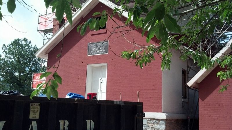
The historic Assateague Lighthouse is one of nearly 450 automated lighthouses maintained today by the U.S. Coast
Guard. First built by the U.S. Treasury Department in 1833 the
original 45-foot tower proved too low and dim to be effective. The . . . — — Map (db m205169) HM
On Main Street just west of Mumford Street, on the right when traveling west.
Boats and then bridges not only formed Chincoteague Island's lifelines to the mainland, they changed the island's way of life.
Beginning around 1881, after several years of irregular service by other boats, the steamboat Widgeon began . . . — — Map (db m165054) HM
Near Main Street at Post Office Street, on the right when traveling west.
First oysters, then bay and sea clams buoyed Chincoteague's economy.
During the second half of the 19th century, Chincoteague's seafood industry relied on the oyster. Each year, from September to April, island watermen gathered Chincoteague's . . . — — Map (db m165063) HM
On Main Street just west of Post Office Street, on the right when traveling west.
Historically, Chincoteague's western waterfront provided the town with its front door.
Many watermen sailed from docks along Chincoteague Channel, "goin' down da Bay" to return with cargoes of oysters, bay clams, mussels, and terrapins.
For . . . — — Map (db m165058) HM
On National Seashore Lane at Stephen Decatur Hwy (Virginia Route 611), on the right when traveling west on National Seashore Lane.
Between 1922 and 1967. the white buildings visible in the distance marked the center of lifesaving activities on this end of Assateague Island. The twelve-man crew of the Assateague Beach Coast Guard Station stood ready to aid vessels in distress . . . — — Map (db m205179) HM
On Main Street just west of Post Office Street, on the right when traveling west.
Decoys carved by Chincoteague residents have evolved into a form of art that is highly respected and collected. But decoy carving itself originated in the long tradition of waterfowl hunting.
Ducks and geese have always been a part of life on . . . — — Map (db m165059) HM
On Main Street just west of Post Office Street, on the right when traveling west.
In 1890, fish made the Chincoteague news. Islanders caught so many fin fish that a reporter claimed the take was never so large, or the "fish so fine."
Fish became so plentiful in Chincoteague markets that a local islander wrote in 1922 that . . . — — Map (db m165060) HM
Near Beach Access Road north of Boat Ramp Access Road, on the right when traveling south.
Listed on the National Register of Historic Places, the Assateague Island Lighthouse is a striking landmark that attracts many visitors. At the same time, it is an active aid to navigation, operated by the U.S. Coast Guard, that gives ships a . . . — — Map (db m98824) HM
On Main Street at Poplar Street, on the left when traveling west on Main Street.
In the early 20th century, without street lights or lighted homes to use as reference points, ferry boats from the Delmarva mainland would run aground as they approached Chincoteague Island.
Especially on dark nights, the Watson family would . . . — — Map (db m165071) HM
On Beach Access Road, 0.5 miles south of Wildlife Drive, on the right when traveling south.
Hardy, compact, and spirited—the horses on Assateague Island run freely over a range bounded by ocean and bay. Bands of mares and young led by protective stallions graze on marsh grasses, drink at freshwater ponds, and retreat into island . . . — — Map (db m98826) HM
On National Seashore Lane at Stephen Decatur Hwy (Virginia Route 611), on the right when traveling west on National Seashore Lane.
Since Colonial times, residents of Assateague and Chincoteague Islands have depended on fish and shellfish for food. By the time of the Civil War, islanders were exporting seafood to Northern cities. Toms Cove, or Chincoteaque, oysters . . . — — Map (db m205182) HM
Near Beach Access Road north of Boat Ramp Access Road, on the right when traveling south.
In the 1800s, after the lighthouse was built, a small community grew up not far from here. By the early 1900s, about 225 lived in the village, which included a school, dry goods store, and a church. The residents harvested resources from the sea, . . . — — Map (db m98825) HM
On Main Street just east of Mumford Street, on the right when traveling west.
Storms continually reshape coastal islands and challenge resilience of residents. Chincoteague is no exception. A hurricane, the Great September Gust, "leaped upon the devoted island with a scream" in 1821. A blizzard in January 1922 rammed ice . . . — — Map (db m165049) HM
Near Market Street at College Avenue, on the right when traveling west.
As John Smith helped settle Jamestown, he admired the capabilities of the Native Americans' log canoes. Colonists adopted the log canoe and used iron tools to improve the design. Early canoes were made from a single log, but as the need arose for . . . — — Map (db m165105) HM
On Market Street near South Street, on the left when traveling west.
Known as the Scott Hall Cemetery, it dates from the late 18th century. Here will be found the grave of Commodore Whaley of the Maryland Navy who was killed in the Battle of the Barges in the Chesapeake Bay near the mouth of Onancock Creek in . . . — — Map (db m7681) HM
Near Market Street at College Avenue, on the right when traveling west.
The Annie C, a five log canoe, is one of the largest canoes built on the Eastern Shore of Virginia. Designed as a work boat, she was built in 1904, by Horace Bundick in the Town of Sanford. After fastening five logs together with iron . . . — — Map (db m165115) HM
Near Market Street at College Avenue, on the right when traveling west.
As originally build, the Annie C did not have an engine, although various engines were added in later years. As exhibited now, she was sail only and steered by a 7 foot tiller. This tiller was carved using traditional tools from a 10 inch by 4" . . . — — Map (db m165106) HM
Near Market Street at College Avenue, on the right when traveling west.
Only the largest log canoes had a cabin. This cabin had bunks and slept 3-4 persons. It had a small wood stove (installed later) for cooking and heat in the winter. A large portion of the cabin is taken up the centerboard truck and the mast . . . — — Map (db m165113) HM
Near Market Street at College Avenue, on the right when traveling west.
Looking at the port side of the Annie C you see "knees" every 16 to 18 inches. The original knees were made of cedar taken from the tree at limbs that formed the desired shape. The knees were fitted to the side of the boats and attached . . . — — Map (db m165111) HM
Near Market Street at College Avenue, on the right when traveling west.
Annie C has five logs. A center or Keel Log (24 inches wide and 4 inches thick), a port and starboard wind logs (about 20 inches wide), and a port and starboard garboard logs (about 19 inches wide) the thickness goes from about 4 inches at the . . . — — Map (db m165109) HM
On Market Street, 0.1 miles west of Mt. Prospect Avenue, on the left when traveling west.
Before railways and highways, the waterways of the Eastern Shore of Virginia were the primary mode of transportation of people and goods. Thus, the Town of Onancock, founded in 1680, grew and flourished. Despite the move to rail and then . . . — — Map (db m165102) HM
On Bennett Street (Virginia Route 176) just west of Dunne Avenue, on the right when traveling west.
The Civil Air Patrol, a civilian organization established during World War II, operated Coastal Patrol Base Four about one mile west of here at the Parksley airport. Volunteers constructed runways and hangars, converted a farmhouse and chicken coop . . . — — Map (db m165077) HM
On Bannys Road at Factory Road, on the right when traveling south on Bannys Road.
At the south end of Main Ridge, the road becomes Banny's Road, which once led to Banty's Wharf. Banty's Wharf was named for Capt. John L. "Banty" who lived here with his wife, Mrs. Ellen Elizabeth Shores. For over 200 years the island's primary . . . — — Map (db m106987) HM
On Main Ridge Road north of Chambers Lane, on the left when traveling south.
At the end of Chambers Lane in an area once known as Chambers Wharf, site of the John Chambers Store. Lorraine's Sandwich Shop now occupies the site of the first Post Office, built in 1891.
The homes at 4411 and 4413 Chambers Lane were moved . . . — — Map (db m107002) HM
On Canton Road just south of Canton Road, on the right when traveling south.
This cemetery is the possible site of Lee’s Bethel, the island’s first church. Next to the cemetery is the last of the island’s once plentiful garden farms.
Tangiermen were famous for growing melons, filling their boats until just the gunnels . . . — — Map (db m97873) HM
Near Parks Marina Lane west of Main Ridger Road, on the right when traveling west.
Owner Milton Parks has provided warm hospitality to boaters for decades. His marina serves local watermen, commercial and recreational boat traffic.
(captions)
Milton Parks on his scooter - Kaye, 2005
Oyster Buy Boats at Park's . . . — — Map (db m106963) HM
Mailboat Harbor replaced Steamboat Harbor in the 1930’s as the age of steamboats came to a close. The harbor was first dredged in 1922, from the Eastern side. In 1967, the harbor was dredged through to the Western side of the island. This was a . . . — — Map (db m39554) HM
On Main Ridge Road at Williard's Lane, on the right when traveling south on Main Ridge Road.
The Double Six Sandwich Shop is where the watermen meet at 3:00 AM for "smokes and coffee" before heading down to the docks to the day's work.
Named for the game of Dominos, the shop is open for sandwiches year-round, and was often considered . . . — — Map (db m39683) HM
On West Ridge Road south of School Lane, on the left when traveling north.
The Emily Pruitt House was home to the island's sail-making seamstress, a critically important job before the invention of motorized boats. — — Map (db m106994) HM
On Main Ridge Road south of Dise Lane, on the left when traveling south.
Patrick Benson, a ship's captain from Dublin, Ireland, purchased this land in 1879. The middle section of house was completed in 1889. The front section with porch and back section with kitchen and outbuilding were added over the years, but . . . — — Map (db m106977) HM
Master carpenter James Dinsmore oversaw construction of this Ice House to Jefferson's design in 1802. Enslaved and hired workers filled it each year between November and February with ice cut from the nearby Rivanna River, shallow ponds, or snow . . . — — Map (db m68174) HM
On Thomas Jefferson Parkway (Virginia Route 53) at Michie Tavern Lane (County Road 1102), on the right when traveling east on Thomas Jefferson Parkway. Reported permanently removed.
Not far from the Tavern, the Michie family owned and operated a mill and general store. At the turn of the century the mill fell from decay. In order to recreate the Michie's Tavern-plantation (which stretched for several miles) Historic Michie . . . — — Map (db m53611) HM
Near Earlysville Road at Woodlands Road, on the right when traveling south.
This is a spring that was used by the Carr family when they lived here in 1870. The spring provided a source of clean drinking water and was also used as a storage location to keep perishable foods cool — — Map (db m170175) HM
On East Market Street (County Road 1105) 0.2 miles south of Riverside Avenue, on the right when traveling east.
The Woolen Mills area of Charlottesville traces its roots back to the late 1700s. It was Thomas Jefferson who realized the Rivanna River's vitality was the key to economic growth in the area.
Originally a grist mill was started on . . . — — Map (db m172975) HM
On Irish Road (Virginia Route 6) at James River Road, on the right when traveling west on Irish Road.
Five miles southwest of here is the Hatton Ferry on the James River which began operating in the 1870s. James A. Brown established the ferry and a store on land first rented and then purchased from S.P. Gantt in 1881. In 1883 when a post office was . . . — — Map (db m88501) HM
On Hatton Ferry Road, 0.5 miles south of Hatton Ferry Lane, on the right when traveling south. Reported missing.
Ferries In Virginia
The James, York, Rappahannock and smaller rivers were the primary means of commercial transportation in Virginia until the advent of railroads in the mid-1800’s. In most locations ferries provided the only way to cross . . . — — Map (db m14527) HM
On Hatton Ferry Road, 0.5 miles south of Hatton Ferry Lane.
History of Hatton Ferry.
The Hatton Ferry began operation in 1870, when Buckingham County authorities issued a court order to construct a public ferry across the James River to the Albemarle County lands of Thomas P. Gantt (ca. 1846-1896), a . . . — — Map (db m99392) HM
On Hatton Ferry Road, 0.2 miles south of Hatton Ferry Lane, on the left when traveling south.
James A. Brown began operating a store and ferry at this site on rented property in the late 1870’s. In 1881 he bought the land from S. P. Gantt at which time the store became a stop on the Richmond and Alleghany Railroad. Two years later, Brown was . . . — — Map (db m12882) HM
On North Paxton Street at Cloude's Mill Drive, on the right on North Paxton Street.
This historic site is a section of the mill race that provided water power to Cloud's Mill which stood directly across Paxton street.
At the intersection of Beauregard and Morgan Streets, water diverted from the Holmes Run ran through the . . . — — Map (db m150801) HM
Near Brenman Park Drive south of Duke Street (Virginia Route 236), on the left when traveling west.
Archaeologists excavated four ship hull remnants along the Alexandria waterfront — one from the Hotel Indigo Site (44AX229) and three from the Robinson Landing Site (44AX235). Over 200 years ago, Alexandrians repurposed these old merchant ships . . . — — Map (db m216125) HM
Near Brenman Park Drive south of Duke Street (Virginia Route 236), on the left when traveling west.
Archaeologists excavated four ship hull remnants along the Alexandria waterfront — one from the Hotel Indigo Site (44AX229) and three from the Robinson Landing Site (44AX235). Over 200 years ago, Alexandrians repurposed these old merchant ships . . . — — Map (db m216130) HM
Near Brenman Park Drive south of Duke Street (Virginia Route 236), on the left when traveling west.
Archaeologists excavated four ship hull remnants along the Alexandria Waterfront — one from the Hotel Indigo Site (44AX229) and three from the Robinson Landing Site (44AX235). Over 200 years ago, Alexandrians repurposed these old merchant ships . . . — — Map (db m216126) HM
On The Strand just south of Prince Street, on the left when traveling south.
1880
On September 1, 1880 the Old Dominion Boat Club (ODBC) was organized to combine physical fitness and sport with a social atmosphere. The members built their first clubhouse on May 1, 1881 located on the Strand between Duke and . . . — — Map (db m195594) HM
During World War I (1914-1918), the U.S. government targeted Jones Point as the site for a private shipyard, one of 111 built to aid the war effort. The Virginia Shipbuilding Corporation yard, constructed just before war's end, was designed to build . . . — — Map (db m127780) HM
Near Thompsons Alley east of North Union Street, on the right when traveling east.
The African American Heritage Trail along the waterfront consists of two interconnecting routes. Both begin at Waterfront Park. Together, these trails illuminate the history of the African American community in Alexandria over a span of several . . . — — Map (db m239718) HM
On Pioneer Mill Way just east of The Strand, in the median.
Alexandrians created waterfront land by banking out the shoreline using timber cribbing and old ships including three discovered on this site.
For over two centuries this land embodied Alexandria's working waterfront with an evolving mix of . . . — — Map (db m204474) HM
On South Lee Street at Green Street, on the right on South Lee Street.
Historical Site Defenses of Washington 1861-1865 Battery Rodgers
Here stood Battery Rodgers, built in 1863 to prevent enemy ships from passing up the Potomac River. The battery had a perimeter of 30 yards and mounted five 200 pounder Parrott . . . — — Map (db m41413) HM
On Prince Street just east of South Fairfax Street, on the right when traveling east.
This house was built between 1784-1786 by Colonel Michael Swope, a Revolutionary War Battalion Commander, and his wife, Eva Kuhn Swope. Originally from York, PA, Colonel Swope was taken prisoner by the British at the beginning of the war and was . . . — — Map (db m149717) HM
Near Wharf Street east of Ford's Landing Way, on the right when traveling west. Reported unreadable.
During the 17th century, settlers began to establish small plantations near landing places on the Potomac River. Oceangoing ships could load tobacco and other goods to export to Great Britain. The area that was to become Alexandria was still . . . — — Map (db m127772) HM
On King Street at South Royal Street, on the right when traveling east on King Street.
Alexandria's electric streetcar system, the Washington, Alexandria & Mount Vernon Railway, was established in 1892 between Alexandria and Mount Vernon. In 1896, the line extended into Washington, crossing the Long Bridge where the 14th Street Bridge . . . — — Map (db m115760) HM
On North Union Street at Princess Street, on the right when traveling north on North Union Street.
As Virginia's population grew, so did its reliance on fish from the Potomac River as a dietary staple. In 1813, the city authorities passed a law designating the county wharf at the foot of Oronoco Street as the official place for landing fish. . . . — — Map (db m239715) HM
The Alexandria waterfront has changed dramatically since the City's founding in 1749. The Potomac River once flowed along the high banks about two blocks west of here near Water (now Lee) Street. Two hundred and fifty years ago, the area where . . . — — Map (db m182672) HM
On The Strand north of Prince Street, on the right when traveling north.
Published in 1894, The Life and George Henry Together with a Brief History of the Colored People in America captures the personal experiences of the author in his own words. George Henry described himself as the enslaved captain of the . . . — — Map (db m239721) HM
On King Street at North Fairfax Street, on the left when traveling east on King Street.
Alexandria was named for the family of John Alexander, a Virginia planter who in 1669 acquired the tract on which the town began. By 1732, the site was known as Hunting Creek Warehouse and in 1749 became Alexandria, thereafter a major 18th-century . . . — — Map (db m47) HM
Near Wolfe Street, 0.1 miles east of South Union Street, on the right when traveling east.
All stories should end with accumulating snow.
Increasing depth racing the concluding plot
Erasing the physical details of the recent narrative
Leaving only softened shapes and relative positions
And as the end obliterating even . . . — — Map (db m143372) HM
Near Strand Street just south of Prince Street, on the right when traveling south.
During the 19th century, numerous entrepreneurs gradually improved the lots and expanded the warehouses and wharves associated with the 200 block of the Strand. Josiah Davis owned many properties along Alexandria's waterfront and bought property . . . — — Map (db m195640) HM
Near Jones Point Drive, 0.3 miles east of South Royal Street, on the right when traveling east.
The concrete foundations you see here were part of a craneway servicing two shipways and launch sites -- elements of an enormous World War I-era shipyard. To speed delivery of cargo ships needed for the war effort, the Virginia Shipbuilding . . . — — Map (db m62323) HM
On The Strand at Prince Street, on the right when traveling north on The Strand.
"Ready All…Row!"
Beginning in 1880
ODBC was founded in 1880 as a rowing, recreational, and athletic club in Alexandria.
The Club won its first rowing regatta in 1887 and continues to support rowing to this day.
The . . . — — Map (db m195593) HM
On The Strand just south of Prince Street, on the right when traveling north.
The Old Dominion Boat Club's objective is to promote charitable and community service, athletic and water-related activities, and fellowship among its members.
Alexandria's Sportsman's Club
1947 - Present
Founded on an idea by . . . — — Map (db m195633) HM
Near Strand Street south of King Street, on the right when traveling north.
Pioneer Mill once stood at the end of Duke Street. The photograph shows the many wharves that occupied the blocks where buildings and parks now stand. Warehouses lined the Waterfront interspersed with processing plants for flour and . . . — — Map (db m182674) HM
Near King Street at Strand Street, on the right when traveling west.
On August 29, 1814, Alexandria surrendered to the British forces. These terms of surrender protected American homes but gave the enemy flour, cotton, tobacco, and other goods as well as military supplies and weapons. On September 3, the . . . — — Map (db m143268) HM
On King Street (Virginia Route 7) west of South Fayette Street, on the right when traveling east.
Historically, Alexandria's development moved from east to west, and three distinct areas of the city have unofficially been known as the "West End." The first West End ended at Shuter's Hill, the current site of the George Washington Masonic . . . — — Map (db m115709) HM
Near Jones Point Drive east of South Royal Street, on the right when traveling east.
George Washington lived in and traveled from this region, pursuing his dream of westward expansion—to connect the Atlantic Seaboard with the frontier West. His efforts to use the Potomac River as a commercial artery influenced industrialization . . . — — Map (db m127767) HM
On The Strand south of King Street, on the left when traveling south.
In the early 1800s Alexandria was part of the District of Columbia and an important port with its own militia. In summer 1814, though, Alexandria’s militia had been sent to defend Maryland from the British invasion. So on August 28, four days . . . — — Map (db m81226) HM
On King Street at Strand Street, on the left when traveling west on King Street.
Potomac River ferry companies date back to as early as 1740, when Hugo West received permission to operate a ferry from the Hunting Creek warehouse in Prince William over the Potomac River to Fraziers Point in Maryland "...the price for a man 1 . . . — — Map (db m143267) HM
On Duke Street east of The Strand, on the left when traveling east.
An extensive amount of man-made land hides the original topographical feature that characterized the southernmost tip of Alexandria's crescent-shaped bay. This area was known from at least the 1760s as Point Lumley. As it does today, the town . . . — — Map (db m239746) HM
Near Wolfe Street, 0.1 miles east of South Union Street, on the right when traveling east.
John Hunter established one of the first shipyards in the City at the foot of Wilkes Street as early at 1783. The first "Potomac River Longboat" was built here at Hunters Shipyard in 1815. Shipbuilding and repair continued on this site for well . . . — — Map (db m143370) HM
On Thompsons Alley east of North Union Street, on the right when traveling east.
Gato Class WWII Fleet Submarine
Conducted nine war patrols in the Pacific.
Awarded four Battle Stars
Commissioned March 17, 1943
De-commissioned April 1, 1960 — — Map (db m115779) HM
On Wharf Street east of Ford's Landing Way, on the right when traveling west. Reported unreadable.
The Alexandria Marine Railway Company was founded in 1849 at the site of the former Keith's Wharf. Until the Depression of 1857, the firm refitted and repaired the sailing craft that plied the harbors of Alexandria, Georgetown and Washington. The . . . — — Map (db m127769) HM
Near Ford's Landing Way at Franklin Street, on the left when traveling south.
With the outbreak of war in the spring of 1861, Alexandria was immediately occupied by Federal troops as a bulwark in the defenses of the national capital, and the city became a central distribution center for men and material for the Army of the . . . — — Map (db m70411) HM WM
On North Union Street at Cameron Street, on the right when traveling north on North Union Street.
In 1860, Alexandria was a vibrant southern city boasting a population of 12,652 and 96 firms which produced everything from bark to tin-ware. During the U.S. Presidential campaign in the fall of 1860, business-minded Alexandrians were decidedly . . . — — Map (db m115781) HM
On Strand Street just south of King Street, on the right when traveling north.
On January 1, 1808, the earliest date allowed by Article I, Section 9 of the United States Constitution, the Act Prohibiting Importation of Slaves went into effect and stated, "It shall not be lawful to import or bring into the United . . . — — Map (db m188750) HM
On Duke Street (Virginia Route 236) at Holland Lane, on the right when traveling west on Duke Street.
The West End in the 19th century centered on Duke Street and Diagonal Road. Large undeveloped, the area was devoted to stockyards, agricultural shipment, and "a" notorious business: the slave trade. The house at 1707 Duke Street (left) was part . . . — — Map (db m151028) HM
On South Union Street just north of Wales Alley, on the right when traveling north.
The pineapple has been a symbol of hospitality since the days of the early American colonies. The legend began with the sea captains of New England, who sailed the Caribbean Islands and returned to the colonies bearing their cargo of fruits, . . . — — Map (db m197473) HM
Near Jones Point Drive east of South Royal Street, on the right when traveling east.
In the 1850's, Alexandria was one of the busiest seaports in the Chesapeake region. To help guide Potomac River ship traffic, the federal government built the Jones Point lighthouse, illuminating the beacon for the first time on May 1, 1856. It . . . — — Map (db m60242) HM
Three hundred years ago, a river as wide as the Capital Beltway—Great Hunting Creek—emptied into the Potomac River at this spot. In the absence of good roads, this river and its tributaries were vital corridors for travel and trade. . . . — — Map (db m62000) HM
On King Street at North Lee Street, on the left when traveling east on King Street.
From this point, King Street slopes gently down to the Potomac. But when Alexandria was founded in 1749, the new town was perched on a high bluff some 20 feet above the river. The town was established on a shore of a crescent-shaped bay that . . . — — Map (db m115766) HM
On Prince Street east of The Strand, on the right when traveling west.
From 1898 to 1911, a 181-foot-long side wheel steamboat based out of Washington, D.C., called the River Queen would sometimes dock at the wharf at the foot of Prince Street in Alexandria. Build in 1864, it had first gained fame as the site . . . — — Map (db m239733) HM
On King Street at South Union Street, on the right when traveling east on King Street.
Few periods of Alexandria's history have been more tumultuous than the War of 1812. During the first decade of the 19th century, Great Britain's interception of American ships, impressment of U.S. seamen, and support of Indian aggression along the . . . — — Map (db m115769) HM
Near Strand Street just south of Prince Street, on the right when traveling south.
Archaeological Evidence of a Working Seaport
The archaeologists tasked with researching this property on the 200 block of South Union Street used a host of sources such as historic photographs, lithographs, deeds, court cases, newspapers, . . . — — Map (db m195635) HM
Near The Strand at King Street, on the right when traveling north.
(Panel 1)
The Alexandria waterfront reflects the perpetual relationship between people and the Potomac River. The Old Town shore documents a history rich in individual and collective maritime, commercial, and cultural concerns. Waterfront . . . — — Map (db m81244) HM
Near Jones Point Drive east of South Royal Street, on the right when traveling east.
According to Lord Baltimore's land grant from King Charles I in 1632, Maryland owns the "River of Pattowmack...unto the further Bank of said River." But with Virginia's shoreline constantly shifting how could the border be fixed? In 1929, a survey . . . — — Map (db m60179) HM
On South Union Street, 0.1 miles south of Wolfe Street, on the right when traveling south.
The Wilkes Street Tunnel was part of the eastern division of the Orange & Alexandria Railroad, founded in 1848 to promote trade with western Virginia. The Orange & Alexandria inaugurated its track in Alexandria on May 7, 1851 with a run from the . . . — — Map (db m143378) HM
Near Jones Point Drive, 0.2 miles east of South Royal Street, on the right when traveling east.
In May 2000, this rudder was recovered along the banks of the Potomac River near Jones Point. Measuring over 22 feet high and 4.5 feet wide, the rudder is of the variety used to outfit steel cargo ships constructed between 1918 and 1920 at the . . . — — Map (db m61952) HM
On North Royal Street north of Montgomery Street, on the right when traveling north.
Buried beneath this canal stone lies Lock #3 of the Alexandria Canal, which connected the Harbor of Alexandria with the Chesapeake and Ohio Canal in Georgetown, D.C. between 1843 and 1886. After Crossing the Potomac on an aqueduct bridge near the . . . — — Map (db m80668) HM
On Montgomery Street just west of North Pitt Street, on the right when traveling west.
The Alexandria Canal officially opened on December 2, 1843. The seven-mile long canal extended from the Chesapeake and Ohio Canal in Georgetown to Alexandria's ports on the Potomac River. Boats brought coal, limestone, iron ore, port and . . . — — Map (db m147123) HM
On Montgomery Street at North Fairfax Street, on the right when traveling west on Montgomery Street.
This area, called "Cross Canal," was a neighborhood of black residents who settled across from the canal shortly after the Civil War. The canal, located just north of this marker, extended from the Potomac River to Washington Street, thence north to . . . — — Map (db m129476) HM
On North Pitt Street north of Montgomery Street, on the right when traveling north.
These stones are remnants of Lock #4 of the Alexandria Canal which once occupied this site. Completed in 1843, the canal linked the Alexandria waterfront with the C & O Canal in Georgetown. — — Map (db m131390) HM
On Mt. Vernon Trail north of Montgomery Street, on the right when traveling south.
Beneath this block lies Lock and Pool No. 2 of the Alexandria Canal. Construction of this seven-mile section of the canal began on the 4th of July, 1831 under the direction of Captain William Turnbull of the U.S. Army Topographical Engineers, and . . . — — Map (db m237641) HM
Near Montgomery Street east of Rivergate Place, on the right when traveling west.
This tide lock of the Alexandria Canal was one of four lock that together lowered boats about 38 feet to the Potomac River and raised them for their return trip. The remains of the other locks are now buried under modern construction.
This . . . — — Map (db m129199) HM
Near Commonwealth Avenue north of Luna Park Drive, on the left when traveling north.
Four Mile Run and the course of its namesake waterway have changed dramatically over the centuries, partly due to natural events and partly to modern human engineering. Although a setting for a rich abundance of plant and animal . . . — — Map (db m130987) HM
On Mount Vernon Avenue south of East Uhler Avenue, on the right when traveling north.
English settlers built several plantations on the site in the 18th century. The land, much owned by the Swann and Daingerfield families, became part of Alexandria County, D.C. with the creation of the District of Columbia in 1791, and retroceded . . . — — Map (db m115145) HM
On Potomac Avenue east of Main Line Boulevard, on the right when traveling north.
The Potomac Yard site has historically been an intersection for transportation because of its location between Washington D.C. and Alexandria and the availability of open, level land near the river. Even before Potomac Yard was built, the . . . — — Map (db m115667) HM
On Potomac Avenue north of East Glebe Road, on the right when traveling north.
When Native Americans moved into the Mid-Atlantic region of the United States they traveled on the waterways created overland routes for hunting, migration, and trade. In essence, they were Virginia's first highways. These routes often followed . . . — — Map (db m115675) HM
Near Chinquapin Drive, 0.2 miles south of King Street (Virginia Route 7), on the right when traveling north.
This forest has long been a natural playground for children growing up in the area. The woods around the village extended to Quaker Lane and janney's Lane. During World War II, when the Chinquapin Village children took a break from playing ball . . . — — Map (db m150814) HM
On Wheeler Avenue west of Duke Street (Virginia Route 236), on the left when traveling west.
Phoenix Mill is the last surviving remnant of Alexandria's once thriving milling industry. William Hartshorne built the four-story mill in 1801. The mill was built at a time when Northern Virginia's economy shifted from tobacco to grain . . . — — Map (db m133936) HM
Near Callahan Drive at King Street (Virginia Route 7).
With Alexandria under British control in August 1814, top-ranking U.S. military men gathered at this high point above the city. President Madison conferred with Secretary of the Navy William Jones, Brigadier General John Hungerford, and U.S. Navy . . . — — Map (db m81243) HM
Near Chinquapin Drive, 0.3 miles south of King Street (Virginia Route 7), on the right when traveling north.
Numerous creeks, such as Taylor Run, crisscross Alexandria's landscape. Each creek is an important part of the ecology of the woodland through which it flows, providing habitat for small fish, amphibians and aquatic invertebrates. Creeks also . . . — — Map (db m150811) HM
991 entries matched your criteria. The first 100 are listed above. Next 100 ⊳